Wednesday, April 30, 2008
Latest Snowflakes Since 1977, Now We Can Party Like Its 1999
Happy Birthday Abbey! My 1999 daughter. She was the first one in the Prangley family born and raised in Indiana. She is like most Hoosiers and that is extra sensitive when it comes to the weather. Abbey is the neighborhood warden when it comes to severe weather. My neighbors know that she better not catch you outside during thunderstorms and especially when the sirens go off! She leads my family next door to Kathy's house during tornado warnings because Kathy has a basement. I remember taking her to my school talks when she was only 6 months old. I think she paid close attention well before she could walk or talk. Now she still does get scared during thunderstorms because she respects nature. But she is getting better! I have her to thank for being so calm on the air during tornadoes because when I talk to that camera it is like I am talking to her and working her through what to do and how to keep her calm. I cannot believe Abbey is 9 years old! Her one request on her birthday was for no thunderstorms and she got it and a few more nice presents from Mom and Dad. Abbey, I love you and am very proud of you!
We have come a long way since Monday night with our latest snowflakes reported in many areas since late April of 1977 which was one of our blizzard years. Now Abbey's request for nice tranquil Spring weather will not last long. Our severe weather season will crank back up again by Friday. More details on the way! I also have some snow stats to share with you. Was Mary Anne on to something yesterday when she said the Mother's Day snow of 1968 was our latest on record? We shall see!
Tuesday, April 29, 2008
TULIPTASTIC NEWS! A Frost Instead of A Freeze Tonight!
The latest is in....our freeze watch has not been upgraded to a freeze warning. We do have a frost advisory. But the key thing is temperatures in most spots stay above freezing sparing our tulips and even the lilacs. You see the picture above from State Farm and like a good neighbor, nature is on our side....for once! You still want to water your plants very well tonight and cover the ground with blankets. You do not have to cover the flowers. This can damage the plant. Make sure to then remove those blankets tomorrow because it will warm up in a hurry and it can cause more harm to your plant. I will check back soon! I need to get ready for another newscast explaining the good news and even highs back up near 80 by late week!
This warm change in the forecast I will take credit for. I did find out just how rare those snowflakes were yesterday. Hint: It was something we have not seen this late in the season since one of our blizzard years!
Thunder, Hail, Rain, Sleet, & Snow Rock the Area, A Freeze is Likely Tonight
When the earth has not been shaking with earthquakes, nature has been rocking us in other ways. My dog is still recovering from the quakes and now this. He is one confused little guy. Treats can only do so much! Last year at this time I was forecasting our first 90 degree day of the season and people were ready to go swimming. That pool above would be the place to be. But today we are all saying it feels like snow and where did our Spring go? We had everything thrown at us on Monday and it was a day we will not soon forget! My favorite weather saying is that sometimes we get all the different seasons in one day here in Indiana. Every night it is like the Super Bowl for me. Last night certainly lived up to the hype. On Monday, we had almost every conceivable type of precipitation. Here is what it looked like on the southside. Thanks Sarah Bondurant for sending this in.
I also wanted to share just a few e-mails below that confirm that we were all not really dreaming. We did keep the cold air funnels away, barely....we were on the verge of even having those according to Mary Anne in Remington.
Hey! I recognize my back door and the hail storm from that time! I was driving home from Lafayette today and saw some suspicious-looking cloud formations. I think I saw the formation of a funnel cloud but it dissipated quickly.
Oh...and I did cover the two tomato plants I have out :-)
Thanks, Mike for staying on top of things!
Mary Anne in Remington
We had .30 of rain and a 5 minute spell of hail this evening. It turned the dirt white!
Mike,
Just as your weather segment ended we got a brief burst of sleet at 5750 N CO Rd 100 E, Frankfort
Rick Ryan
We started off beautiful, then it got dark, we got a little pea size
hail and some rain and right now it's sunny again.
The temp is 53*.
Mike we just had round two!!!! I think it's pretty cool, the sun was shining right after!
Mary Beth in Kentland
Mike,
just wanted to let you know that it just hailed out here for about 10 minutes. The hail was about pea sized and blanketed the ground...SO COOL!! lol
Matt Kubat in Battle Ground
Mike,
34 and snowflakes at 11:00 p.m.
Charlotte in Monon
At 11 p.m. as I wore my snow tie on the air that was singing Santa Clause is coming to town during commercials, it was all a bit surreal. At least I kept the mood light and having a good sense of humor can work wonders even if we had some of our latest snowflakes ever on record here in Lafayette. I have to admit I was having a lot more fun than most folks yesterday. It goes back to my childhood and missing out on one too many snowstorms in Maryland. Indiana is certainly making amends to me and almost 39 years was worth the wait!
Today's weather blog questions: When was Lafayette's latest snowfall on record and when was the last time we had snowflakes this late in the season.
I will go do some research for you and have more on this. In the meantime, here is the proof of Precision on some of the areas that saw snow last night. The blue areas show where the snowflakes are flying at 10:45 p.m.
I hope all is well with you & yours.
Pete WargoOwner/OperatorLuckyBrush Chimney ServiceDelphi, Indiana
Thanks Pete! Have a great day and I will answer those blog questions for you tonight on the newscasts and here on the blog. I still have a summer outlook I am working on for this blog and will it be posted on here sometime this week. So keep checking back for more good stuff! Nobody loves weather like me and our dedicated weather watchers and WLFI weather bloggers! I can't thank everybody enough for making this blog so much fun. This blog is a tribute to all Hoosiers and our unique Midwest weather that is found nowhere else on earth. Paul Hadfield will also make an extraordinary return to this blog with a story and pictures of what happened during his storm chase last Friday in Illinois. Have a great day.
Monday, April 28, 2008
Snow & Sleet Reported in Illinois, Hail in Kentland
Do not be surprised to see a quick coating of hail or sleet like you see in this picture above from April of 2007.
The main threats through this evening will continue to be some pea-size hail. Another light hail shower moved through Kentland in the last 10 minutes. That was their second one in the last couple hours. Matt Kubat also reported hail briefly covering the ground near Battle Ground just after 12 p.m. The other threat this evening will be sleet and maybe a quick round of thundersleet. This could cause roadways to become slick in a hurry where it occurs. So we will all keep our eyes to the sky and I have Live Doppler 18 and Precisioin cranked up and ready to go!One last thing....a few wet snowflakes also cannot be ruled out, especially as we cool down closer to 40 degrees after 7 p.m.
Not a Great Day for Golf....Watching for Hail & Cold Air Funnels
Instead be on the outlook for pea-size hail since our freezing level is so low. The rain drops are lifted up in the cloud with these updrafts and it does not take much to put a coat of ice on them. One other feature not mentioned today in forecast discussions....we need to be on the outlook for cold air funnels. This is the perfect set-up for these usually harmless funnels to form. Rarely do they touch the ground but as we saw back in June of 2002 here in Lafayette when they do they can cause some minor damage. I will keep in better touch with you the rest of today and this evening. I have some great pictures from the weekend to show you, but it is all business until our hail and funnel threat diminishes. I think by 9 p.m. our threats will go way down and we should be in the clear.
But in the meantime, pass up on the golf today and re-schedule it for Wednesday and Thursday. First things first...once these clouds clear our frost threat will go way up. I will let you know when that will happen on tonight's newscasts.
To my relatives in Wisconsin.....I have nothing to do with the snow you woke up to today near Green Bay....absolutely nothing!
Friday, April 25, 2008
Lightning Will Be The Main Threat Over the Next Two Hours
We had a wind gust near 67 mph reported in Champaign, Illinois but that cell quickly weakened as it moved into a more stable air mass here in Indiana. Be on the outlook for dangerous lightning, heavy downpours, pea-size hail, and wind gusts near 45 mph between now and 12 a.m.
Keeping an Eye to the Sky
The first wave of storms which was the most dangerous has moved well north and west of Lafayette. This is the good news. Notice the tornado reports in Wisconsin just north of Madison and near Stevens Point. It is a good thing I called my relatives in the Badger state. My sister-in-law was on her way to the Brewers game. Shelli was certainly watching the sky a little closer after I got off the phone with her. Miller Park has a retractable roof so the Brewers game should go on, but it will be interesting to see how all of the glass at the stadium holds up in a hail storm that I am forecasting. Stay away from that glass Shelli!
Closer to home, I still think by time the storms arrive in our viewing area this squall line producing the severe weather you see above will weaken considerably. All the upper-level dynamics continue to quickly lift well to our north and west and now that we are losing a lot of the daytime heating, I will stand by the main threats being 45 mph wind gusts, small hail, and of course lightning. It should move our way between 9 p.m. and 12 a.m. so make sure to be prepared. We still cannot rule out a strong storm or two. I do not think we will have a severe thunderstorm watch box based on this latest Storm Prediction Center discussion map.
Isolated severe thunderstorms are expected in the orange area so the tornado watch may be extended in localized areas right on the Indiana-Illinois border. Here in Indiana we have a slight chance of a weather watch, but of course we will not let our guard down. I have a call into the Storm Prediction Center. Brian Smith, my old intern will update us here in a bit! Stay tuned for more updates!
More Purple Lightning & Thunderstorms on the Way
These numbers represent the percent chance of damaging storms within 25 miles of your backyard. Prime-time for thunderstorms tonight between 9 p.m. and 12 a.m. I think the timing is on our side. The loss of daytime heating will help our cause with only isolated strong storms possible. Our chances for a weather watch at this time are marginal, but we still cannot rule it out. I will make some calls and post what I can find for you as soon as possible. Tonight will also be a good night to tune in with Precision and Live Doppler 18 ready to go!
There was purple lightning last night reported in Lafayette. This means you are very close to the lightning channel and you need get to your safe spot at once. The farther away you get from the lightning bolt the more yellow the color. All lightning is dangerous and even if we do not have any warnings issued tonight please take it seriously. Also, please do not go looking to see what color the lightning is. I will show it to you on the Renaissance Camera. Stay safe and stay tuned.
Thursday, April 24, 2008
Beware Warm Weather Lovers: It's Turkey Season!
Another good rule of thumb to use this time of year is the fact that it is turkey hunting season and I see it as a time nature tries to make turkeys out of you and I. But this friendly meteorologist will not let this happen to us. I see lows by next Tuesday and Wednesday dipping into the lower to middle 30s with a light freeze or frost possible. Ouch! But I do not see the sub-zero weather and snow like they have had out West in Montana and Wyoming. Last year over 13,000 turkeys were harvested in Indiana. This year's wet weather could mean another record year for the turkey catch. Folks in Attica tell me they have been waking up to rooster crows and turkey gobbling which is quite unusual. Just throw in an earthquake or two and that pretty much sums up what we have been dealing with over the past couple of weeks. But I really do have good news for the turkey hunters. What happens is the delay in planting crops due to our stormy weather makes more waste grain available for these birds to feed on allowing them to thrive. The weather forecast also looks good at least at the start of the hunting season which is when most turkeys are harvested.
One other thing that pops up with turkey season and nature's musical seasons is of course mushrooms. Send in those pictures! Here is the first one I have received you see above from Joyce Johnson. The location is top secret and I promised to keep it hush-hush. The mushroom season could be shortened though if we get a heavy enough frost next week, so I will certainly keep you posted. There are rumors that mushrooms are going for 47 dollars per pound at some outlets and this price may go up if this upper-level storm you see below actually moves in as predicted by late weekend and early next week. Beware of the Mushroom Mauler. This may be our nickname for the storm coming in. I know it is not in alphabetical order from our past storms, but it works.
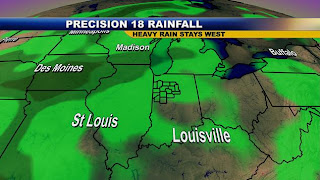
This big dip in the jet stream combined with a cold-core low pressure system is never good news for those in the Midwest this time of year, especially if you have already put your coats away in the attic. The Mushroom Mauler will be watched carefully, that is for sure. Now on a more serious note, the farmers have been asking for some rain, but not too much so they can continue to catch up on planting crops. Well, I have perfect planting weather for the farmers because the latest precision weather maps have us receiving less than a half-inch of rain between now and Friday night and only light amounts into next week. As I showed you below on the blog yesterday we still have a surplus of over 5 inches for the year. So this is welcome news even if it means we have to put away the shorts. Notice the deeper greens showing the heavier rain stays well west. You can thank our summer-like ridge over us for weakening this system.
We are also dodging the bullet on the severe weather this week, so even though we have a few tough days ahead by early next week, we are doing pretty well by Hoosier standards! Carry on and have a great day. I rode my bike to work yesterday like I said I would. It took an hour to go the 9 or so miles, but it was well worth it! I may have to do this every day after looking at the latest gas prices. Off to Frontier High School later this morning! Dan's class is always fun to visit this time every year. I will snap some pictures for you and see you soon! Keep those mushroom reports and pictures coming in.
Wednesday, April 23, 2008
Great Car Washing Weather Today!
Year: 1969
Make: Volkswagen
Model: Bus
Found in New Mexico. Comes complete with stereo, curtains, dining table, bench seat that folds into full size bed, and other camping accessories.Brandon
Stop the presses! We finally missed out on some rain last night. I know I forecasted it to stay dry but this is quite a turnaround. I want to thank Brandon who is our new floor director at WLFI for sharing this impressive picture of his "baby" you see above. This car is extra special to me since it was made in the same year I was born. It is a beauty and after he washed and waxed it, as smooth as silk. Today we will have some fine car washing weather. The next good chance of any widespread rain will hold off until Friday. We have a ridge of high pressure detouring storms well to our north and west. By time these fronts arrive at home they have little or no punch left. Even the system coming in on Friday does not look too bad at this time. The March for Babies on Saturday morning looks dry right now and I will have updates as we get closer.
Here is the latest yearly precipitation for Lafayette you see above. Believe it or not we are about .76" below average on rainfall in April. But even with a drier than average month we are still a good 5 inches of precipitation above average for the year. Yesterday it hit 77 in Chalmers! The next big news will be our first 80 degree day possible tomorrow. I will have more on this tonight along with our first reports of mushrooms being reported around the area.
Stay tuned and make sure to tune in tonight for our big weather special! It features the 1974 Monticello tornado from a perspective you have never seen before.
Tuesday, April 22, 2008
Happy Earth Day! Mayflower Mill Students Walk to School to Spark Awareness
Megan's Mom and my tough, yet beautiful wife walked with her despite needing 3 stitches this morning from an injury she had last night while helping with a school project. I held down the fort at home early this morning and look forward to biking to work this week and leaving the car at home. Lauren my three year old was taught how important recycling is and helped me sort through newspapers, plastics, and cans this morning.
Lauren, my 3 year old, will post her exclusive interview here on the weather blog about how other kids are helping make a difference. They are our future and today it is certainly looking brighter. Earth Day was founded in 1970. John F. Kennedy and Robert Kennedy also helped to push things along from the idea that was conceived back in 1962 by Nelson. They all were instrumental in making Congress more aware of the importance of taking care of Mother Earth. The environment was largely an issue that was ignored back then, but things have certainly changed today and that is a good thing. But we still have a long way to go.
Lauren's interview: Why did my doggie walk with you to school?
Megan: It is Earth Day and it is important to know that there are many things you can do to make a difference. By walking with BJ this morning we kept 10 micrograms of potentially cancer-causing polycyclic aromatic hydrocarbons from being released into the air. This means you can go to the park and have lots of fun!
Lauren: Can I watch Wonder Pets on TV after the park?
Megan: Yes, but remember that when your TV no longer works you have to recycle it just like you would your old coloring books. A 27 inch TV can produce up to 8 pounds of lead which can be released into the air and our water supplies.
Lauren: Can I play Webkinz or will that hurt Earth?
Megan: You can play computer games, but once your computer does not work you need to recycle it like your TV. Computers also contain lead along with cadmium and mercury. This can hurt earth and you.
Lauren: Can we plant flowers or trees to make Earth pretty?
Megan: Yes, planting trees and flowers is another sure way of taking care of the environment. Trees absorb yucky air that makes you cough or what we call pollution. They also provide homes for birds and other animals and give off plenty off oxygen so we can all breathe easier. They help us save on air conditioner costs and reduce flash flooding so Daddy doesn't have to go to work as much.
Lauren: Thanks Megan, now we can play!
Megan: One last thing to remember...Each ton (2000 pounds) of recycled paper can save 17 trees, 380 gallons of oil, three cubic yards of landfill space, 4000 kilowatts of energy, and 7000 gallons of water. This represents a 64% energy savings, a 58% water savings, and 60 pounds less of air pollution! If you don't choose to reuse the planet will lose.
Great job kids! Megan said her friend Kirsten along with her Mom walked to school with them this morning and the 3rd, 4th, and 5th grade classes at Mayflower cleaned all the trash up around the school grounds today. They found tons of trash. Now hopefully when you get older you will no longer need cars that fill up with gas. Enough is enough. Vote: Megan Prangley! I think she will make a great President some day. Lauren is well on her way to being a successful TV anchor. She had some pointed questions that helped teach me about things that I had no idea would hurt the planet. I will never look at my computer the same. As we all can now see, taking care of the environment is no longer important but a necessity. The gas prices are a sure warning sign that change is needed and there is no turning back.
Monday, April 21, 2008
22 Aftershocks & Counting As May Pattern Settles In
Now that was impressive. In the 1987 quake there were a few more reports of damage than this past one. I know cracked window panes were much more common. So we can consider ourselves lucky this time around.
Friday, April 18, 2008
Good Sleeping Weather Tonight & Keep Those Weekend Plans
Kathy Moon sent this picture of a beautiful sunrise in Monon after our earthquake. If this is earthquake weather I certainly like it! Is there such a thing? Why did some folks celebrate our earthquake Friday with meatballs? So many questions, so little time. But I will have answers here for you when I catch up.
Aftershocks Continue in Lafayette as a 4.6 is Registered
New data updated at NOON:
Seismologists are now upgrading the aftershock we had after 11 a.m. to a 4.6 earthquake which is unusually strong and quite significant for an aftershock. Remember post-earthquake tremors can continue 3 days after the main earthquake.
Seismologists said the Midwest vibrated a good 15 minutes after the main earthquake on their sensitive equipment and it will go down as the Midwest and East Coast regions strongest earthquake since 1968. This may or may not be a warning sign of heightened activity.
The New Madrid fault line is located in a much heavier populated area than it was back in the 1800's when it had the "big one" hit. A repeat of this which is forecasted by some scientists would be absolutely devastating with significant damage likely even here at home in the Lafayette, especially to older structures and old brick buildings. Windows would also be shattered.
Lafayette lies on a WABASH VALLEY FAULT ZONE which likely was an active "ancient" fault zone. This is the northern extension of the New Madrid fault line.
Here is an easy link to see the latest earthquake information on what is happening right now.
http://earthquake.usgs.gov/eqcenter/recenteqsus/Maps/US2/37.39.-89.-87.php
Some more viewer feedback: The main earthquake that hit just before 5:40 a.m. was worse than the one that hit our area in 1968, but not as bad as the 1987 earthquake that actually knocked people off their feet. Actual waves were seen along the ground in some farm fields.
Strongest Earthquake Since 1987 Rattles Lafayette
Where was I? It was just before 5:40 a.m. and I was sleeping with my wife and then boom, we both woke up to what sounded like a hurricane force gust of wind hitting the house, only it had a sensation I have never heard or felt. Our house was literally shaking and I knew there were no storms and I did not forecast any high winds. So I ran to the window, by time I got to the window the shaking had stopped. I immediately ran downstairs and outside to barking dogs and then I shouted it was an earthquake! I then went in immediately to the US Geological Survey web-site and it was confirmed within 10 minutes. I had goosebumps for at least 30 minutes afterwards while I was relaying this information to WLFI and my family. My daughter said the small TV in her room actually moved. Everybody in our house except Abbey heard it. This earthquake was felt as far north as southern Canada and as far south as Florida. No major injuries or damages have been reported. In Louisville there are reports of damage to a building facade.
This was officially a moderate earthquake was a magnitude of 5.2 on the Richter scale. It was centered near West Salem, Illinois which is located in the Wabash Valley Seismic zone. It is about 180 miles from West Lafayette.This is the norhward extension of the New Madrid Fault line. This type of thing only happens once every 20 years on average in our part of the state. There have been 8 aftershocks reported since the original earthquake hit at 5:36 a.m. The good news is that usually aftershocks are much weaker and we have not felt any of these here in Lafayette. Aftershocks can last 2 to 3 days after the main event. If we have anything stronger than an aftershock over the next couple of days here are some earthquake safety tips:
Get under a heavy piece of furniture or sturdy door frame.
If outside stay away from trees, buildings, and powerlines.
Remember you can relax now. The worst should be over! Have some doughnuts and coffee and talk about it with your friends.
I already called Mom and Dad in Jacksonville, Florida and they are glad everybody is safe and sound here in Indiana. When my Mom lived in Japan she told me that it happened there all the time. It can be frightening for those that are not used to it.
Earthquake Facts of the Day: Kind of eerie...Today is the 102 Year Anniversary of the Great San Francisco Earthquake back in 1906....
April 18,1906 a devastating earthquake hit San Francisco at just after 5 a.m. The good news for us today here at home is that no significant damage or injuries have been reported. You usually do not have any significant damage with earthquakes under a magnitude of 6.0. But over that number, damage is likely and exponentially rises in a hurry. Take care and stay safe. Please send in some of your stories. Now I better get my day going. I am still in awe of the whole thing.
Earthquake Shakes Lafayette This Morning
5.4 (Preliminary magnitude — subject to revision)
Date-Time
Friday, April 18, 2008 at 09:36:57 UTC
Friday, April 18, 2008 at 04:36:57 AM at epicenter
Location
38.501°N, 87.898°W
Depth
10 km (6.2 miles) set by location program
Region
ILLINOIS
Distances
10 km (6 miles) ESE (103°) from West Salem, IL
10 km (6 miles) NE (55°) from Bone Gap, IL
13 km (8 miles) N (4°) from Bellmont, IL
66 km (41 miles) NNW (333°) from Evansville, IN
204 km (127 miles) E (93°) from St. Louis, MO
Location Uncertainty
Error estimate not available
Parameters
NST=021, Nph=021, Dmin=263.2 km, Rmss=1.07 sec, Gp=119°,M-type=moment magnitude (Mw), Version=1
Source
West Coast and Alaska Tsunami Warning Center/NOAA/NWS
Event ID
at00851141
This event has been reviewed by a seismologist.
The latest information can be obtained by this link.
http://earthquake.usgs.gov/eqcenter/recenteqsus/Quakes/us2008qza6.php
Thursday, April 17, 2008
More Thunder from Jets than Nature in the Sky
Sure enough by this afternoon we find out that fighter jets in training were to blame. The bright lights were flares that were used in their war games. This I guess was Indiana's version of Top Gun. Uusually this time of year it is nature that is top gun and putting us in the danger zone. We know the man-made thunder from the jets will not outdue nature's thunder much longer. Sure enough, looking at the long-range maps I do see an increased risk of thunder and severe weather by the middle and end of next week. So let's just enjoy this quiet weather while we have it.
The weekend storm system looks weak at best and it will be tough just to get a heavy rain shower out of it. Should we name it a male "W" with a quarter inch of rain or less on the way? This will be a tough decision. So remember "scattered" showers is the key word which means it will not be an all-day rain on Saturday and do not cancel those garage sales. Now if you were disappointed in not seeing shooting stars last night I will make sure to post the next few meteor showers here. So check back a little later tonight. Oh yes! The severe weather special is looking great and I will post some tidbits from that as well.
Wednesday, April 16, 2008
Sneezing? Lots of Pollen & Omega in the Forecast
Well, it can be miserable for allergy sufferers this time of year, but it still is an improvement compared to what we have been going through this year. The pollen count will remain in the high range through at least Friday so make sure to get out the tissues along with your short sleeves! We also have a lot of omega in the forecast. What is that? Tune in tonight to find out and I will have more on the blog here later this evening. In the meantime enjoy the tulips basking in the sunshine above! What a gorgeous day!
One interesting note....all the new maps have slowed down everything by up to 24 hours. This will impact our weekend. Instead of the rain showers mainly on Friday, they could still linger into Saturday. The good news is it is a weak system and I do not expect all day rains. I will have the new model data in for you by later this evening. Keep those garage sale plans for now!
Tuesday, April 15, 2008
Warmest Weather of the Year on the Way!
It was a cold start this morning with lows of 26 in Lafayette to 29 in Monticello. You see the Prangley lawn frost-tipped. The amazing part is lawn mowers were revved up in my neighborhood by 1 p.m. and you could hear at least a couple in the distance. That is Indiana for you! The good news is looking at our current pattern with a weakening La Nina, we may not have to worry about 20s again until next autumn. You never say never in Indiana but the worst of the cold may be over! I forecasted a warmer than average April and it is looking to work out that way. Look for highs in the middle 70s on the way for Wednesday and Thursday which will easily be our warmest days of the year!
One big note today is that by this time last year we had 11 days of 70 or above. This year we have an anemic 2 days of 70 or above, but in my 7 day forecast tonight we will more than double this number. Get ready for lots of catching up. Nature owes us!
You also know what this means Hoosiers. It is mushroom time! You see we had a bumper crop last year. This year we still have a decent shot of at least an average season which is good. We have been a bit too stormy and chilly at times. We have had plenty of moisture to work with but one of the big ingredients is warm weather and now that it is here there have already been some rumors of good pickings off state road 25. I cannot confirm or deny this. A friendly reminder to you is to get permission to mushroom hunt on private property. I will check back with you soon. I am working on a severe weather special all week that will air next Wednesday at 7:30 p.m. So please bear with me here on the blog. My posts may be a little more abbreviated. But it is my closest contact with you many times, so I will do my best to keep it fresh. I will post as much as I can and even give you a few tidbits coming up in the special. Now back to work on the Monticello tornado that hit in 1974.
A big thanks to Doug Fleming and Roosevelt Middle School for helping us last Friday on this special and I cannot thank Gordy Cochran, Mark Robertson, along with Gordy's Mom and sister enough. They took me back to that fateful day and I felt like I was there. Also, Larry Crabb tells us of a local storm story you will never forget! Remember to tune in next Wednesday at 7:30 p.m here on WLFI!
Monday, April 14, 2008
Looking Like Spring & Soon to Be Feeling Like It!
First of all....I cannot thank all those enough who came out for the first ever cancer center challenge at Purdue. It poured just before the race and it was cold! But it turned into a beautiful day thanks to you and I really enjoyed running and chatting with many of you! There were many great stories and it made running up those two big hills much easier. Enjoy the picture above of those that help make this community a special place. I look forward to seeing you out there next year.
Friday, April 11, 2008
We Have the All Clear! Now It's Time to Lace Up Those Shoes to Stay Warm!
http://www.cancer.purdue.edu/Purdue5K/index.php
You can have fun and make a difference. It will be a great way to stay warm as well! It is what I call good running weather. I will have your running and weekend forecast posted on here later today and also a few more thoughts on Vicky and just how lucky we were. Have a great day and weekend! I am off to a book fair, teacher conference, and Monticello to talk to those that went through the big April 3, 1974 tornado. More details will be posted here in the future on what I find! One thing is for sure.....we dodged a Super Outbreak this time around and we are all counting our blessings here at home.
Thursday, April 10, 2008
Good News for Us on the T-Storms & Flooding!
I do not see a weather watch for us and the main threats with the thunderstorms tonight and Friday morning if the second line does in fact form will be lightning, wind gusts near 40 mph, and heavy rain.
The second bit of good news is there will not be training of thunderstorms and I do not see any 3, 4, or 5 inch gully washers out there tonight and Friday morning. Most of us should end up with one to two inches of rain and this means no major flooding! Sleep tight and don't let the bed bugs bite...I will be here just in case we have anything bigger pop up.
Vicky Slows Down & Tracks Farther West
We have a 25% chance of 58 mph wind gusts or higher late tonight and Friday morning within 25 miles of your backyard. I have a high wind gust potential at 60 to 65 mph as our 5,000 foot winds increase tonight to near 70 mph. This can sometimes be forced or pushed to the ground during strong thunderstorms.
There is a 20% chance of large hail of nickel size or greater. I think the higher threat of hail would be across north and northwest portions of our viewing area.
There is a 5% chance of a tornado, but right now the greatest threat for that happening looks to be in southern Indiana, especially south of Bloomington.
The storm track is a bit farther west which we saw so many times during the winter...so instead of missing out on snow, we could very well miss out on the brunt of the severe weather. But remember it only takes one isolated storm to cause big trouble around here.
Update on the Meteorological Soundings:
CAPE will rise to near 1,000 j/kg late tonight and early Friday morning.
The LIFTED INDEX will be near -3 by morning.
TOTAL TOTALS OF 51.
I will have the charts on these numbers and what they mean here this evening and post the changes to get some trends. It is all about NOWCASTING in these situations and that is why Live Doppler 18 is so important. I will keep you posted. A special thanks to our Purdue intern Pat Wright for putting this together for us while I did some weather maps this afternoon!
Lifted Index:
+3 to +1: Slightly Unstable, chance of showers
+1 to -1: Unstable, expect showers and possibly an isolated thunderstorm
-1 to -3: Moderately Unstable, supports widespread thunderstorms
-3 to -6: Very unstable, widespread thunderstorms that may be severe
< -6: Extremely unstable, widespread severe weather
Total Totals:
44-46: Spotty weak thunderstorms
46-48: Isolated moderate thunderstorms
48-50: Heavy thunderstorms
50-52: Heavy thunderstorms with hail possible
52-56: Heavy thunderstorms with hail and possibly tornadoes
56 or greater: Heavy thunderstorms with tornadoes likely
CAPE
500-1000 J/kg: Thunderstorms are possible
1000-2500 J/kg: Moderate thunderstorms, possibly severe
>2500 J/kg: Severe Thunderstorms likely
These numbers are only guides and should not be taken literally, just like our weather models.
All Eyes on Live Doppler 18 As Vicky Moves Our Way
I am going to keep this shorter than usual here in the wee hours of the morning so I can get some rest and pace myself for Storm Vicky...here is the latest....everything is moving slower which may work in our favor at least for much of today. Jeff Smith wants me to keep the big storms away until after Obama leaves town later this evening. He may get his wish, but then again he may not.Timing of thunderstorms is very tricky in the field of meteorology. The resolution of our models just cannot pick up on these mesoscale features. It isn't always black and white in life or in meteorology, but a gray area we have to deal with. Thank goodness for Live Doppler 18. Things could really get interesting by later tonight into Friday with a potent storm. This storm is named Vicky because it will be like an inland hurricane based on its pressure falling to 984 millibars. Normally this is something you would see associated with a category one hurricane. This is downright impressive! If you look at the hurricane names for 2008, Vicky is the the "V" name so it works well here. It will be the strongest storm of the season easily. We skipped "U" because it is not traditionally used when naming storms. Now I will have an update coming your way here on the blog about exactly what you can expect and when.
Wednesday, April 9, 2008
Nature Puts on A Lightning Show in Indiana, Minnesota Is Still Digging Out!
How many cloud to ground lightning bolts in 2 hours last night? Over 1,000 which is not too shabby. One lightning bolt has enough energy to power 2.5 million car batteries. In an age where we are looking for alternative energy sources, I say we go back to the future and try to harness lightning. Ben Franklin's kite experiment needs to be taken to the next level. Lightning is caused by ice at the top of the cloud interacting with raindrops and supercooled raindrops. Even though the lightning was impressive, the storms only grew to about 30,000 feet due to a lack of instability and moisture. The higher the cumulonimbus cloud, the stronger the updrafts and potential for strong storms. Last night we did not get any of those 40,000 to 50,000 foot cloud tops that usually bring severe weather here in Indiana. This kept things in check with no severe weather watches or warnings. You can see that clearly on X-Vision below as I scanned the storms in 3-D!
The highest wind gust here at WLFI was 33 mph just after 1 a.m. This same thunderstorm rumbled up to Carroll County. Our Precision 18 Storm Tracker did a great job pinpointing exactly where the storm was and where it was moving.
Dayton which is know as tornado alley in our viewing area had just a typical thunderstorm move through at quarter after one while Delphi had an early wake-up call close to 1:30 a.m. I am glad we dodged the worst of the weather tonight. I have just one wind damage report out of Illinois near Ford County and that is it! It could be a different story Thursday into Friday. We have the main storm coming at us late week that could drop our temperatures at least 40 degress not including wind chills and maybe even bring us a little bit of snow. But it could always be worse! Check out these pictures sent in by the Stanforths' up in Orr, Minnesota.
These pictures are for real. The nice people in these pictures are Lisa Stanforth's Mom and Dad. She is our morning producer or who I like the call the Mary Tyler Moore of our news staff!
Mike and Kelly,
We are Lisa's parents, and thought you would appreciate a couple pictures from today. We are in northern Minnesota where we got over 24 inches in the last 24 hours. From the snow still standing in our woods, we have 3 to 4 foot in places (in April!!) We walked in to our lake/cabin property, which we were hoping to drive in- no such luck. none of these pics are faked (no kneeling in the snow!)
--Mark & Madelyn Stanforth
Thanks so much and the good news is that all the snow will be gone by May and the lakes which have suffered so dearly up in Minnesota with drought conditions will be replenished. Now get home Mark and Madelyn before the next blizzard hits Minnesota by late this week and weekend. Yes, we are in a historic pattern! Batten down the hatches here in Indiana. This pattern is only beginning and here comes a classic Spring storm for us on Thursday and Friday. Stay alert to changing weather conditions, stay safe, and stay tuned. In the meantime here are the incredible snow totals courtesy of the National Weather Service in Duluth from this past weekend in Minnesota.
The 30" of snow near Hibbing is only about 50 miles south of Orr and at least this incredible snow did not fall on Halloween weekend like portions of Minnesota saw back in 1991. It was caused by the "Perfect Storm" off Nova Scotia and New Foundland. This blocked all our weather here in the United States and caused a big log jam in our storm systems. A little snow or dusting of snow that was called for in Minnesota did not stop for 3 days. Some areas saw over 50 inches of snow in the Arrowhead. This week Minnesota may top that 50 inch mark in northern Minnesota. It looks to be their snowiest week in 17 years. Yes, blame the crocus crusher! Have a great day and now those 40s and flurries this weekend should be much easier to take. So no complaining! :)
Tuesday, April 8, 2008
Weather Watch Will Not Be Issued for Lafayette
Storms Need To Be Watched Carefully Tonight
Dewpoints of 60 or above are having a tough time moving north which could limit our severe weather here at home, otherwise or atmosphere is a loaded gun. We could still have isolated strong storms producing wind gusts of 50 mph and quarter size hail. The main threat will arrive between 9 p.m. and 12 a.m. I will keep you posted.
Daffodil Delight to a Crocus Crushing Weather Pattern
Severe weather tonight looks minimal with the highest risk staying to our south and west, but we still have the potential for some lightning, 40 mph wind gusts, and pea-size hail. Things could get a little more serious here at home later this week. I will have more on this tonight. Make it a great day! At least we will have one more daffodil delight for most of today before the crocus crushing pattern moves in. It is a good thing us Hoosiers are tough. Have a great day and have a great run!
Monday, April 7, 2008
Wonderful Weekend Weather Turns Woeful This Week!
It was a weekend to remember for wonderful weather and lots of good, quality family time. As I get older this becomes even more important to me. I think it is because before I know it these 3 girls of mine will be teenagers. So we hit the trails of West Lafayette on our bikes. Lauren who still has training wheels actually did a great job and went at least a couple miles with the family. We did a little pit stop at the park so she could rest her little legs. She fell asleep in a hurry last night. Megan and Abbey found a way to turn it into a competition of course and I explained that it was not a race. Apparently I ended up in last place according to Abbey. BJ our dog you see in the picture actually trotted beside our bikes for a good part of the way and he was still running around last night. That dog is amazing! He could be the energizer dog. My wife then got home and somehow found the time and energy to cut up some great strawberries, cantaloupe, and the best watermelon. She even found some corn that went well with our beef and noodles. It was great being able to eat outside again! Thank you Julie! I may have run 5 marathons, but she runs a marathon about once a week with all the things going on in our family. I just run to try to stay and shape and keep up with all my girls. I wouldn't trade it for the world.
Some other highlights including going to Dog N Suds with Megan after her ballet practice while Abbey and Lauren were at gymnastics. There is nothing like a Coney Dog as your first real Spring weather days move in. We all then somehow met up at Abbey's soccer game. The Greater Lafayette Recreatonal Soccer Alliance has over 200 teams this year which is a new record. My hats off to Rodney Tucker, Boyd Wheeler and all the other volunteers that help put this together every year. The Davidson fields actually drained pretty well in all that sunlight yesterday.
It is a blast watching these young kids growing up before your eyes year in and year out. Abbey's soccer team has gone from little toddlers to tall, athletic girls in just a few short years. I wouldn't have been able to stop a couple of those kicks and the coaches are doing a great job teaching teamwork. Abbey had two assists and I told her that in my book that is better than a goal. Making others around you better is what it is all about not just on the soccer field, but in life!
Now since we are talking about life. Such is life here in Indiana that it is very rare to have more than a few nice days in a row without a reality check. Nature likes playing April Fools Jokes on us throughout much of April and sometimes early May...so here is the deal...we will be paying for this nice weather with a penalty kick.
The latest maps in today are no joke. I expect over 100 tornadoes across the country this week, flooding, more blizzard conditions, and even some record highs and lows. Here at home this means we will have a week of all seasons that includes humidity, heavy rain, strong thunderstorms, and yes even snow. I will be back for more on this. Get outside while you can! This evening looks terrific! You can put the fertilizer down before the rain moves in late tomorrow, and especially tomorrow night!