The latest snow totals coming in from Illinois are impressive with nearly 6 inches of snow reported near Kankakee. This heavy snow band will pivot into Newton, Jasper, Pulaski, and Fulton Counties tonight. These are the areas that look to end up with the heaviest snow. I will also include White, Cass, and Miami Counties in the 3 to 6 inch snow band.
Here in Lafayette the storm track has shifted far enough north where we will be in the lighter amounts or closer to 1 to 3 inches of snow before all is said and done. Indianapolis will likely end up with only about an inch of snow. Two things have changed with this storm in the last 6 hours. Colder air is taking its time moving in which is cutting down on snow totals and the dreaded dry slot has worked into much of the area due to the low pressure tracking about 40 miles farther north than earlier model runs indicated.
But remember travel will become rough through much of central and northern Indiana due to plummeting temperatures and wind gusts near 40 mph blowing the snow around. Have a safe and happy New Year!
Monday, December 31, 2007
Back From Wisconsin & Brought Back Some Snow With Me!

Sammy the Snowman with Anthony, Abbey, and Megan
in Oconomowoc, Wisconsin
New Year's Eve Winter Storm Update
It is great to be home after snow-chasing and spending some great family time in Wisconsin. The snow chase was a success as Milwaukee rewrote the record books by experiencing its second snowiest December ever. I was in Oconomowoc, Wisconisn where 6.5 inches of snow blanketed the area on Friday. There were a few isolated 8 inch totals. The only thing keeping me from witnessing a foot of snow was the quick movement of the system. I enjoyed playing out in the snow with the kids and my nephew. We built a huge snowman you see above and you can see me on top of a 25 foot snow bank below. It was a fun storm that produced 4 hours of visibility reduced to a quarter-mile or less due to heavy snowfall. The snow piled up in a hurry! There was very little wind and it was a heavy packing snow which made it a blast to play in. I helped shovel out driveways and used a snowblower for the first time in my life!

Here at home we have an interesting low pressure coming through in time for the New Year. I think most of us will see 3 to 5 inches of snow. There will be a band of 5 to 8 inches of snow setting up and there is still some uncertainty on exactly where that band will set up. Looking at the latest satellites, radars, and model data I would favor the heaviest band of snow in extreme northern Indiana which may nip Pulaski and Fulton Counties. If you are heading toward Fort Wayne this seems to be the bullseye of the storm for Indiana. This storm will be rapidly deepening as it moves by our area, but because it is moving so quickly I will keep our viewing area in the lighter amounts at this time. But do not let the lower amounts fool you. By morning it could look like you are waking up to a blizzard with wind gusts of 40 mph along with blowing and drifting snow. Our roads will be slick and snow covered. This scene in Wisconsin could be repeated here at home by late tonight and New Year's Day.

I am concerned about all the folks traveling to New Year's Eve parties tonight or to family gatherings on Tuesday. If possible, I would try to stick closer to home and if you do not need to travel, by all means do not. It will be a good idea to stay home and heat up a cup of hot chocolate. Roads will be bad and wind chills will fall to near zero on New Year's Day. So it will not be the type of weather you will want to get stuck or stranded in. If you must travel, take extra blankets and your winter survival kit.
Our snow advisory in effect for tonight through 6 a.m. Tuesday may be extended as a Blowing & Drifting Snow Advisory on New Year's Day. I will not be back in the office until Wednesday, but will keep in touch with you here on the weather blog if I see any major changes to the forecast.
Happy New Year and it is a fitting end to 2007 which will go down as Lafayette's snowiest year on record! Enjoy the snow but please be safe so I can see you again on Wednesday!
Wednesday, December 26, 2007
Warmest Late December Pattern in 16 Years for Lafayette!

What a wonderful day today! The last time I could find temperatures this warm on December 26th was way back in 1991. Today's official high in Lafayette reached a whopping 48. You see above why we have no real winter weather in sight. Most of the cold air is bottled up north of the jet stream and this zonal flow is usually a much quieter pattern for us. So the big blog question of the day is when will winter return. It does look like winter will be back but not until New Year's Eve. I still do not see any big storms or New Year's blizzards to worry about.

Even though it will be an impressive shot of cold air we do not have any snow on the ground to really sustain that arctic air for very long and it should modify by time it arrives in Lafayette. So instead of highs in the single digits and teens for New Years, get ready for highs in the much more bearable 20s. In fact the latest long-range maps, have every single state except Alaska in the above average temperature category for the first two weeks of January. It looks like somebody spilled red paint on all my long-range maps but of course it is the result of the Pacific jet stream taking over the pattern which we see during La Nina years. But remember in a La Nina pattern the pendulum swings the other way and it certainly can turn snowy and icy in a hurry. This likely will take place in February and March. But as always we have to keep our guard up at all times here in Indiana and we will keep you updated.

So what is a meteorologist to do in such a quiet pattern! Well, go snow-chasing of course! YESSS!! If you are gong snow-chasing like I am it looks like Wisconsin is the place to be with a swath of 3 to 5 inches of snowfall expected on Friday. But with some impressive forcing coming together on the latest maps I think there could be some isolated 8 inch amounts. Snow-chasers are becoming more popular nowadays and they are the equivalent of storm chasers only instead of looking for tornadoes they look for big snowstorms. I have always wanted to do this and I can thank my family up in Wisconsin for having their reunion this weekend. So the timing could not be better. I will make sure to enjoy my family and all the cheeseheads and of course the snowstorm. The good news is I am not missing any big snowstorms in Lafayette. But the weatherman curse usually hits hard this time of year. I am on vacation through New Year's Day so I will leave it up to my blog readers to keep all storms away until I get back. I will miss writing to you so I will try to check in with you from Wisconsin from on top of a snowbank. It is the least I can do for all the snow-lovers we have in Lafayette. Have a wonderful rest of 2007 and a great start to 2008! Let it snow, let it snow, let it snow.

Tuesday, December 25, 2007
Merry Christmas from Our Family To Yours!

The Prangley girls and dog cannot wait another minute to open their presents!

Christmas choir singing like angels at St.Tom's.
Monday, December 24, 2007
A Nice Quiet Christmas Eve to Enjoy

I know that many of us snow fans wanted a White Christmas but we really should not be complaining. We have had over 13 inches of snow this month. This is caused more than our fair share of travel trouble. But this year we will not have to worry about getting to Grandma's house. It was a different story however in 2002. Lafayette was lambasted with more than 7 inches of snow. It was our snowiest Christmas Even on record and folks did have trouble just getting out of their driveways! I remember it took more than 2 hours to drive through Chicago on my way up to Wisconsin. The roads were more like beaches there were so much snow on them and I am talking about the actual interstate. Now if you are wondering who will have a White Christmas take a look below.

Much of the country including a good portion of Missouri will have a White Christmas. One thing that is noticeable is much of the West is covered in snow. That is due to our pattern doing a flip-flop. The big trough we have had over us bringing us a lot of snow the last couple weeks has certainly shifted to the West. While we have ridging in our neck of the woods that has helped melt over 10 inches of snow in just 7 days. But we can look on the bright side and that is we will have a nice bright sunny Christmas even though it is our cloudiest month of the year. Another silver lining in our lifting clouds will be good travel weather for those heading to Detroit for the Motor City Bowl. Ford Field is indoors so you should be comfortable for the game, but the hard part is usually getting there. Well, this year no problems are expected! Here is the latest forecast for Detroit.

Friday, December 21, 2007
Nice Mild Finish to Autumn But Winter Comes in Squirrelly

Today will be our warmest day in about 3 weeks and it will even be warmer for the first full day of winter on Saturday. But do not get used to it. We are tracking 5 storms in the next 2 weeks and we may even have some light snow accumulations this weekend after some rumbles of thunder! That could make it two weekends in a row with thunder! Join me tonight for the latest on this and all your travel weather. I will see you soon! In the meantime I have a squirrel update for you.

Mike,
Earl the squirrel says he is ready for the melt down. He has gotten to were he doesn't like being in the snow. Today he decided to sit on top of the truck for for while. Give Earl what he wants.
Heidi Cobleigh
Thanks Heidi. Tell Earl it is not even winter yet so it is too early to be complaining. The weather is Earl's fault to begin with as I said here on the blog a few days ago. Earl was the busy one gathering food and telling us some real cold and snowy weather was on the way. Since I have been ecstatic with the snow I can give Earl a two day break but nothing more. Santa needs a little snow for the sled to land on and Earl will have to be in the truck with the heat on by Sunday with temperatures falling through the 20s with snow showers and blustery conditions. It certainly looks like a squirrelly start to winter!
Thursday, December 20, 2007
Freezing Fog & Melting Frogs The Bigger Stories During Christmas Week

Well, I certainly was not going to sleep until I had some more answers. You see the map that shook the weather office yesterday afternoon that showed Lafayette with another big snowstorm threat. I proceeded with caution until the other models came in line with it. I knew I could not guarantee another blockbuster storm based on one model run. Our models are updated every 6 hours. So the good news is I got to look at another two model runs and to check out the other possible storm tracks that could bring us snow. Here is what I found. The storm track above was the outlier of all our model solutions or the most outrageous. I have effectively disregarded it. The more likely storm tracks you can see below.

Notice we have too much high pressure in place here in the Midwest so the main storm track is being pushed farther south and east. If track #4 verifies it could bring blizzard conditions to parts of the East Coast but a lot still needs to happen and in this pattern you need to take it one day at a time. So I know all the snow-lovers are saying bah-humbug, but we have had it really good here in 2007. Also this is this is great news for most travelers and even those heading to Detroit to cheer on the Boilermakers in the Motor City Bowl on December 26th. But if you are heading south toward Tennessee or Kentucky and east toward Maryland you may want to check those travel plans.

This means we need to be careful of freezing fog with all the melting snow that is adding moisture to the lower levels of the atmosphere and yes, melting frogs. Check out the picture sent in from Reynolds! Robin Davis made a 5 foot six inch snowfrog in about 2 hours. Since we have had snow it has become a real good packing snow. I am amazed by this. This frog is almost as tall as I am and I wish I had half the talent Robin has to be able to make something like this. I wish she could somehow preserve the frog and it would not melt. Somebody find a train to the North Pole before it is too late. The weekend temperatures could be the warmest we have seen in several weeks. So be careful of the fog and I will have more on the impressive warm-up tonight. I will also post pictures from the good old-fashioned Christmas dinner at Prophetstown last night. The Williams Family which happen to be my next door neighbors were the winners. No, it was not a snow job. But, it was a pleasant coincidence and they were very deserving of it, especially since they have to live next door to the Prangley family. Check back here on the blog for more on this and in the meantime make it a great day.
Wednesday, December 19, 2007
Breaking News: A Major Christmas Snowstorm is Possible
1:45 p.m. Stunning new weather data arrives in Lafayette from Washington, D.C.

It is still early but when you see the potential on a couple long-range models of 6 or more inches of snow on Christmas day you need to pass it on. The break in the active weather will be much shorter than previously thought. We will be bright for Christmas Eve with possible heavy snow developing on Christmas. Since only a couple models show the storm I will watch things very closely the next couple days. By the weekend I should be able to verify that another big snowstorm is on the way. I want to wait until there is more agreement, but in the La Nina pattern we are currently in which keeps hitting us with big storms, my gut tells me we are in for another big one. I already have a T-Shirt that says I survived the blizzard of 1978. I need to add another T-Shirt to my collection that says I survived the great snow year of 2007 which will be going down in the books as the snowiest year on record for Lafayette.
Wolves on Ice & Lots of Nice Light Displays to Check Out!

Monty Sloan was born with a lot of talent when it comes to taking pictures and he gives all the credit to nature that was cooperating yesterday evening in Battle Ground. The wolves at Wolf Park were enjoying the sunset on ice. We have not had much sunlight in the month of December with most of us only receiving only about one-third of our possible sunshine in this stormy and cold month. Have you felt a little down. This could be the reason why, especially if you do not like snow. But things are changing for the better as a tranquil pattern is developing. This picture shows the pattern change. Now we will have a good deal of clouds caused by melting snow cover and a couple of Pacific weather systems on the way, but overall we will finally brighten things up in time for Christmas and the last week of 2007. A lot of us our dreaming of a Bright Christmas this year and I think we will get it and we certainly deserve after all of those dark, dismal days we have had this month.

Thanks to Chris Hoover
Another thing that will help brighten your life will be some great light displays you need to check out. One of course is the Hoover display you see above. It is located in the River Bluff neighborhood on Greenview Drive in Battle Ground. The thousands of beautiful lights are synchronized to music and you can donate money to a worthy charity. You need to check it out for yourself. It is for your enjoyment during the week until 9:30 p.m. On weekends you can check it out until midnight and up until 11 p.m. on Christmas Eve. Chris and Angela Hoover are great people and I had the honor of sitting with them at a Christmas Party this year. They put a lot of time and effort into this light display every year and this year they really need your support to help their charity of choice. They are behind last year's pace of raising money but I am sure you can help them make it up in a hurry. Again you do not have to donate, but after you see the lights I think you will want to help make a difference and will be in the giving spirit. Here is more information that Chris just sent me.
Hi Mike,
I have set up a web site with some info about the display (times, station, etc). There is a link to map-quest, which has our address already filled in as the destination. The simplest description is 1.5 miles North East of Battle Ground, in River Bluff sub-division. Our web address is www.christmasongreenview.com .
As for the charity part, we are doing a couple things this year. We had set aside this past weekend (Dec 14-16) as "Battle Ground STPS" weekend, meaning that anything we collected last weekend would go back to the Student, Teacher, Parent, Staff organization at Battle Ground Elementary. Since the weather last weekend more than likely kept viewers away, we have extended the collection time for BGE thru this Thursday Evening.
All other donations we receive will be passed on to Lafayette Family Services.
Let me know if you need more info.
Chris

Thanks to Randy Rogers
Another light display to check out is the million light display at TPA Park. Randy Rogers went out to snap this picture of the million light display for you last night. They have great food and dazzling lights. Another great display to check out is the famed City of Lights in Kokomo. Have a great day and enjoy the lights and great weather to finish 2007. Make sure to tune in tonight. I have a special family I want you to meet during my weathercast at the Prophetstown Christmas dinner! We have a lot to howl about and be thankful for!
Tuesday, December 18, 2007
Rare Diamond Dust Snowflakes Spotted in Lafayette's Snowiest Year on Record

Sun pillar lights up Lafayette last year
Last night we got lucky and missed out on the worst of the freezing fog as Illinois had all of the advisories. We did however have another rare phenomenon that takes place only a couple times a year in Lafayette. We had diamond dust. It is the name of a shimmering and sparkling snowflake that kind of just floats in the sky. Temperatures have to be well below freezing and its more common in the far northern latitudes. Fairbanks, Alaska has plenty of diamond dust reports. Believe it or not, this special type of snow can actually take place when there aren't any clouds.
Sure enough last night the moon was out in West Lafayette and the stars were shining brightly when I saw these floating ice crystals in my car headlights. Basically they are floating ice crystals that form in freezing fog. The very cold air in the teens and lower 20s last night was saturated in high humidity. This allowed the high water vapor content in the air to condense out into ice crystals. This process is more prevalent at 25,000 feet in the sky, not at ground level. Wispy cirrus clouds you can say have plenty of diamond dust in them. Diamond-dust crystals are six-sided ice crystals just like other types of snow but are made of small irregular hexagonal plates instead of larger star-like flakes. This is what makes them sparkle like gemstones.
Some folks in the Arctic have told stories about being able to walk through a diamond dust cloud and then turn around and see a tunnel matching perfectly the outline of their body, where the sparkling ice crystals have disappeared, almost like footprints in the snow. This can happen because your body is literally pushing away the suspended ice crystals in the fog. These ice crystals have also been known to create sun pillars, moon pillars, and light pillars that look like beams from the horizon straight into the sky. Here in Lafayette we had a dramatic display you may have remembered in the picture above. The plate-like ice crystals become like mirrors as light is reflected above and below them with extraordinary results.
It is fitting we had this take place last night in the year of the snow. I have gone through most of the last 100 years of snowfall in Lafayette and this year we have had more snow than any other thanks to the blizzard and huge December snowstorm. It may not have been our snowiest season on record but just taking the year 2007 as a whole, it is number one on the list of snowiest years. Here is an impressive chart.

Even the great blizzard year of 1977 is no match for 2007! That is unbelieveable. The third highest snow year I could find was 1982 that was buried with 41.5 inches of snow. Keep in mind on average here in Lafayette we have 22.4 inches of snow every year. So we are long overdue for a pattern change and it does look like the pendulum is about to swing the other way as we finish out the last 13 days of the snowiest year on record. I think we will have a couple cold snaps, but overall it should be milder than average and quiet with no big snowstorms or ice storms in sight. If you want to see a big snowstorm head west as the pattern does a flip-flop. The Pacific flow is about to take over. This is typical of a La Nina pattern that is known for wild swings in temperatures and precipitation. This weekend we have a better chance of a thunderstorm on Saturday than snow. What a change! But remember the pendulum will swing back to snowy and cold just like we saw last February. So snow-lovers congratulations on your new record and may 2008 bring a lot more snow and diamond dust! It always is interesting in Indiana!
Monday, December 17, 2007
Healthy Snowpack Has Increased our Chances of Freezing Fog & Maybe A White Christmas

Trevor Miller (Age 7) Enjoying His Snow Day
It has been a fun snow day with my kids, but they thought it was too cold to go sledding so we just went out and had a nice big lunch. There is a hot chocolate advisory in effect tonight. The roads will likely re-freeze with temperatures back in the teens. One thing to watch out for tonight is freezing fog. It can cause hazardous conditions on the roads. Freezing fog can be dangerous but is also beautiful. Here is a picture of what it looked like last February. Can you pick out the squirrel?

To have freezing fog you need to have clear skies, mainly light wind, high humidity, and very cold temperatures. We should reach the criteria for this but forecasting freezing fog can be difficult. We will see if it develops tonight and if it does at least we will be ready for it.
A lot of folks are asking about our chances of a White Christmas. Well, after our big weekend snow it looks like we will at least have a patchy White Christmas, but I am forecasting mainly a rain event this weekend along with above freezing temperatures that will try to wash our snow away. The snow cover does tend to lock in the colder air longer and this will give us a gradual meltdown. This is good news for our rivers and those that are hoping we at least have a little snow on the ground for Christmas. Typically we have a 55% chance of having at least a Patchy White Christmas every year.
I do know that we are going into a much quieter pattern so even though I cannot guarantee a White Christmas, I feel much more comfortable forecasting a bright Christmas. This will probably make most of us even more excited because December has been very rough on travelers and we have already had almost 3 times our normal snowfall. The La Nina weather pattern is known for big swings in the weather and it looks like one of those big swings for the quieter and warmer is on the way as we head into the last week of December. I will have more on the pattern change and just how snowy 2007 has been. Make sure to tune in and I will have more here on the weather blog. The easiest mode of travel here in the Lafayette area the last couple weeks has been by snowmobile. Here is a great picture of how they are dealing with all the snow in Carroll County.

Thanks to Ryan Dyer
Sunday, December 16, 2007
Indiana's Jackpot Snow Total Hits 16.3" and Counting

I am looking for the real jackpot of the storm and have found it! Just two miles north of North Webster in Kosciusko County they had 16.3 inches of snow with another 1 to 2 inches of snow on the way. So there you have it! We will have snow totals up near 18 inches after all! This vicious storm did live up to its name and on the map above look for the stars. These were the areas that reported thunder snow last night. We had thunder near Williamsport, Indiana just after 12:30 a.m. for about 5 minutes and some folks near Odell thought they may have heard thunder close to 1 a.m.
It was a memorable December storm and I want to thank everybody for all the support over the last several days as the storm was developing and especially during and after the storm. You kept me fired up throughout the night last night thanks to your nice notes, great pictures and storm information. It is not easy being a meteorologist sometimes during these big storms because you look at tons of constantly changing weather data.
Your weather watchers and viewers become your most valuable assets along with Live Doppler 18 during big storms because you get real-time data that tells you what is really happening. The great pictures you send in show exactly how this storm is impacting you. This is invaluable and helps our weather team gear our forecasts for what will help you and what you need to know to ride out the storm. Not even the best weather models can replace people. You were my eyes and ears and thanks to your reports we were able to stay ahead of this powerful storm that certainly had a mind of its own. There is a state of Emergency now in Grant County where they had about a half-inch of ice and then a half-foot of snow. Travel is only allowed for emergencies. None of our maps showed this happening but we got our first signs of trouble early yesterday afternoon from weather watchers in Boswell and Frankfort just after a huge National Weather Service conference call that did not focus much at all on the ice but snowfall. So we had to quickly adjust and move forward. This was possible because of you. Thank you!
I also wanted to thank all of our staff and weather team for working around the clock to keep the public informed. Gina Quattrocchi somehow drove into work this morning during the worst part of the storm to make sure we had all the closings and cancellations for you. She took hundreds of calls by herself from 4 a.m. to 8 a.m. and did not complain to a soul! Here at TV-18 we may not have the most fancy equipment in the world like the bigger stations, but we have great people that more than make up for it.
Now back to weather. Here at home our roads will slowly improve during the day but drifting will continue through the early evening and we have an icy layer on the roads that compacted that will continue to make travel tough with temperatures tonight falling to near 10. Thanks again for the great pictures. Keep them coming and our weather team will show as many as we can over the next several days and here on the blog. I am going to go spend time with my family and rescue my wife from our 3 wild kids. I cannot wait to take them sledding! Now I finally get to play! Here are a couple pictures for you before I head home.

A Winter Wonderland in Monticello!

Can you find State Road 18 & I-65?
Folks Snowed in on the South Side of Lafyaette..2 Foot Drifts on State Road 25

Snow Drift update here at WLFI....We have snow drifts half way up some of our windows or 5 foot drifts now! We also got a report from Delphi of 8 inches of snow and 2 foot drifts on state road 25. Folks on the south side of Lafayette are having trouble just opening their doors to get outside due to drifting. This is what happens when you have over a month's worth of snowfall in one day. This December storm will go down as one of this month's biggest ever. Here are some more snowfall totals:

Mary Anne in Remington just e-mailed me saying that is not just tough for humans out there but her dog Princess Mary Margaret. She refuses to go outside. Now that is one smart dog. I know a lot of folks are itching to get outside and get on the roads but travel is still not advised through the morning. Just take my advice and if you don't want to listen to me listen to Princess.
3 Foot Drifts Being Reported With Blizzard Conditions
Here at WLFI it is just tough to walk and even talk outside. We have blizzard conditions with wind gusts just in at 35 mph and visibilities being reduced to less than a quarter mile. There is much more wind with this storm than the Blizzard back in February which makes it worse in many ways. Snow and wind do not mix very well in Indiana and the wind will not diminish until late today and early this evening. Travel is not advised. I will post updated totals right after our TV cut-in.
10.5" at WLFI as of 7:35 a.m.
Travel is not advised...blizzard conditions will continue through Noon...snow drifts of 3 to 4 feet measured out back....The wind will not start letting up until mid to late afternoon with gusts near 40 mph this morning.
Blizzard Conditions Here In West Lafayette at 2:26 a.m.

Thanks to Pete Warpo of Delphi
Wow! I did not even see it snow this hard during the blizzard of 2007. We are now up to 5.9 inches of snow with .60 inches of snow in the last 30 minutes. Speaking of blizzards we have blizzard conditions here at WLFI. It is tough to see across the street and wing gusts near 35 mph. I tried to take a digital picture, but all you see is white! We did have thunder reported in Williamsport close to 12:30 a.m. and it lasted on and off for about 5 minutes. Grant County Emergency Management just reported thunder at 2:15 a.m.are actually tracking cells on radar like we would during the summer. This storm is worth staying up all night for! Here are a few pictures of the snow picking up across our area.

Thanks to Michelle Corwin in Lafayette

Thanks to Ron Carr State Street and State Road 26
It looks like a ghost town out there tonight and the snow makes everything very quiet as it is known for absorbing sound. This is one of the many reasons I love snow! It is peaceful out there tonight. The roads around the area are treacherous not only because of the blowing and drifting snow developing but because of the icy mix we had earlier. If you do not have to travel this morning it is probably a good idea not to even if you have 4 wheel drive. The wolves at Wolf Park certainly love this weather and had a "White Christmas" celebration today with good food and even a Christmas tree.

Thanks to Monty Sloan at Wolf Park
That is right it would not be a real snowstorm without Monty's wolf pictures. I am glad I was not the only one howling with joy today and tonight when the snow finally picked up.
Travel Not Advised in Benton County
New snow totals as of 12:30 a.m.
WLFI TV-18 4"
Lafayette 4"
Monticello 3"
Chalmers 3"
The snow rates here at WLFI are now close to one inch of snow per hour....still no thunder. We are watching lightning tracker closely. The Benton County Emergency Management just sent us this message to pass along: "Conditions are threatening to the safety of the public. Only essential travel is recommended (i.e. to and from work, emergency situations, etc.) Emergency action plans have been or should be implemented by businesses, schools, government agencies and other organizations.
Saturday, December 15, 2007
First Reports of Thunder Snow in Illinois
Well we have been talking about this for much of the evening. This low pressure is rapidly deepening and is almost acting like a nor'easter would off the East Coast. Its pressure is already down to 29.47" on the home barometer and losing 15 inches per hour which is very impressive for the Midwest. This rapid deepening is causing a chain reaction in the atmosphere to take place with thunder snow now being reported. It is a pretty rare phenomenon here in the Midwest. It only happens here in Lafayette probably about once every five years and is a sign of a very intense storm.
I think we have a real good shot of thunder snow here in Indiana after midnight. So if you hear something that sounds like thunder it probably is and it causes intense snow rates to break out just like you would have heavy downpours with summer thunderstorms. No, we do not have the intense heat and humidity that causes a volatile atmosphere but we have an intense storm. I just got a call from Ed in Georgia who had never heard of this. Welcome to Indiana. I told him the only thing we will not see weatherwise is a hurricane or tropical storm, but we have everything else imaginable. I will post all your new snow totals in the next hour. Our weather team will be here throughout the night. Snow totals in Illinois are up to 7 inches in some spots and that heavier snow is moving our way. I need to get out and measue. At last check we were at 3 inches here at the station and my daughter Megan just called in 2.5 inches of snow on the south side of Lafayette.
I think we have a real good shot of thunder snow here in Indiana after midnight. So if you hear something that sounds like thunder it probably is and it causes intense snow rates to break out just like you would have heavy downpours with summer thunderstorms. No, we do not have the intense heat and humidity that causes a volatile atmosphere but we have an intense storm. I just got a call from Ed in Georgia who had never heard of this. Welcome to Indiana. I told him the only thing we will not see weatherwise is a hurricane or tropical storm, but we have everything else imaginable. I will post all your new snow totals in the next hour. Our weather team will be here throughout the night. Snow totals in Illinois are up to 7 inches in some spots and that heavier snow is moving our way. I need to get out and measue. At last check we were at 3 inches here at the station and my daughter Megan just called in 2.5 inches of snow on the south side of Lafayette.
Developing Snowstorm Thunders Our Way & Has Forecasters on Edge
It is incredible that .25" of ice has been reported in Frankfort with this system and reports of freezing rain have reached all the way up to almost Michigan. While the freezing rain has held down forecast snow amounts it looks like thunder snow tonight can more than make up for some lost time. Snowfall rates could be in the 1 to 3 inch per hour range based on the latest data and discussion with the weather service offices. The question of the night is exactly where will that thundersnow set up. So right now it looks like a solid bet that many of us will see that 10 inches of snow, but there will be a few of us with at least 14 inches of snow and even more depending on where it thunders. This storm has gone to the beat of its own drum and will make plenty of noise before all is said and done. It needs to be watched very carefully that is for sure. Our weather team is ready.
Storm Begins to Show its True Colors Over Illinois

Okay, now this is more like it. So far this storm has been very tame. Well, it is now getting its act together over Tennessee with one inch snow rates per hour developing from near St. Louis to northwestern Indiana. This heavy snow will likely move into most of the Lafayette viewing area between 1 a.m. and 5 a.m. With the low pressure rapidly developing I look for incredible lapse rates to develop with chances of thunder increasing. The atmosphere looks like it will be totally saturated at 3 a.m. all the way up to 30,000 feet. Now with all of that moisture available things could get really interesting in a hurry. I am getting my second wind and so is this storm. Lafayette has just recorded its first inch of snow with this storm. It may have taken 12 hours for the first inch, but come 3 a.m. we may see an inch of snow in only 40 minutes. Hold on to your seats! This storm may not have more snow than we saw with the blizzard back in February but the wind and snow will likely be more intense.
Updated Snowfall Accumulation Forecast
5:00 p.m.

You can see the icy mess starting to glaze up the Prangley grill.

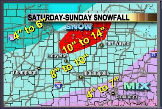
So you see what that northward trend did to our snowfall map. Anytime you add ice into the equation, forecasting snowfall amounts become even trickier. I did add Jasper County in the 10 to 14 inch band. The areas to the north that see less ice will certainly pick up the heaviest snowfall. Notice here in Tippecanoe County we are going to be closer to the 8 to 10 inch range and with blowing and drifting snow we will easily have snow drifts over 4 feet high. This storm has really not even begun and remember to slow down this evening because the icy mix of sleet, freezing rain, and snow will put down a light coating of ice that will make travel treacherous.

You can see the icy mess starting to glaze up the Prangley grill.
Storm Takes A Turn, But Beware of Round Two
4:00 p.m.
The last time I spoke to you was from a conference call where all the maps were still lining up perfectly for many of us to see over a foot of snow. Less than 3 hours later, nature is showing us who is in charge with its own conference call. The storm is not only slowing down but taking a turn well to the north of its original track. Here is what this means for us.
We have a lull in the storm with even freezing rain and sleet mixing in at this time. The storm track has shifted so far to the northwest that we are now seeing a lot of warm air being drawn up into our region. Things can change quickly with a developing storm and a jet stream that is screaming into the Midwest at 150 mph. The jet is so strong it is literally pushing this low toward the Indiana-Illinois border. It is also pulling in a lot of dry air. This dry slot was not forecasted by any of our weather models over our area yesterday and this morning. Dry slots have been known to cut snow totals almost in half. This dry slot will keep us from receiving the forecasted 3 to 5 inches by 11 p.m. It looks like most of our accumulating snow will come in after midnight.
But do not let your guard down because this low pressure will still generate a major snowstorm for Lafayette. Round one may have been a dud but round two could bring a knock-out blow to parts of our area. In most of our area tonight, I have 4 to 6 inches of snow likely mainly after midnight and another 2 to 4 inches of snow Sunday morning. That puts us in a 6 to 10 inch band. Keep in mind areas to our north and east including Miami, Cass, Pulaski, Fulton, and even White Counties will still likely see a 10 to 14 inch band of snow. The Weather Office in North Webster has not ruled out issuing a blizzard warning for some of our viewing area tomorrow morning and here in Lafayette we could actually have blizzard conditions especially between 6 a.m. and 10 .m. with snow, blowing and drifting snow, along with wind gusts near 40 mph.
I will have an update on your WLFI snow model coming up shortly and the latest data is still showing possible thunder snow late tonight. Our weather team is here and will keep you updated. We will continue to work around the clock for you with updates. This storm has a mind of its own and things could once again change.
National Weather Service Conference Call Update on Storm
1:05 P.M.
I am on a conference call with several National Weather Service Offices....interesting tidbit coming in including blizzard conditions looking more likely from 6 a.m. to 10 a.m. Sunday....12 to 14 inch plus amounts looking solid for Tippecanoe, White, Cass, Carroll, Clinton, Miami, Pulaski, and Fulton Counties....
DEVELOPING....
Here are the First Snow Pictures & Totals In
11:30 A.M.

Nature is putting down that first light dusting. The amazing part is this storm is still several hundred miles away from home. Do not be fooled by this nice, calm snowfall. It will pick up in a hurry this afternoon and evening. Already we have confirmation of this in Frankfort from Randy Rogers.
Well it has started getting heavier here as of 11:55 a.m. and it's twice as heavy as it's been all day and the wind has picked up even more...about 1/2 inch on the ground now...
4" in Seymour already I saw?
The tree outside my window at the neighbor's still has its leaves on it with snow coming down in mid December!!!!!!!!!!!!!!! NUTS!
Other Snow Totals:
Farther south toward Indianapolis and Bloomington there is already 1 to 3 inches of snow. So travel throughout the state will be rough as we head through this afternoon. Remember to send in those pictures so I can post them. Lee Ann and Kelly wanted to remind you to watch the Christmas Parade that is on WLFI right now. We will be doing a weather web update with video for you on wlfi.com so make sure to check it out!

Thanks to Lee Ann Okuly
Nature is putting down that first light dusting. The amazing part is this storm is still several hundred miles away from home. Do not be fooled by this nice, calm snowfall. It will pick up in a hurry this afternoon and evening. Already we have confirmation of this in Frankfort from Randy Rogers.
Well it has started getting heavier here as of 11:55 a.m. and it's twice as heavy as it's been all day and the wind has picked up even more...about 1/2 inch on the ground now...
4" in Seymour already I saw?
The tree outside my window at the neighbor's still has its leaves on it with snow coming down in mid December!!!!!!!!!!!!!!! NUTS!
Other Snow Totals:
WFLI .20"
Attica .10"
Farther south toward Indianapolis and Bloomington there is already 1 to 3 inches of snow. So travel throughout the state will be rough as we head through this afternoon. Remember to send in those pictures so I can post them. Lee Ann and Kelly wanted to remind you to watch the Christmas Parade that is on WLFI right now. We will be doing a weather web update with video for you on wlfi.com so make sure to check it out!
Weather Team is Here & Battening Down the Hatches
11:00 a.m.
Kelly, Lee Ann, and I are all looking at BUFKIT data and of course your very own WLFI snow model. The latest numbers are still through the roof and we are getting prepared to be snowed in. Even though it does not look bad outside right now this storm is going to be a beast. I still see snowfall rates of 2 inches of snow per hour close to midnight tonight and the only change in the storm is that there may be even more wind involved. So blizzard conditions are possible and it is possible that some counties in our viewing area could be upgraded to a blizzard warning. Who would have thought we could have 2 blizzards in the same year. Okay now here is the latest on the WLFI snow model....
It just came in close to 14" of snow with a maximum snowfall in our area of 20.4 inches. We will keep checking back in with you. Remember to run those errands as soon as possible. We will have things deteriorating quickly this afternoon and tonight. Wind gusts could easily reach 40 to 45 mph by Sunday morning at 10 a.m. So travel will not be advised tonight and much of Sunday. Be safe. Remember to send in pictures and stories and we will share them along with the latest forecast here on the weather blog.
Good Morning! Historic Storm Begins With Quick Dusting
8:30 a.m.
Good morning! My wife just got back from the grocery store and it looks like everybody is taking this storm seriously because it is packed! If you are going to go get the bread and milk today you will want to run those errands nice and early. Things will go downhill this afternoon and tonight into Sunday morning travel will not be advised. So heat up a cup of hot chocolate, throw in some marshmallows and witness one of Lafayette's top 10 snowstorms of all time. We have perfect conditions for a monster snowstorm.
I just looked at the latest liquid potential with this system and overnight it got even juicier! We will have about 1.56" liquid and with a snow ratio of 13:1 that comes out to about 20 inches of snow. You can figure out how much snow you expect to add up per 1 inch of liquid by looking at the thermodynamic profile of the atmosphere. Usually for every 1 inch of liquid you receive 10 inches of snow so your snow ratio is 10:1. Well I think it will be higher with this storm. We are going to be in a perfect area of the storm for ice crystal growth which will give us a snow ratio of 12.9 to 1. Now most models overdue the backlash moisture with these systems so it looks like our 10 to 16 inch band is still on target with isolated 20 inch amounts still possible.
I just snapped the first pictures and will post them shortly along with your only local snow forecast model available. Last night our WLFI TV-18 model gave us a solid 14.04" and as just discussed it will likely come in a little bit higher this morning. I want to thank my wife for buying me a bunch of dinners so I can camp out at work with you all. Let it snow, but be safe!
WLFI SNOW MODEL cranks out 14" for Lafayette, 19" for Peru
1:09 a.m.
It really is tough to get to sleep when your model data is this impressive, but I wanted to give you one last update before I turn in. The WLFI snow model just cranked out 14.04 inches for Lafayette with totals just over 19" near Peru. This is our Weather Team 18 model that takes all the factors we look at when forecasting a snowstorm and turns it into a mathematical formula that cranks out a forecast for snowfall. A special thanks to Meteorologist Ross Ellet, a Purdue graduate that helped make this formula a reality. Purdue has a great meteorology program that is for sure! Ross says hello from West Virginia and is doing really well at his station in Beckley, although he really wishes he could be here for this storm. We miss you Ross. I am not sure who is going to hold me up in the snowdrift tomorrow night. It is going to be tough! This storm looks to be one for the history books. I better get some rest. This time for real! Sweet dreams!
It really is tough to get to sleep when your model data is this impressive, but I wanted to give you one last update before I turn in. The WLFI snow model just cranked out 14.04 inches for Lafayette with totals just over 19" near Peru. This is our Weather Team 18 model that takes all the factors we look at when forecasting a snowstorm and turns it into a mathematical formula that cranks out a forecast for snowfall. A special thanks to Meteorologist Ross Ellet, a Purdue graduate that helped make this formula a reality. Purdue has a great meteorology program that is for sure! Ross says hello from West Virginia and is doing really well at his station in Beckley, although he really wishes he could be here for this storm. We miss you Ross. I am not sure who is going to hold me up in the snowdrift tomorrow night. It is going to be tough! This storm looks to be one for the history books. I better get some rest. This time for real! Sweet dreams!
Snow-Lover's Dream, But a Travel Nightmare
12:52 a.m.

Areas close to interstate 70 will have a mixture of sleet and snow develop and even some freezing rain possible for a time on Saturday. So even though the worst of the storm will be Saturday night. Travel will be tough even during the day for folks heading toward Indianapolis. Make sure to travel with a cell phone and also have a winter safety kit with you.
Here is a link to the Indiana State police with the latest travel conditions:
http://www.in.gov/isp/2657.htm
Here is an important link to Illinois road conditons:
http://www.dot.il.gov/wrc/report2.asp
Items in your winter survival kit should include:
Cell phone
Portable charger and extra batteries
Shovel & Windshield scraper
Battery-powered radio (and extra batteries)
Flashlight (and extra batteries)
Water & Snack food
Extra hats, coats, mittens, blankets
Chains or rope Tire chains
Canned compressed air with sealant (emergency tire repair)
Road salt or kitty litter and sand
Booster cables Emergency flaresBright colored flag;help signs
First aid kit & Tool kit Road maps
Compass
Waterproof matches and a can (to melt snow for water)
Paper towels
Snowstorm Could Rival February Blizzard, Here Comes Val Jr.
12:04 A.M.
The latest model runs are in and it is a good thing I am sitting down while typing this and you should be sitting down as well....the last time I saw anything like this was right before the Blizzard of 2007 back on February 13, 2007. Many folks just called the February blizzard the Valentine's Blizzard since it did not officially end until early on Valentine's Day. Here were the snow totals with that storm.

We were clobbered with 17 inches of snow here in Lafayette and it went down as the snowiest blizzard on record. Well here we are only 10 months later and we have another blockbuster storm that has just as much energy as the blizzard. The model that nailed that blizzard back in February is forecasting 15.6 inches of snow for Lafayette with this storm. Parts of Indiana could have just close to 2 feet of snow near Huntington. So this is a real eye-opener for me. It is to the point where even if we miss out on the best dynamics with the storm we should end up close to 10 inches of snow. If we get hit like most of the models say we will it will be over a foot of snow and closer to 16 inches. So tomorrow we can welcome Val Jr. or the nickname I have given this snowstorm. Some will welcome Val with open arms and some will not. But one thing is for sure and that is I have got my sleeping bag ready because I do not want to get stuck out there. Here are the latest forecast amounts.

It looks quite familiar, doesn't it. We have all the things with this storm you look for right before a big snowstorm. We have a roaring jet stream in perfect position with upper divergence, the phasing of tropical and polar energy, omegas and frontogenetic forcing through the roof, and the big thing is plenty of deep moisture that will feed into the system. Val. Jr. or Valentine's Junior will also be so strong its pressure could dip as low as a category one hurricane. Everything is lined up for the "perfect snowstorm". This storm could actually have higher snowfall rates per hour than the blizzard with 2 inches of snow per hour for several hours on Saturday night.

I cannot rule out the National Weather Service upgrading this storm to a blizzard warning especially for far eastern and northeastern Indiana near Fort Wayne. But right now the big difference between this storm and the Blizzard of 2007 is the wind. I do not think this storm will have as much wind with it. The low-level jet during the blizzard reached 50 knots that mixed down plenty of high winds to the ground. This storm will have a low-level jet closer to 40 knots which should keep most of our wind gusts near 30 mph instead of 40 mph. For there to be a blizzard warning you need wind gusts of 35 mph for 3 consecutive hours and blowing snow or snow reducing visibilities to less than a quarter mile. I think it will be tough to reach that criteria with this storm but cannot rule it out. We very well could have white-out conditions at times especially late Saturday night and Sunday and blowing and drifting snow will still be a major concern for those north-south roads all the way through early Sunday evening. Well I am going to go rest for a few hours and will be back here early in the morning with more web and blog updates. Sleep well! I know I will have sweet dreams.
Friday, December 14, 2007
Latest Numbers Keep Going Higher...Snow Shovels May Not Be Enough
8:30 p.m.

This storm is reminding me more and more of the blizzard of 2007. Every time we look at a new map that comes in there is even more moisture to work with. Here is your latest snow totals and timeline. This storm is going to draw up a ton of moisture, including remnants of Tropical Storm Olga. As a result, I have upped our snow totals as you see below. There could be a couple areas closer to 14 inches of snow from Miami County to Fort Wayne.

One model did have a 12 to 16 inch band of snow cutting straight through our area from northwest Ohio through Attica. But I still feel the best chance of thundersnow and the best dynamics with this system will be just to our northeast. So if you are in Miami County watch out! You may receive more snow from this system than the blizzard of 2007. Check back here on the blog late tonight and I will go over blizzard criteria with you and if this storm has a chance of being a blizzard. I will also have an update at 11 p.m. on snow amounts and here on the blog late tonight. At the rate things are going we may all be buried in snow for days to come. I am making arrangement for having food here at the station along with my other weather team members Kelly and Lee Anne. I will bring the cookies, chips, and soda of course. You just send in those great weather pictures and snow totals and I think we are all ready! Speaking of food, I better go eat at least for a couple minutes.
Storm Update Shows Vicious Snowstorm With One Foot Possible
2:00 p.m. The models are going nuts!!
I will have more details coming up shortly including a new accumulation map...two models came in with close to one foot of snow for Lafayette. Other models have us in a solid 6 to 8 inch band so as a result I have upped totals close to 10 inches with 12" possible in some isolated locations. Time to go get the milk and bread. I still think the worst part of the storm will be tomorrow night and Sunday morning. I will check back with you!
Midwest Mauler With Snow & Wind Closes in on Lafayette

This is how it will look in our area by Sunday morning. The kids in Delphi are ready for a real snow and have their shovels out and sleds ready. That is a good thing! A classic Midwest Mauler (snowstorm) is developing early this morning and its getting ready to pound our area with the biggest snow since the blizzard of 2007. Of course the East Coast has their famed snowstorms nicknamed nor'easters so I had to come up with a nickname for a good old fashioned Midwest snowstorm. The latest maps take an area of low pressure right up into Kentucky and the Ohio Valley which is a favorable track for heavy snow here in Lafayette. We have a very dynamic system with not one but two upper-level features that will phase into one to our southwest. The second upper feature coming over the Rocky Mountains will actually hook up with energy coming out of Mexico. This is what is helping to pull the storm track farther west toward Lafayette and is the big reason why our snow totals on all the model runs tonight have almost doubled. This storm is "digging" out West and we will be doing our own digging out this weekend. Take a look at the new storm track.

The heaviest snow will likely move in Saturday night. That dark blue area above is the heaviest snow. There will also be plenty of wind with this system as it rapidly deepens. Wind gusts over 30 mph with blowing and drifting snow will cause white-out conditions by late Saturday night into Sunday morning. We had thunder last weekend with the freezing rain and I cannot rule out thunder snow this weekend. I will talk more about this on the blog as the storm gets closer. Now here are all the new robust forecast snow amounts that have come in tonight.
Model #1 (4") Model #2 (6")
Model #3 (6" ) Model #4 (5")
Model #5 (5") Model #6 (3")
So....DRUM ROLL PLEASE... here are my updated snow amounts. Since this storm has not even formed these amounts can still change a bit so make sure to keep tuning in and checking back here on the blog.

I do have more more confidence tonight that most of us will at least see 4 inches of snow. Some maps tonight had isolated 10" amounts near Muncie, Indiana. Areas in Eastern Indiana could be right in the bull's eye of the storm. One interesting note is that parts of our viewing area could end up with close to 10 inches of snow while areas to our far west and north end up with close to 2 inches of snow. There are still question marks with this storm including where will the dreaded dry slot set up. Dry slots can bust a snow forecast in a hurry. All powerful winter storms are like big vacuums and suction all of the air toward their center. Inevitably these big storms draw in tons of moisture as well as dry air. If the dry slot decides to move over us it would cut our forecast snow totals in half. But for now the latest maps are saying we should have plenty of moisture to work with. It will be something to watch for as the storm develops and moves our way. We may even be able to see a snow bow like the one you see below. I promised you this picture yesterday and here it is today.

Courtesy of Kim Pike
This was taken in Lebanon, Indiana on December 6, 2007 at 8 a.m. I will have more on how this formed and the big storm on the way. Be on the outlook for snowbows and big snowdrifts!
Thursday, December 13, 2007
Brighter Days Ahead With Snowbows & Shooting Stars!

What a difference a little sunshine makes! I have never been so excited to see the sunshine after a very dark December thus far. So I quickly snapped the picture above of a strange object in the sky being reflected off our back table that has been covered in puddles, snow, and ice almost the entire month. The sun really perked up my weatherwatchers today. I felt like I was back in International Falls giving the weather after a long, cold winter. Folks up in northern Minnesota usually get giddy come May when the first signs of Spring pop up. They are wonderful people up there, don't get me wrong, but everybody becomes best friends in the North Country after surviving a Minnesota winter. There after all are only two seasons in Minnesota and that is the 4th of July (it actually snowed in Ely one year) and winter!
Even though we have not officially begun winter yet, it seemed like we had an early Spring thaw as temperatures soared to their warmest levels of the month in Frankfort with a high of 42. I am very lucky to have local weatherwatchers to help me every day and today it was nice getting much brighter reports. The excitement was certainly contagious and this break in the precipitation could not come soon enough. It has been so wet that we have caught up on our yearly rainfall deficit and then some. In the year most folks will remember as dry, it will actually go down as wetter than normal even if we don't get any more rain or snow the rest of the year. We are closing in on 40" of precipitation and we only average 37.26" per year. This is a remarkable turnaround in the year of the blizzard.

The sunshine not only helps brighten all of our moods, but it has real health benefits. Our body takes that ultraviolet radiation that soaks into our skin and it produces vitamin D. This sunshine vitamin is not only known for reducing cancer rates but is useful in treatment. Those that actually get too little sun may be at an even higher cancer risk as those that get too much sun. I know we always tell folks to put on the sunscreen so this can be confusing. But just remember moderation is the key to life with just about everything. Today we can exercise some of that moderation by taking a walk in some afternoon sunshine.

We also have a bright future because tonight we will have the most brilliant of all meteor showers called the Geminids. These shooting stars are even possible to see just after the sun sets tonight at 5:21 p.m. Look for earth-grazers which are long, bright shooting stars that streak overhead from a point near the horizon. Under ideal conditions we will be able to see 1 to 2 shooting stars per minute tonight. Viewing conditions should be fair to good with mostly clear skies.

Now our bright forecast will continue into the weekend thanks to nature putting down a nice new shiny snowpack. The question is how much snow is on the way. Well first off I do think we will see snow develop Saturday into Sunday and the models that I look are coming into better agreement but nothing is set in stone. Here is what the synoptic map should look like on Saturday. Based on the latest storm track the heaviest snow should fall across south-central Indiana and southeast of Indianapolis. But here in Lafayette I think we will still be in a 2 to 4 inch snow band. It is still early and it could change. This is just an early estimate or "guesstimate".

Now if you are wondering why this is far from set in stone just take a look at all the different opinions on snow amounts from my top 6 models.
Model #1 (3") Model #4 (less than 1")
Model #2 (3") Model #5 ( 4")
Model #3 (1" ) Model #6 ( 3")
This is why I have a few more gray hairs than I used to. These conflicting numbers are a meteorologist's nightmare. I am a stickler for detail and these numbers will likely change between now and Saturday as many factors are taken into consideration. But it comes with the territory. So for now you know why this is only an estimate or my first "guesstimate" on this weekend's snowfall. Many things could still change.
But I do think we can enjoy snowbows! What are snowbows and do they really exist? I will have your answer here on the blog later today and even show you a local picture of one from where you live. See you soon and have a great day. I will keep updating the weekend storm as new information becomes available.
Subscribe to:
Posts (Atom)