Saturday, April 30, 2011

Bright flash in Friday night sky confirmed as a bolide or fire ball!


Saturday, April 30, 2011

Here is what it looked like last night in our sky at about 10:15 p.m. The nice festive weather is not the only talk of the town this weekend, that is for sure! The bluish-white streak of light with a green tail and red fragments was a fireball or bolide which raced east in about 8 seconds. Here is a file picture of what a bolide actually looks like. It lit the sky up and was much brighter than last month's super moon. It was a simply stunning sight. We had several e-mails in from Camden County Georgia last night of folks saying they have never seen a meteor that bright and it was so intense that a sonic boom was heard about 2 minutes after it passed near the horizon. It did look like it may have made it to the ground but there is no confirmation on this as of yet. It was seen as far west as Alabama and as far north as South Carolina!This is a rare type of meteoroid or shooting star that happens when a much larger space rock that meets our atmosphere. Usually meteoroids are the size of grains of sand this one was likely larger and maybe the size of one or two of my weather clickers which I showed on Good Morning Jacksonville to give you some more perspective. The trailing reddish tail that seemed to be burning up was caused by this space rock burning up as it met the earth's atmosphere traveling at close to 100,000 mph! The blue and green colors tell us its chemical composition was made of copper. The reddish color was a sign that it was also made of silicate. I did not see this last night but loved reading all the incredible e-mails. If you have any actual pictures of this phenomenon by all means send them in so I can share. I will have a fire ball update tonight at 6:00, 6:30, and 11:00 p.m.


The big weather story of course continues to be trying to clean-up a massive tornado outbreak that hit this week. The National Severe Storms Laboratory gives us an idea of where the strongest areas of rotation and tornado tracks were this week. The darker yellow and red show were the stronger tornadoes were. Now the old record for the most tornadoes in April is 267. So far we have had a mind-boggling 1,015 tornado reports or what we receive for an entire season. I think of this number at least 500 tornadoes should be confirmed which would more than double the old record. There were also 3,056 damaging wind reports and 1,472 hail reports.

This month was so stormy that if you add up all the damage it comes out to the US being hit with the equivalent of two Hurricane Katrinas. The deadly Tuscaloosa tornado tracked to Birmingham and had a path of 80 miles. But that same super cell that brought that tornado traveled 380 miles and put down several tornadoes from Mississippi to North Carolina! The National Weather Service did confirm it was not a continuous tornado on the ground but it was one of the most impressive paths of damage ever observed, record or no record.

The record that still stands for the longest tornado track was 219 miles in 1925 with the Tri-State tornado that started in Missouri and ended up in Indiana. That tornado was part of the deadliest tornado outbreak that killed over 700 people. The second deadliest tornado outbreak was this past week with over 300 fatalities and counting. These are statistics that do not lie. This will go down as the most violent weather month in US history bar none.

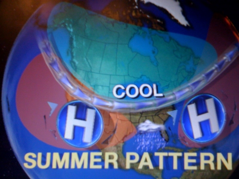
Here on the First Coast we really have nothing to complain about and the one lone tornado report we had on Thursday just west of Brunswick was so brief and weak that it did no damage. We had a few frisky storms with only isolated pockets of 50-60 mph wind gusts despite there being 7 tornado warnings. Yes, we are counting our blessings. The mammatus cloud canopy helped stabilize our atmosphere just enough to keep us out of harm's way. The good news is our pattern is changing and relaxing as we head into May. If you walk outside today you notice the difference. We have a different kind of high pressure taking over our pattern coming from Canada! Yes, Spring is finally here, better late than never after a record 9 days of 90 or above and 5 record highs. We may have dodged the storms but not the heat this month which makes today feel even better!

The old pattern  featured a summer pattern with a Bermuda high set up over the southeast with the strength and intensity we normally see during the summer. You then combine this clockwise flow in the atmosphere that went over the tropical, above average Gulf of Mexico and it provided ample high octane fuel or moisture to developing thunderstorms. This warm, moist air then collided with a jet stream we normally see in January. This added the twist and lift to the storms. The final volatile ingredient was the dry punch of desert air coming in from Mexico and Texas. This made the atmosphere like a pressure cooker ready to explode. The final straw was the daytime heating and upper-level disturbances that tipped nature over the edge. This is why this April 2011 will go down as the most violent weather month on record.

There have been a lot of folks saying May will only get worse. I am thinking we will see an active month but nothing close to what we just experienced in April. Not even close. I will have more on this here on the blog tomorrow along with your May Outlook and what it means to us here at home! See you soon! Thanks for reading.

Festive Spring weather for all the festivals


April 30, 2010

Happy Birthday to my daughter Abbey! I love you and am very proud of you. You make the sun shine brighter every single day no matter what the weather! Abbey is celebrating her birthday today with her church group in Daytona Beach, Florida. She wanted to share this lovely sunrise to give us an idea of what our weekend weather will be like here at home. Wow! Great job Abbey and make sure you keep texting me more weather shots. I am glad you are putting your birthday present to good use! Abbey is our family gymnast and cheerleader and she also is very weather aware. She went to many school talks with me in Indiana and was known to make sure all of our neighbors got to their safe spots while Dad was hard at work with severe weather coverage. Could she be our future family meteorologist? Maybe, no pressure but the sky would be the limit.

Abbey also loves the cooler Spring weather and finally Spring weather arrives on the last day of April 2011 that will be known as an extreme month that felt more like summer with an unprecedented 9 days of 90 degrees or above for us here on the First Coast. It will also go down as the April with the most tornadoes ever on record. To give you an idea of sheer numbers, they are off the charts as you can imagine. We have had 1,020 tornado reports so far which is more than the whole country averages in an entire season. As we finish out April and head into May a new month for us will bring a new weather pattern. I will be back with another blog post on this later this morning.

But let me get you out the door! Today nature finally gets it right for all the festivals from the Blue Grass at Twin Oaks in Brantley County to the Gamble Rogers Folk Fest in St. Augustine. The weather looks great at Fernandina for the shrimp fest and at the Craw fish Fest in Woodbine as temperatures will be right where they should be for this time of year with sunny highs in the lower 80s inland and the middle to upper 70s at the beaches. We will have an east wind at 10 to 15 mph. At the ocean be careful of a moderate rip current risk developing with an onshore wind today. The ocean temperature is now up to 73 degrees with 2 to 3 foot sets for the surfers. The blue fish are biting on the river with a nice light inland water chop!

As we finish out the weekend our Spring weather maker will slowly move off the Atlantic Coast bringing more Spring breezes off the ocean for Sunday with temperatures remaining in the lower 80s. Get out there and enjoy! You have earned it.

Sunday, April 24, 2011

Happy Easter! Find a cool spot for the chocolates!

Happy Easter! We have come a long way from Easter of 2007 when we woke up to 31 degrees.....brrrr! It will go down as one of our warmest Easters on record. Yes, one of the reasons is it falls on April 24th this year. The latest date you can have Easter is April 25th. The date changes every year because Easter usually occurs on the first Sunday after the first full moon of the vernal equinox or Spring. The next time Easter will be this late in the season is 2038 when it will fall on you've guessed it, April 25th. Yes, I guess it all goes back to that Super Moon!

But today looks terrific. It will be our sixth consecutive dry Easter in a row for most of us but be careful of patchy morning fog that will reduce visibilities to less than a mile mainly before 8 a.m. Then expect warm and breezy conditions to develop with highs in the lower 80s beaches to the middle and upper 80s inland. This will be our warmest Easter since 2005 when we hit 88 degrees! The boating forecast looks great with near shore seas near 3 feet with a light inland chop. There could be a stray storm pop along the Interstate 75 corridor today. Better chances of rain moving our way by the middle of next week when the sea breeze collisions occur closer to home thanks to more of a south and southwesterly wind. As a result, this will be the sixth consecutive dry year for most of us on Easter. The dry hopping trail was essential for the Easter Bunny this year especially for my three daughters! They have had a good year and their Easter basket included DVD's, dresses, flip flops and even pool toys! Wow! The Easter Bunny is happy with me too and I got some extra chocolates. Thank you. We do have a lot to be thankful for on this Easter including the weather. Just find a cool spot for those chocolates. Have a great Easter!

Saturday, April 23, 2011

Bright bonnets for Easter but be careful of early morning fog!

Saturday,  April 23, 2011

Sometimes these quiet patterns sneak up on you in Florida with patchy dense fog that can cause big problems especially late at night and during the early morning hours. A persistent flow off the ocean continues to bring in higher humidity and rising dew points. So by late tonight be on the outlook for fog reducing visibilities to less than a quarter-mile. A fog advisory may be needed though 8 a.m. We will keep you updated. This is a concern since we will have a lot of folks up early for the Easter sunrise services at both the Jacksonville Landing and at Jacksonville Beach. Take it easy so you can enjoy the rest of the day which should be gorgeous.


We will have plenty of sunshine and highs from the lower 80s at the beaches to the middle and upper 80s inland. Now we did have a chance of rain which was about 20% for our area. It has now dropped to about 10%. The latest model data shows no rain is expected from St. Augustine to Jacksonville and Brunswick. Areas farther inland where there could be a sea breeze collision could see a quick .10". This would be near the Interstate 75 corridor, including Lake City. Eventually our wind will shift to the south and southwest by the middle of next week bringing those badly needed showers our way. But until then it will feel like Easter in summer. This summer pattern has been with us for about a week and will hold on for a week longer. We will even have a few more days near 90 next week, but at least the heat and humidity will increase our rain chances. Some models are even showing a strong line of thunderstorms moving through on Thursday. Ready for Spring weather again? We will only have highs in the 70s by late next week. But for now you know the drill! Wear the sunscreen and watch for rip currents! Remember 80% of all beach rescues are from folks being rescued from rip currents. Stay safe and have a wonderful Easter!

Friday, April 22, 2011

More meteor showers than rain showers for Easter Weekend!

Friday, April 22, 2011

We are still looking great for our Easter weekend. Nature does try to  make it interesting this time of year in Florida. Even without fronts you have to pay attention to the wind direction and moisture in the atmosphere not only at the surface but in nature's attic. It does look like the atmosphere will moisten up a bit at all levels by the second part of the weekend in time for Easter due to a deep east to southeast ocean flow but it should not be enough to dampen any plans. We could see a brief shower develop Sunday  afternoon and this activity will quickly  move or should I say hop west faster than the Easter Bunny. Temperatures look great once again if you want to take an Easter swim with highs in the lower 80s beaches to the middle and upper 80s inland. But be extra careful while swimming in the ocean. We will see rip currents become more of a problem. Rip currents will be in the moderate range which means only experienced swimmers should go in the ocean more than hip deep. Remember rip currents kill more people every year than tornadoes and hurricanes on average. Take extra caution and break the grip of the rip by swimming parallel to the shoreline and always stay calm.

On a brighter note, we will have the Lyrid meteor shower peaking tonight from midnight to 6 a.m. Make sure to find a nice dark spot. The beach should be the place to be. Make sure to look northeast for 10 to 20 meteor showers per hour. This is almost double our normal amount of shooting stars. Temperatures look comfortable as they will remain in the 60s throughout the night. Have a wonderful Easter and yes I cannot wait to see my family come in from Wisconsin and Grandma from Orlando. I will have more on this and your weekend forecast here on the blog throughout the weekend. Florida is still the place to be!Stay tuned for updates and I have to catch up on some awesome pictures. See you soon!

Thursday, April 21, 2011

Storms look to miss most of us today! Florida the place to be for Easter Weekend!

Thursday, April 21, 2011

Checking out the latest on your only Live Doppler Radar it does look like many of us will miss out on the rain tonight. We are once again going to hit 90 today. This hot weather is playing a part in us missing out on the rain. Not only are temperatures hot at the ground but all the way up into the middle levels of the atmosphere. Yesterday we had a cooler temperatures aloft to work with that helped fire up thunderstorms and even brought nickel size hail to areas like Orange Park. Thunderstorms need this cooler air in nature's attic for storms to occur. Today not only is it too warm but we have a frontal system to our north trying to add more lift to the atmosphere but it is stalling out over South Carolina. This means not much rain will occur with the best chances of rain this evening remaining over interior Georgia and the Highway 301 corridor. The main threats will be lightning and heavy rain. The majority of us will remain dry.

Get used to this dry pattern. Florida is the place to be for Easter weekend. While over half the country will have rain we will be mostly sunny as another area of high pressure builds into the area. This high pressure will bring refreshing sea breezes sooner in the day keeping temperatures much more comfortable in the lower to middle 80s. Eventually this Atlantic flow will bring an increased chance of rain but not until next week. If you are traveling the good news is I do not expect the next severe weather outbreak until next week but there may be a few delays due to all the rain.

I will be back to post some of those incredible rainfall totals and hail pictures from last night. Right now it does not look like we will have a repeat. Make sure to check back!

Wednesday, April 20, 2011

Strange objects falling out of sky in a few areas!!


April 20, 2011

This summer in April pattern would not be complete without a few sea breeze thunderstorms. How about this! We have building cumulus towers her downtown and looking to the southwest these are firing up a few badly needed rain showers and even some thundershowers! I am not expecting severe weather but you can count on a few wind gusts to 35 mph, brief heavy downpours, and lightning. Some areas could see more rain in an hour than they have seen all month long. Yes, strange objects are falling from the sky in the form of rain drops. Here is what your only live doppler radar looks like just to show some kind of proof.


There is also another shower near Callahan. Keep in mind this activity will quickly move west as the southeast sea breeze continues to push inland.  There may even be a strong storm on the west coast of Florida. That will be fun to track on the news tonight. Speaking of rain we do have another rare sight on the weather maps and that is a frontal boundary moving southward with more rain. Now do not get too excited it still looks like most of us stay dry on Thursday but at least a few more of us will see at least scattered showers and thunderstorms. The farther north you go the better chance of rain. This front will quickly lift north Friday allowing high pressure to build in for our Easter weekend. This should keep us warmer than normal and dry!

What is interesting is we are tracking an area of low pressure near Puerto Rico and while I am not expecting it to be a named system this could bring some needed rain to the Bahamas and south Florida and even bring us a few rain showers next week. That should be fun to watch! In fact the overall pattern looks a lot more fun for meteorologists here in Florida and gardeners too. A signicant front arrives next Friday with maybe some heavy duty rain and the latest long-range models for late April into May has a pattern change across the country which would increase our rain chances significantly.

Make sure to stay tuned! Yesterday on the blog we talked about the historic severe weather taking place across the country and I did find a correlation between significant tornado years and an increased risk of tropical cyclones hitting the United States. At this point I am sticking by my forecast of 16 named storms, 9 hurricanes, and 5 major hurricanes. This compares to the normals of 10 named storms, 6 hurricanes and 2 major hurricanes. The tornadoes are a sign that the La Nina is still alive and kicking. These below average surface temperatures in the Pacific usually bring a higher than average number of storms. Another reason for my robust forecast is the sea surface temperatures in the Atlantic are still at record levels, the Gulf of Mexico is much warmer than last year and the barrage of stormy weather over the Midwest and East with lower pressures than average can many times cause unwanted tropical systems to move toward the United States.


Notice the graphic above. This year could be a lot like 2008 when we had similar conditions. That was the year Tropical Storm Fay played havoc with our weather here in Florida and Jacksonville was swamped with flooding. There were 16 named storms, including 8 hurricanes, and 5 major hurricanes. Seven tropical systems hit the United States, including Fay in Florida. So yes, I hope we can somehow get really, really lucky like last year but the odds certainly are against us.  Hurricane season is only 41 days away and it is never too soon to start preparing.

I will talk about more strange objects in the sky here on the blog tomorrow. Yes! The meteor shower is coming and will peak  Friday night. I also will have an update on our pattern change and we will talk more tropics. Chief Meteorologist Tim Deegan is at the Hurricane Conference and I will have a few tidbits to pass along to you here on the weather blog.

Tuesday, April 19, 2011

Bright moon beams and sun rays now but big concerns for hurricane season here at home


April 19, 2011

The nation's oldest city was lit up by the underrated moon last night and notice how colorful the moonrise was. It was beautiful but bittersweet as the lemon drop moon was enhanced by high amounts of dust and smoke in the atmosphere caused by our on-going drought. There is hope on the horizon with a pattern change and better chances of rain. I will have more on this here on the blog and news tonight. We are also tracking more severe weather across the Midwest today. We have had over 14,500 severe weather reports so far this Spring compared to last year at this time which  brought about 4,500 reports. This is a cause for concern when it comes to our hurricane season. I will let you know why with our weather question at 5:30 p.m. and talk more about it here on the blog this afternoon. See you soon!

Monday, April 18, 2011

Gearing up for a week of heat and more shooting stars than rain showers!


April 18, 2011

The drought is really catching up to us in more than one way. Of course we heat the atmosphere from the ground and typically this time of year a southeast flow off the ocean would be more than enough  to keep temperatures closer to normal in the upper 70s and lower 80s. But after a wet start to the year we are running about 2.5 inches below normal since March 1st. Also the main storm track is staying well to our north with more severe weather likely in the Midwest. All these factors mean the heat is on! This dry ground heats up in a hurry and as a result I do think temperatures will top out in the upper  80s to near 90 most of the week. It will feel more like June than April. The humidity will be on the increase and it could trigger a sea breeze thunderstorm the next couple afternoons but right now the main sea breeze collision would likely take place near Interstate 75. I think the most common type of cloud you will see in the sky will not be cumulonimbus or thunderstorm clouds but the pyro clouds you see above. Yes this is the name of clouds caused by wildfires. We have at least two dozen of these going on in our viewing area. Sometimes if they grow large enough in scope and size they have been known to spark thunderstorms but I do not see that happening here at home. Late week will feature a front making a move on the First Coast but it will likely stall to our north keeping rain chances on the low side Thursday and Friday. Easter weekend right now looks like a stronger ocean breeze will kick in but it will remain sunny and dry with above average temperatures in the middle to upper 80s. Yes, so make sure to water the plants and follow any water restrictions in your area.

One other interesting note this week is the Lyrid meteor shower will start heating up as well and peak Friday night into Saturday. I will have more on the blog on this during the week. Look northeast especially after midnight to just before the sunrises. Take care and I will see you soon! Tonight make sure to catch the underrated moon and I will post some pictures here on the blog tomorrow and have a pattern change update and let  you know if it will hold off until after Easter!

Sunday, April 17, 2011

Shimmering sunshine to a Spectacular Full Moon Tonight!


April 17, 2011

Picture-perfect pelican weather is on the way today. Thanks to Tressa Keller for sharing this beautiful photo from St. Augustine. Today nicer weather will swoop in thanks to high pressure. It is the beaches grand opening parade day today and it looks great for all the floats and activities. It will be sunny with a nice light northeast sea breeze moving in. Highs will be in the middle 70s. Inland areas will be in the upper 70s to near 80. This is long overdue in a month that has brought an unprecedented 4 record highs. Not only will it be comfortable but the rip current risk will remain on the low side. Most folks do not realize that rip currents, heat waves, and flooding kill more people every year than lighting, hurricanes, and tornadoes. Just make sure you know that you can still have rip currents even on quiet days especially near piers, inlets, and jetties. Today you can enjoy a nice dip in the ocean after the parade with water temperatures now in the lower 70s. It will be a terrific boating day and a good day to go to the blessing of the fleet at the Jacksonville Landing at 2 p.m.. A northeast wind will be at 10-15 kts. and seas only 2 to 4 feet with a light inland chop. Yesterday it was brutal on land and at sea. We had folks having a tough time just getting in their boats with tropical storm force wind gusts of 41 to 48 mph rocking us and this occurred without any thunderstorms! There were a few trees down across the area including at the big Boat Show at Metro Park. Stephanie Bickers captured wind damage to trees and folks holding on during some of those vicious wind gusts.


We were very lucky even with a few damage reports around the area yesterday. The reason for the relentless wind was the result of what some meteorologists are now calling the Super Outbreak of the 21st Century. This is due to the sheer number of tornadoes over the past 3 days now estimated close to 230 from Oklahoma to Maryland. North Carolina had its most tornadoes since at least 1984 with dozens of fatalities. We stayed on the dry, windy and warm side of the storm and came within one degree of the record high of 90 set in 1972. This monster storm has now been replaced with high pressure that will settle in for the next couple days. This is perfect timing because we have the full moon tonight!


Tonight's may not be the biggest full moon in 18 years like we saw last month but it will be pretty darn close. Tonight's moon is only 941 miles farther away than last month's super moon. I do not think you will be able to tell the difference between this one and the super moon so I am calling it the spectacular moon! Yes it will still be much brighter and bigger than normal and one of our biggest moon's of the year since it is at perigee within 22 hours of being full. Look for a crystal clear moonrise at 7:48 p.m. and I do expect another brilliant red moonrise like Donna Deegan took for us with the Super Moon above. Our drought continues and without a lot of rain to cleanse the atmosphere there are plenty of particulates in the atmosphere to give the moon an extra colorful glow as its light is reflected and refracted many times over before reaching our eyes!


Speaking of the drought it looks like it will be once again catching up with us this week. As our main storm track stays north we stay mainly dry and  look for temperatures to once again take off to near 90 degrees by the middle of the week. Some models are showing a wetter, cooler pattern developing next week but right now I think it is safe to say we may have to wait on thunderstorm and tropical season for our rain to really kick in. So keep on watering and I will keep you updated. The good news is that my long-range outlook for the summer has us closer to normal on rain and temperature thanks to a weakening La Nina and high pressure setting up in Texas. Check out the map below with plenty of hope for us! If you are in the Midwest it does look cooler and unsettled. Send us some of your rain please!


The only concern is the weakness in the atmosphere between the two high pressures will be an increased tropical threat to Florida this year. Tropical systems like to move around high pressure systems and the steering currents do not look very kind to us here in the Sunshine State. It looks like our high risk areas will be the Carolinas, South Florida and the Florida panhandle. This is the total opposite of last year when we had a blocking high pressure over us and it kept the tropical cone of concern over the southern Caribbean as went into drought conditions. It will be interesting to watch. Speaking of interesting, our weather blog question of the day was dealing with those unusual rainbows in the sky on Friday. Here is a picture sent in by Heather Patterson.


It is tough to make out the rainbow colors in this picture but it is a great shot of the halo around the sun that was visible. What folks were really seeing was not rainbows, but a phenomenon called ice halos. Rainbows are caused by sunlight refracting off the back side of rain drops. With halos the sun's light is actually being refracted off ice crystals creating the same prism effect, only the light is going through hexagonal ice crystals which causes the ice halo effect you see in this picture rather than the rainbow caused by rain that arcs across the sky. These high clouds were out ahead of the Super Outbreak that thankfully missed our area and today we will certainly all be counting our blessings. Have a wonderful day and thanks for reading. I look forward to checking in with you tomorrow to talk about the Lyrid meteor shower on the way this week. What a week ahead with a full moon and shooting stars! This is what it is all about.

Saturday, April 16, 2011

Windy record-setting Saturday brings trees down outside of storms!


Saturday, April 16, 2011

It has been a wild Saturday across the South and we are certainly very lucky here at home. A stormy system that has spawned over 100 tornadoes over the last couple of days with several fatalities is bringing us quite a wind storm. We did have an isolated thunderstorm in Georgia this morning and early afternoon but no damage reports were received and it did not last long. The big news is we have had 40 to 45 mph wind gusts in a hazy, sultry afternoon atmosphere as you see at Everbank Field. Reports of downed trees have been received in Mandarin. There are also a couple wildfires that have been whipped up especially in Marion County. The wind is strong despite having no storms in the area because of the intense low pressure moving through the Carolinas at this time coupled with a strong jet stream. Take a look at our saving grace here at home below.


We are talking about a polar jet stream with winds in excess of 140 mph causing massive wind shear and instability across the Carolinas. This was located far enough to our north that it actually helped air to sink over our area which is not conducive for storms. This map also shows most of the deep level moisture in green which is a necessary storm ingredient lacking here at home. Unfortunately, areas to the north were not so lucky and the Middle Atlantic states including Maryland could be next.


We could have used some rain with this system but most areas were shut out. There was one isolated spot southwest of Folkston that had about .50" of rain. Last night you see the impressive ring around the moon that normally brings a 70% chance of rain but as our weather team expected we were only calling for a slight chance of rain south of Interstate 10 and the forecast held true. Speaking of the moon, it will officially be full Sunday evening and behind this wild wind front things will settle down just in time. In fact by late tonight the wind will go calm and the skies will clear. Your weather pick of the week is Sunday with splendid sunshine and highs in the middle 70s by the sand castles and near 80 inland. Water temperatures are more comfortable now in the lower 70s with a low rip current risk just in time just in time for the official opening of the beaches! There is also another phenomenon you can look forward to in the sky including what makes this full moon unsual. I can tell you it is not a super moon but close! I will  make sure to have more on this here on the blog and tube. Stay tuned!

Friday, April 15, 2011

Weekend rain looks more like a spritzel! Do not cancel plans.

Friday, April 15, 2011

Well we do need the rain but it looks like we are going to miss out on most of it this weekend. This means good news for all our weekend plans and bad news for the drought. The main jet stream is just too far north and we have too much dry air in place. If we do see any rain on Saturday it should be confined mainly to interior southeast Georgia in the morning hours.

Expect a strong line of thunderstorms north and west of Tallahassee by 4 a.m. to quickly weaken as it races northeast. Our latest model data has it almost totally falling apart by time it reaches interstate 95 in southeast Georgia. If the storms do find a way to hold together near Waycross there could be a few isolated wind gusts in the 40-50 mph range but for right now our severe weather chances also look to remain small. The Storm Prediction Center has put extreme southeast Georgia in a slight risk so we will continue to  monitor it for you just in case with your only Live Doppler Radar.


 For northeast Florida rain chances look even smaller with most of the activity in the form of a brief rain shower mainly north of Interstate 10.
 
This line will likely fizzle out as it moves into northeast Florida with rain chances remaining on the low side. This front is a big wind-maker so be careful fishing with small craft advisories in effect.There could be some gale force gusts offshore and even near shore wind gusts could be near 30 kts. Sunday looks like the much better boating day with a lighter northeast wind and pleasant sunshine!.

Wednesday, April 13, 2011

From the 3 H's to the 3 C's! We will be wishing for this weather in a few short weeks!

Wednesday, April 13, 2011

We have gone from hazy, hot and humid with a record-setting April to clear, comfortable and calm. We have earned this after setting 4 record highs this month. It looks like this refreshing weather will hang on for at least one more day before the humidity comes back up which will increase our rain chances. We need to enjoy this before our humid season kicks in by the middle of May which is just a few short weeks away. Tonight look for great sleeping weather and ideal radiational cooling conditions. Lows will drop into the upper 40s in southeast Georgia to the lower 50s at the airport. The beaches will be in the middle to upper 50s. Enjoy the bright moonlight tonight which is now 61% illuminated and with the great visibility thanks to high pressure you can check out Saturn and Titan its largest moon!

There is a parade of storms across the country but the main storm track remains well north of our area. As a result, even though there are rain chances on Friday and Saturday it does not look like a huge deal at this point with rain amounts likely staying under .10" in most areas while being scattered in nature. So that is what we like calling a spritzle of rain in the forecast.

I will be back this evening to take a look at just how unusual April has been and what it means for our summer!! Will we see 99 days of 90 or above again? Brb but first I will see you on-air this evening!

Sunday, April 10, 2011

Dog days of April will challenge all-time record record highs for entire month!


Sunday, April 10, 2011

The forecast has gone to the dogs! It was so hot yesterday I had a report of 111 degrees on a car thermometer. Of course this was not official with our hottest temperatures in the lower 90s, but it does go to show you how hot the sun-heated pavement was yesterday. Hopefully you did not forget to put on the flip-flops. Ouch! Keep in mind our forecast temperatures are always shade temperatures taken about 5 feet above the ground in grassy areas. If I was forecasting an actual temperatures taken in the sun, I would absolutely have called for highs near 110 this weekend. So with all the heat out there Peyton Taylor from the Humane Society reminded us not only to find a cool spot for ourselves but for our beloved pets. Thank you Peyton for sending these pictures in showing Barkley staying nice and cool by eating ice to go along with the scrumptious southern inspired dog treats. It was a pawriffic pet social at Confederate Dog Park. We officially hit 92 in Jacksonville yesterday. Today I think will be the hottest day of the entire heat wave with a high of 93. Check out these impressive stats and yes it is one of our earliest heat waves on record!


Normally we have the dog days of summer in July and August and they are named after the dog star Sirius that becomes prominent. But with highs today reaching what we normally would see in July, we can say the dog days have come a bit earlier this year. Yesterday was our earliest 92 degree day since 1967 and something to keep an eye on is the all-time record high for April which is 95 degrees. We will come within only two degrees of this today with a forecast high of 93. The ground is so dry and high pressure is so strong that we could make a run at this record as well today. The hottest April 10th when 90 degrees was recorded in 1999 does not stand a chance. We will smash that CD(modern day version of record)! I can say I do remember listening to Billy Joel records in Elementary School. Now it is all about CDs, even though I do still have cassette tapes....lol. But remember I didn't start the fire, nature did! The map looks scorching below!


How impressive! It is an eye-opener! We have a jet stream looking more like a roller coaster and it will move toward the US-Canada border bringing record highs in the 80s all the way to Michigan. At the same time the sharp trough out west has brought snow advisories to 8 states including thunder snow to Flagstaff. We have had temperature ranges from -2 in California to 105 in San Angelo, Texas this weekend. It does not get any wilder. A least a chunk of the cooler weather out west will move our way. By time it gets here it should modify and be a nice pleasant air mass.

A lot of folks including anchors Deanna Fene and Len Kiese have been worried it is going to stay hot all the way through the summer. At this time I do not see this happening. The hottest part of April is this weekend and we may not see 90s again until May. In 1967 the last time we were this hot this early the summer turned out to be rainy with temperatures below average. So there is hope for not only a cooler summer but drought relief. It was also a year where we had a weak La Nina which matches this year's pattern. Tonight on the news I will share my entire summer outlook. A hint is the high pressure that has brought us this record heat is heading west. This could also mean an increased threat of hurricanes to the East Coast and I will take a closer look at this here on the blog in the near future.


It will be another dangerous day in the Midwest after 19 tornadoes were reported yesterday along with over 360 damaging wind and hail reports. This included an EF3 or greater tornadoes that moved through Iowa. It was their strongest early season tornado in 10 years! The good news is this line of severe weather should weaken considerably as it moves East into our dominating area of high pressure. Notice how the higher risk areas in yellow and red today (above) fall apart by Monday (below).


By time this line moves our way there should not be much left to it by time it arrives late Monday night and Tuesday. It is lacking deep moisture and all the dynamics quickly lift north. At least our rainfall map is still showing a free lawn watering with about a quarter-inch of rain. But, I still cannot promise that everybody will see rain as this front moves through in a weakened state.


So in this forecast today it is all about staying cool and smart in this short heat wave with plenty of pleasant temperatures on the way next week. I have highs in the 70s now for Tuesday through Thursday with more chances of needed rain by next weekend. Enjoy the rest of your weekend and thanks for reading. See you tonight at 6, 6:30, and 11 p.m. with a check on this historic weekend heat wave and more on the relief! So much to talk about and so little time. Thank goodness for this blog.

Saturday, April 9, 2011

Ring of fire pattern brings us the heat and it is here to stay


Saturday, April 9, 2011

Wow, temperatures are quickly rising out there and even though climatology tells us Jacksonville does not average a high temperature of 90 until June 23rd today nature will fast-forward us right into summer. I do think Jacksonville will tie its all-time record of 90 set back in 1978. Find a cool spot and yes a sailboat will do. I think we have a good chance of at least tying if not breaking all the records you see above. So this pattern is here to stay for at least a few days until our high pressure weakens which would not be until Tuesday. We are in what I am calling a ring of fire pattern across the country. The map you see below shows a ring of storms firing up around the cooler periphery of our large scale high pressure system bringing this record breaking warmth.


Since thunderstorms need cooler air to form in the upper-levels that is what you have a ring of fire develop. This is more of a summer pattern that is for sure. What is interesting is I cannot rule out another 1,000 or more storm reports this week with another major severe weather outbreak. Last week we had over 1,400 damage reports, including a record of over 1,032 damage reports in only 24 hours before nature sent damaging winds through our area. This time there will be more tornadoes and they could be the long-track tornadoes especially in the upper Midwest. Watch out Wisconsin and Minnesota, especially by later today and tonight. Then this activity will move east. I think the main battleground should stay north of Florida this time around, but we will still have to watch for fringe effects. We are due for a break after two crazy weeks. I do not expect scenes like this to be repeated here at home like you see in Keystone Heights.


This shed was lifted up and over a fence and there were dozens of trees that were downed in estimated 60 mph to 70 mph straight line winds. Seven homes were damaged all in about a 3 block area. Yes, we have had our fair share of severe weather and the good news is our chances of any severe storms will remain small. Here is how small.


If you are heading to Augusta to see the Masters things could get very interesting with a better than 60% chance of strong storms. Hopefully they do not lose another magnolia tree due to wind damage. Closer to home we could see some fringe effects with maybe an isolated storm firing along the cooler outflow boundary and sneaking farther south. But chances of any thunderstorm activity right now are 12% for Waycross, 8% Brunswick and only 5% for Duval and Nassau County. Since we are shaded in green this means anything that does develop will need to be watched closely with the main threats being damaging wind, lightning and hail. What I think we will likely see is what Lori and her hubby sent me in this morning from the River Walk where the First Coast was kicking it up again today! Great job!


The skies above were filled with debris clouds or a few cirrus clouds that blew off of the tops of 40,000 foot thunderstorms last night that stayed to our north. They brought us a hazy start to our morning. Even though my garden needs the rain it looks like our big story will be trying to stay cool. Make sure to find a cool spot and do not leave your pets in cars. They can heat up over 100 degrees even with the windows cracked in this kind of weather. Also, make sure they have their water bowls filled with water. My hats off to all the folks at the Diabetes Walk this morning here in downtown Jacksonville. Several thousand people made a difference while walking about  3 miles. The Jacksonville Jaguars led the walkers onto Bay Street. Organizers were hoping to raise over 500,000 dollars. As I said on the air this morning I am glad we have a nice weather day and here is another shot confirming it! Wheeewww! The pressure is off!


Stay cool and I will keep you updated throughout the weekend on the air and tube and we will take a closer look at record highs all over the country including who hit 105 degrees and who was below zero!! We will also have an update on another severe outbreak that will impact more than 20 states over the next couple days and what this stormy front will mean for us as it arrives here at home by late Monday night and Tuesday. Our weekend weather blog question will deal with our summer forecast. Is this hot spell a sign of things to come? I better get back to work on this question. See you soon and thanks for reading.

Hottest weekend since September with record-breaking weather!


Record-breaking hot weather is on the way and not just for today. We could at least tie or break all-time record highs through Monday. A strong high pressure in all levels of the atmosphere will be slow to move. The large-scale sinking of the air will heat us up to 90 today and lower 90s by Monday. Humidity will also be on the increase. Make sure to hydrate and wear plenty of sunscreen as the UV index will be extreme. If you are looking for cooler relief head to the beaches where a seabreeze should work in by early this afternoon keeping highs closer to the lower 80s.

There will be a slight chance of a thunderstorm this afternoon mainly for southeast Georgia near Waycross and Brunswick and northward. If a storm does pop it could be strong with wind and hail as the main threats. This is a ring of fire pattern and I will check back with you here on the blog later this morning to talk more about it and why most of us will not see rain until Tuesday.

This nice weather weekend could not come at a  better time...check out the tons of events going on around the area! Get out and enjoy but remember the sunscreen!

Northeast Florida Ride for Kids


Florida State College- North Campus

8 a.m.
Ride for Kids benefits Pediatric Brain Tumor Foundation and includes a motorcycle ride, light lunch, Celebraton of Life program and prize drawings.
http://pbtfus.org/rideforkids/events/2011/northeastflorida.html


2nd Annual Don's FRIENDS 5K Run/Walk
St. Augustine Beach Pier
Run/walk at 8:30 a.m., paddleboard race at 1 p.m.
Includes a new event-Stand UP Paddleboard Race, as well as vendors and live entertainment. See website for details.
http://www.donsfriend.com/dons_run.html


Soldier Ride Jacksonville
Wounded Warrior Project Headquarters, 4899 Belfort Rd
7 a.m. registration, 8 a.m. ride begins
Cycling event for the Wounded Warrior Project. Ends with community picnic.
http://www.kintera.org/faf/home/default.asp?ievent=447720


2nd Annual Setting the Pace for Peace Domestic Violence Awareness Walk
Ed Austin Regional Park, 11751 McCormick Rd.
9-11:30 a.m.
Hosted by Hubbard House. Will include family fun zone, music and more.
http://hubbardhouse.org/


Walk for MS: Orange Park
Orange Park Kennel Club
Festivities begin at 9 a.m., walk at 10 a.m.
Benefit for the National Multiple Sclerosis Society, North Florida Chapter
http://events.jacksonville.com/orange-park-fl/events/show/170786725-walk-ms-orange-park
http://www.nationalmssociety.org/walkMapRegion.aspx


Walk to Cure Diabetes
Jacksonville Fairgrounds
Registration 8 a.m., Walk 9 a.m.
Benefit for Juvenile Diabetes Research Foundation International
http://www.jdrfnorthflorida.org/walk.php


Team Hope Walk for Huntington's Disease
Jacksonville Landing
Registration 1 p.m., Walk 2 p.m.
http://facebook.com/HDSANorthFL


Pawfessionals Pet-Friendly Social
Confederate Dog Park
1-3 p.m.
http://www.facebook.com/event.php?eid=199649250069676


Friends of James Beard Foundation Benefit Dinner
One Ocean Resort Hotel and Spa
6 p.m.
Hosted by Chefs Ted Peters and Nancy Slatsky. Includes chef participant from Bistro Aix, Matthew's and Orsay.
http://www.jamesbeard.org/index.php?q=events_fojbb_atlanticbeach_040911


David Nail with Walker Hayes
Mavericks Rock N' Honky Tonk Concert Hall
Doors open at 6 p.m., concerts usually start around 8 p.m.
http://www.mavericksatthelanding.com/


5th Annual Comedy for Critters Show
Hotel Indigo, 9840 Tapestry Park Cir.
Jacksonville Improv Troupe Hosts Comedy Show to Benefit ASPCA and JHS
Includes silent auction at 7 p.m. Improv show starts at 8 p.m.
http://media.causes.com/1039461

Tuesday, April 5, 2011

LIVE WEATHER BLOG

Picture of gust front as it moved through St. Johns, Florida. Wind speeds reach 40 mph in this area but many folks saw 60 mph wind gusts or higher with hundreds of trees down across the First Coast. Here was the scene in Keystone Heights below. This is a good example of why straight-line wind damage can be just as dangerous and do as much damage as a tornado. Everybody is safe and sound so that is the great news!


8:02 a.m. No more warnings across the First Coast, but we do have numerous problems on area roadways with trees reported down on Baymeadows road and a few reports of power lines down.

7:59 a.m. Significant Weather Advisory issued for Flagler County for 45-55 mph wind gusts

7:52 a.m. Tornado warning has been cancelled for St. Johns County...strongest storm with damaging wind now located over Crescent Beach....

7:48 a.m. Worst storm near St. Augustine still showing rotation but no confirmation that it has reached the ground as a tornado. Tornado warning continues until 8:15 a.m. for Central St. Johns County...get to your safe spots immediately

7:46 a.m. Worst part of the storm now at St. Augustine, just south of Bridge of Lions

7:44 a.m. Severe thunderstorm warning continues for Flagler and Putnam Counties with a strong storm near Hastings

7:42 a.m. Tornado warning continues for Central St. Johns County until 8:15 a.m. with worst part of the storm heading for St. Augustine and St. Augustine Beach by 8:00 a.m. No tornado confirmation but wind gusts near 60 mph likely.

7:39 a.m. Southern St. Johns County near 206 another rotating storm is now showing up on Live Doppler Radar....these areas could also see damaging wind gusts.

7:38 a.m. Most dangerous part of storm that prompted tornado warning now southeast of World Golf Village moving east at 50 mph.

7:35 a.m. No confirmation of Tornado as of yet but dangerous storm capable of producing tornado...it is radar indicated at this time which means circulation is at cloud level and can reach the ground in an instant...please get to your safe spot....Highway 16 and Interstate 95 are the areas of most concern right now and this will reach Anastasia shores and St. Augustine by 7:55 a.m.

7:33 a.m. Live Doppler radar continues to show rotating storm just east of Molasses Junction to the Outlet Mall in St. Johns County

7:30 a.m. There is a bow echo near the World Golf Village...this will likely produce 60 mph wind gusts...sometimes bow echoes can put down brief isolated tornadoes...no tornadoes have been reported as of yet but in this situation you have to  issue a tornado warning due to some rotation in cell that can reach the ground as a tornado

7:29 a.m. Live Doppler radar 2 minute advantage has possible tornado that will arrive in St. Augustine by 7:45 a.m. Seek shelter immediately

7:27 a.m. TORNADO WARNING issued for St. Johns County 15 miles west of St. Augustine for a thunderstorm showing some rotation and it is moving east at 55 mph

(Make sure to hit refresh or F5 on your browser to get the minute by  minute updates on the storms moving through here on the Live Weather Blog)

7:24 a.m. Half-inch hail and ponding of water on many roads...40 mph wind gusts reported in Mandarin and Orange Park

7:23 a.m. Wind gusts of 40 mph reported in St. Johns with heavy rain and lightning....Live Doppler radar continues to stay ahead of radar

7:22 a.m. 60 mph wind gust verified in Arlington...8,000 plus power outages near airport and northside

7:19 a.m. Powerlines down near Commonwealth Avenue as some isolated wind gusts of 60 mph are taking place across the area...

7:17 a.m. Power outages in Dinsmore

7:15 a.m. Thunderstorms have produced pea size hail and 40 mph wind gusts in Middleburg and Arlington

7:10 a.m. Severe thunderstorm warning for Clay, Putnam, Duval and St. Johns County until 8 a.m. Since there is a tornado watch with storms moving through this makes sense but this line moving through so far has had a history of producing wind gusts of 40 mph with lightning and heavy downpours. No local damage reports have been received in around the Jacksonville area so far.

7:10 a.m. Live Doppler radar shows heaviest storms now moving across St. Johns River. Storm track has these storms arriving at the beach by 7:40 a.m. Main threat 40 mph gusts and lightning.

7:06 a.m. Live Doppler radar continues to show weakening line of storms moving through
7:04 a.m. Wind damage has been confirmed in Waycross, Georgia....powerlines and trees down with quarter size hail but this was from two hours ago....the storms moving through our area are weakening....the main threats at this time will be 40 mph wind gusts, lightning, and heavy downpours.

7:02 a.m. Severe thunderstorm warning for Alachua, Bradford, Clay, Marion and Putnam counties until 7:30 p.m.

7:00 a.m. All severe weather warnings have been allowed to expire on First Coast but significant weather advisories likely to be issued with 40-50 mph wind gusts, lightning, and heavy rain moving through.

6:59 a.m. Pea size haill reported in Waldo...

6:33 a.m....A SEVERE THUNDERSTORM WARNING REMAINS IN EFFECT UNTIL 700 AM EDT
FOR DUVAL...EXTREME NORTHERN ST. JOHNS...SOUTHERN NASSAU...SOUTHERN
CHARLTON AND EASTERN BAKER COUNTIES...AT 633 AM EDT...NATIONAL WEATHER SERVICE METEOROLOGISTS AND FIRST COAST NEWS WEATHER TEAM CONTINUED TO TRACK A LINE OF SEVERE THUNDERSTORMS CAPABLE OF PRODUCING QUARTER SIZE HAIL...AND DAMAGING WINDS IN EXCESS OF 60 MPH. THESE STORMS WERE LOCATED ALONG A LINE EXTENDING FROM OCEANWAY TO JACKSONVILLE HEIGHTS...OR ALONG A LINE EXTENDING FROM 6 MILES NORTHEAST OF JACKSONVILLE INTERNATIONAL AIRPORT TO 7 MILES NORTHWEST OF LAKESIDE...MOVING EAST AT 55 MPH.

OTHER LOCATIONS IN THE WARNING INCLUDE BUT ARE NOT LIMITED TO
RIVERSIDE...ORTEGA...DOWNTOWN JACKSONVILLE...TALLYRAND...SAN MARCO...ARLINGTON...FORT CAROLINE...TALBOT ISLAND...LITTLE TALBOT ISLAND...
UNF...MAYPORT...SAN PABLO...NEPTUNE BEACH...JACKSONVILLE BEACH AND
PONTE VEDRA BEACH.
6:12 a.m. We continue watching a line of showers and thunderstorms moving at 55 mph to the east. Right now the main threat continues to be hail and damaging wind. These storms will be in downtown Jacksonville by 7 a.m.

A TORNADO WATCH REMAINS IN EFFECT UNTIL 1000 AM EDT TUESDAY MORNING
FOR NORTHEASTERN FLORIDA AND SOUTHEAST GEORGIA.

5:07 a.m. Line of showers and thunderstorms with wind and hail quickly moving in. Georgia will be the first to be impacted.

Monday, April 4, 2011

Severe threat continues but tornado threat decreasing for First Coast


Monday evening April 4, 2011

We have had an amazing 781 storm reports in the last 2 days. The good news is only 14 tornadoes thus far although the straight line wind damage can be in some cases worse than tornadoes. So even though the headline tonight is optimistic we all still need to be on guard for damaging wind gusts on Tuesday morning. Most of the tornadoes today occurred with daytime heating and tonight tornado chances have gone down to less than 2% based on the latest from the Storm Prediction Center. This number is likely to stay low as a line of storms moves our way. Now if this line was coming through tomorrow afternoon I would be more concerned but as of now it is moving too fast and most of the good dynamics with this system are lifting. Areas from North Georgia into the Carolinas have the most instability on Tuesday morning and then Central and Southern Florida during the afternoon. Yes, here comes the famous split that we often see here in North Florida and South Georiga. But, let's not get complacent. There is about a 15% chance of wind damage within 25 miles of a point from Lake City to Folkston to Saint Simons Island. Then I would lower it to 10% south of that line for the rest of the First Coast viewing area. Here is the timing based on the latest RPM model run.


This model is not doing a great job showing the strongest storms tonight lifting into North Georgia and the Carolinas. The timing looks a bit slow as well. Here is a look at when most of us can see the welcome rain and thunderstorms.


Here we are at 11 a.m. Tuesday and what we will watch for is some bowing segment along our squall line and these areas could bring us our damaging wind gusts. Right now I see most of us in the 40 to 50 mph range on wind gusts with only isolated areas near 60 mph. One thing is for sure we will all have our eyes glued to our only Live Doppler radar. Our team is ready. So recapping everything here are the main threat levels one more time.


The hail threat may need to be increased a bit but for now this should do. Let's keep it this way and get some nice heavy downpours. The latest models are still showing a good .50" to 1" of rain and when I see you tomorrow evening I look forward to bringing you the nice beneficial rain totals with hopefully very few severe weather reports. God bless and be safe! Remember some of these storms will move at over 50 mph and may come sooner than later.

Back to school in summer weather! Stormy late tonight


Monday, April 4, 2011

What a Spring break it was this past week. You see Lauren and I getting ready to go see the fireworks at the Magic Kingdom. She truly is a princess! My family and I enjoyed a wonderful trip to Disney World and we got in all the rides despite record amounts of rain in Central Florida. It felt like we were in a tropical rain forest at times. But the weather cleared just long enough so we could get in all the rides! I would not let it rain on our biggest day that is for sure! I enjoyed the Pirates of the Caribbean ride especially when we went through the outflow boundary out ahead of the thunderstorm before we dropped. What I noticed is there in fact is a lot of weather intertwined in many of the Disney rides if you look close enough. This is the way it should be. Weather plays a big role in all of our lives. The worst ride was the Mission Space ride at Epcot where they have you in a simulator and you blast off from earth and go to Mars. I was rudely introduced to G forces that took my breath and almost my lunch away. It looks like my plan of being a space meteorologist for private missions to space is put on hold for now....lol. I have even more respect for astronauts after that ride. The landscaping also caught my attention at Epcot. When I was younger I never paid attention to such things. But now that I am older I could not get enough of learning about the different plants that actually told a story about the culture of each country we visited. I cannot wait to get back. I hope you had a great spring break and while it was not the best of weather weeks here at home I think you can agree that our parched lawns and gardens are much happier.


Check out the trees all tassled on this sunny side up back to school morning! These tassles will be blowing in a summer wind today with some gusts making it over 30 mph. I made sure the girls had the shorts out for school. Temperatures could rocket up to near record levels in the upper 80s out ahead of the season's strongest Spring storm. Our record high for today is 90 set back in 1974 and we will be close. Let's take a look at where this morning's convection is taking place by using our free weather app that now uses your only live doppler radar data.


Yes, it is a stormy morning in Texas and Arkansas. This is the front that has now brought over 300 damaging storm reports across the country including baseball size hail near Dubuque and damaging wind gusts of 80 mph in Kansas. The Rockies which played baseball in the 80s on Saturday had a game postponed due to snow yesterday! Wind damage scooted all the way across Indiana with damage reported in Williamsport but no tornadoes! There was no surface low pressure to back the winds and this helped keep the wind blowing in the same direction through much of the atmosphere keeping us from having an outbreak of tornadoes. Now a low pressure is expected to develop later today here in the deep south so the tornado threat will start to increase significantly. I expect a QLCS to develop which is a quasi linear convective system or squall line of storms known to produce mainly straight line wind damage but it can also produce isolated tornadoes in its meso-vortices or areas of spin that naturally occur as the cooler outflow boundaries are impacted by the surface friction of the earth. Our main threat remains wind damage here at home but a brief isolated tornado cannot be ruled out since we are going to be located in the front right entrance region of a powerful jet stream.

Timing will be tricky. We could see this QLCS race out ahead of the main front late tonight and reach portions of our viewing area between 3 a.m. and 7 a.m. The Storm Prediction Center has placed us in a slight risk for severe weather. Most of my wind parameters have wind gusts of 50-60 mph with the main line that comes through. Once the storms clear by early afternoon on Tuesday temperatures will only be in the 60s. I will keep watching this for you but the latest for now is that strong storms are still in the forecast late tonight and Tuesday morning. The rest of the week looks terrific including the Sun's home opener. I will head into work to grab a few updated model runs for you here on my day off. Check back this evening for another update.


Last but not least a big thank you to the Presbyterian Riverside Scouts. They had a lot of fun on yesterday's station tour and were so happy with the weather they brought all of us Thank you Berry Munch Girl Scout cookies. I had never had them before and can tell you they are a must try! Dan, Deanna, and I went through a whole box in a blink of an eye and I had to hide the rest from Dan...lol. We went over severe weather safety and these scouts will always remember when the thunder roars outdoors head indoors! We will need to remember this by later tonight. This was the first tour I can remember that had so much fun they stayed for both of our evening shows! They were awesome and to be able to inspire these young smart kids is what makes my job all worth it. Just watch, one of these girls in the picture above will be on television some day, as a meteorologist. I better run, literally! I am going to run 6 miles, then head to First Coast News to get everything ready  for Live Doppler Day on Tuesday. Take care, stay safe and stay tuned. Blog update coming your way tonight! Talk to you soon.

Sunday, April 3, 2011

Blue Skies for the Blues Fest but keep your eyes to the sky by early Tuesday!


Sunday, April 3, 2011

Good Sunday morning! The Sunday morning show was a blast at 7 a.m. I think they should stream the whole show live including what happens during commercials.  I got in another dance lesson from anchor Len Kease. We had a little Snoop Dogg playing and yes I am finally learning to loosen up the shoulders. Today we will be dancing in the streets out at the Blues Fest with plenty of blue skies. You see the breakdown on temperatures at Jacksonville Beach. A sea breeze will move in this afternoon so the warmest part of the day will be early afternoon with highs in the middle 70s. Inland locations will still have no problem making it into the lower 80s. You can also fire up the boat with outstanding conditions. A tame east wind will be at 10 to 15 knots and seas only 2-3 ft. The surf will build from 1-2 feet. What most folks do not realize is that April is actually our sunniest month of the year here in Jacksonville so nature is coming through for us right on cue. We receive 73% of our possible sunshine this time of year. May is in second place with 70% of possible sunshine. Our cloudiest months are December and January. But it is not just our sunny season, April is also a month we have to keep our guard up because it is still technically the peak of our tornado season at least for the beginning of the month. Then our numbers go way down. Here is a graph showing numbers.


By mid-April we transition into waterspout season that can turn into tornadoes as they come ashore and they tornadoes that do form over our warmer summer months are usually short-lived and weak. So let's all get through this first week of April so we can enjoy the rest of the month which does look like it will bring plenty of vintage sunshine.


Here is when we will be in the storm zone. It still looks like late Monday night into Tuesday morning. This RPM model from 5 a.m. Sunday morning holds the main line off from moving through downtown Jacksonville by noon. I think it may be slow especially with the fast flow across the country. Our main threat here at home will be damaging wind gusts. You will have most of your tornadoes with this weather system here in the South taking place in northern portions of Mississippi, Alabama, Tennessee and Georgia. To my friends in Indiana, go Butler, but please make sure to have your weather radios turned on before falling asleep tonight. This is the anniversary of the Super Outbreak that hit back on April 3-4, 1974. So you know what can happen. Here is a picture from the Monticello courthouse that was destroyed.


Am I expecting a repeat. Absolutely not. But I am not ruling out isolated tornadoes moving in from Illinois and wailing sirens by late tonight. Be careful. Know where your safe spot is and have a plan of action. Yes, I still watch out for you and tell Matt Painter he made a smart decision on staying at Purdue. Now it is your turn to be smart. These are areas that will be much closer to the main lift and jet stream causing this severe weather outbreak. What is scary is that many of the tornadoes will likely occur at night. So I hope and pray folks in those areas have weather radios so they can stay up to date with the latest. Here at home we could even see this line race through in the wee hours of Tuesday but it would likely be a gusty line with 60 mph wind gusts. Even though the highest areas of shear and instability remain north of the First Coast this system is so strong we will have to watch it carefully. The good news is the bulls eye this time around is not on us here in Florida. But with that said some areas of Florida could still see damaging storms and we will continue to keep you updated with your only Live Doppler Radar. So today's lesson is we will all keep our guard up.


Our blog question of the day is about the drought. Despite all the rain are we still in a drought? The short answer is yes. We did go down one level of drought from extreme to severe but it is still a big issue as we head through the Spring. Notice we had a solid 1-2 inches of rain to finish March with even 3 " in St. Marys, Georgia but still ended up about an inch and a half below average. We have a slight surplus for the year after being way ahead to start the year.

The long-range models for April are showing the driest weather in Texas and not over us so that is an improvement. Don't get too excited. I am still expecting temperatures once again above average by 1-2 degrees and rainfall to once again fall about 1-2 inches shy of normal. The overall global pattern is working in our favor for increased rainfall by our rainy season so we do have hope especially with a weakening La Nina. I will have more on this here on the blog in the coming weeks. The system swinging through early this week will be a quick-mover so as a result I am expecting rain amounts closer to a half-inch or less. Enough of this rain talk, go out and enjoy the nice sunny Sunday fun day. I am heading to church and will have an update for you tonight at 6, 6:30, and 11 p.m. and of course check back with you here on the blog. Take care.