You can see Lauren and her Pre-School class had a great party. The scary part is they already loaded up on a ton of candy even before they all go trick or treating tonight. I may have to help Lauren eat all that candy. I am all sugared up so watch out! I look forward to heading out to the Mall for the shows tonight. I am still working on my costume. I can tell you there will be a lot of cars flying around and even a cow. That is the only hint I can give you.
Today we will hit 70 as expected. In a typical year our chances of hitting 70 degrees or above is less than 20%. But the percentages are on our side this year and I do not see any monster fronts we normally see this time of year. So enjoy more above average temperatures this weekend with 60s back in the forecast. The pattern looks like something out of August and it is so warm we may even have a pop up thunderstorm this weekend. Wow! I will have more on this tonight and check back with you here on the blog soon. One more tidbit, if you like warm weather soak as much of it up while you can, next weekend will likely bring highs in the 40s with possible snow flurries and it does look like November will turn cloudy and unsettled in a hurry by late next week. For now though all is good. Remember to turn those clocks back one hour on Saturday night before you go to bed and change the batteries in your smoke detectors. Now I had better get some help with my costume. LOL
The answer to yesterday's blog question is below. We actually had a fire-ball type of shooting star called a bolide. We do not have a major meteor shower going on but this weekend keep an eye to the sky for a few more shooting stars moving east to west after sunset until just before dawn. The minor Orionid meteor shower will continue through Sunday night. We average about 6 shooting stars on average per hour and that number could be closer to 10. Happy star-gazing! It does look like the best viewing conditions will be tonight and once again Sunday night. Here are a few more tidbits for you below.
Halloween costume update: I was a tornado tonight!! My four year-old Lauren covered the entire block. Her older two sister had friends they trick or treated with so at least I still have my little Lauren! It was the nicest Halloween I could remember here in Indiana and folks were all in a great mood and it was very noticeable. Julie and I got a thank you note from one of the trick or treaters for the candy. This I have never seen! The wolves at Wolf Park were also in a great mood and it would not be Halloween without a picture and note from Monty Sloan. Enjoy!
Hi Mike,
Tonight we had our Howlloween Howlnight program and the wolves were in a howling good mood J Sorry I could not resist.Here is a photo of Tristan and Kailani, the alpha male and alpha female howling along with the audience.
- Monty -
What a great shot! I was howling over the weather too! We reached 70 degrees as forecasted so I celebrated by dressing up tonight as a tornado. Now some folks have never seen somebody dress up as a tornado. So here is what I did. I wrapped black cloth around me and cut a few small holes in it so I could tie knots with yarn. Of course I attached cars and even a cow on one end of the yarn so when I spun around there would be flying cars and a cow. It was a simple concept that worked really well. A big thanks to our anchor Niccole Caan, Steve Clark in promotions, and Kim Caldwell our morning producer for helping me put it all together. It took a village this year to get me ready for Halloween that is for sure! A special thank you to Gail Huff for the great idea that was called in to me last night after the 11 p.m. show. I always talk to such interesting people not only via e-mail but over the phone and last night was no exception.
Last year I dressed up as "partly cloudy with a chance of showers" but being a tornado surpassed all my expectations. Our Halloween forecast has certainly blown everybody away this year. So I was a friendly tornado that blew in some great weather despite the flying objects around me. But this is a good reminder that we have had tornadoes in Indiana every single month of the year and they are not friendly at all like me. Now enjoy a weekend forecast that will blow you away and I will post a few more pictures here on the blog that sum up what a wonderful Halloween it was and our great start to November! Make sure to check back.
Saddle up, we have a real winter coming our way Lafayette!
Here is what you have all been waiting for! This is your updated winter weather forecast below. I have upped my original snow forecast originally close to 20 inches to a total of 24 to 28 inches. Temperatures also look colder than last winter, although overall slightly above average.
This is based on abnormally thick snowpacks across all of northern Russia, most of Alaska, and northern Canada. The ice sheets are in the best shape I have seen in years. The sun continues to be unusually quiet and the lack of sunspots could certainly have an impact on our winter. The fewer magnetic storms or sunspots usually correlates into less solar energy reaching the earth causing colder weather across the globe. Volcanic eruptions in Alaska and around the globe are once again on an upswing. These particles tend to block out sunlight and have a cooling effect. The Pacific and Atlantic Ocean temperature profiles favor winter weather we saw in the 1950s through the 1970s, not the unusually warm period of the 80s, 90s, and first part of this century. London recorded its heaviest October snowfall since 1922 this week. Alaska had its earliest start to winter since the 1980s and has already recorded a mercury-freezing low of -42. That was the actual air temperature!
So all of these factors above will factor into our winter forecast. What does this mean in terms of snow? Let's take a look at the chart above. Last year we pretty much doubled our average snowfall of 22.4 inches in Lafayette with a whopping 40 plus inch season. This placed it in the top 5 of all snow years dating back to 1906. It also set records for rainfall and thunderstorms. It was the stormiest winter on record hands down. You can see why below. Notice the main storm track was the Texas Low track that swung right through the Ohio Valley. This is the track that gives us our biggest storms. Since the Bermuda High was to our East and a stagnant high pressure to our West. This meant we were right in the storm zone.
The only reason I am not going for record snow this winter is the main storm track has changed. The La Nina is now gone and we have about average temperatures in the Pacific Ocean. This means the main player this year will be the Atlantic Ocean and a blocking high pressure expected near Greenland. This bends the jet stream in a position that brings paralyzing nor'easters and even blizzards to the East Coast. Take a look at this year's winning storm track.
I will make some calls to friends and family back in Maryland that is for sure. I am ready to organize a blizzard party. Now how about temperatures. This is the tricky part of the forecast. Logan Johnson (state climatologist extraordinaire) and I both agree winter will come on fast and furious this year. I like a possible record snow by late November. December looks like silver bells, jingle bells, and kids singing in a winter wonderland with plenty of cold weather and snow. The atmosphere is still remembering the stormy La Nina pattern from last winter and is having trouble moving on, even though we are officially in a neutral pattern. This favors a snowy start to our winter.
I do think nature gets on with its life as we move into late January due to the LA NADA effect or near average Pacific ocean temperatures. So we could thaw out in a hurry and it is the only reason I went with slightly above average temperatures.
But remember nothing is set in stone. The Pacific Ocean is in a cool phase and the question is if it will totally snap out of the La Nina-esque pattern by later in January and the remainder of our winter. If we have a lot of snow and it stays on the ground that could change things and storm tracks. This still means we could go down with one of the snowiest and coldest winters on record without a doubt. The first paragraph above gives many reasons how a forecast of slightly above average temperatures could go to way below average with even more snow possible than the 24 to 28 inches. Time will tell.
I like the looks of 3 big snowstorms this year for Lafayette! For now the Climate Prediction Center has us with equal chances for normal snowfall, below normal, and above normal snowfall. So that is of no help. At least I stuck my neck out there. It is the only way to truly be a forecaster.
The Climate Prediction Center also has us in above average chances for a warmer than average winter you see above but again there is a lot out there working against this. To my relatives in Wisconsin....just be ready for some bone-numbing cold and snow. The chart above really is too good to be true for warmer weather lovers. I do not see Milwaukee back over 100 inches of snow like last year's record-setter, but a good 50 to 60 inches of snow or slightly above average snow is looking good with Osh Kosh, Wisconsin seeing even more.
HAPPY SNOWMOBILING! The Alberta snow track will be very active this year and a little farther north than last year. This includes the Upper Peninsula of Michigan. Are you ready for winter? I am now! We will all keep blogging and prepare for nature's fury. This will be another fun winter, that is for sure! Get the cameras ready and start stocking up on shovels and other supplies.
Today's blog question: What was that bright object streaking across the Lafayette sky at just after 9 p.m. last night?
I will have your answer shortly. Now I had better go calm down some Marylanders and Cheeseheads up North. Word travels quickly once I type things out on this blog. In the meantime take the pumpkin-carving outside this afternoon. It will be a classic autumn day!
Hey Mike, with Halloween being only 3 days away I thought I would send you a Halloween picture of Willie my sisters Chihuahua and My Rat terrier, Dobby,
Happy Halloween!! Justin New..... Thanks Justin, your Chihuahua should have been in Beverly Hills Chihuahua. Willie would have stood out from the hundreds of chihuahua's in that movie. My daughter's and I loved it. It is a must see along with your great picture above. Dobby is sporting a great look too!
Weather Headlines: We are Going from a Dog Eat Dog Weather Pattern to A Doggy Dog Delight!
Lafayette dogs were not the only ones ready for GQ magazine. The Williamsport dogs are all fired up for Halloween! Here is a picture sent in by Sherry Morrison. From left to right you have Gracie, Misti, and Jenny! Those look like the friendliest witches I have ever seen. Definitely those are good witches you see above.
There is no better place to be a meteorologist than Indiana. If you are looking for variety and great weather to track there is no place like home. A good example is this week's forecast when we will go from lows in the 20s and then have highs jump to the 70s within 50 hours like we will see from Wednesday morning to Friday afternoon. We have real Indian summer on the way! Check out the official definition on dictionary.com.
Indian summer: "spell of warm weather after the first frost," first recorded 1778, Amer.Eng., perhaps so called because it was first noted in regions inhabited by Indians, or because the Indians first described it to the Europeans. No evidence connects it with the color of fall leaves or a season of Indian attacks on settlements. It is the Amer.Eng. version of British All-Hallows summer, Fr. été de la Saint-Martin (feast day Nov. 11), etc. Also colloquial was St. Luke's summer (or little summer), period of warm weather occurring about St. Luke's day (Oct. 18).
The meteorological definition is one that talks about a warm spell usually more than 10 degrees above average after a hard freeze. A hard freeze is when temperatures drop to 28 degrees or lower. In addition, our average highs drop into the upper 50s as we end October. We certainly meet the criteria on both counts.
Yesterday you can see signs of the Siberian Express in the Lafayette sky above. It has charged our way with a strong northwest flow this week. You see the cirrus clouds blowing in from the North. Lucky for us it is not January or highs would have struggled into the teens with lows below zero. It could have been a whole lot worse. At least the early bird voters that went to the polls yesterday did not have to fight up to 20 inches of snow that fell near Utica, New York! We took our own early bird weather poll yesterday of folks ready for a warmer change. Do you want four more months of this? Check out who won below.
It was a landslide and it looks like the majority will get their wish without a doubt. In fact, we have better chances of thunderstorms over the next 7 days than snow. As fast as gas prices are falling the temperatures are rising! At least the colder weather and snow fans got some quality time in before the warmer changes move in. Julie Krizen our reporter from Sarasota, Florida was amazed at the light dusting of snow she found this morning before work. She even made a little snowball. This of course was more like a few squished snowflakes that were the size of her pinky nail, but by Florida standards we will give her credit for making a snowball. This is something she has only been able to do a couple times in her entire life so she actually may have been more excited about the snow than I was which is saying a lot!
I plugged in numbers to the homemade WLFI forecast model and it actually likes lower 70s for highs on Friday. So no more talk of snow for now. Somebody told me today we are the only television station forecasting close to 70 on Friday. This is the way I like it! It is just another reason to watch WLFI and as I always like to say the weather really is much different than Indianapolis and we plug in totally different numbers than they do thanks to our local weather watchers, cloud and wind observations, precipitation amounts, WEATHER BLOGGERS, etc. It is a team effort. We appreciate your trust and viewership. I may run hard in marathons but it is nature that pushes me the hardest and it is what makes this job so much fun!
Our new web-site was launched yesterday that now includes LIGHTNING TRACKER but keep in mind it will take another good week before everything is up and running so the weather ticker will be added along with our paragraph of weather which will include your local forecast focus. For now the 7 day forecast to look at or really believe would be the one on our wlfi.com home page with the nice blue background. The text 7 day forecast on the weather page is not done by us and this will change by Friday when we will manually update it by hand with some text added. It is another example of how the dot.com companies do not work too well when it comes to forecasting the weather. We will also start adding video web weather again ASAP. Please send any other thoughts and ideas or feedback my way so we can truly serve you. You are what really matters. If you are not satisfied either am I.
Have a great day. I am putting the finishing touches on the winter forecast today and will have the latest on how our local forecast will be much different than what is coming out of the Climate Prediction Center. I used some of their thinking as a guide and then fine-tuned it with our local weather data to come up with a much clearer weather picture. We were talking snow before Halloween and got it....now I am talking about a 95% chance of a White Christmas. Our winter is being called a La Nada which means "nothing" but it will have a whole lot of "everything". I will let you think about it and have the dogs chew on it until tonight's newscast. I look forward to seeing you here on the blog first thing on Thursday!
Well of course I am awake because Springville in La Porte County Indiana has just reported its first inch of snow of the season. Were any of the models showing this? No, but remember they are only guides and we knew tonight on the newscasts we would have another nice lake plume developing with possible light accumulations on the grassy surfaces in far northern Indiana. So like I should have done Friday night in the wee hours of the morning I threw out the models and went with latest satellite, radar, temperature, and pressure trends. You cannot go wrong by going back to the basics. The human element always wins out in my book. Every once in awhile you get a nice reminder. Tonight I stuck by my forecast, literally, and sure enough down came the sticking snow in La Porte County! The news was not all good with the first vehicle slide-off of the season also reported. Here in Lafayette there was also plenty of excitement. While we did not have any snow accumulations, for the second night in a row we had reports of snow flurries. This time I had my camera ready and snapped some of Lafayette's first snowflakes of the season above. This is a picture from just after 8 p.m. on Monday right after I walked the dog. This is also verification of Justin's report that came in at about the same time. My dog B.J. wasted no time and taking care of business in record time and I did a marathon sprint into the house to find a camera. My family has never seen me move so fast! But there is the proof above. I knew all the running I do would come in handy someday. Here are more reports of snow that came in just after 12:30 a.m. Tuesday morning on radar.
Areas from Delphi to Logansport and Winamac and stretching over to Kokomo tonight are getting in on some of the flurry fun. We also had some interesting e-mails of sleet being reported. Check it out.
In Tipton, we have had a nice period of sleet....light sleet, but it lasted 25 minutes....accumulated, very briefly for about 10 minutes on the streets and sidewalks....we heard it on the roof!!!
We didn't see any snowflakes....but that will come soon enough.
I am curious about the winter ahead....I am interested in the lack of solar activity....what will that bring?!? If anything???? I am ready for a winter UNLIKE the last one...more like 2006-07!!!!
Chris Thanks for the great report Chris. Today I am heading to the Indianapolis National Weather Service Winter Workshop which is coordinated with all the television stations in Indianapolis along with emergency management. I will make sure to ask about the solar activity on the sun and if it is possible it could impact our winter this year. I remember a few years ago a very active sun was one of the reasons I truly believe we went from a forecast of a snowy winter to a snowless one. This year things are favoring more snow due to a lack of sunspots. It should be interesting! I know Upstate New York is thinking it will be a snowy winter as they are being buried under 6 to 12 inches of snow over the next 36 hours. Check out our snowcast below.
Is it a sign of what we can expect this winter? I will have more answers for you tomorrow here on the blog with a re-cap of the winter conference. Today though keep out the layers and make sure the kids have hats and gloves at the bus stop with wind chills near 20! Halloween still looks like a treat with dry weather and 60s on the way so keep those warm thoughts. Have a great day.
Yes! I did see my first snowflakes along with other Lafayette residents last night. I was a the LAGC state gymnastics meet in Noblesville. The Lafayette team and my Abbey did a wonderful job! Abbey shows off all her bling and gives her patented big salute! Miss Cindy even treated the girls to a little ice cream. What a coach! During our little dinner break is when the excitement hit. We saw a few fluries in our headlights. I checked with the other parents to make sure I wasn't seeing things, especially after all our model runs were showing less than a 10% chance of it happening. But I know you never say never in Indiana and I was loving life after those flakes starting coming down. The wind was even more vicious and added to the excitement. On the way home last night we also saw flurries on Interstate 65....Zionsville exit...Lebanon exit....Frankfort exit....the Dayton exit or first Lafayette exit. Our director Allie saw a few flurries in Lafayette at 2 a.m. last night while carving pumpkins! Today a few more snowflakes were reported across Jasper, Pulaski, Rochester, and Miami Counties thanks to the lake-effect. Now the big story tonight will be a freeze warning in effect with perhaps a few flurries. I will check back shortly and talk more about this including the wind damage reported in Chicago. Yes, a hot chocolate advisory is still in effect. Blog on to stay warm!
Wow! Look what I found from the C-MAN station in Michigan City. This is basically a fancy word for a weather station located on one of the three lighthouses at Michigan City. There was a 71 mph wind gust at 6 p.m. While I did not find any pictures from Michigan City the National Weather Service in North Webster shared this picture from Diana Pickering with us. This was taken not far away at Silver Beach in Michigan. That is one angry wind and a cold one too! Look at our weather watcher highs for our Monday.
These are temperatures we would usually find in late November and early December. The wind certainly made it feel more like December. Wind gusts hit 37 mph yesterday and today they were howling between 20 and 30 mph.We did have a report of 3 foot drifts....leaf drifts that is from Mark and Madelyn our weather watchers in Kokomo. It may be some time before we actually can get outside and actually get some good raking done. Our wind speeds will stay up for much of the week. We may see enough high pressure nose in on Wednesday afternoon and maybe some lighter winds moving in for later Saturday and Sunday. But remember the wind is a sign of the battle of seasons that takes place this time of year and it looks like autumn and winter will continue to fight it out for the next several weeks. The bigger your temperature changes on the weather map means you will inevitably have big pressure differences causing the wind to speed up. So it is the time of year Indiana is known as "Windiana". Batten down the hatches, we have only just begun.
Here is the big weekend weather update you have been waiting for! After receiving .53" of an inch of rain here at WLFI we no longer have to worry about any more rain. This is perfect timing with the Purdue Homecoming taking place today. Maybe our Boilers can pull off a win and get on a roll. If you are not going to the game you may want to take a nice drive as the fall colors are peaking around the state of Indiana. The skies may stay on the gloomy side today but the trees will more than make up for it! We should also have good camping weather as well and it is looking good for trick or treaters at Turkey Run State Park. Now how about the snow? Well, our chances have gone down to less than 10%. Notice I did put our snow concerns very low on the chart above and for good reason. There just will not be much moisture to work with the cold blast moving our way. The air mass arriving Sunday night is arctic in origin and is bone dry so I broke the news last night at 11 p.m. that most of us will likely not see any snow. It was a tough thing for me to do but none of my models including the WLFI model were holding out much hope. The snow chances may have fizzled but the arctic air mass is gaining steam. Look at those 11 p.m. temperatures last night up in Alaska and northern Canada! Ouch!
These areas above in the single digits, teens, and 20s have plenty of snow cover on the ground. Alaska has had its coldest and snowiest start to autumn in decades and this has allowed an awfully cold air mass to build up to our north and it will get a good push our way by a strong jet stream. It will feel like December here at home by late Sunday night and Monday. The other boot is about to fall!
A 30 degree fall in about 8 hours is quite impressive, but not as impressive as the wind storm about to hit our area. Expect 40 to 45 mph wind gusts Sunday afternoon and early evening ahead of our arctic front. The wind speeds at jet stream level will be up to 125 mph. Now that is what I call the Siberian express. The wind will still be gusty by Monday morning taking wind chills down in the teens so remember to wear the layers. The good news is this rough stuff will be out of here by time the kids trick or treat next Friday with a nice warm-up. It should be quite a treat but for now get ready for a December trick up nature's sleeve. Have a great weekend! Take care.
My name is Barb Meihls. I took this photo in our back yard when our grandkids came over to play in the leaves that Grandpa piled up for them. This was taken October 18th. In the leaves all you can see are the faces of Hunter, Jonathan, Hayvn, and Madison.
Thanks Barb! Happy Fall Break to all the kids, grandparents, and parents. I do know that many folks that go on trips this time of year are staying closer to home or having a staycation. This means the weather forecast is more important than ever. If your kids or grandkids are anything like mine they absolutely need to get outside and burn off some energy or else it can get ugly in a hurry. I am already in the dog house with my wife over this talk of snow and she will love that rain is in the forecast for the kid's first day of fall break. But I have some good news. I still think the kids can get outside for most of their fall break. Just make sure they are bundled up on Monday. Today though does look more like a bowling day. You can see why below. We have storm Stefanie spinning our way. Yes, we named our third big storm Stefanie. Yes, Justin's names were very creative but Stefanie got the most votes and it is in honor of our new morning meteorologist Stefanie Davis who is doing a great job! This was Teri's idea and a great one I might add. We do need to start naming storms after some of our bloggers as Brow suggested. If we are naming a storm after one of our weather team's members it better be impressive and the good news is that it is! Wow the picture below looks like an inland hurricane!
As impressive as this is Stefanie is actually weakening as it moves into Indiana and as it moves east it will wrap plenty of dry air up into our neck of the woods. So today even though we may start with some steady rain on our Friday I do see a break in the rain by late today and this evening with only an isolated shower possible as a dry slot works in. This means there will only be one or two blips of green on Live Doppler 18. You could even take the kids to the Boo at the Zoo that so far has rave reviews. We have had great luck on Fridays for the past 10 weeks for high school football and tonight is no exception. The graph above does show one more round of rain by late tonight and first thing Saturday before we dry out for rest of our weekend. So all in all Stefanie will go down as a dynamic and friendly fall storm. I wanted to give a special shout out to my youngest daughter Lauren who prepared for Stefanie's arrival by sweeping out the Prangley garage.
She did this all on her own. I was in shock when I asked her what she was doing with a broom twice her size. She said she wanted to clean the garage for me and my 4 year old did this for about 30 minutes. This is in stark contrast to her other two sisters. I better not go there, but I love them just as much! Lauren was very excited when I told her about some snow on the way for Sunday night. She screamed with joy when I told her about frost last week but in my book this tops that by a mile and it is another good example of how my 3 girls are always keeping me on my toes and the good news is that sometimes even means some very pleasant surprises!
Speaking of surprises.....the talk of the town was not just the lower gas prices but the snow your local weather team has been talking about. If you are a regular blog reader the snow in the forecast should come as no surprise. We have been talking about possible snow during the last week of October for at least the last couple of weeks. So if this does happen you better believe I will be very proud of this. Being a meteorologist in the Midwest is always humbling and it is just nice to see things work out as planned. Nothing is ever taken for granted that is for sure. I will be up all night until I see that first flake of snow fall on Sunday night and early Monday. I will not need coffee that is for sure. I am not the only one excited. Stefanie came into work with me yesterday afternoon despite being up since 2 a.m. She has to get up that early to prepare for our morning show that begins at 5 a.m. She certainly did not look tired when she came in yesterday as you see below. She could not believe I wanted to take her picture for the blog, but I explained how important this is to you and what our bloggers mean to us! Thanks Stef!
There is our newly designed weather set and that is not the only reason Stefanie is smiling. She brought in her lap top computer and we both went over BUFIT data in detail. BUFKIT is a forecast profile visualization and analysis tool kit developed by the staff at the National Weather Service (NWS) office in Buffalo and the Warning Decision Training Branch (WDTB) in Norman, OK. As of January 2001 it is in use in over 75 NWS, Department of Defense, University, and Environment Canada locations. Basically BUFKIT helps you fine-tune details of a forecast and it is a great guide for snow forecasting. Well, let's see what we found!
Yes!! This is when I did a lap around the studio yesterday! Our weather team found a blue bar which indicates snow flurries. You see it pops up just before 12 zulu on Monday morning which is actually Greenwhich Mean Time. So if we get the snow it would likely be very late Sunday night and early Monday morning. I still would not rule out a few lake-effect snow showers around the area during the day Monday. We would also have another chance early Tuesday with BUFKIT showing some deeper moisture in place to go along with our first arctic air mass of the season.
Excitement is in the air and fall break may feel like winter break for many kids by Monday but that is what Indiana is all about and why I love living here. We will keep you updated and I really mean that. Prime example number one...I am not even close to tired and here it is at 1:22 a.m. and in strolls our weekend forecaster Brian Wolfe all fired up about the weekend and winter forecast. We just went over some Skew T's which are also known as a meteorologist's weather bible. We will have quite an impressive northwest wind on Monday morning and they are showing enough moisture in place to squeeze out some flurries. Yes! Not to boast or sound like a promotion but I do not think any other weather staff compares to the one we have at WLFI when it comes to sheer or should I say "scherer" enthusiasm and work ethic. Of course we are also very grateful to have Steve Scherer on our staff and when there is anything big coming you better believe he will be here. I am surprised I have not seen Steve yet!
Your winter outlook is being put on hold due to new developments and due to storm Stefanie and the impending flurries. Think of it as a snow delay. I can tell you I still see plenty of cold weather here to stay by Thanksgiving and continuing through the holidays with plenty of snow. The New Year may bring a new warmer pattern but this may be less fact than fiction based on some new long-range indicators. More on this here on the blog next week. I will most likely check in with you this weekend with a snow update. Who else would I chat with all night when snow is in the forecast? I HAVE BEEN WAITING ALL SPRING, SUMMER, AND FALL FOR THIS....okay I need to pace myself. HAVE A GREAT DAY AND LET IT SNOW!!
Television is all about being informative and having fun and last night I found that happy balance with Virginia the possum at Columbian Park. Talk about animal interactivity! It was the first time I have ever held a possum and I liked it much better than the snakes Claudine Laufman, the Columbian Park Zoo Director scared me with a couple years ago. Virgina the possum was one of my best interviews ever and is taking part in the always fun Boo at the Zoo going on once again tonight and Friday night from 6:30 p.m. to 9 p.m. All proceeds go to benefit the Friends of the Columbian Park Zoo which in turn helps to bring new and exciting animal exhibits to your hometown zoo. Do not forget about the wonderful train ride with tons of fairy tale skits ranging from Little Bo Peep to Humpty Dumpty and the Three Little Pigs. The weather looks great for today and this evening if you are taking the kids out for some fun on their fall break. Speaking of fall....autumn will play possum today as we warm up into the lower to middle 60s this afternoon but do not let that fool you. The warmer wind is a sign of a big storm brewing. This storm has a little bit of everything associated with it from strong thunderstorms and heavy rain to heavy snow that has blanketed Nebraska with several inches of snow. We will be on its warm side today but it also has a cold side as you see below.
Notice, I made sure to do a nice fly into the storm last night during the weather to show what it is capable of and of course our weather flight ended in the heart of a heavy snowstorm! While this storm should bring us mainly rain its backlash will bring us a chance of snow flurries by later Sunday into early Monday. Stefanie Davis, our new morning meteorologist will be watching the models with me along with the new Bufkit Data. We will make sure to give you an update. I am sure I will also be hearing from our weekend forecaster Brian Wolfe who absolutely loves forecasting snow. I have never been on a weather team where all 3 of us absolutely love snow and winter forecasting. This will benefit us greatly in the next few months as we will not let any details go uncovered so you will not have any surprises! It should be a lot of fun and since we have so many winter weather enthusiasts here on the weather blog you will play a big part in this as well with all your stories and pictures you send in. It will be a team effort that is for sure and should go a long way to keeping everybody prepared and safe this winter so we can enjoy that winter wonderland to its fullest. The woolly bear caterpillars are ready and this one I named Warner has his forecast completed!
Check out this dark woolly worm a viewer brought in before my shows yesterday! I took Warner the Woolly Bear home last night and I never have seen Abbey or Megan move so quickly. They were terrified while Lauren was more inquisitive about where he came from. You should be scared if you do not like a lot of snow or cold weather because Warner is telling us we will have a cold and snowy winter but please try not to scream at me like my girls did. My ears are still ringing and this time around I can blame Warner. I will have to get you his e-mail address. But seriously, tonight you will need to tune in for the latest Climate Prediction Center winter forecast along with my updated winter forecast. Is the woolly bear onto something? So far I have not budged, but I remember telling you nothing is set in stone. I will see you tonight with the latest. The wolves at Wolf Park are also excited about winter as well. They love the colder weather. Tristan the wolf is howling his approval below at a recent Howl Night. Monty Sloan always adds the perfect touch to this blog!
We will have howling wintry winds with west northwest winds gusting to 35 mph and actual air temperatures plummeting into the 30s Sunday evening. Five-thousand foot temperatures will fall to 21 degrees at 5,000 feet. What is significant about that is that you usually want those temperatures to be at 27 degrees or lower for snow and we certainly have met that threshold. The biggest thing I am watching for is available moisture. The atmosphere will start to dry out pretty quickly on Sunday night but I think we should have enough lift with the very cold air mass coming over the much warmer Lake Michigan to produce at least a few lake-effect flurries. So do not worry if you see me at the grocery store today buying milk and bread. It is only because we are out of those things at the Prangley house and nothing more. There will not be a big snowstorm and I will not need my golden shovel to help you dig out! I almost started a riot a couple times last winter at the grocery store after some folks saw me buying bread which they took as a sign they would be snowed in. Lauren is still antsy about going down the bread aisle with me. She has her Dad's memory that is for sure. I will make sure to post the latest winter outlooks here on the blog this evening and talk more about our third major autumn storm of the season. We need a female name to the storm that will bring a half-inch to about an inch of rain. So make sure to send those name ideas in and I will get to work on your winter update. Have a great day and remember you can do anything you set your mind to.
Long-range tidbit: We will have at least two more warm spells or Indian Summer conditions as we head into November, but once things turn cold just before Thanksgiving it will be here to stay through the end of the year. Our chances of a White Christmas remain at 80% instead of our normal 50-50 chances. The postcard winter picture sent in this week from George Slavens of the snow that hit the area on January 8th will likely be what you see for the holidays which may even include Thanksgiving. I have not backed off my forecast of a possible record snowstorm in November for Lafayette one bit. Thanks for reading and go soak up some sunshine while you can!
This was the scene this morning at Congress Street United Methodist Church where there was frost on the pumpkins. We had our coldest morning since April 15th and as forecasted most of us had a freeze last night. Here are a few of those impressive lows! Professor Boots the famous WLFI blog cat had the right idea last night by staying warm near the fireplace.
Notice how one temperature sticks out like a sore thumb. That is right West Lafayette where Lafayette's official temperature is taken actually did not reach freezing. This was caused by an east wind at 5 to 10 mph that set up throughout the night. This wind flow blowing over the warmer city of Lafayette before reaching the official thermometer down wind (concrete and buildings hold heat) caused a heat island effect. This is a warming effect on the atmosphere near ground level and it is greater at night than during the day. It is also more noticeable as we head further into autumn and winter than it is during the summer months. It has messed with our forecasts here at WLFI more than once. I notice it more when we forecast bitter cold air masses. Some areas hit well below zero while Lafayette is several degrees warmer. The wind direction here is key along with all the man-made objects. Just something to think about.
Regardless, it still wasn't a killing freeze last night. This happens when air temperatures reach 28 or lower so the mosquitoes are not done with us yet and I do think we will see at least two more warm spells before real winter sets in. No sign of warm weather though tonight. It will not be the temperatures as much as the wind chills as they fall into the middle 20s. This will make it feel like the coldest night of the season. I look forward to heading to Columbian Park for the start of the Boo at the Zoo and will be wearing my layers. It wouldn't be a Boo without a few chills!
At least the rain will hold off until Friday. So off to the train ride I go and I will check back in with you soon and we will take a look at our snow flurry chances Sunday night into early Monday. I do not think we will need the snow shovels but we will get a little taste of winter. Have a great evening or should I say a bootiful one!
I took this picture at sunset this past Saturday (10/18/08) at the Jasper/Pulaski County Game Reserve. Every fall large migrations of sandhill cranes stop over at the reserve. There are few if any places in the U.S. where you can see larger groups of these impressive birds. Each evening around sunset the birds all congregate in the same marshy field. By the end of October, as many as 30,000 cranes will be there before they start their trek to Alabama and Georgia.
Bernie Chamness West Lafayette
Thanks Bernie! These beautuiful birds have been spotted heading south through Monon, Brookston, and Lafayette. Not only are they easy to pick out because they are large but their loud honk is unmistakable. Now we may have some snow and cold air migrating south next week based on the latest model runs.Thanks Bernie! These beautuiful birds have been spotted heading south through Monon, Brookston, and Lafayette. Not only are they easy to pick out because they are large but their loud honk is unmistakable. Now we may have some snow and cold air migrating south next week based on the latest model runs. Tonight I think many areas could have their first freeze of the season. It all depends on how quickly the clouds move in. I do think the clouds will be delayed into our area thanks to an area of low pressure to our west cutting off from the main flow.
Notice our area of low pressure is caught between two jet streams with nothing to really push it along. This is why these cut-off lows are very slow-moving and the latest models not only hold off the thicker clouds for us but the timing of rain until at least late Thursday and more likely Thursday night and Friday. So bring in Professor Boots and all the cats and of course B.J. and all the dogs along with your sensitive plants tonight. I will detail those lows tonight on the newscast. This is a sign of things to come as you see below.
We are in a highly amplified pattern and this meriodonal flow will only become more extreme next week as a ridge of high pressure builds out west. This will allow a real good chunk of arctic air to pour south. Our highs will be stuck in the 40s it looks like by Tuesday and Wednesday with a few lake-effect snow showers possible as far south as Indianapolis! Some maps have chances of snow all the way to North Carolina.
This is a reminder to look for the Golden Snow Shovel contest on wlfi.com which will begin this week. Tell us when you think the first inch of snow will fall at WLFI and you could win a free year's worth of pizza from Mad Mushroom. Now next week our chances of seeing that first inch remain low, but the first few flakes of snow should get you fired up for this always exciting contest. It is hard to believe it is already our third year doing this and I already have my golden snow shovel ready! A huge thanks once again to Mad Mushroom Pizza.
Before I forget I also wanted to do a big shout-out to all the Lafayette area runners this past weekend that I spoke to and ran with in Lawrence, Indiana at the Indianapolis Half and Full Marathon. Fort Harrison State Park was absolutely gorgeous and full of fall color and our race route allowed us to enjoy every bit of it. I gave a fall foliage update at mile 9 and winter update by mile 11 to all those around me. We had a good laugh and it took our minds off any pain we were experiencing. It was a great tune-up for my big marathon in Orlando coming up in January. The weather was perfect. But check out the link below and take a look at how many local runners there actually were. It should be re-named the Lafayette Area Marathon!
It is certainly something to be proud of. I already knew I had the best viewers in the country and now I can say we have some of the best runners! A great job to my wife who had a record time! The Boilermaker triathlon at Purdue certainly toughened me up and I ran a 1:37 half-marathon which was my personal best. I know I still have a lot of work ahead of me but it was the first important step in qualifying for the Boston Marathon. Now I need to put 26.2 miles together like I did the first 13.1. Keep up the great work runners!! Now it looks like weather-wise we are running against the wind, but as runners and snow-lovers will tell you we are certainly heading into the best time of the year! Enjoy the fabulous running weather and nice autumn breezes!
The weekend lived up to all the hype. It was what I called championship weather. You can see my daugther Abbey's team above. It has been great watching all those girls grow up together and watch them blossom into great people and soccer players.The Greater Lafayette Recreational Soccer Alliance playoffs took over Davidson Field in Lafayette and those games were some of the best games in modern western civilization. At times I felt like I was watching my favorite team in the Super Bowl and it was very nerve-racking. The kids ran hard but it was probably harder on most of us parents. I know last night I was just plain exhausted from a weekend full of soccer and cheering, but it was a good kind of tired! I take my hats off to all the parents out there this weekend because even though they were really into their kids and teams doing well, everybody behaved like adults and showed wonderful sportsmanship. It was fitting that the Tornadoes defeated my daughter's team and I made sure I gave some high fives to their fine team. I also told them I wanted one of their cool tornado shirts. The weather was certainly the icing on the cake that made everything just right!
The team above Crossroads South won the championship game against the tornadoes 2-0.They won with a lot of heart and scrappiness. It was a hard fought win! Great job! All the teams were winners in my book. Sports does a whole lot more for kids than just getting them out and exercising. They learn how to win and lose, the value of sportsmanship, listening skills, teamwork, and how hard work and trying your best really do pay off. I will miss watching those soccer games on Saturdays. The good news is that the Spring season will be here before we know it! This of course after we get our 20 to 25 inches of snow!
We must be getting closer to winter because we did have our first frost in many locations reported around the area from Attica to Lafayette and Kokomo. I made sure to catch a sign that Jack Frost paid a visit to us before church on Sunday morning. Those clear skies and light winds made a huge difference and the shorter daylight hours are really starting to catch up with us. We have lost about 5 hours of daylight since the summer solstice. This frost you see above usually occurs on average by October 3rd. This year it was just over two weeks late. Tonight make sure to tune in and find out why nature will make up for lost time. Our autumn weather honeymoon is quickly coming to an end with the coolest weather week of the season on the way. The latest models are still hinting at a few wet snowflakes fly in our viewing area before Halloween. I will make sure to show you this on tonight's news with a snow update here on the blog. We have been talking about snowflakes right around and just before Halloween here on the blog for at least a couple weeks and while it is not a 100% chance we have a better than 50-50 shot of pulling it off.
While he did not need the snow shovel on Sunday morning, Richard Beedle shows took this picture in Attica Sunday morning after scraping some frost off his windows. This shows the brilliant sunshine we had this weekend and you can see the steam fog coming off the Wabash River. This is caused by the much warmer water being cooled by the chilly air. Yes, there is a whole lot of cooling going on in this forecast so look for more steam fog and eventually some rain back in the forecast this week.
The sun dog below we had at Davidson Field was a warning sign of big changes ahead. We will have to name our next autumn storm a female name as it moves in on Thursday. Make sure to send in some names. Make sure to be ready for a few light showers and sprinkles by late today in this evening for all of us. But amounts should remain less than .10. Have a great day and tomorrow we will talk more about the snow that is possible next week here on the blog, the Golden Snow Shovel Contest put on by Mad Mushroom Pizza, and results from the Indianapolis Marathon and Half-marathon that took place this past weekend. Take care!
Molly Fu sent this picture in last night before our newscast that even had our producer Jenna Emenheiser "meowing" in my ear during the show. We have so much fun on that news set every night and it is a joy to work with such wonderful people. This is a picture of Molly's cat Professor Boots who thinks he is half-human and half-dog. He is 4 years old and is getting us ready for some real autumn weather. This is a good reminder to bring the pets in! Now where does the term, "3 cat night" come from. Well I am actually playing off of the more familiar saying of having a "3 dog night" which was made popular from the band called 3 Dog Night that formed in 1968 and cranked out some fine tunes through 1975. A few of their songs included One, an Old Fashioned Love Song, and Joy to the World. The weather does play a big role in all of this as well. Vocalist Danny Hutton's girlfriend June Fairchild apparently read a story in a magazine about how the indigenous Australians used to keep warm during colder weather patterns. They apparently dug a hole and curled up with two dogs or dingos as they call them in the land of Oz. On especially cold night they would snuggle with 3 or more dingos and that is where the term 3 Dog Night comes from when explaining a cold weather pattern. Tonight will be one of those nights where you could have a 3 dog or 3 cat night or in other words a bed-full of pets trying to snuggle to keep warm. Even though it will not be bone-chilling cold over the next couple of nights it will be cold enough to bring in the pets and protect the sensitive plants, because those areas that do clear out late tonight will see some patchy frost.
You can see our first reports of gloves last night at the McCutcheon-Harrison soccer regional and a lot of folks wished they had brought their hats as well, but at least they had their hoodies to keep them warm. Tonight make sure to bring the warm, hooded sweatshirts, jackets, gloves, and even blankets for Friday night Frenzy. The frost threat certainly looms with the higher chances of frost north and west of Lafayette. Join me tonight for the latest on our frost threat. If you are leaving town for the weekend I certainly would not take any chances. Bring those plants in!
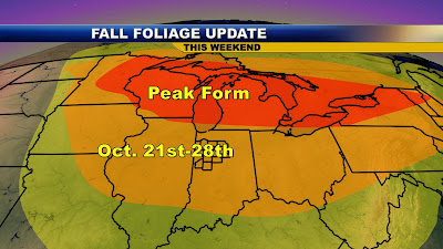
It is a big weekend and even though we do not have 80s in the forecast like last weekend it should be another spectacular one. We do have great weather for you if you are heading to Covered Bridge Festival or running in the Indianapolis marathon. I already have my running shoes laced up! The leaves are running about a week behind and I am expecting them to peak next weekend, but you will still have plenty of fine color to enjoy out there this weekend. Now there are also a ton of playoff soccer games and make sure the kids pace themselves because we are in a fast-moving pattern that could bring a brief warm-up on Sunday near 70 degrees!
You can see the quick northwest flow that will try to bring us sprinkles tonight and once again on Monday, but I would not be surprised if some of us do not see rain until the middle of next week. Temperature-wise do not get used to highs near 70 because our flow will remain from the west-northwest over the next week to two weeks with a huge drop-off in temperatures possible by next weekend. We have at least 3 chances of freezes and frosts over the next 10 days and I do not want to mention my favorite kind of weather just yet....shhhhhh but some maps are still showing our first chances of snowflakes before Halloween. I let out a shout at the station yesterday that scared a couple of our anchors. Now I do not want to scare anybody and it will likely not be enough to shovel but for now I will just keep quiet and I certainly will not mention it on the air until I have more of the models lining up. So considering these last tidbits of information I would give this weekend a 5 star rating just like you would get if you were at a world class hotel with fine dining! You can fire up the grill that is for sure.
Blog Question of the Day: What were those unusual rays of sunlight in the sky yesterday evening?
Here is the picture I captured yesterday of them on the Renaissance Camera. They are known as crepuscular rays or God's rays. I will let you know what causes them and why the farmers may have something to do with their formation this time of year so check back and while you are waiting here is some music from 3 Dog Night!
You see the scene last night at McCutcheon where a lot more was flying through the air than the soccer ball. At times it looked like a blizzard the rain was falling so hard in the lights. What a way to start off the area girls' sectionals. This storm was named Hunter in honor of the Full Hunters' Moon that was officially last night. Remember our first autumn storm was called Arabella meaning to bring rain and our second autumn storm needed a male name and Hunter certainly fit the bill. Since this is our weather blog we do not have to strictly stay in order when it comes to the alphabet so remember that when we name our next storm after a female.
I think Hunter is a perfect name because it will be easier to remember since it hit near the October full moon. Notice how beautiful the Hunter's moon looked on Tuesday night over WLFI, your one and only local TV station. You can see Hunter's clouds moving in and that full Hunters' moon looked a lot closer than 225,000 miles away from our parking lot that is for sure! Remember the corona we spotted around the moon on Monday night was our first sign of Hunter on the way. This was caused by the diffraction of light around the top and bottom of water droplets in the sky creating a wave pattern. Those odd blue and red colors are produced much the same way our CD's and DVD's produce when we tilt them a certain way in the light. Another good example would be a hologram. My only regret is not naming Hunter earlier as it turned into the real deal. Not to be outdone by the moon shot above, Hunter was putting on its own show at last night's soccer games and kicked up a quick 1.33 inches of rain on the southside of Lafayette. Here were a few more rainfall totals from our weather watchers around the area. I will add another chart when more totals come in by later today.
The big news was that we did have that isolated severe thunderstorm we started talking about here on the blog earlier in the week that we all knew nobody would call for but us! I have lived in Indiana almost 10 years and I am getting the hang of our weather mantra. As Hoosiers we all know that we get hit the hardest with the weather when nobody is expecting it. Well we met that criteria yesterday and I was not about to let our guard down. You see exactly where the wind damage report was located with the blue dot below which specifically was in Monterey located in extreme northeast Pulaski County.
Luckily everybody is safe and sound but there were a few trees that were uprooted along with downed powerlines. Wabash County reported trees on homes and cars with 60 mph wind gusts. The sky looked pitch black here in Tippecanoe County yesterday and luckily our line of storms did not bow out like they did farther north. Here is how it look on our up-close radar. Check out the bow shape I circled for you below.
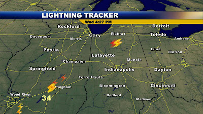
You can see what happens when a line takes the shape of a bow echo. This usually brings wind damage in Indiana and yesterday was no exception. The good news is we did not get a brief tornado which was not out of the realm of possibility. Why do we get these storms that pop up so quickly and with little warning. Well one problem is that even the most sophisticated computers cannot keep up with our ever-changing weather in the Midwest and also we are missing valuable in-put data into the supercomputer located in Washington, D.C. Tell me why we do not send up weather balloons in Indiana which has some of the wildest weather in the entire country. This has to change and I made my point for you clearly at the weather conference I attended this past weekend in Cleveland. Today was exhibit Z. I can give you 25 other examples of this happening since I have been at WLFI. Now the good news is we do have Live Doppler 18 which is real-time and can handle whatever nature dishes out. Speed wins and our doppler radar is faster than anything out there, including the National Weather Service radars. Now I am excited you will have lightning tracker to also keep you safe when we launch our new web-site in the near future. It gives me peace of mind since keeping you and your family safe is the biggest part of my job.
There is a nice sample of what you will be seeing in the near future above. Notice yesterday the only significant lightning strikes in Indiana were right where we experienced severe weather. Now today it will be a shock to the system if you do not have a warm jacket. Hunter is also helping to usher in our coolest weather of the season. Notice the free fall in temperatures last night.
No, this is not a Tom Petty song this is the real thing. We fell 25 degrees in 8 hours and the amazing stat of the night is that so far this autumn which is now over 3 weeks old we have only really felt like it for 5 of those days. Well in the seven day forecast all seven days feature fall weather including a frost on the way. I will have more on this and let you know tonight if our fall foliage will be peaking after all of this unusually warm weather. Now is a good time to remember the COATS FOR KIDS campaign we are running here at WLFI. I know a lot of our kids have outgrown their coats or they need new ones. Remember to bring by some of those old hats, gloves, scarves, and coats you do not need this winter so you can help keep a kid not only warm but safe from our wild Indiana weather. December looks like it will be a real bear. You can drop off those coats here at WLFI or at all area Hudlows locations. Thanks so much in advance. I have seen what a huge difference it makes.
While you are out and about running those errands today remember the Lafayette Christian School Bake Sale! This is one way to stay warm. There is nothing like heating up those pies when temperatures are expected to fall into the 30s like they are tonight! You can see a few of the dozens of volunteers peeling, coring, and slicing apples. They made up to 7,000 pies in just two days. The goal is to raise 40,000 dollars to lower the tuition for the kids. The cinnamon sugar mixture, pie crust, and crumb mixture of butter, flower, and sugar are well worth the 9 dollars and just think it is for a good cause. The pies are double wrapped and boxed for the freezer so they are as fresh as grandma's famous pies. Drive-thru pickup is on Brown Street, adjacent to Lafayette Christian School which is located on 525 N. 26th Street, Lafayette and its open from 8:30 a.m. to 6 p.m. both today and tomorrow while pies are still available. They go fast so hurry up, but please drive safely....LOL
Now to keep you warm tomorrow I will post my wife's special chicken wing dip recipe here on the blog. Here is our blog song of the day which is from the one and only Tom Petty in honor of our free-falling temperatures. Have a wonderful day and a special shout-out to my Wisconsin mother for helping our family out over the past week. Please come back soon! You were terrific!
 You can see Lauren and her Pre-School class had a great party. The scary part is they already loaded up on a ton of candy even before they all go trick or treating tonight. I may have to help Lauren eat all that candy. I am all sugared up so watch out! I look forward to heading out to the Mall for the shows tonight. I am still working on my costume. I can tell you there will be a lot of cars flying around and even a cow. That is the only hint I can give you.


 The only reason I am not going for record snow this winter is the main storm track has changed. The La Nina is now gone and we have about average temperatures in the Pacific Ocean. This means the main player this year will be the Atlantic Ocean and a blocking high pressure expected near Greenland. This bends the jet stream in a position that brings paralyzing nor'easters and even blizzards to the East Coast. Take a look at this year's winning storm track.


 There is our newly designed weather set and that is not the only reason Stefanie is smiling. She brought in her lap top computer and we both went over BUFIT data in detail. BUFKIT is a forecast profile visualization and analysis tool kit developed by the staff at the National Weather Service (NWS) office in Buffalo and the Warning Decision Training Branch (WDTB) in Norman, OK. As of January 2001 it is in use in over 75 NWS, Department of Defense, University, and Environment Canada locations. Basically BUFKIT helps you fine-tune details of a forecast and it is a great guide for snow forecasting. Well, let's see what we found!


 Notice our area of low pressure is caught between two jet streams with nothing to really push it along. This is why these cut-off lows are very slow-moving and the latest models not only hold off the thicker clouds for us but the timing of rain until at least late Thursday and more likely Thursday night and Friday. So bring in Professor Boots and all the cats and of course B.J. and all the dogs along with your sensitive plants tonight. I will detail those lows tonight on the newscast. This is a sign of things to come as you see below.
 We are in a highly amplified pattern and this meriodonal flow will only become more extreme next week as a ridge of high pressure builds out west. This will allow a real good chunk of arctic air to pour south. Our highs will be stuck in the 40s it looks like by Tuesday and Wednesday with a few lake-effect snow showers possible as far south as Indianapolis! Some maps have chances of snow all the way to North Carolina.