Saturday, February 28, 2009

Historic Snowstorm for Deep South & Winter in Charge Here at Home

The big swirl you see over Nebraska is our upper-level disturbance that will turn into a cut-off low pressure in the Deep South. Snowflakes could fly as far south as Florida and heavy snow will be possible as far south as Atlanta. It could then turn up the Coast and finally give Washington, D.C. its first real snowstorm now that meteorological Spring is here. The amazing part of all this is that we will have better travel weather in Indiana than down in Tennessee, the Carolinas, and even parts of Alabama, and Georgia. We should not be complaining about our single digit wind chills over the weekend and those few stray snow flurries.


Even better news is the drier weather will help river levels to start dropping by later on Sunday. Forecast crests will be in the minor range. You see the Wabash River crest at Lafayette cresting at 1.7 feet above flood stage on Sunday. The Covington river level will be cresting at 1.2 feet above normal. This is great news considering most areas have had about 200% their normal precipitation this month not including all the snow melt.


Things should be nice and quiet for much of the coming week and this is the perfect time for me to take my best friend and wife on what you can call a Ground Hog Day present trip that was planned. I think she liked her Valentine's Day gift this year. Remember we celebrate it on Ground Hog Day! I wanted to make sure you knew that I am taking a few days off and will be back on Thursday. We are starting up a new and improved weather blog on wlfi.com and will have more details coming. Right now it is under construction and I will be taking time to help finalize this transition so you have the best weather blog possible.

My wife and I are looking forward to a few days away and cannot believe we will be all alone. I want to thank my mother-in-law for coming in from Wisconsin and helping out. This will be kind of like a second honeymoon for Julie and I. When is the last time we had a trip for 5 consecutive days alone? It may have been our honeymoon cruise almost 14 years ago. It is fitting we are going back to our private place we got married at. It is our get-away place that I feel every couple should have. We may have waited too long, but we found a way back and most importantly back together.

Do not worry! Please do not look into this more than you should. I do look forward to coming back to Indiana to take you through the rest of March Mayhem. It should be a fun month that is for sure! We need to get our picnic planned as well and I think a mid to late April picnic should work. If we wait until May I may be called into work to track tornadoes with you and it may spoil all of our good food and fun we will be having. So we do not want to wait too long to set up our weather watcher and blogger picnic. I will also work on T-Shirts with brow and promotions when I get back! It will be fun! Now it is Julie time!! Keep on blogging and have a great weekend. I do have a lap-top I can check in with you on. I always like hearing what you are doing and of course all your great weather stories and observations!

Friday, February 27, 2009

March Will Be In Like a Lion and Out Like a Lamb


The origin of this weather proverb, " in like a lion out like a lamb" was first written about in England in 1624. Almost 400 years later it is still one of the most famous weather proverbs not only in England but the United States. The month of M
arch is a notorious transition month with plenty of ups and downs and since this weekend our weather team is forecasting a chance of snow with temperatures a good 10 to 15 degrees below average along with wind chills dipping into the single digits. In other words March is coming in like a lion.

Winter's roar is certainly being heard loud and clear. By later in the month as our days grow longer and Spring air masses become more prevalent our chances of nice tranquil weather or March going out like a lamb increase. So for now I am going to say we are going in like a lion and out like a lamb. But of course here in Indiana there are no guarantees and we all know that the lion can roar all the way up until Mother's Day sometimes. Will this year be different? I do think we will see some more accumulating snow in March with plenty of ups and downs. The good news is that our average highs reach near 60 degrees by the end of the month so the weather does become much easier to take. In fact I was amazed that this weather proverb has worked very well 8 of the past 10 years. So we will keep that glass half full and say it will work out in our favor this year, even if that glass is half frozen this weekend. :)


This is the picture of the snake Suzi and I saw along the Wea creek.

It is very unusual to see a snake in February, since they like warmer temperatures. Thought Mike would find this interesting. Maybe we are going to have a early spring.

Lynn

Thanks Lynn. I know these snakes usually do not come out until late March when we start averaging about one thunderstorm per week. The old Hoosier saying is that the thunder shakes them out of hibernation. Well I think our back to back days with highs near 60 did the trick this week. But in only 12 hours we went from a few rumbles of thunder to a light covering of snow for our weather watcher Mary Beth in Kentland. I think this snake is sorry he or she came out early this year. The lion is coming! Winter is roaring back into our forecast. Also, I do not think we will have any moth reports for awhile with winter taking hold once again. But that is okay I found a great way to stay warm and did enjoy some great company on my Friday!


I want to send a special shout out to the Creative Corral Pre-Schoolers at McCutcheon. Those kids and teachers are incredible and I enjoyed every bit of my visit and field trip with them. I had a blast going to the bowling alley with the kids and even had a nice lunch and then plenty of play time. My fun did not end there. I went by and saw the Future Farmers of America exhibits at McCutcheon High. I learned a whole lot and did not realize how important donkeys can be on the farm and yes that pot-bellied pig was huge! You see Lauren enjoying the miniature pony below. The McCutcheon students were great tour guides and they are even awesome chefs for their teachers from what I hear!

As you can tell I had a great time with my daughter Lauren, her class, and all the great folks at McCutcheon. By time our day was done and I had to get ready for work Lauren told me that it was the best day ever. This makes a Dad feel absolutely terrific and I look forward to spending more days like this with Lauren and my whole family. The best part of my job is not in front of the camera it is actually getting out in the community and seeing all the wonderful people that make it a truly special place to live. Have a great weekend.


Thursday, February 26, 2009

Cold Front Charging Our Way!


Rainfall Updates as of 2:00 a.m. The news is terrific. Yes, we had a couple of loud booms of thunder, but no severe weather reports across the area. Most of our wind gusts remained close to 40 mph and the heavy downpours moved fairly rapidly through the area. We can consider ourselves likely and I think any flooding on the rivers should be minor.

Update as of 10:20 p.m.

Our first few rumbles of thunder have been reported in Benton County. A report of pea-size hail near Perrysville in Vermillion County....Latest Live Doppler 18 scan still showing everything is on track with our main threats being heavy downpours and wind gusts near 40 mph.


Update as of 10:00 p.m.


Thunderstorm line continues to lose intensity with no lightning being reported in Indiana as it moves across the state line. Wanda in Boswell does have some heavy downpours and gusty winds near 30 mph. I would not be surprised to see a few gusts in the 40 to 45 mph range between now and about 2 a.m. as this front passes through the area. There is still a small chance of a little pea-size hail but as of now expect a quick half-inch of rain along with gusty winds. Be careful on the roadways over the next few hours and then we will get ready for the big temperature drop!


Update as of 9:30 p.m.


The cold front moving our way does not have much lightning associated with it at this time. The number of lightning strikes across northern and central Illinois have decreased rapidly as they have approached Indiana. The severe thunderstorm risk area will likely be from St. Louis into southern Illinois and Indiana. Here at home we could still see isolated wind gusts of 40 to 50 mph, a few rumbles of thunder, and brief heavy downpours. I will check more data and be back!


Dense Fog Lifts, Now We Brace for Wind & Rain


I hope everybody is doing well and feeling well. The late winter flu that has been going around has hit my family. My daughter is home from school for the third straight day. She seems a little better today but this thing going around seems to linger on forever and I have been fighting it for most of this week. No way will it keep me down. There is just too much interesting weather to track. Now the big question is will we need urgent care when it comes to our weather today and tonight. First of we can blame all the illnesses going around on the incredible ups and downs in our weather and there really is no end in sight. Take a look at
forecast high temperatures by Friday.

This morning we did need to slow it down on area roadways with visibilities down to near a quarter-mile in many locations with patchy dense fog. This was due to a warm, moist south wind that caused our dewpoints to rise while at the same time our temperatures were slowly falling. The closer your temperature and dewpoint the better chance of fog developing, especially with light winds and that is exactly what happened. The worst of the fog will be out of here by mid-morning as we start heating up and the wind picks up ahead of rain.

Speaking of rain....how much is on the way and will there be flooding?


Let us start with the area rainfall. So far this month we have had 2.52" of precipitation in Lafayette. February is normally our driest month of the year and we average only 1.57" of precipitation. Well this year we will likely double our February
monthly averages and on top of that we have melted down about .75" of liquid that was stored in the snow pack we had. This means we do need any more rain or snow. The ground is saturated and our rivers and creeks are still not far from bankfull. Well, I have good news! The latest model data has most of our viewing area receiving less than an inch of rainfall. The main track low pressure track will be heading to Chicago and it is far northern Illinois and Indiana that will have the heaviest rain. So even our friends in Remington, Rennselaer, and Winamac should be okay. We could see a slight rise once again in our river levels but I am not expecting flooding at this time. Bottom line is that most of us end up with less than an inch of rain.


Severe weather potential: I went through a big list of things this morning that includes wind shear, helicity, upper-level winds, and instability indices. The good news is I think we will not only dodge the worst of the rain but also the severe weather. Things are just not lining up right at this time. The atmosphere will be most unstable at 9 p.m. but the main cold front that will add lift to the atmosphere does not arrive until after midnight. The jet stream that usually adds spin to our thunderstorms that can lead to damaging wind, tornadoes, and even large hail is well south and west of Indiana. Areas near Oklahoma and Arkansas look to be the bullseye for the big thunderstorms. You see the severe weather risk above and I agree that it should stay west of our viewing area.

The one thing that I did find interesting is that once the front comes through after midnight we could briefly see wind gusts in the 40 to 50 mph outside of thunderstorms. When you are going from temperatures from near 60 today to only near 30 by late tomorrow this huge temperature gradient creates big pressure differences and a higher likelihood of high wind gusts. I do think the high wind gusts will not last more than a couple of hours so a high wind advisory will not be likely. It will remain breezy though with wind chills falling into the teens by late on Friday.

Tonight make sure to tune in and we will track the rain and wind together and find out about a very cold weekend ahead. It may be so cold that chances of snow will be possible as far south as Alabama, Georgia, and even the beaches of South Carolina. We will take a closer look at major changes that have taken place in the atmosphere over the last 10 days and why it may be a sign of a much colder March. Remember to send in some rain totals and I do think we could still hear a few rumbles of thunder tonight but the line of storms will dramatically weaken as it moves our way after midnight. This afternoon we will have a weak line of scattered showers which means we can still head to the park before winter makes a comeback. It is time for lunch! I am ready for some egg salad and soup! Be safe and stay healthy!

Wednesday, February 25, 2009

Comet Watching & Looking and Smelling Like Spring

What a spectacular Mardi Gras sunset showing high-level moisture traced all the way back to the tropical Pacific Ocean. Our Fine Fat Tuesday will give way to a Wonderful Wednesday today!

It was a Mardi Gras to remember at WLFI....it got a little wild....most of the night crew got up on the roof. It was my idea of course since comet Lulin was in the Lafayette sky last night in the southeast. I told everybody to look east-southeast or almost the exact opposite direction from where Venus was setting in the West. Unfortunately nature put a bit of a damper on our "sky party" with cirrus clouds that blocked out what could have been a breath-taking view of a two-tailed comet. Usually comets only have one tail but the solar wind has distorted Comet Lulin's tail with speeds approaching one million miles per hour! The amazing part is this comet is passing only about 14 million miles from the moon which means it is not all that far from the earth astronomically speaking. It is a rock throw away. The night crew was a bit disappointed and thought I was just teasing everybody. Now, I have never been known to do that....well not too much at least. :) The comet did not appear yesterday evening but I told them we will have ample opportunity to see this amazing comet as we head into March. I will keep you updated on it here on the blog. It should be visible without binoculars which is impressive. Comet Update as of 12:30 a.m. Reports of Comet Lulin in the area....now that is more like it. Send in those pictures please!


Now a lot of folks are excited about our Spring pattern and I was educated as to one of Indiana's first signs of Spring today thanks to Richard Beedle. The picture above tells the Spring story nicely. That is right the skunk cabbage is out and its flowers are among the first signs of Spring. Here is a nice picture sent in from Attica yesterday. Richard tells me that this cabbage does actually smell like a skunk if you break its leaves in two. One other interesting tidibit...the smell of skunks in the air this time of year is a sure sign of Spring. It does not come from the cabbage above but from actual skunk mating season that takes place this time of year. The male skunks apparently spray each other when fighting for the females! The mor
e traditional signs of Spring were also in the air yesterday with singing robins in Monticello, flocking geese to the north in Stockwell, sandhill cranes over Lafayette, and believe it or not daffodils and tulips two inches out of the ground on the southside in Lafayette. Spring is everywhere you look including the latest weather maps in tonight with back to back days in the 50s expected. Is it here to stay? No, it looks like we are still in that same wild pattern we have had most of the winter with plenty of extreme weather.


This winter has been a very average winter when you look at days above average, days below average, and near average. Snowfall is at 18.2" which is exactly normal for this time of year to date! I will have the entire breakdown on tonight's news. It has been called a rough winter when in fact it is really a typical Indiana winter. We just have been spoiled rotten over the last couple decades. Now that the Pacific Ocean is flip-flopping to a colder cycle and the sun is going into a solar minimum and settling down, the winter we had this year will be more common with even snowier and colder winters becoming more likely. The only thing certain about our weather in Indiana is that it does not stay quiet for long and our tranquil sunsets can turn into raging rivers and creeks in an instant like you see above! Tami Conn shows us a picture of the Wea Creek earlier in February when flooding hit the area. When will this happen again? Sooner than you think. Tune in tonight and I will have more on the blog shortly! Here is your weather quote of the day:

"Its not about how hard you can hit, its about how hard you can get hit and keep moving forward".

-Rocky Balboa


This sounds more like a weather quote to me and sums up our weather very nicely this winter. We have been hit over and over but nature has not been able to knock us out. We have just too much heart. The weather bloggers on here and our wonderful viewers cannot be denied about the fact that Hoosiers are seasoned and tough. Nature will throw a few more left hooks and combinations at us before we get the warm weather to stick around. But by working together we will come out victorious Rocky! Rocky! Rocky! We can nickname Thursday's storm Mr. T. I will have more on "T" tonight and what we will need to do to prepare for it!


Tuesday, February 24, 2009

Flat Stanley Visits Lafayette & Brings Warmer Weather from Houston!


Flat Stanley takes on Lafayette. Flat Stanley was sent by Cameron Barton from Houston, Texas. For those of you familiar, Flat Stanley is based on a book where Stanley was rolled by a steamroller and his family mailed him to California. It is a great
experience for kids to learn about other parts of the country by creating their own Flat Stanley and sending him on tour.

I want to give a special shout-out to all the school kids in Houston, Texas this morning viewing this blog. What you see in the picture above is my daughter Lauren getting some help from Flat Stanley. Lauren and Stanley were my big helpers on Saturday as a half-inch of one inch of snow fell on Lafayette, Indiana. If you look closely you can see Flat Stanley holding the snow shovel in Lauren's right hand. Lafayette is located an hour north of Indianapolis or Indiana's state capital and two hours south of Chicago. Lafayette was named for one of George Washington's best friends and an American Revolutionary hero who served in Washington's Continental Army. Marquis de Lafayette helped turn the tide of the war by holding off Cornwallis' troops at Yorktown as well as winning the Battle of Rhode Island. He gained our country's first honorary U.S. citizenship.


Lafayette is known to have some of the wildest weather in the entire country where you can have all four seaso
ns in the same day. We have just as many tornadoes per square foot as Oklahoma does on average. One day I came to work on May 30, 2004 and tracked 11 tornadoes in only 3 hours. You see one of two tornadoes above that hit Dayton, Indiana which is located in the Lafayette area's tornado alley. Amazingly, the only person that was injured was struck by lightning. Even though we do not have hurricanes in Indiana, we have hurricane force wind gusts in many thunderstorms that roll through the area. Severe thunderstorms have occurred in every single month of the year. We average a blizzard about every eight years, including our last one on February 13, 2007 that buried Lafayette with 17.5 inches of snow. This is what makes it so fun to be a meteorologist here in Lafayette, Indiana. It is a great place to call home!

The most important part of my job as a meteorologist is to keep people safe and it is a huge responsibility. This is not a glamorous job by any means. You have to really love what you do and realize it is a 24 hour a day/7 days a week job. Do not expect to be off on holidays. The show must go on and you are really needed the most when people are going to visit loved ones. You have to be 100% dedicated or this job is not for you. I do highly recommend becoming a television meteorologist. It is a job like no other and one I feel very lucky to have. The television part is really not the biggest part about what you really do. You serve your community not just on television but by actually getting out and taking an active role in your community. This should be a prerequisite no matter what you end up doing in life. The school talks and volunteerism are definitely among the most rewarding parts of this job. It fires me up, literally! I have run in 6 marathons and counting. My motto is pray hard, run hard, and work even harder. I have done weather on television now for 14 years which includes stops in Jacksonville, Florida (Hurricane Andrew in 1992, Storm of the Century in 1993) and Gainesville, Florida (flying frogs and tropical storms).... Duluth, Minnesota (my weather watcher set state record low of -60 and we had 230 inches of snow in 17 months)...Myrtle Beach, South Carolina (Hurricane Bonnie, Dolly Parton shows, the Pavilion Amusement Park, and snow on the beach!).... and Lafayette, Indiana (tracked over 70 tornadoes and the blizzard of 2007). I have a little Flat Stanley in me with all the places I have been! :)

While in Lafayette, Cameron's Flat Stanley went to the courthouse, saw downtown Lafayette (you see him with my oldest daughter Megan above) and then headed over to Purdue University which is home to the Boilermakers and many famous astronauts.


Flat Stanley took in Triple XXX or one of our country's oldest diners, the Union and the Neil Armstrong School of Engineering. The girls then took Flat Stanley to the Tippecanoe Battlefield in Battle Ground, Indiana. This was the precursor to the War of 1811 with Great Britain. This area if full of significant historical landmarks and has had plenty of famous people visit here such as Ulysses S. Grant and Mark Twain. Eli Lilly served his apprenticeship here and Dr. Mayo had a medical practice downtown. The best part of all was Flat Stanley will be added to the list of famous people to have visited Lafayette, Indiana. It has been a long time since there has been this much buzz in Lafayette and I made sure to give him some credit for bringing some of the warm weather from Texas with him. Flat Stanley is on his way home to Houston with some pictures and a couple souvenirs of the Lafayette area for Cameron. May you have a great summer full of much needed rain and may all the hurricanes and tropical storms miss you!


Here in Lafayette everybody seems to have Spring on their minds since Stanley arrived. So by popular demand I keep those Spring facts coming your way. Check them out. Even the robins around the area are getting antsy and looking inside homes for warmer weather. This weekend both Saturday and Sunday were very cold with highs only in the 20s and wind chills mainly in the single digits and teens. But check these Spring facts out!

1) Meteorological Spring begins on March 1st and is only five days away.

2) Forecast highs will hit 90 in parts of West Texas this week and 70 in Lafayette in 2 weeks!

3) Daylight Saving Time begins on March 8th and Lafayette's sunset will be at 7:47 p.m.

4) The sun angle in the sky is getting so strong this time of year (almost as strong as a September sun) that our snow melted this weekend despite highs only in the 20s.

5) The coldest part of our winter is over!


Your inspirational weather quote of the day for Texas and Indiana:


"Life should not be measured in years or the number of breaths we take,
but by the moments nature takes our breath away."


This happens quite often in both of our great states and no matter where you live it is what connects all of us. Tune in tonight whether you live in Lafayette for some more breath-taking weather on the way. How bad will those thunderstorms be on Thursday and will March come in like a lamb or lion? If you are in Texas head to http://www.wlfi.com to find out if it will in fact hit 90 degrees in parts of your state and if you will be getting some needed rain. See you soon. It is about time this blog goes national. Have a great day! Thanks again for joining us Houston, Texas.

Monday, February 23, 2009

Looking & Feeling More Like Spring as We Finish February!


Wow! I think it may have been the warmest 31 degrees I have ever felt. That was Lafayette's official high today. Keep in mind that is a shade temperature taken about 5 feet above ground level. In the sun this time of year you can add abo
ut 15 degrees to the temperature. So our 31 was more like 46 especially with the light wind. Yes, 31 degrees this time of year feels much better than it did in January due to the stronger sun angle. Our sun is almost as strong as it was way back in September. Remember the month that produced highs in the 80s and 90s! Tonight we will talk about actual temperatures reaching into the 50s with some spring thunderstorms possible. It is fitting since Sunday marks the first day of meteorological spring. It will be a frenzied finish to February but it looks like it will be the warmer days dominating more than the cold days for once. I look forward to seeing you tonight on the news with our glass more than half full as always! I will also have more signs of Spring for you coming up!

The plunging temperatures will finally give us a break and speaking of plunging I want to congratulate WLFI's very own Julie Krizen and Sue Scott. They both helped raise over 1,500 dollars for the Public School Foundation by partaking in the Polar Bear Plunge this weekend out at Tapawingo Park. They braved bitter wind chills in the teens along with snow flurries. Julie Krizen, above won the best costume. She dressed up as the Florida Sunshine since she was born and raised in Sarasota, Florida. The Sarasota Sunshine girl told me she has never been so cold and she was still shaking two hours after the big plunge, even after a 30 minute hot shower. This is the same girl that wore winter boots for the first time in her life this year. Julie Krizen has come a long way and is well on her way to becoming a true Hoosier. This was a big test she passed and most of all it was for a good cause.

Overall this event raised over 5,000 dollars that helps award grants for teachers in the classroom. They can do fun things such as teach ki
ds in ways that really motivate them. I heard one story of a teacher using a grant to set up a CSI crime scene for her kids! This is great stuff! It is a great feeling when you can give back something to your community that makes a difference. Julie and Sue were "shining" examples of this on Saturday.


Our future is certainly bright like the sunset over Wolf Park on Sunday. Monty Sloan took this picture from the Wolf Den. This red sky at night certainly did turn into a Hoosier delight on our Monday. It was a great start to our week and it will only get better from here as polar high pressure moves out, a warm Pacific flow moves in. In other words, a taste of Spring Fever is on the way!

Sunday, February 22, 2009

More Flurries Fly As We Stay in the Deep Freeze


It should be an interesting last week of February on the way. It never is dull this time of year. Today is a big day for our country. It is George Washington's birthday. This is significant for all weather lovers, bloggers, watchers, and enthusiasts. George Washington was not only one of our founding fathers but he was one of the first Americans to keep track of the weather. His dove of peace weather vane still sits on top of his Mount Vernon home. He also had a couple of prized thermometers that he kept track of the weather with that are still in pretty good shape. His recording of -17 degrees in Philiadelphia in 1788 went down as one of the coldest days of the 18th Century. Here is an excerpt from George writing about the weather in his diary.


The 22nd of February, 1793: "And as it is not only satisfactory, but may be of real utility to know the state of the weather as to heat & cold, but drought or moisture, prefix, as usual, at the head of every weeks report a meteorological account of these. The Thermomiter which is at Mount Vernon will enable you to do the first". This was just one of several weather references in his diary.

Today it is important to know the state of the weather especially with wind chills remaining in the teens and by late tonight falling to near zero. We still have a few weather disturbances pivoting around in our cyclonic flow. This will keep our chances of snow flurries going through at least late tonight but there will be little or no accumulation.

We will come ouf of the deep freeze by Tuesday afternoon with rain and maybe even a thunderstorm by Thursday with highs near 50 before we track another winter weather event next weekend which could bring more slushy snow. I know a lot of folks are looking for Spring weather. I will make sure to talk about this transition here on the blog tomorrow and why it could be a rough one. We will also have to watch area rivers by late in the week once again with some models showing close to an inch of rain possible on Thursday. The Wabash is still running near flood stage. Have a great day and stay warm.

Saturday, February 21, 2009

No Surprises But Brace for the Wind Chills & Slick Roads

You can see the wet snow sticking to some of the trees around the area. Be careful on the roads as this slush turns to ice this afternoon! Thank you Justin New for sending this picture in! There are no days off for meteorologists or bloggers. :)

Here is the latest as of 8:50 a.m.


Today: We will see another band of rain and snow changing to all snow by 10 a.m. with a quick half-inch to one inch of snow expected by late day with falling temperatures into the upper 20s by early evening. Wind chills will plummet into the teens with a west southwest to west wind at 15 to 33 mph.

Slick roads will be developing this afternoon and tonight with the much colder temperatures and while we will not have a big snow we will still have to be weary of icy roads as temperatures do a free-fall. Even though we will have a wet snow today, some blowing and drifting snow is still likely as our light snow covering dries out quickly in the arctic air. Winter weather advisories continue across the northern tier of our area where I expect accumulations in the one to two inch range and a little more in the way of reduced visibilities and blowing and drifting snow.

Now it is off to the Prangley family weekend......it will be crazy with tons of things going on but that is the way I like it! If anything changes I will check back and of course I will be back to blog with you later on.

Friday, February 20, 2009

Sectional Pairings Snow Fizzles Out!


It is true the models that were having trouble getting a handle on this system all week long are now playing catch-up and I think we will end up with an inch or less in Lafayette. It is good news for all the travelers. The old Hoosier saying that we get a big snow around sectional basketball time looks like it may not come true this year. Over the course of the week I am glad we were all in agreement with those lower snow totals, but I am a bit surprised at just how much this system seems to have fizzled.

One big reason for this is the latest storm track shifting about 50 miles farther north. With this storm going so far to the north it will draw in even warmer temperatures helping to keep snow totals down. We could wake up with above freezing temperatures tomorrow morning in Lafayette! This is why I am downplaying snow accumulations. Also, I would not be shocked if a little rain mixed in as well. We of course will not let our guard down and watch this system carefully as it moves our way at over 120 mph!!
Strange things have been k
nown to happen. There are winter weather advisories from White County northward. These areas could squeeze out a couple inches of snow. Kids will at least have a chance to make miniature snowmen or should I say a "slushman". If you are traveling north to South Bend or Chicago, those are the areas that have real snowman and sledding weather. Here at home we will have light and intermittent snow. Here is your latest snow time line.


I will check back later this evening with an update...hopefully by 10:30 p.m. Have a good night and enjoy those basketball games!

Red Sky at Night a Snow Lover's Delight


It was a cold Thursday but it was a fine finish with an absolutely gorgeous sunset. You are looking at a nice shot of a sun pillar that is more common in Alaska than Indiana. Ice crystals usually found at 30,000 feet were huddled close to the ground in our arctic air mass and it resulted in this beautiful phenomenon. The beam of light is being caused by sunlight being reflected off the undersides of fluttering ice crystals. Now the old saying is that a red sky at night is a sailor's delight, but in this case it is a snow lover's delight. If you read one of my favorite books called the Weather Companion by Gary Lockhart you would find some interesting research on if this weather proverb is actually reliable. It actually is a good indicator of the weather to come and is correct 71% of the time in the summer. But it is not foolproof by any means and is only on target 57% of the time in the summer due to those late day and sometimes overnight thunderstorms that fire up. So our next snow maker on the way has already defied the odds. We will have some unsettled weather moving in by late tonight. The question is will this storm pull another trick out of the bag and surprise us with a much bigger snowfall. One model already says it will! Take a look.

Now all of our anchors were rooting for models 1 and models 3 and of course I was ready for model #2. Our snowfall so far this winter is at 17.5 inches of snow which is slightly below our average to date of 18 inches. My pre-winter forecast of between 25 and 30 inches needs a little help so I say bring it on! What meteorologists do is look for consistency in the models and numbers one and three have been very steady over the last couple runs while model two continually changes with the wind. So I will have to go in the two to four inch category with still an outside shot of higher amounts. These clipper systems have been known to surprise this time of year and it is moving our way at 120 mph. Sometimes our models cannot handle this type of set-up so we will take it hour by hour as the snow closes in on us this evening and overnight. Here is my latest snowfall forecast which could still change, but my forecast confidence is much higher tonight than last night. Prime time for snow will be from about 4 a.m. through 11 a.m. on Saturday. The farther north you go the more the snow you can expect so be careful!

Of course our weather team will keep you updated throughout the day and I will do special blog updates as needed. Look for a winter weather advisory to be issued today. Make it a great one and Happy Friday!

Bloggers thanks for staying up late with me again tonight. It was almost like we were playing the Price is Right.....and I think most of us agreed that number 2 was still just a little too high! I think tonight's snack choice in honor of our snow will be some mint chocolate chip ice cream. I will run it off later! :)


Thursday, February 19, 2009

Models Still Having Trouble, But Snow is Still on the Way

11 p.m. teaser!

Here are the latest runs just in of the best model data I have:

Friday night and Saturday snowfall forecasts:

1) 4.4"

2) 7.2"

3) 3.2"

4) 2.4"

5) 4.0"

6) still initializing


So will I go with model number 2 for all the snow hounds...tune in to find out! :)

That sunset was gorgeous Richard! I will have a picture of it on here and the air coming up soon!


Beware of the 3 S's: The Siberian Express, Snow, and the Saskatchewan Screamer

What a pattern! We are back in mid-winter form. Bring in the pets, although in my case I will have to go find mine because he is hiding under one of our beds. I asked him if he wanted to go on a walk and he ran upstairs. Yes, our Prangley dog BJ is a basket case. This weather has a lot of folks all shook up. There is a lot of shaking going on with wind chills plummeting to near zero early this morning. Yesterday, we had tons of reports of Canada geese flocking northward and you can see they actually invaded Mary Anne in Remington's bird feeders above. Well, apparently once those cold winds hit the area last night they were spotted heading south again. Now I think they are onto something. I am worried about the sandhill cranes and their paper thin legs which will not take long to freeze in this weather. Hopefully they are finding some warm nesting sites. This cold outbreak is being caused by the Siberian Express.


I call it this because this cold air has been tracked all the way from Siberia where there is still plenty of cold air. Check out our weather update from Siberia which includes pictures of frostbite and an update from our Siberian pen pal via his Mom!

Hi, Mike,

Attached is the photo of my son, Cole, at -49 C in Surgut, Russia (in Siberia). The white spot is frostbite. This mama is trying not to worry... :D

The other photo was take in December. Cole says he climbed 840 steps to get the view of Mt. Medeyu (not sure where that is, but it's somewhere in Russia.)

Enjoy!

Lynn Isenbarger
West Lafayette


Thanks for sharing this Cole and Lynn. We have nothing to complain about here in Lafayette after seeing that picture. Tell Cole to cover that face up and hopefully he was not in too much pain once he went inside to a warmer location. I know that frostbite can be quite painful. I had a milder form of it when I lived in Minnesota and to this day I still have trouble with that small patch of skin on my hand, especially when it is cold and dry outside. This is a good reminder that frostbite will be possible in as little as 40 minutes this morning. Bundle up the little ones. A piece of this bitter cold air Cole saw last week in Siberia is settling over our area. Luckily it had some time to at least moderate a little. Here is the latest check o
n what Cole is experiencing in Siberia today. Unbelieveable....still near -55 degrees without wind chill! Ouch, it hurts just typing that. Siberia is located in the upper corner of the map....the left side of the map is Greenland, northern Canada, Alaska.
At least it looks absolutely beautiful there. Here is the picture of Mt. Medeyu.


Now I know some of you need to get some sleep and so do I. Try to lay off the ice cream. I heard that is really bad for you this time of night. I usually eat more before a nice big snow so it will be tempting, but I am making a pact with you tonight....a sandwich but no ice cream. Besides, I will be in boot camp with Kristen at International this weekend and I want to survive. If you have not taken agility jam I highly recommend it.
Okay, here is the deal.....the models right now are a joke but I am looking a climatology for this time of year and I love our chances of this clipper system going above and beyond for snow lovers here in Lafayette. Usually clippers bring our area one to three inch snows in the winter. But this is not a usual circumstance. Meteorological Spring is less than 10 days away and thermal contrasts or temperature differences tend to energize these type of weather makers this time of year. So our one to three inch snowfalls are sometimes doubled. Take a look at today's highs.


On Friday a similar temperature gradient will set up over the high plains helping our Sasketchewan Screamer hold together. It will actually be even more impressive with a range from single digits to 50s in a span of just 250 miles! We are also calling our clipper the Saskatchewan Screamer because this is where I think this system gets its act together and develops. The province of Saskatchewan in Canada is located east of Alberta. It is also called a screamer because it moves very quickly and this one will be no exception. It will be riding in on a 125 mph jet stream out of the northwest.


My first call holds....I like 3 to 5 inches of snow moving in late Friday night and Saturday morning. The European and Canadian models (NOT GEESE) are my models of choice. The GFS seems to be coming around nicely as well with 5.2 inches of snow being cranked out for Lafayette with the main track going right over Randy's house in Frankfort. This is an increase from late last night when it printed out 4.4 inches of snow for us. It should be fun to see what happens. But I really like our chances for good sledding weather this weekend. The SOUTHSIDE SNOW MOBILE CLUB WILL BE HAPPY! They will get the three or more inches of snow needed! Send in some pictures. I am really rooting for this one because my original winter forecast was for Lafayette to have 25 to 30 inches of snow. This would put us closer to that range. I will have more on just how much snow we actually have had and where it compares to normal here on the blog and on tonight's newscasts. Speaking of snow, the second "s" which stands for snow and slippery roads are already out there after our rain changed to a dusting to almost an inch of snow in spots last night, there are some icy patches on the roadways out there. Make sure to be safe and allow extra time. Some car doors may be frozen shut after the big temperature fall. But as Hoosiers we can deal with this and handle it. Here is an inspirational quote before I go have some green tea (no ice cream).

Summer is delicious, rain is refreshing, wind braces up, snow is exhilarating; there is no such thing as bad weather, only different kinds of good weather. -John Ruskin

Wednesday, February 18, 2009

Temperatures Plummet & Slick Roads Return


I still like a half-inch to one inch of snow across the area. The snow should be heaviest between 8 p.m. and midnight before it settles down. Temperatures will only be in the middle to upper teens by morning but more importantly wind chills will be near zero as you can see above. Usually computer forecasts cannot handle the dense, heavy polar air masses as they move down from Canada. I like to subtract at least five degrees from the numbers you see above to get a real idea of how cold it will feel. BRRRRRRRR!

The bigger snow system I am watching arrives Friday night into Saturday morning. I will have more on that tonight at 11 p.m. and it even has an unusual name you may not have heard of. Right now we should have no problem seeing two to three inches of snow. The real question is can we squeeze out five inches of snow in some areas. See you soon and send in some snow pictures if you can a
long with those totals. Thanks for all your help!

Visibilities across Illinois and northwest Indiana have dropped to near one mile so this snow will cause some problems on the roadways in a hurry. Be careful.

Here are those all-important rainfall totals from our weather watchers. What a difference a week makes! The rivers will not be raging this time around but continue a nice slow fall! You can see nobody out on the John T. Myers pedestrian bridge and for good reason as those bitter winter winds have returned. Just think those 70s will be here in two weeks!


Our Freaky February Continues, Get Out the Layers, Hot Chocolate, & Snow Shovels!

It is great to check in with you. I am just finishing cleaning up lunch with Lauren. We had chicken noodle soup and chicken nuggets. I made sure to have some cheerios with frozen blueberries so I can run my 5 miles today with some extra kick. The dog has been acting strange. He may sense the big weather change on the way. He has been running around the house wild and nature is about to go wild with our nice Spring-like temperatures early this afternoon about to come crashing down. Our computers went down last night at WLFI so my middle of the night sandwhich weather update was delayed but it has allowed me to look at more data and give you the first real sneak peak as to how much snow is on the way for this weekend and next weeks big Spring push of warm air.

February is known for its big temperature swings and it will live up to its name. We will go from temperatures in the middle to upper 40s early this afternoon and drop about 2 degrees per hour or 20 degrees by 11 p.m. If you add in the wind chill it will feel even colder and feel like the single digits by time you get ready for our 11 p.m. newscast. Make sure to stay warm with your one and only local station tonight and have a nice warm cup of hot chocolate with us. I have hoisted hot chocolate advisories for our area. By morning lows will be in the upper teens with wind chills from 5 below zero to near zero across the area. Actual lows will be in the middle to upper teens. Make s
ure to have the layers ready.

The good news with this system is that we will not have the hurricane force wind gusts with it as the cold front pushes through the area but unlike last week we will have to be ready for some slippery roads developing. I expect rain showers to change over to a few heavier bursts of snow between 8 p.m. and midnight and we could easily see a half-inch of snow to an inch of snow before it tapers off to flurries after midnight. Wind gusts will be near 35 mph causing reduced visibilites around the area.

Wabash River Update: Cold weather tends to slow down the falling river levels which means our Wabash will stay near flood stage through the weekend. We can be excited about most areas receiving less than .20" of rain so far which means we will not have to worry about another flood crest or more significant flooding this weekend. Tonight we will only have another .10" to .20" of precipitation which is welcome news.

Last but not least our weekend snow update: This system is interesting in that it is forming in Sasketchewan and not in Alberta. So it is not a true Alberta clipper and since it is forming closer to the Midwest it will have a better chance to hold together as it moves our way. We will talk more about this on the newscasts tonight. Last night most of the model data had us in the 4 to 5 inch range for snowfall. As of 1:27 p.m. EST amounts have trended more in the 3 to 4 inch range with 5 inches possible across the northern tier of the Lafayette viewing area and lesser amounts the farther south you go. The heaviest snow will be between 4 a.m. and 10 a.m. Saturday. Do not put away the sleds or shovels just yet. Blowing and drifting snow will also become a concern Saturday with northwest winds at 15 to 25 mph and gusty. Much more on specifics here on the blog and newscasts tonight!

Spring Weather Tidbit of the Day: Highs should have no trouble reaching the 50s next week and I still like highs reaching into the 70s sometime between March 4th and March 9th. We could see an April Fools' downturn in temperatures but overall our original forecast of an early Spring is right on track.

Bonus Summer Tidbit: Our summer could actually turn hot and drier than normal here in the Midwest as the stormy weather will be suppressed to the southern portions of the USA. Hurricane season looks LESS ACTIVE than last year.

I will make sure to post your precipitation map for the next 30 days, incredible rainbows captured across the area, rainfall totals, and the latest on tonight's big winter chill and slick roads on the way. Now I am off and running!! I will have an evening blog update for you between the 5 p.m. and 6 p.m. shows and once again by 7 p.m. Now get ready for another wild night!

Tuesday, February 17, 2009

California Crusher Heads to Hoosierland


We have the weather pick of the week today in Lafayette but beware of the "California Crusher". It was easily the strongest storm system of the year to impact California. Los Angeles may end up with close to 2 inches of rain before all is said and done which is like us receiving 10 or more inches of snow. It does not happen all that often. Winds have gusted to 55 mph and the mountains in southern California may end up with close to 3 feet of snow above the 8,000 foot level. Water spouts have also been reported just of
f the coastline. This storm is our next weather maker here at home and the the storm tracks have been anything but consistent. Take a look at what the models were showing yesterday for possible storm tracks. I had to run an extra 2 miles at the gym and even did stairs. What a way to start the week. The blue arrows above show the southern boundary of all the storm tracks (this would have brought our area more of a wintry mix, ice, and snow accumulations) while the yellow and orange arrows above (would have brought a better chance of damaging thunderstorms and heavy, flooding rain to our area) show the northern boundary of the more than 40 storm tracks.

Luckily, early this morning the models have a better handle of what exactly is moving our way and it is a much better scenario for us. I think the red arrows show the closest storm track which would keep it mainly a rain event, while at the same time dodging the worst o
f the heavy rain and thunderstorms. Here is how much rain you can expect and if you notice the yellow areas representing the one to two inch rain bands stay well south of our area. I think we will end up close to the half-inch mark.


Nature has upped the ante on how much rain we receive and what it means to flooding. Last week we needed to stay below 3 inches to avoid most of the major flooding. This week we can ill afford much more than an inch of rain or we are in deep trouble on area rivers and creeks. The good news is that I think we are on track to keep the second crest on area rivers in the minor flooding category which is welcome news.


You can see so far in the month of February we have almost had two months worth of precipitation, not counting all the runoff from the melted ice and snow and we still have a good part of the month to go. The average precipitation for the entire month is only 1.57". The ground is saturated and cannot handle too much more rain. If our storm track shifts farther north like we saw last week then these forecast amounts go higher. Our weather team will take it hour by hour that is for sure and it is a good thing we have our own Live Doppler 18. I am optimistic about the California Crusher not getting its act together until it moves south and east of our area.


This is where I am expecting the phasing of the two jet streams or the polar and subtropical branches you see above. This tends to give storms a lot of extra punch and I am glad this is not taking place over us. The upper-levels always hold valuable clues to exactly what goes on here at ground level and this storm is no exception. Now the polar jet stream will eventually catch up with us and turn our rain over to a period of snow. We could easily pick up an inch or two of snow on Wednesday night and early Thursday with higher amounts possible to our north. Temperatures will start out in the 40s with our change-over to snow coming in late Wednesday afternoon and evening as temperatures fall to the 30s. Slick roads return as we wake up on Thursday.

A much bigger snow event is possible this weekend. Now it is a clipper which is not traditionally our biggest snow-maker but clippers this time of year have more of an attitude to them and I will be back to explain more about that on tonight's newscasts and here on the blog. I will also have forecast snow totals on the way!
Have a great day and just so you do not get too mad about all this snow talk in the forecast I thought I would balance out the blog today with a late February to late March forecast. If you like Spring you may love these maps! Yes, all those red colors mean Spring will likely come early this year!


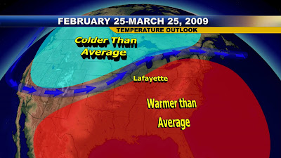
We talked about how the La Nina is still alive and that traditionally brings us an early Spring here in Lafayette. In March of 2000 we set record highs near 80 degrees on two consecutive days. Temperatures ran about 7 degrees above average for the month. This pattern may repeat itself as a high pressure ridge off the southeast coast builds in early and chases winter away early this year. If you are in Wisconsin or Minnesota do not get too excited. It looks like you will have a snowy March with even a blizzard possible. Now we always worry about severe weather if we warm up too quickly here in Indiana and I will take a look at this with you tomorrow here on the blog with forecast precipitation amounts on the way. So much to talk about and so little time. I better go run an extra few miles all over again. You have to be in tip-top shape to forecast in Indiana and of course have the best bloggers and weather watchers on earth to stand a chance. Here are a few inspirational runner's quotes to fire you up for your next workout.

"At the end of the day, you will never say 'I wish I never worked out today.”


"Run your own race."


"It's very hard in the beginning to understand that the whole idea is not to beat the other runners. Eventually you learn that the competition is against the little voice inside you that wants you to quit." George Sheehan

"Racing teaches us to challenge ourselves. It teaches us to push beyond where we thought we could go. It helps us to find out what we are made of. This is what we do. This is what it's all about."
-PattiSue Plumer, U.S. Olympian

"Ask yourself: 'Can I give more?'. The answer is usually: 'Yes'."-Paul Tergat, Kenyan professional marathoner

"The miracle isn't that I finished. The miracle is that I had the courage to start."

"What distinguishes those of us at the starting line from those of us on the couch is that we learn through running to take what the day gives us, what our body will allow us, and what our will can tolerate."
- John Bingham, running writer and speaker

"Running is a big question mark that's there each and every day. It asks you, 'Are you going to be a wimp or are you going to be strong today?'"
- Peter Maher, Canadian marathon runner

"You have a choice. You can throw in the towel, or you can use it to wipe the sweat off of your face." -Gatorade Ad


"The will to win means nothing without the will to prepare."
-Juma Ikangaa, 1989 NYC Marathon winner


I am now ready to sign up for my next marathon and I think it may have something to do with pigs or flying pigs!! There is so much for all of us to look forward to as we head into the Spring which of course includes T-Shirts and our picnic. I am still working out details on this, but it is happening. Now I am off and running!!! YES!!