Monday, June 30, 2008

A Picture Perfect Finish to A Stormy June!

The Prangley Girls having a great day at the park with Dad!

I have been at the Park with my kids and for good reason. You see the feast we had at Armstrong Park! BJ is under the table there somewhere eating up some of the scraps. I made an incredible lunch which included peanut butter and jelly sandwhiches, chips, water, and cookies. :) This was my way of saying so long to a month of June that produced 6 tornadoes and dozens of storm reports. It was a month where I was away from my family a little too much and I cannot thank them enough for their support. Julie my wife gets the "Wife of the Year Award" hands down. Today was a much needed break. We went through tons of bread and fed the hissing geese and ducks.


The geese liked the bread a little too much. If you look closely you can see them fighting in the background. At first I thought it was Megan and Abbey going at it once again since I am used to playing referee during the day. But the girls were having so much fun they didn't argue one bit which was a first. I didn't even have any complaints about the weather out at the park and ran into a lot of great folks. I am asked a lot if I mind talking about the weather and I always say of course not! I have been talking about the weather since I was 3 years old. It is not just a job to me but a way of life. Being able to share my love of weather with others is what it is all about! Everybody was asking where summer is. Well, if you look at Monday's highs it may shock you that Billings, Montana was warmer than Lafayette, Indiana. How is this possible? It is all about that La Nina jet stream that brought us a turbulent June. In this case it is blocking all the hot weather to our south and west as it takes a big dip over us in the Midwest.This theme may be repeated over again plenty of times in July. I will have more on this on Tuesday's blog.


It is hard to believe we have had only one day of 90 degrees or above in June. Well actually it isn't because Weather Team 18 did call for a much cooler summer than normal. Not to pat myself on the back....don't worry I am very humble and will always be in this business. One big reason for this forecast coming true was our rainy Spring and start to our summer. The sun's energy is being used to evaporate all of our ground moisture instead of heating the ground and allowing our air to really heat up. Remember the earth is heated from the ground and if it saturated with moisture it slows down this process. Secondly, all this evaporation is causing more thunderstorms to pop than normal which also acts to overturn or cool the atmosphere as it brings down cool air from aloft. We all know that Midwest rainfall in the summertime depends a lot on ground moisture. That we have plenty of!

Now it is now time to get back outside. This weather is well deserved and long overdue. We all know our picnic weather doesn't last too long this time of year so make sure to tune in tonight and I will let you know how long it will last and even include a sneak peak to your big 4th forecast! Today's blog song of the day is none other than U2's beautiful day!


Sunday, June 29, 2008

Special Storm Follow-Up and Update Verifies One Tornado, Several Funnel Clouds, & Roll Clouds on Friday

Picture #1

Picture #2

Bernie Chamness captured these funnel clouds (pictures #1 and #2) on State Road 26 near Jackson Highway. On Friday night I went down to Warren County to speak to people about what they saw in the sky. Most saw what seemed to roll clouds and a mix of roll clouds and shelf clouds. These clouds usually bring damaging straight-line winds and we did see plenty of large branches down in Attica and in the Williamsport area and along State Road 55 near the Big Pine Golf Course. After reviewing radar data over the weekend I think those folks at the Big Pine Golf Course did in fact see unusual roll clouds, but no funnels or tornadoes.

But farther north there was a stronger area of rotation near Winthrop, right near and along State Road 26. There was an actual debris cloud reported by storm spotters in this area that likely indicates funnel clouds did touch down as a brief tornado. This is where reports of trees and powerlines were down.These clouds above (#1 and #2) can now be verified as funnel clouds because they were taken along state road 26 where the most intense rotation was taking place and not far from where the Winthrop tornado was spotted. This can be tricky to sort out without any motion to these pictures. I wish we could make them move. But luckily I can go back to all of our weather data and pick everything apart. It takes a day or two to sort in all out but it is certainly worth it! Speaking of tricky, let us go to exhibit B or pictures #3 and #4.

Picture #3

Picture #4

Here is a double take on what it looked like in West Point. Dan Kuczero sent in these two pictures ( #3 and #4) and said there was some slight rotation and these clouds were definitely not full blown tornadoes even though the pictures seem to indicate one was forming. These pictures are good examples of what was going on yesterday in most parts of the area. Here is a common description sent in to help us out.

I was looking west from here in Lafayette over the Wabash and saw three lowered wall clouds all approaching at once...My question is, what's it called when you see a cloud moving UP? The middle of these lowered clouds (I don't want to call them scuds because they were much bigger), it had a cloud that was below it and it looked like it was sucking the lower cloud upward back into the main wall cloud. Is there a name for that? Thanks. Mark, Lafayette

They were not the typical funnel clouds our area normally sees with severe weather. These surreal scenes were commonplace across many parts of the area last night. Mark in Lafayette does a good job in describing something that looked more like a Hollywood movie with special effects than reality.

It all goes back to what type of rotation was taking place. These pictures (#3 and #4) show what appear to be roll clouds. They can take on many shapes and sizes. Yesterday we had a gust front move through with cool, dense air and this collided with steamy, lighter air that was feeding into these thunderstorms as they moved east. This created a churning effect. These roll clouds were rotating but more in a horizontal fashion than a vertical, counter-clockwise direction that we would normally see with funnel clouds. They are unusual clouds and even though they do not produce tornadoes, they have been known to cause as much damage as a small tornado.

Picture #5

Kami Edel shows nature's power with this photo off of Klondike Road in picture #5. This low-hanging cloud was part of the same cell with the strongest rotation that briefly touched down as a tornado in Warren County. So in hindsight I am thinking this also was a funnel cloud that luckily did not touch the ground here in Tippecanoe County.

Pictures #6 and #7

Here are a couple more pictures of nature's spectacle that took place above of Lindberg Village. Shelene D'Alfonso did spot some rotation in these clouds and this was also in the area of the storm that showed a distinct rotation. (pictures #6 and #7) These two pictures are not classic funnel cloud pictures, but after speaking to storm chasers about these pictures, and looking at all the radar data we are very lucky these ragged clouds did not reach the ground as a tornado. The storm was just not organized enough to put down another tornado. We did have a brief 60 mph wind gust on the southside of Lafayette near Old Romney Road, but that was the last storm report of the entire evening and was another indication of a weakening squall line of storms as it moved into Tippecanoe County. We were very lucky that is for sure. We were very close to a tornado on Klondike Road and in the Lindberg Village area.

Picture #8

The sky looked like it was falling over Old Romney Road. (Picture #8) There was a report of a 60 mph wind gust on the southside but I could not find any damage when surveying the area.
But, it sure looked scary out there and more like a scene from the Wizard of Oz.

Picture #9

Here is a picture of what it looked like a classic funnel cloud near Attica just after 7 p.m. (picture #9) This amazing picture was sent in by Emily Routzhan. It was taken by her cousin out the rear view mirror off of straight road 55. This may have been the funnel cloud reached the ground as a tornado near Winthrop, but it is very tough to see what exactly is going on from this perspective. It still is a great shot though confirming we had dangerous storms in the area.

------------------------------------------------------------------------------------------------------------------------------------------
Excerpts from Saturday blog, June 28,2008

The rest of our Saturday will feature better weather to move our way, especially after 2 p.m. We will likely see one last line of thunderstorms form today, but it looks like areas farther south and east of Lafayette will have the better chance of seeing strong storms. But this could still change so our weather team will make sure to keep you posted with any necessary crawls or updates. Sunday we will only have highs in the 70s with a few more pop up showers but no severe weather is expected. Get ready for rainbow weather since we will have splash and dash showers mixed with plenty of dry hours this weekend. We certainly had beautiful rainbows around the area. Here were some of those great pictures. I am glad we talked about rainbow weather here on the blog earlier in the week. That is one prediction that certainly came true.

Picture #10

Thank you Brian and Marcia Tolley. This double rainbow was taken near Mulberry. (#10) I enjoyed the fireworks celebration there a few weeks ago. Nature put on quite a show of its own.

Picture #11

Rebeka was working on her 4-H project when nature provided her with the ultimate prize picture. (#11) Thank you Rebeka and Melissa Bishop. Have a great day and we will look for more rainbows this weekend. Have a great day. Here is to better weather ahead!

Thanks again to the best bloggers in the world! You did a great job sending in pictures and verification of exactly what happened what not have been possible without you. Keep sending in those pictures to storm@wlfi.com to help keep us all safe and ahead of the storm.

Saturday, June 28, 2008

Mean & Green Skies Bring Unusual Clouds to Our Area, But No Confirmed Tornadoes


The rest of our Saturday will feature better weather to move our way, especially after 2 p.m. We will likely see one last line of thunderstorms form today, but it looks like areas farther south and east of Lafayette will have the better chance of seeing strong storms. I am in the process of reviewing all the data, radar shots, pictures, and eyewitness accounts from Friday's severe weather. I will have a full report coming your way by Sunday. Sunday we will only have highs in the 70s with a few more pop up showers but no severe weather is expected. Get ready for rainbow weather since we will have splash and dash showers mixed with plenty fo dry hours this weekend. We certainly had beautiful rainbows around the area. Here were some of those great pictures. I am glad we talked about rainbow weather here on the blog earlier in the week. That is one prediction that certainly came true and I see more rainbows like these below in our future.


Thank you Brian and Marcia Tolley. This double rainbow was taken near Mulberry. I enjoyed the fireworks celebration there a few weeks ago. Nature put on quite a show of its own.

Rebeka was working on her 4-H project when nature provided her with the ultimate prize picture. Thank you Rebeka and Melissa Bishop. Have a great day and we will look for more rainbows this weekend. Have a great day. Here is to better weather ahead!

Thanks again to the best bloggers in the world! You did a great job sending in pictures and verification of exactly what happened what not have been possible without you. Keep sending in those pictures to storm@wlfi.com to help keep us all safe and ahead of the storm.


Friday, June 27, 2008

We Have the All Clear in Tippecanoe, Warren, and Fountain Counties

We had some rotation reported in the clouds in Fountain County on State Road 55, but the good news is that the rotation did not reach the ground. The tornado warning has been canceled for our viewing area. But if you live in Carroll, Clinton, northeast Tippecanoe, Howard, Cass, and Miami Counties you could still be in line for severe thunderstorms this evening. The biggest threat will be damaging straight-line winds in excess of 60 mph. We had one report of an estimated wind gust near 60 mph on US231 and 800 South. So areas in our eastern area need to stay tuned for the latest.

We are checking into one report of damage on the southside at Stonebreaker Court. This was an area that saw some rotating clouds. I will get back. This was a storm that popped up out ahead of the main line so it will be interesting what we find.

Large Hail, Lightning, & Downpours Main Threats

There is a ray of hope for us! There are two lines of storms that have developed here in Indiana and it looks like the stronger line will be from Interstate 70 southward and it may steal some of the energy from our line moving through. Still stay prepared, but for now the news is good. We are still picking up dime size hail on Live Doppler 18 moving quickly into Warren County.

Thunderstorms Continue to Move our Way Sooner Rather than Later

Everything still looks on track. The timing may be a little quicker with the thunderstorms as latest trends show our best chance of thunderstorms now between 6 p.m. and 10 p.m. The good news is we have not had any storm reports in Illinois. The bad news is these storms will likely become stronger because of the clearing that has taken place here in Indiana causing the atmosphere to be more unstable. These storms formed in a more stable air mass in Illinois and this will change as they move into Indiana.

Expect a severe thunderstorm watch shortly with the main threats of damaging wind, large hail, and lightning. The Storm Prediction Center has also just come out with a mesoscale discussion confirming this for our area. Here we go again. Please warn friends and relatives that had plans this evening to have a Plan B and to have a safe place they can go to if they are out and about.

Weather Watches & Warnings Likely This Evening With Strong Thunderstorms

The sun is back out and a line of thunderstorms is forming in Illlinois. I expect it to arrive in our viewing area between 7 p.m. and 11 p.m. Here is the breakdown of the threats within 25 miles of your neighborhood.

Localized flooding 40%
Winds greater than 60 mph 40%
Hail larger than dime size 25%
Brief isolated tornadoes 5%

I will have Live Doppler 18 fired up for you and see you soon. Our Friday tradition of stormy weather continues. The weekend forecast is also showing a chance of one more line of storms on Saturday. I will let you know when we will have the all clear tonight.

WLFI is Back & So are the Thunderstorms in Your Forecast


It wasn't even Friday, but that did not stop nature from making it one of the wildest days at WLFI since the Blizzard of 2007 hit. For the first time since the great ice storm of March 1991 we did not have a regularly scheduled newscast. That was when some areas had 2 to 3 inches of ice and ice chunks the size of automobiles were falling off our TV tower. Yesterday our building was hit with a lightning strike. It wasn't just a typical lightning strike. It hit the station at 2:11 p.m. after the severe thunderstorm already moved well to our east. The radar above shows the main part of the thunderstorm was about 7 miles away, yet we still got hit. How did this happen?

This was caused by a positive lightning strike. Meteorologists separate lightning bolts into two categories which are positive and negative. The positive strikes are 8to 10 times more powerful, last 10 times longer, and their voltage is much higher at usually more than 300 kiloamperes. These positive bolts are also most likely to fly out and travel great distances from the main thunderstorm. This is what we saw yesterday. The thunderstorm top grew to 50,000 feet or about 10 miles high in the sky. The higher the cloud the better chance for severe weather and for positive lightning strikes. These are the most dangerous type of lightning strikes as we saw yesterday.


The story gets better. We even had a St. Elmos Fire effect before the lightning bolt hit. One of our satellite dishes looked like it lit up before the lightning bolt zapped it. The lightning bolt traveled from the dish to the edge of our building and it shook it. The return stroke apparently was so powerful it damaged several pieces of our equipment, including portions of our microwave tower. It is ironic this is severe weather awareness week and was a perfect example of why I always tell folks that most people are struck by lightning out ahead of the thunderstorms and after the thunderstorms move away. Yes, most people are struck by lightning when it is not even raining outside. Luckily nobody was hurt or injured. Our Precision weather computer wasn't so lucky. You can see how it flat-lined. The good news is we have it up and running in the weather center again and you should see it on the air in the near future.

I wanted to give a shout-out to our resilient staff and engineers. They gave that word true meaning yesterday by moving our main control room you see in the picture below to our traveling trailer in only 4 hours time. Many television stations across the country have been knocked off the air for days when they take a lightning hit like we did. Great job guys. This shows you how resilient our station really is.Today we will have another chance of strong thunderstorms and we will have to watch things closely as we are still in the warm sector between the cold front to our west and warm front to the north. As the cold front moves closer it will add lift to the atmosphere and increase our chances of severe weather. I think our highest risk will be in the afternoon and evening and maybe one more round on Saturday before we clear out by late day. We will not only have to watch out for lightning, but damaging winds of 60 mph, and localized flooding.

Weather Team 18 will keep you posted throughout the day. Talk to you soon. Here is the weather song of the day. See if you can guess it. I will talk more about this phenomena here on the blog in the near future.


Thursday, June 26, 2008

WLFI Knocked off the Air at 5 p.m. Due to Lightning Strike

It is kind of ironic it is Lightning Safety Week and this happens. For the first time in the more than 9 years I have been at WLFI we are not going to be able to do a scheduled weekly show. We were supposed to be on at 5 p.m. but the show has been canceled. The good news is that we are still on the air and that we will resume with our normal newscast schedule at 6 p.m. It is kind of cool how we are all rallying around one another making the most of this situation.My intern Kevin Burris picked a great day to come in to work and has been a huge help getting our Precison 18 working again. Everybody here has done a fabulous job.

I reminded my news director that we are doing very well compared to other stations across the country that were knocked off the air for several days and sometimes weeks due to severe weather. One other note is that I will not have a chroma key to do weather on this evening, but I have found a way to make some weather maps and our actual forecast computers are working again. So even though it would have been fun I will not have to get the crayons and magic markers and draw maps on poster board. I will see you at 6 p.m. I think the worst is over for the storms today, but I am still concerned once again for tomorrow night into Saturday morning for the brunt of our storms. See you at 6 p.m. and remember those lightning safety rules.

Fire Rainbows & Fire in the Sky Pattern Continues

What a wild ride it has been! Michell Huag sent in a picture of the rarest atmospheric phenomena. Yes! You are looking at a fire rainbow that lit up the sky over Purdue Research Park. This picture does not do it justice. By time she got her camera out it faded a bit, but it is still impressive. Here is another picture from northern Idaho taken on June 3, 2006. It gives you a better view of just how bright fire rainbows can be.

Now that I have your attention let me tell you why this rainbow is so rare. This is officially called a circumhorizontal arc. It is caused by light passing through high cirrus clouds that have to be 20,000 feet or higher. A traditional rainbow is caused by refracted light passing through the backside of a raindrop. The fire rainbow also needs the sun angle to be very high in the sky or about 60 degrees above the horizon. In addition, the ice crystals all have to be lined up just right with their faces parallel to the ground. When the sunlight enters through a vertical side face of an ice crystal and exits through its bottom side it lights up the whole cloud in a full spectrum of colors. Nature certainly put on a show and those brilliant colors even rival those we would see with a northern lights display at night. Although we know the northern lights is created by a whole set of different factors. Look for more rainbows in the sky this week, although I think it would be very tough to find a fire rainbow since they are so unusual.

Look for more typical rainbows like this one captured near Attica and I will make sure to post more rainbow pictures. Send them in with stories. Have you ever walked through a rainbow like I did in Myrtle Beach? I want to hear about it. Since we will have intermittent rain and sunshine for the next couple days this is the perfect set up for rainbows. Make sure to also keep a close eye out for a double rainbow.

Speaking of fire in the sky, nature gave us quite the rude wake-up call on Wednesday morning. Here is what it looked like at 18th Street and 350 South. I barely got my kids to camp before the lightning and torrential rain hit. This was caused by a cluster of thunderstorms which were part of a mesoscale convective system that rolled in. We did not meet the criteria for a severe thunderstorm warning which is wind gusts of 58 mph or greater and or nickel size hail. But there were reports of pea size hail in West Lafayette. The lightning alone should have been enough for a warning but in today's day and age the National Weather Service does not issue warnings for vivid lightning. It is my goal to some day change that way of thinking, especially since lightning kills more people in Indiana every year than tornadoes. Weatherwise, only flooding and heat waves kill more people each year. This is a good reminder for everybody since it is officially Lightning Safety Awarenss Week.

At one point we were up to 1,000 lightning bolts per hour. Here were some of those lightning bolts taken by Paul Hadfield near Decatur, Illinois before they roared our way. I followed my own advice and stayed put at the church until the storm passed. When folks try to drive around in thunderstorms it is one of my biggest pet peeves. I was driving a convertible and of course the top was up with the rain, but you have to remember you need a hard roof to keep you safe during thunderstorms. Convertibles are not safe to be in or to drive around in during thunderstorms. The metal shell of your car is what protects you and not the rubber tires. This is called the "bird cage effect". I stayed put during the thunderstorms and called Weather Team 18's Kelly Greene at the station with a weather update and also contacted TEMA director Mark Kirby. So I was able to stay safe and do my job. I knew we were in good hands with Kelly at the station so I was not going to chance it. The third point to empasize is that most folks are struck by lightning when it is not raining outside. This is because the lightning channel likes to spread out like branches of a tree and it strikes many times outside of the darkest part of the cloud and has been known to travel more than 10 miles outside of the cloud. Many times folks think they are safe when they see that the heavy rain is over or about to begin, but now you know that it is not porch time, but time to get inside and away from windows. The kids at the Congress United Methodist Church made the most of the rain delay by holding spoon and egg races inside.

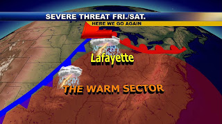
Today more storms will try to race our way and I do think we could easily see another one to two inches of rain in scattered locations around the area between now and Saturday morning. Mary Anne in Remington had .98" of an inch of rain while Randy in Frankfort only had .15". This will help reduce our chances of any widespread or major flooding but remember localized flash flooding is possible with any strong thunderstorm. Even though we should average out to one to two inches of rain their will always be that spot or two with even more. Today make sure to tune in and I will tell you why I am concerned about another severe weather outbreak here in the Midwest and when it will hit. Timing will be the key for us. I think once again we will have to watch things closely on Friday evening and early Saturday. You know the drill. There is something about Fridays and storms and with the Relay for Life going on I will fine-tune that timing for you as we get closer. As I prepare for tonight's shows here is your weather blog song of the day for you to enjoy: I've Seen Fire and I've Seen Rain by James Taylor. Enjoy and have a great and safe day! Remember you do not need to cancel plans but have a plan B so you can follow those lightning safety rules.


Wednesday, June 25, 2008

Thunderstruck in Lafayette as the Thunderheads Return


I took these photos at 9:25 last Saturday evening (June 21, 2008). They were taken across St. Rd. 16 from North White High School in Monon. I was facing east with the sun behind me. I zoomed in on the one picture to get that fiery red center.

Hope you can use them. If not, just enjoy them. We enjoy all the pictures that you show on the weather.

Nancy Harvey
Monon, IN

Thank you Nancy. I am lucky to have such avid weather enthusiasts and those pictures are absolutely beautiful examples of nature's majesty. You are looking at 45,000 foot thunderheads or cumulonimbus clouds. The warm, bouyant rising air parcels keep rising until they reach equilibrium with the atmosphere. This usually happens near the top of the troposphere where temperatures level off. This is where the warm parcels are no longer warmer than their environment. This causes the cloud to form this beautiful anvil-shape as the air is forced to spread outward instead of upward.


The old AC/DC song "thunderstruck" is playing in my head this early morning as I track storms across Illinois. Our weekend weatherman Brian Wolfe is in here tracking storms as well. He is doing a great job learning our computer systems, but does need work on his singing this song above. :) You can say the "thunder" chant in the song above sums up the weather story of the day quite well. This line of thunderstorms could produce a brief gusty thunderstorm this morning. The first line will not be too strong to start early today in our viewing area but later today we will have to watch out for a few stronger thunderstorms. We are in a slight risk of severe weather today. The main threats will be large hail and damaging wind.


Tristan Scheffer. Taken by Tristan Scheffer. Winamac, IN June 22, 2008 at 13:24.

You can see some of the hail that pelted Winamac over the weekend. It was one of at least a dozen hail reports. Unfortunately there was some damage to corn crops near Remington. A good mile of corn was flattened like a pancake. We have had an amazing 56 damaging storm reports in our viewing area since May 30th. We are averaging just over two reports per day over the past three and a half weeks. It comes out to 25 wind reports, 24 hail reports, and 7 tornadoes. This begs the question about if we will also have to worry about flooding. After all we had the worst flooding since 1913 just south of Indianapolis. The good news is I do not see a repeat of this. The main jet stream which helped a front stall with close to 10 inches of rain in some areas near Franklin is well north of the area. This does not mean we could have a few areas with over an inch of rain the next few days. But I do not see another flood event. The bad news is that more flooding is possible for areas of Wisconsin, northern Illinois, and Iowa closer to the battle zone closer to the jet stream. Our weather team will keep you updated on those "thunderheads". Make it a great day. Now back to Live Doppler 18.

Tuesday, June 24, 2008

Looking Like Winter in Winamac! Summer on Vacation for One More Day!

Courtesy of Gary Deboy

I was taking a walk tonight, I walk 2 1/2 miles every day, it was 7;00 PM 6/23/2008 and I had the camera with me, ABOUT 3 MILES S/W of Rossville. The sky was blue, the corn was green, the sun was out, with a few clouds in the sky, and WLFI TV tower is in the background, and I thought it would make a nice picture.

Yes! This is a wonderful picture and I am proud of you for walking every day. Consistency is what separates good workout routines from great ones. It is also good to see the corn doing well! Today was a day where I felt like I could run forever without getting tired as I soaked up those blue skies and enjoyed the low humidity. Usually in the summer the combination of heat and humidity adds about one minute per mile to my time. Today I gained a minute per mile and clocked in under a 7 minute mile. I felt like I had Spring fever out there today as my 4 mile run felt like about a mile! In the Rocky Mountains apparently they are also having some refreshing weather. Maybe too refreshing!

My name is Caryn Franchois and my Husband Greg took this cold, windy picture. It was a beautiful 7degree wind chill summer afternoon day on June 11th, 2008. We were on the highest road in America. Trail Ridge Road is in the Rocky Mountains above Denver CO. This little Marmot was just sitting there in the cold and he snapped the picture. It started snowing a few minutes later. It was our vacation and it is some of the most wonderful scenery in the United States, but freezing and in June.

Thanks for sending this in Caryn. I will have to add this to my list of places to see that is for sure. Temperatures drop about 4 degrees every thousand feet and with the amplified pattern we have been in this month I have no doubt the same jet stream that has brought us our stormy weather is also giving Colorado some unsual weather. I know some of the ski resorts out there were open this year later than ever before! The little Marmot at least looks warm in his or her coat of fur.

Where is summer? I did find summer across Texas and the Western states. Phoenix recorded its 14th day above 100 degrees. What I find interesting about this pattern is that I still think it will be a recurring one this summer. The hottest weather will stay in the deep South and especially out West. Here in Lafayette we will have less than our average 16 days of 90 degrees or above. I am going to stick with that forecast of 12 days of 90 degrees or above. The jet stream will be forced to detour a little farther south than normal due to the big heat out West. This will bring in more frequent cold fronts and even though I do see us drying out to near normal rainfall in July and August, the rest of the Summer of 2008 may be remembered as the Summer of Hail. I am still working on my July forecast but my latest projections still favor temperatures near or slightly below average. Look what this pattern did yesterday with unusually cool air aloft and the warm sun heating the lower levels of the atmosphere. Get ready insurance agents. This could be one of those summers. You may want to tell your clients to find parking garages for their cars.

Thank you Tristan Scheffer. This picture was taken just before 1:30 p.m. Sunday in Winamac and you could see that even though we did not get any snow like out in Colorado, the ground did have a nice white "hail" coating on it! This is a reminder that winter begins in 182 days on December 22nd at 1:08 EST. Since you know how much I love snow, I have already checked into what this winter will bring. See I do earn my pay during quieter weather. You have to keep moving to stay ahead of nature that is for sure. What I found is that some maps do have a weak El Nino developing which would favor Lafayette once again having an above average snow year. The last time we had a weak El Nino I was running around WLFI going crazy during the blizzard of 2007. Bring it on! My tradition of playing Christmas music during the summer for Christmas in July may have to be moved up this year. I am fired up after seeing this picture above and thinking about the winter forecast. Snow lovers get ready!

Tonight make sure to tune in for a reality check. Summer will make a return on Wednesday and the thunderheads will return. Could more hail be in our future? I will have your answer shortly.

Now it is time to get out, walk, run, exercise...just get out and make it happen! You can do it. Remember the 5k Zoo Run Run is coming up July 19th at 8:30 a.m. at Columbian Park Zoo. Look for a commercial with me racing not only turtles but goats. :) That is a fun story for another day. It goes back to a case of Spring fever.

Monday, June 23, 2008

Taste of Tippecanoe & Hailers Too Usher in Summer

The Shephard Family soaking up the sun, finishing up the pork loins, and ready to play some frisbee before some dessert!

It was a weekend to remember. You know its summer in Lafayette when the Taste of Tippecanoe hits town. It is our annual rite of passage as we go from Spring into Summer. The Taste of Tippecanoe was bigger and better than ever before according to most of the folks I talked to. There were up to 40 different food vendors which set a new record and it took about 400 volunteers to make this event so special. Thank you volunteers.


Your Hoosier hospitality made a difference. This party spanned from Lafayette into West Lafayette. Yes, two great cities and one great time! The John T. Meyers Pedestrian Bridge filled up in a hurry.

Things turned "gooey good" at the kids cookie-making contest!

WLFI TV-18 was out in full force with a special one hour show. Our staff wanted to get out in the community and meet as many of our great viewers as possible so we could show our appreciation of how much you mean to us. Yes, it should have been a day off for most of us, but for us this was our Indianapolis 500 only bigger!

Sue Scott, Renetta, and I enjoying our time together between live-shots.

None of this would have been possible without the big three! Way to make us look good Scott, Adam, and Phil!

It was a great opportunity to be able to not only be a part of a huge event, but just enjoy it with you with great food, music, and your wonderful company. So in essence, it was better than a day off because of all the great folks I got to meet face to face. We have the most loyal viewers you will find anywhere else. Even Smoothie King watches us! We were dancing in the streets and slapping some high-fives! I am ready for another Angel Food Cake smoothie.

We may not be the biggest station around but we are a station that can compete with anybody. We have so many talented and hard-working people and it is no coincidence that many people that move on from WLFI land in top 50 markets and in some cases top 25 markets without any problem. Yes, I may sound a bit like Matt Painter at this point but I really do believe in WLFI and our community. Lafayette is a special place that you cannot find much of anymore across our country. We take pride in being your only local station and bringing you the best local news. By meeting so many nice folks it will just make me work harder to be the best because you deserve it! Our entire staff sends a big thank you for all your support.


This weekend would not have been complete without nature trying to make things interesting. The forecast called for pop up thunderstorms that would be hit and miss and luckily for us the storms on Saturday did miss the Taste of Tippecanoe. The weather was a big reason why some event organizers called it the quickest start out of the gates ever. Some volunteers were going through 1,000 tickets per hour. The big ticket when it came to our weather this weekend was certainly the west-northwest flow bringing unusually cool air aloft over Lafayette. You combine that with a strong sun angle and we had a few places that had some hail or what I like to call "hailers" that dropped golf-ball size hail in De Motte and Grissom Air Force Base.


But in the end it was the man-made fireworks that prevailed. I have to say that it was one of the best fireworks shows I have ever seen and this includes the Fourth of July. There seemed to be at least 3 grand finales and there were even smiley face fireworks at the start. I had a great time just taking it all in with my family. Lauren was a little frightened at first but then was just fine and she really liked the pink fireworks. Abbey started worrying about some of the pyro clouds that were made from the fireworks, but I told her that she would be fine and that they would not form thunderstorms. Imagine that. Megan was amazed at how long they lasted. Now today we will get a needed break from nature's fireworks as high pressure moves in. Tune in to find out how long it will last and we will also take a look at when some real summertime heat and humidity will arrive. Have a great day.

Saturday, June 21, 2008

Thunderstorms with Heavy Downpours, Lightning, & Hail Move Our Way

You can see some of the beautiful towering cumulus clouds around the area. The good news is the morning and early afternoon rain and thunderstorms has stabilized our atmosphere enough so that we will not have to worry about any rain for the Taste of Tippecanoe! Get out and enjoy. I will see you there.

Update as of 4:30 p.m.

We have the all clear! I am heading out to the Taste of Tippecanoe and will post some pictures for you. A big thanks to Brian Wolfe for holding down the fort for the rest of today and this evening and for helping with all the severe weather crawls this afternoon. Remember we are still going to be tracking a cell with possible small hail and dangerous lightning over Fountain and Montgomery Counties. But it will not be moving into Tippecanoe. It will track southeast at about 30 mph. See ya at the Taste!


Update as of 2:21 p.m.

Still cannot give the all clear for our area and a severe thunderstorm watch remains in effect until 7 p.m. There is an unstable air mass that is taking shape in Central Illinois in the sunshine. This means we could still see a second line of storms form in Illinois and it will likely move into our area between 4 p.m. and 7 p.m. right along the rain-cooled boundary from this morning and early afternoon. The main threats will be lightning and large hail.


Update as of 1:10 p.m.

The main line of storms is dying out now as it moves closer to Tippecanoe County....the concern is that a strong second line of storms will re-fire by mid to late afternoon along the thunderstorm cooled boundary from this morning. Since this line did not make it all the way through the Lafayette area we will even have to watch things closely late this afternoon and early evening.

As of now....
News Channel 18 Weather Alert: A SEVERE THUNDERSTORM WARNING IS IN EFFECT FOR FULTON AND PULASKI COUNTIES UNTIL 2 P.M. A SEVERE THUNDERSTORM WARNING IS IN EFFECT FOR JASPER AND MIAMI COUNTIES UNTIL 1:45 P.M. A SEVERE THUNDERSTORM WARNING IS IN EFFECT FOR NEWTON AND CASS COUNTIES UNTIL 1:15 P.M. THE MAIN THREATS WILL BE HEAVY DOWNPOURS, LIGHTNING, AND LARGE HAIL. ISOLATED DAMAGING WIND GUSTS IN EXCESS OF 60 MPH ARE ALSO POSSIBLE, ESPECIALLY FROM CENTRAL JASPER COUNTY NORTHWARD. A SEVERE THUNDERSTORM WATCH IS IN EFFECT FOR MONTGOMERY, TIPPECANOE, CARROLL, CASS, FULTON, MIAMI, HOWARD, AND CLINTON COUNTIES UNTIL 7 P.M.


Update at of 12:45 p.m.

We have had two reports of nickel size hail near Rensselaer so far and another round of nickel to quarter size hail on the way. Areas from Rensselaer northward have the highest risk of seeing hail at this time. In addition, lightning tracker is picking up over 1,000 lightning strikes in the past 2 hours and another round of lightning is moving in from Illinois. I know there are a lot of folks camping and at Indiana Beach. You will have to remember to get indoors or to a sturdy structure when the thunder roars. Baseball umpires should not wait until it starts raining to call a rain delay. All fields should be cleared at the instant you see lightning or hear thunder. Things should start improving around the area after 4 p.m.


Update as of Noon...we have severe thunderstorm warnings for northern White and Jasper Counties. The main threats will be lightning and quarter-size hail. Since we have had a couple warnings due to hail the Storm Prediction Center has put a good portion of our area in a severe thunderstorm watch until 7 p.m. but I do think most of the activity should be between now and 4 p.m. I will check back.


Good Saturday morning....we do have some scattered thunderstorms moving through the area....with large hail as the main threat....we can then get on with all our big plans by later this afternoon and evening...so the sooner the rain....the better for our cookout plans tonight. I will check back with you in case anything changes. Have a great weekend!

Friday, June 20, 2008

Happy Summer Solstice No Matter What Your Calendar Says


Well this week we have already exposed the "moon illusion" in the sky and now I have to warn you about the home calendar that has June 21st as the first day of summer. Many folks are confused by this and I even found 2 calendars today that have the first day of summer on June 21st, including one in the weather office! What do you believe? Well, you have to trust in me that this year June 20th is the first day of summer and not the 21st. Why all the confusion on the date this year? Well even though most of the time summer begins on June 21st, that is NOT the case during a leap year. Yes, you've got it. Since 2008 is a leap year summer begins today on June 20th at 7:59 p.m. I already have the pots and pans ready! This tradition of banging pots and pans on the solstice began when I was young in Hyattsville, Maryland on West Park Drive. I have carried it on to this day. Yes weather people can be strange and I am no exception. Now for some unusual facts you may not have thought about.

We have come a long way since our shortest day of last year which was December 22, 2007. We only had 9 hours and 17 minutes of daylight with a sunrise at 8:07 a.m. and a sunset at 5:24 p.m. Today we have a whopping 15 hours and 4 minutes of daylight with a sunrise at 6:17 a.m. and a sunset at 9:21 p.m. Now you know how I like to dig deeper for facts you might enjoy. If you add in the "nautical" twilight we receive this time of year we have over 17 and a half hours of daylight. Our nautical sunrise is at 5:02 a.m. and a nautical sunset will be at 10:37 p.m. What is nautical sunset? First we better distinguish between twilight, civil twilight, and nautical twilight. You better get an extra cup of coffee this morning for this.

Twilight: Before sunrise and again after sunset there there is natural light provided by the upper atmosphere, which does receive direct sunlight and reflects part of it toward the Earth's surface. Some outdoor activities may be conducted without artificial lighting. The major determinants of the amount of natural light during twilight are related of course to the local weather and state of the atmosphere.


Civil twilight: It is defined to begin in the morning, and to end in the evening when the center of the Sun is geometrically 6 degrees below the horizon. This is the limit at which twilight illumination is sufficient, under good weather conditions, for terrestrial objects to be clearly distinguished; at the beginning of morning civil twilight, or end of evening civil twilight, the horizon is clearly defined and the brightest stars are visible under good atmospheric conditions in the absence of moonlight or other illumination. In the morning before the beginning of civil twilight and in the evening after the end of civil twilight, artificial illumination is normally required to carry on ordinary outdoor activities. Complete darkness, however, ends sometime prior to the beginning of morning civil twilight and begins sometime after the end of evening civil twilight. Do you have all this?

Nautical twilight: is defined to begin in the morning, and to end in the evening, when the center of the sun is geometrically 12 degrees below the horizon. At the beginning or end of nautical twilight, under good atmospheric conditions and in the absence of other illumination, general outlines of ground objects may be distinguishable, but detailed outdoor operations are not possible, and the horizon is indistinct. So you see our nautical sunset time above is not until 10:37 p.m. I think Lafayette should be called the LAND OF THE MIDNIGHT SUN. :)


So enjoy the longest day of the year which will be the first Friday in 10 weeks that we should stay dry here in Lafayette. Now that I wrote this we are doomed. I did warn folks that you cannot totally rule out a pop up thunderstorm this time of year since the summer marks the heart of our thunderstorm season. Even last night we picked up a pop-up thunderstorm near Carmel. Now this weekend I do have a chance of thunderstorms in the forecast. But I am still optimistic about more man-made fireworks than nature's fireworks at the Taste of Tippecanoe. The main course should be full of great music and food with just a side-order of pulse thunderstorms, but no supercells are expected. I will be back to explain why and the difference between them. In the meantime, here is a little appetizer or two. The yellow-shaded areas are where you do not want to be at 6 p.m. on Saturday. Notice Lafayette looks pretty good!

The supercell index for Saturday at 9 p.m. looks even more promising as the bigger, stronger thunderstorms that develop in Illinois should drop into southern Indiana.
This is because most of your lift in the atmosphere will be where the hot scorching weather in the southwest meets clashes with cooler air and higher upper-level winds. You can see on the map below this would favor the areas of heaviest rain well to our south and southwest. It will be Missouri and southern Illinois and Indiana that will have the heavier rain.

So here at home we are looking good for the Fireworks show! Any thunderstorms we do have should not last long and not everybody will see rain. Do not cancel those plans, that is for sure. I will have your thunderstorm time-line coming up here shortly and talk about a type of thunderstorm a few of us will see this weekend that is much different than what we were used to in the Spring. Tune in to find out more. Have a great day!


Thursday, June 19, 2008

Happy Birthday SUPER MOM! It's Party Time Weatherwise and Otherwise!


There is my Mom with her Hoosier grandchildren this past Easter. Happy Birthday Mom! You may live about 1,000 miles away, but you are always with me in all that I do. I certainly would not do what I love everyday without you. Everybody knows about David Letterman's Mom, but you are much better! :)You are without a doubt the best Mom I could have ever asked for and here is my top ten list of why:

10) You taught me to always make my bed even if I thought it would snow and it was sunny outside. I made sure to always throw my junk under my bed so you would be happy with me.

9) You came to all my sporting events and made sure to tell the other team not to hurt me. But they were surprised when this Momma's boy turned into the Hulk when lacing up the shoes and playing hoops.

8) You taught me how to ride a bike and I still have the proof with a tiny scar on my left knee. I must of fallen a hundred times, but you made sure I kept getting back on that bike. This prepared me for later in life when I would miss a weather forecast.

7) You helped me put out a fire in my hair after getting too close to my birthday candles one year. I watch my kids closely on their birthdays since they are related to me.

6) You did homework night after night with me and helped me win an award for my 4th grade science project on condensation. That is the only time in my life I have been able to control the weather and it was with you.

5) You took me to the library and encouraged me to check out weather books and luckily you were strong enough to help me carry a trunkload of books home.

4) You sat with me every night at the dinner table and would even take walks with me afterwards. No matter what happened that day, after our walks I felt like I had the best day ever and I could not wait for tomorrow.

3) You put me through college and told me to never give up on my dreams even when my report card was more alarming than today's gas prices.

2) You taught me how to properly hammer, clean, and eat Maryland crabs! My wife would rather me have learned how to use a hammer and tools for other things, but nobody is perfect.

1) You were the world's first Super Mom! Where do you think the term came from? You were outstanding in all facets of your life, including your job. Most of all you made me and our entire family feel special every single day after you came home after a long day at work. Where did you find the energy? Well, I think it came from you having the world's biggest heart. Thank you Mom. I love you!


Yes, it is time to not only celebrate my wonderful Mom's birthday, but this outstanding weather here in Lafayette. This is what I call California weather. Today we had blue skies, a few weather clouds, and it was nice and comfortable. Check out how beautiful the moonrise was last night.

The red moonrise last night was due to a few cirrus clouds that blew off the top of huge thunderstorms in the Plains. This was all that was left of those thunderstorms....just an extra beautiful moonrise. It is about time our Spring weather cooperates. It was one for the books and here are a few reasons why it will always be one for the books.

1) We had rain or snow an amazing 51 out of 90 days. This comes out to about 4 out of every 7 days we were tracking storms on Live Doppler 18. No wonder we started giving names to all the storm's impacting our area here on the blog.


2) The Wabash River did have some moderate flooding, but we luckily escaped the worst of the flooding. Areas south of Indianapolis near Franklin had their worst flooding since 1913.


3) We had our latest snow since 1977. So you can say that April fool's day this year came to us on April 28th!


4) We had 7 tornadoes in our La Nina Spring which was about two year's worth of tornadoes in one season. Last Spring we only had one brief tornado in White County.


5) The area was hit with hurricane force winds on at least 3 occasions. Here were our top wind gusts:


Creasy Lane- 85 mph


Crawfordsville- 81 mph


Frankfort- 80 mph


Battle Ground- 75 mph


Even though we do not have hurricanes here in Indiana locals will tell you it felt like we have already had 3.

Now that summer is here a different pattern is upon us. Make sure to tune in tonight for the newscast and I will let you know why. In the meantime since we are having "out of this world" weather, here is a link to what the weather on Mars is doing. I think you will love it! Notice even Mars has had more sunshine than we have had this Spring in Indiana, but those temperatures are a little too cold even for me!

http://www.space.gc.ca/asc/eng/exploration/phoenix_weather1.asp

See you soon and check back tomorrow for the Taste of Tippecanoe forecast and when we may see our first summer heat wave.