
Well, it has become a Friday tradition at WLFI. Tune in for the latest on severe weather and heavy rain amounts. This heavy rain has swelled the rivers near Indianapolis to record levels that have even surpassed the once unthinkable levels of 1913. You see the gray areas in the photograph above from NASA that show the flooded areas before and after last Friday's deluge. The latest model runs in tonight have confirmed our worst fears and that is more heavy rain is on the way for Indiana. Here is the latest rainfall forecast. 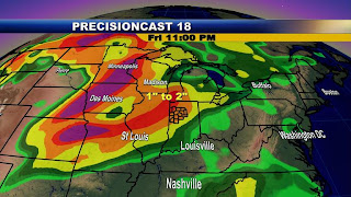 You can blame the La Nina once again. Here was an update on the La Nina sent to our weather team yesterday from Purdue's state climatologist and assistant professor of agronomy and earth and atmospheric sciences, Dev Niyogi.
Dev believes La Niña's control of the weather pattern will continue to make Indiana's normally severe storm season more intense and generate storms more frequently than average. "Whenever we are in a La Nina pattern, there is increased propensity for severe weather over Indiana during spring and summer with increased likelihood for thunderstorms and rain," Niyogi said. "We are nearing the end of the La Niña cycle, which started last year, but the sea surface temperatures are still about one-half a degree cooler than normal." As a result Dev is thinking La Nina may still have an impact on our weather at least for the rest of June and maybe even July.
The latest take on this from the Australian weather bureau is much more favorable for things improving for us in the near future. Here is their latest La Nina update mate!
Summary: Pacific ENSO-state neutral, but ocean warms
Pacific climate patterns remain neutral, although some aspects of the 2007/08 La Niña lingered in the western Pacific during the past fortnight. The tropical Pacific has been warming gradually during the past few months, with central Pacific temperatures now near-normal and eastern Pacific temperatures about one-half to one degree warmer than average.
The warming in the east has been caused in part by a weakening of the Trade Winds in that region, an effect that has been gradually spreading further west during the past several months. In addition, the Southern Oscillation Index (SOI) has been falling and now sits a little below zero for the past 30 days.
Computer model predictions show central and western Pacific temperatures continuing to increase over the next two seasons, but mainly remaining less than about 0.8°C above average, that is, neutral. No model is predicting a return to La Niña conditions, and while the chance of an El Niño developing is small, it can't be ruled out, especially as ENSO events can evolve rapidly at this time of the year.
 This is something I will keep a close eye on. I think La Nina is winding down and would be surprised if it continued to wreak havoc on our weather into July and August. This is based on many other atmospheric factors that meteorologists look at which includes sea-surface temperatures in the Atlantic basin. These factors should help overwhelm whatever La Nina has left. The latest La Nina graph from region 3.4 has it even warmer than a half-degree below average. The dark zero line above is considered average. You can see the tremendous rebound in ocean temperatures above. We have dug ourselves out of a huge hole. This graph courtesy of the Australian Weather Bureau also shows another interesting footnote. Do you see the big mountain peak on the graph above and how it quickly came crashing down. This was one of the factors that helped cause our great blizzard in February of 2007!
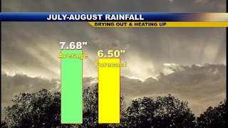
The big factors to focus on as we head into July will be the extremely warm waters in the Atlantic Ocean and Gulf of Mexico. We are in a positive AMO or what is called a positive Atlantic Multidecadal Oscillation. You can see this clearly above. The darker yellow and orange water colors indicate where it is above average while the deep blue colors show below average water temperatures. It is hard to find much blue in the Atlantic or Gulf. This is telling me a huge ridge of high pressure will take over the weather pattern in July and August. While it will not be a permanent fixture like we saw last summer, it will act to dry us out and heat us up with an average of at least 1 to 2 90 degree days per week by early July. Rainfall will decrease considerably, but certainly there will be no drought to worry about this year. Here is my latest rainfall forecast for Lafayette.
I do worry about east coast hurricanes this year in this type of set-up and have to even wonder about not just the Carolinas being hard hit but area even farther north from Maryland and Delaware to New York and New England since hurricanes love to "ride these ridges".
Back closer to home, even though my forecast is promising in the long-term, there will still be some big bumps in the road here in the short-term. It has been a deadly night in the Plains with at least 6 fatalites due to tornadoes. This system will start to move our way on Friday. Join me tonight for the latest on what you can expect here at home. 
Notice there were over 300 storm reports of damage across the country. Our thoughts and prayers are with those that have lost everything due to storms and flooding. Iowa is seeing flooding right now much worse than they did during the great flood of 1993 and you can add Wisconsin to that list. When great flood and storm years are brought up in the future you will certainly have to always include 2008 and we are only have way through the year. God bless!
8 comments:
So can it really be true? Is Mrs La Nina going back to where she came from at the end of the month? :)
Looks like this Friday night storms
could cause more heavy rain! My heart goes out to those South Of Indy.
Does anyone know how many Storms in a row, we have had on Friday's? Seems like every time I make plans,they are runied by Storms!
Well everyone more storms on there way and here is what my map's say for now but do remember this can still change. We are in a slight risk for severe for tomorrow main threat will be heavy rain larg hail and strong wind so far the time for all this to start is between 4:00pm and 9:00pm for the strongest however we could see some sca-thunderstorms early tomorrow morning around 5:00am. Again as you all know so far all the storms we have had have changed just before thay have got to us so this just gives you an idea.
Justin in Lafayette.
I heard the most hilarious thing this evening and I just HAD to pass it along!
After my daughter's gymnastics practice tonight I told her that her reward for doing so well would be dinner at Burger King (that, and I was lazy and didn't feel like cooking!). A little boy was sitting in the chair in front of me, he looked like he was maybe 5 years old, and he turned to his mother and said "we need to go to McDonalds tonight because there is a tornado comming tomorrow!"
When his mother tried to explain to him that it wasn't 100% certain that Lafayette would be hit by a tornado tomorrow, but that we are suppose to get bad thunderstorms, he wouldn't listen. He was very insistant that he HAD to go tonight because it may not be there tomorrow! I felt a little guilty brining up the topic in front of her son. Having 3 kids of my own (as I know you do too), I know how much they tend to beg sometimes when you mention fast food!
I just thought it was cute and that you would appericate the story being a parent yourself!
Hope you're out enjoying this wonderful weather in between newscasts!! I'm off to scrub more toilets!! HAHA Have a great evening!
Cute Story, witty little boy! My little one is 15, has and still comes up with a reason to go out for fast food. :]
Wow, sure hope that little boy was not being prophetic!
I am SOOO tired of tornado warnings and severe wx!! NWS just issued a tornado watch for counties S-SW-W-N of Chicago, coming close enough to my area we could see leftover storms after 2:00 a.m.
I long for calmer wx!!
Humidity was very oppressive today!
Mary Anne in Remington
oh crap I just realized that I think my car windows are down and have been all night..ahhhh
anyways...the friday thing is weird lol. I hope no horrible weather happens today/tonight and sound like my sister national guard bf might be still doing work south of Indy.They are helping with the floods.
Post a Comment