I am checking in before Kelly Greene's going away party! She will be dearly missed and the good news is she will not be far away in Fort Wayne. Kelly joined us as a part-time weekender about 4 years ago and has blossomed into a wonderful meteorologist. I will miss all of our laughter and yes even our heart to heart sessions when forecasts did not go quite the way we thought. This is the hardest part of this business...when you see friends come and go. I will never forget digging her car out in the blizzard of 2007 and she will always be a part of our WLFI family. I know she will make us proud in Fort Wayne. Way to go Kelly!
In the world of weather I finally get to show you rainfall tonight. If you take out the big rain we had earlier in the month it is our driest August since 1996. Some lucky dogs got .25" of rain but that was the exception to the rule and our best bet for rain over the next couple of weeks will be from what is left of major hurricanes that will likely hit the United States. All interests from the Gulf of Mexico, Florida, and even up the East Coast will have to monitor things very carefully. Right now I see two hurricanes making landfall in the next 7 days and maybe two more on the way by the middle of September before things settle down. I will have their tracks on the news tonight and post the latest on the blog. Also, keep cool thoughts because our hottest weather of the season is on the way. Here is a good way to keep cool....
Snowfall is still looking slightly below average for us this winter with milder than normal temperatures moving in after Christmas and continuing through much of January and February. Our biggest snowstorms this year could very well be in November, December, and March. It is fitting that it will be another strange season. The autumn outlook looks like we will stay drier than average through October before we get our rain and snow that we are used to in November and through much of the winter. We will still have an early frost in September, but also plenty of Indian summer in October. More details on the way....we will name all the snowstorms this year just like they name hurricanes....send in names..I will have the forecast number of snows and monthly totals posted this evening. Things will start getting back to normal here on the blog. I have my second wind and I have a thousand things to write about! Have a wonderful weekend!
Friday, August 29, 2008
Thursday, August 28, 2008
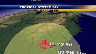
Rain Falls Apart Again, We May Have to Wait on Gustav
 It was a beautiful start to the day in Rossville. The fog was quite thick in some areas. The old weather proverb says a red sky at night is a sailors delight and a red sky in the morning sailors take warning. But not in this pattern. Tune in at 5, 6, and 11 to find out why and I will have the latest track on Gustav and why it may be bad news for the Gulf Coast but good news for us bringing us our next best chance of significant rain! Oh yes!! I finally have finished all of the research for our winter outlook...will it be another 1977-78 when we had 56.5 inches of snow or will we pull a 1976 out of the bag with about 27 inches of snow on the way. So much to talk about, so little time, but I will have more on this here on the blog. Thanks for your patience. You know this snow lover does not take these forecasts lightly.
Wednesday, August 27, 2008
Fay Finally Arrives in Lafayette, But Still No Rain

Here is a nice picture just sent in from the wind farm just east of Fowler. This is what you can expect here in Lafayette this evening. You can thank Fay for a beautiful sunset on the way with plenty of high cirrus clouds helping to bring us a dazzling display. I don't think I have ever been so excited to see clouds when they rolled in this afternoon. I even took Lauren outside to show her and tell her that this was part of a tropical storm that brought over 30 inches of rain to Florida. Unfortunately, the tropics are not done and tonight I will show you where Gustav is heading and why there are a couple more hurricanes behind it. We will see Hanna form this weekend in the Atlantic and that could very well be an east coast hurricane by later next week. Now back closer to home you can also blame Fay if your garden is drying out. Still no rain is expected and the heat is on in this forecast. I will have more on this and how many snows you can expect this winter. Now its off to see and talk to some boy scouts.
Tuesday, August 26, 2008
Lafayette Winter Forecast Not Looking "Catastrophic"
Well, I worked on the winter forecast once again since I have been getting swamped with e-mails on why the two big almanacs that come out this time of year are calling for snowy and cold weather for much of the country. I can tell you that I do not see a historic winter setting up and nobody loves winter weather more than I do. The big thing I do see in the long-range maps is uncertainty on how strong the El Nino will be and if it develops. This will be huge in determining how much snow and cold air we receive. I do see water temperatures starting to rebound quickly out in the equatorial Pacific and this indicates my original forecast of a cold November and December with snowy weather giving way to an early Spring and warm new year still holds. I will explain more here in a bit and why this dry pattern we have having may be here to stay.
Monday, August 25, 2008
Back from Baseball Paradise With A Slice of Heavenly Weather

What a beautiful start to our work week here in Lafayette. Here was the view from Wrigley Field yesterday afternoon where it was perfect baseball weather. It was sunny with a game time temperature of 72 degrees.I made sure to bottle up some of that nice weather and bring it home with me and today here in Lafayette was certainly picture perfect. The Cubs ended up beating Washington 6 to 1, but the game experience meant much more to me than the score and yesterday this native Washingtonian was a Cubs fan and adopted into the Cubs family. How can you not want to root for the Cubs? My first time at Wrigley Field was unforgettable. The ivy walls are much better to see in person than on TV and the only thing I can compare this experience to was when I got to go to Lambeau Field to see Brett Favre play against the Redskins last October. But after being at Wrigley Field I can easily say it was the best sports stadium and place I have ever visited. Lambeau Field I would rank a close second and if you are a sports fan both of those places are a must-see! Hopefully my wonderful relatives in Wisconsin forget to read the blog today. I am in a world of trouble now. Hopefully they still like me for who I am. :)

It all started with a wonderful bus ride from Lafayette. I got to meet tons of nice folks and huge Cubs fans from the Lafayette area including Flora and Kokomo. My job was to bring nice weather and keep it nice or I would have to walk home. Luckily the weather worked out! I want to thank Jim Newell and Jim Calloway of Imperial Travel for making it a day I will never forget. Jim Newell who I like to call "1936" since he has great stories of our most famous heat wave ever to hit Lafayette was our tour guide and I learned a lot not only about baseball but about Chicago including where Dick Butkus went to school, where Ann Landers used to live, and where the world's largest apartment building is located. The ride went fast with all the tidbits of information including just how many great parks and museums make up Chicago and we even found some palm trees on the beach off Lake Shore Drive. As we drove into Wrigleyville as it is called it is like you are going into a different country. There were waves of people wearing Cubs shirts, tons of restaurants and bars, and an atmosphere like none other. It was almost like stepping into one big Mardi Gras party. The statues of Ernie Banks and Harry Caray are near each other and then you go under one of the world's most famous signs that says Welcome to Wrigley Field. It gives you goose bumps. You then proceed into the stadium where you are greeted with a Hack Wilson banner. He still holds the record with 190 RBI's in one season. The stadium is just full of history and the field is pristine. I could go on and on but let's just say that I am a changed man and it is for the better after yesterday!

Speaking of change, we have plenty of weather changes this week and our musical seasons will continue like we saw over the weekend. We have a wintry jet stream, a blocky look to the upper-levels, the remnants of historic Fay, and yet another hurricane on the way that may impact Florida or the Gulf of Mexico by the weekend. So stay tuned we have a wild rollercoaster ride on the way and I will post more on this here tonight and even include a winter weather update since a lot of folks are reading almanacs that are painting our winter as one of the worst we have had in a long time. See you soon!
Friday, August 22, 2008
Heaviest Rain in 18 Days Pounds Part of the Area, Jacksonville Goes Under Water

It has turned into a stormy day for some of us with rainfall closing in on one inch of rain here on the southside of Lafayette. The good news is the upper-level disturbance bringing this rain will continue to shear out and weaken as we head through the evening with the next batch of thunderstorms expected to be closer to the main front back in Illinois. I still think things will improve as we head into our Friday Night frenzy forecast. Make sure to tune in for the latest on Live Doppler 18. I do not expect a repeat of this on our Saturday. So do not hit the panic button. I will explain why tonight at 5,6, and 11.

The latest check on Florida is not good with tornadoes being sighted from Ponte Vedra Beach to the World Golf Village. These places I mention were all the areas where my family was vacationing at just a few weeks ago. You see us on the beach during the better days before Fay hit. I did notice the weather was bizarre when we were there with unusual rain and disturbingly low pressure for that time of year. I was worried this would make my old stomping grounds a target for tropical systems. My fears became a reality today with tons of power outages hitting the area with very few traffic lights working from the Beach to the Downtown area. This is due to tons of huge oak trees toppling over. Wind speeds of 30 to 50 mph with a saturated ground is not a good combination for those beautiful trees. Powerlines are on homes, cars, and front lawns. Folks are trapped in their homes as a result of these hot wires. Up to four inches of rain per hour hit the area with some localized rainfall now surpassing 14 inches in part of Jacksonville. The St. Johns River is becoming a beast as it approaches high tide this afternoon and is well out of its banks. It is feeling the effects of a storm surge of up to 3 feet along along with those record-setting rains. The river has white caps at this point and looks more like the Atlantic Ocean. The water simply has nowhere to go and I am very worried about many of my favorite places to go being washed away with a clean-up that will last not just months, but years. This tropical storm will go down as one of the worst tropical storms on record and is causing the worst flooding in Jacksonville since 1964.
Evacuations are now taking place from Riverside, San Marco, and the Avondale areas along the St. Johns River. Even areas inland from the ocean and away from the river are now going under water which includes the University of North Florida. The JTB/Gate River Parkway ramp looks more like a river and is closed. If that is not enough another tornado warning has gone into effect at my alma mater. So my prayers go out to all my friends and family and I have not been able to get a hold of my parents. My Dad sent this picture of the Prangley palm tree below before Fay moved into Duval County with devastating feeder bands bringing flash flooding and tornadoes. Things went downhill in a hurry late last night as Fay will go down as one of the most unique storms ever and likely one of the toughest storms ever to track. It has certainly played havoc with all meteorologists and forecast all across the country including here at home. Just look out your window. Not one model showed what happened out there today. We can blame Fay.

I do think another 3 to 6 inches of rain is not out of the question for parts of Jacksonville. The good news is Fay is moving westward which should help end the worst of the torrents of rain over Jacksonville. Where will Fay go.....possible back over the Gulf of Mexico which could allow it to build strength and maybe swing up our way by the middle of next week. What a storm. God bless! I will see you soon.
Thursday, August 21, 2008
How About them Dogs! The Dogs Take over the Town & Make a Difference!

It is good to check in with you. I cannot thank you enough for all your support at the Hike with Your Hound event last night. The dog days are certainly back in our forecast with plenty of humidity and the dogs certainly took over Columbian Park last night transforming it into Bark Park. There was a record turn-out yesterday for the big event! There were over 200 four-legged friends that showed up with their owners helping to raise enough money for Addy Demaray. She is a 4 year old that suffers from a rare disease that causes seizures. Addy's angels came through for her in a big way last night. She has more than one guardian angel that is for sure. It is just another great example of what makes this area a special place to live. This event was for free, but folks eagerly gave donations to help raise enough money for Addy to be able to have a service dog. Mission accomplished! Addy can now go outside and play when the weather is nice without worrying about having a seizure that can cause her to bump her head or have another serious injury. The service dog she can now purchase thanks to last night's walk will sense the chemical change in her body alerting her to go inside before the seizure keeping her much safer. I spoke with her Mom Megan who shed many happy tears. Addy's Dad currently serving in Iraq could not be there but he certainly was there in spirit and would have loved to see all the support. The poster you see above says it all!

It was not only a touching evening but it was a ton of fun. I enjoyed being a judge at the pet contest at 7:30 p.m. with Sheila Klinker, Tony Roswarski, and the Doctor. It was a much tougher job than I remember it being last year. You can see one of the dogs in the smiling contest above. Now that is how I smile after a snowstorm and sums up the mood last night! The weather was perfect.

The pet tricks were very impressive and it included dancing dogs. I was trying to take notes before my Arthur Murray dance lessons begin. I have always wanted to learn to dance and if the little dog above can do it so can I. My grandmother was a dance teacher so I know I have it in me! More details on this new big adventure of mine will be coming your way on this blog in the weeks ahead.
 This picture I snapped came out a little blurry but I still think you can see the resemblence in the pet-owner look-alike contest. You are certainly looking at the first place winners without a doubt. It was the only easy call we had as judges all night long.
 The costume contest was won by the pirate dog and I think he would give Johnny Depp a run for his money. The Dogs of the Carribean would be a great sequel, don't you think! There was also a clown dog we loved and of course the dog dressed in Purdue colors. Boiler Up!
 My favorite part of the night was when Lucy the therapy dog you see above jumped over my back. No, I was not standing and I became her prop by crouching over and doing my dog imitation. It certainly made me laugh. Lucy needed two jumps to clear me but successfully jumped the weatherman. It capped off a wonderful evening. Lindsey House did another great job this year and I cannot wait to get out there again next year.
Now last but not least I spoke of a tornado dog hero out in Benton County where the tornado hit just over two weeks ago! Here is the great story.
Mike,
Anne and I went out to shut the doors on the toolshed around midnight. It was calm, but the lightning was getting closer and really putting on a show. As we walk out to the toolshed, Sadie was nipping at out fingers, which she rarely does. At times she will nip at the boys clothes but never on Anne or mine. Which lead us to believe we were in for something. Sadie was in the shed with us while we shut the doors and all the way back to the house she was nipping at our clothes and our fingers. When we were back in the house we turned on the TV and weather radio. Shortly after we turned the weather radio on, we heard that there was a possible tornado around Freeland Park, headed towards Boswell. That is when we made our decision to get the boys and head for the basement. Sadie was born October 8, 2007, so she was 10 months old. She is an Australian Sheperd. Hope this is helpful.
Sincerely Brad Harman
Thanks Brad! I will make sure to post Sadie's picture. I wish all of our human viewers were like Sadie and they heeded the warning when those sirens go off! I did snap the heroine's picture and will post it here on Friday. Now are you ready for some football? Will there be more points than rainfall and can you keep those weekend plans? Tune in tonight for more answers and I will talk to you soon here on the blog.
Wednesday, August 20, 2008
Pooches and Humidity
Hello Everyone,
This is Kevin (Mike's summer intern) filling in for Mike while he's doing a live shot from Columbian Park with the Hike with Your Hound event. There's going to be a lot of vendors at the event promoting hound-related health. Several demonstrations, games, and contests are in store for this fun evening for you and your best friend. The event is free, but 5 dollar donations are suggested for participants to the Dog Park Association of Greater Lafayette, which will donate proceeds to Pawsibilities Unleashed, a not-for-profit organization that is working to raise funds to purchase and train a working dog for a Lafayette youngster. Four-year-old Addy suffers from Dravet Syndrome which causes her to have seizures. Her working dog will be trained to recognize the symptoms of her seizures, and alert an adult immediately, so your donations are appreciated.
On the weather front (no pun), we are tracking some storms in south western Illinios, but they aren't expected to move into Indiana as they are spinning counterclockwise around a low pressure center currently in Oklahoma. A complementing high pressure center is over the New England area that is going to funnel lots of moisture into our area tomorrow. Though most of it will end up in Illinois, we will still have a heat index in the mid 90's for tomorrow. July is the hottest, but August is humid, and we are going to fell it tomorrow. Stay cool, and remember to hydrate throughout the day!
Tuesday, August 19, 2008
Fay Likely to Strike Georgia-Florida Border Late Week Delaying our Rain
Here is a note I just sent to my parents down in Jacksonville, Florida. Of course my thoughts and prayers are with everybody down in Florida and Georgia. Notice the NHC track as of Tuesday at 5 p.m. has a category one hurricane going through the heart of Jacksonville on Thursday. Luckily we are still two days out and I expect this track to change once again to much less populated areas to the north and of course away from my friends and family.
THE MODEL OF CHOICE:GFDL MODEL (WILL POST NHC TRACK HERE BY 5 P.M.)
THE MODEL OF CHOICE:GFDL MODEL (WILL POST NHC TRACK HERE BY 5 P.M.)

PROBLEM: FAY IS NOW BECOMING BETTER ORGANIZED OVER LAND WHICH I HAVE NEVER SEEN HAPPEN BEFORE...UPPER-LEVEL HIGH PRESSURE IS NOW BUILDING OVER IT WITH GOOD OUTFLOW NOW SHOWING UP ON THE LATEST SATELLITE IMAGERY. THESE LIGHT WINDS ALOFT WILL ALLOW FAY TO BECOME MUCH STRONGER ONCE IT RE-EMERGES IN THE ATLANTIC OCEAN BY WEDNESDAY MORNING.
SINCE FAY IS MOVING OVER SWAMPLAND OVER THE NEXT 12 TO 18 HOURS IT SHOULD STILL HOLD TOGETHER QUITE WELL....YOU CAN NOW EVEN SEE AN EYE FOR THE FIRST TIME WITH WIND GUSTS OF 78 MPH BEING REPORTED NEAR LAKE OKEECHOBEE. FAY IS TRYING TO MAKE A MOVE TOWARD FLORIDA'S BIGGEST LAKE AND WITH PRESSURES FALLING AND I DO NOT EXPECT THE WIND SPEEDS TO DIMINISH MUCH AT ALL.
STRENGTH & TRACK FORECAST: ONCE OVER THE ATLANTIC OCEAN AN EXPLOSION TO A CATEGORY 2 HURRICANE IS LIKELY....( WIND SPEEDS WILL GO UP TO NEAR 100 MPH SUSTAINED WITH A LANDFALL BETWEEN MAYPORT, FLORIDA AND BRUNSWICK, GEORGIA...WIND SPEEDS IN MANDARIN, FLORIDA FARTHER INLAND WILL BE FROM 40 TO 50 MPH SUSTAINED WITH GUSTS TO 75.....GUSTS AT THE BEACHES (PONTE VEDRA, JACKSONVILLE BEACH, ATLANTIC BEACH COULD REACH NEAR 90 MPH WITH SUSTAINED WINDS OF 50 TO 70 MPH....FARTHER UP THE COAST CLOSE TO THE FLORIDA-GEORGIA BORDER WILL BE THE BULLSEYE...WIND SPEEDS SUSTAINED OF 80 to 100 MPH WITH GUSTS TO 110 MPH....BIGGEST STORM SINCE DORA TO IMPACT NORTHEAST FLORIDA....1964....ALTHOUGH THAT STORM MADE LANDFALL NEAR ST.AUGUSTINE WITH FLOODING AS THE MAIN PROBLEM. FAY WILL BRING NOT ONLY SOME FLOODING CONCERNS BUT PACK A PUNCH WITH PLENTY OF WIND.
What this means for us here in Indiana.....this big tropical system that is getting stronger will mean more sinking air around its periphery causing our high pressure here at home to be much stronger than what we are used to this time of year. I will check the record books for record lows as I cannot rule out some upper 40s in this type of set-up. Remember everything in the weather world is related and it takes something big for this to happen and Fay certainly fits that bill. Not only will we have a monster high pressure that is stronger, but it will be slower to move out. This will delay our rain chances likely until late Saturday or Sunday.
Next week here in Indiana we could see another strange week with another hurricane approaching the southeast coast. This hurricane may be even stronger and all interests from Florida to the Carolinas need to take note.
Toughest Forecast of the Year Should Yield Some Rain this Week


Happy Birthday to Megan our oldest daughter who is 11 years old today. She has come a long way from Myrtle Beach and every year just keeps getting better!!
The question is not if but how much rain and when over the next 7 days. If you have been wondering where I have been....well we had Lauren's first day of pre-school on Monday and a parent-teacher orientation on Monday night between shows. When I have not been tending to the kids I have been calling Florida to check in with friends and relatives. The good news for Florida is that Fay will spare the peninsula the worst of the winds. The biggest concern will be flooding with some areas easily surpassing 10 inches of rain. I cannot rule out localized about of 20 inches which would be about 8 months worth of rain here in Indiana. Also, isolated tornadoes would be the next main threat. It is not out of the question that Fay could go back out over the Atlantic and make a second landfall in Georgia. It may have stronger winds with the second landfall as a result. Stay tuned! Here are a few reasons why. Take a look at how drastically the model tracks have changed since Friday above. It looked like an Atlantic hurricane, then a Gulf Hurricane, then both, then a Gulf hurricane and it may end up as a mix of a Gulf and Atlantic hurricane. If you think daily forecasting is tough enough here in the Midwest just try adding tropical forecasting to the mix. These track changes are unbelieveable and the big thing is that what happens with Fay will certainly impact us with either a lot of rain or very little rain. Right now I am in the middle and should have more answers during the day today so check back. Today we could see at least an isolated shower or storm from Monticello northward due to a weak backdoor front coming through. This will only reach about 20% of us. The best chance of rain for us will be late week as what is left with Fay moves our way. Notice the cone of concern below. Notice it is expected to slowly drift northward by late week bringing us better chances of rain. Have a great day!
 Developing...
Monday, August 18, 2008
Florida Braces & The Midwest Stays on Standby
Talk about different opinions. Their is huge disagreement in the models as to where Fay is going and it is also playing havoc with our forecast. This may be one of the toughest forecasts I have put together all year. But I am up to the challenge....
Developing....
Developing....
Sunday, August 17, 2008
Faye Heading Farther West Means Heavier Rain for Us

The green and purple lines you see on the map are closer to where I think Fay is moving. The NAVY NOGAPS AND BAMM models I think are doing the best job at this point. This would bring Indiana heavier rain by late week. The track will mean the difference between seeing 1 to 3 inches of rain or just a few sprinkles. Some models are even showing Fay stalling out over the southeast which would effectively help end their drought. Stay tuned and I will have more coming up for you on Monday. I have already been on the phone with relatives in Florida talking about a farther west track. Our cool high of 82 today is the first sign of this. The cooler it stays this week the heavier the rain. I will explain more here on the blog and make sure to tune in tonight at 11 p.m. Brian Wolfe will have the latest. We have been working on this all evening. Now I had better get home. Have a great evening.
Friday, August 15, 2008
Tornado Dog Gets a Nice Rest With Our Finest Friday in 4 Months!
Good Morning! What a great way to start off the day. I am getting used to the new back to school schedule like all the other parents. The kids have adjusted wonderfully. I am still getting there. It takes us older people a little longer I guess. I was a little groggy this morning but after walking outside the weather really has me pumped up for my morning run! I am thinking 8 miles today.
We are going to have our nicest Friday weather in 4 months! We will never forget how we had severe weather and rain for like 100 straight Fridays! Well it wasn't that many but at one point we had rain on 12 out of our last 14 Fridays. There will be no Freaky Friday this time around and the big news is that we have Friday Night Frenzy tonight on WLFI for the first time since last March tonight! We have great "football weather" for all the scrimmages. In other words it will once again feel like autumn out there and instead of nature blitzing us with uncomfortable heat and humidity or thunderstorms and it will be just right with cool breezes, clear skies and temperatures in the lower to middle 70s early this evening. The sports team is all geared up and we will have plenty of highlights tonight from West Lafayette, Mc Cutcheon, and Jeff and that is just a small sample.
Today's weather is also just the beginning of a beautiful pattern. We have a huge double-barreled high pressure coming down from Canada. This is the same system that has really controlled our weather for much of the month of August and has helped to divert the jet stream about 1,000 miles farther south than where it should be. We have only had 2 days of rain in August with cooler, more stable air in place and has helped continue our streak of having no official 90 degree weather at least at the Purdue airport has reached an incredible 67 days!
Usually we are under the influence of a Bermuda high pressure this time of year with plenty of heat and humidity. Having a 90 degree day this time of year is as common as firing up the grill or eating some sweet corn on the porch. Well not this year and I am still concerned about an early frost around September 23rd. The forecast is for an early Frost, an early snow, and maybe a mild winter with an early Spring. There are plenty of mixed signals as we head into 2009 and our winter so stay tuned. Chances of a cold autumn is looking likely at this point. Summer is not totally done yet as the Bermuda High does show signs of making a comeback in our forecast the last week of August and for Labor Day. So if you are looking for hot weather you will have to wait awhile. In the shorter term, the East Coast will still have to watch the tropics carefully and an active tropics usually means a slow-moving weather pattern for us. This is good news if you like sunny, comfortable weather. For those that missed out on the rain yesterday you may want to water the plants because our next chance of rain may hold off until at least the middle of next week and even that is no guarantee. It was very strange yesterday with areas between Lafayette and Battle Ground not receiving a single drop of rain while other areas toward Shadeland picking up between a half-inch and one inch of rain. Luckily, I have not had to water the lawn once this year and the tomatoes have loved the weather we have had this summer. This is an understatement!
I wanted to thank our weather watcher Marty from Otterbein for bringing in some fresh Better Girl tomatoes yesterday. My ham sandwhich never tasted so good last night and they were the sweetest tomatoes I have ever had. Now I am hungry for some BLT's even if it is before 9 a.m. You do not even have to put those tomatoes on anything they are so delicious. Okay, let's keep the good news coming!
Let's get right to our skylights for the weekend:
Tonight look for Saturn, Venus, and Mercury all bunched up in the sky together after sunset. Remember planets do not twinkle, but stars do in case you have trouble identifying them.
The moon will be playing tag with Jupiter which of course has a big storm raging on its surface that is 3 times the size of the earth and has wind speeds close to 250 mph.
Speaking of the moon we will miss the lunar eclipse unless you are heading to Europe for the weekend. But we will not miss out on the FULL RED MOON which is officially Saturday night. It will be a great night for all those heading out to the Indiana State Fair. Nature has you covered along with all the great food and displays
Last but not least have a wonderful Friday and like Teri reminded all the bloggers, it will be a great day to go to the Humane Society Garage Sale to help raise money for those special animals. I will make sure to post an animal hero here on the blog by this afternoon and some other pictures. This dog actually herded her family and warned them that bad weather was on the way last Monday night before the tornado hit Benton County. My nickname for her is TORNADO DOG! Thanks for reading and I will check back soon.
Thursday, August 14, 2008
Our Stranger Summer Just Keeps Getting Stranger!
We have to start off this morning with a song from the Twilight Zone. Snow is in the forecst in northern Wyoming on Friday night which is only about 1,200 miles from Lafayette and at the same time we have no 90 degree weather even close to us. A nor'easter is heading up the East Coast. Florida has had damaging thunderstorms due to a cold front nearby. Normally this does not happen until October. The big threat for Florida by early next week will be a hurricane. There could be not one but two hurricanes forming in the next 10 days. I haven't even gotten to the 110 mph jet stream howling into the Tennesee Valley from the northwest. What season is it? You could make a case all of our upper-level maps are looking like a mix of autumn and winter. The developing hurricanes will be a reminder that it really is still summer. I will have more on this bizarre pattern and the Purdue's back to school forecast. Boiler Up!

 Developing!!
Wednesday, August 13, 2008
Autumn Pattern Brings More Meteor Showers than Rain Showers & Rare Funnel Clouds

Good morning! Here is a nice picture to start your day off on the right foot. This should wake us all up. Thank you Marty Sloan for sending in this picture of a shooting star over Wolf Park during the Perseid meteor shower on Monday night. Look just above trees. You can see why the wolves and humans were howling over nature's dazzling display. I did get to see one bright, slow-moving shooting star while walking the dog. There were even some high cirrus clouds and some neighborhood lights to contend with but they were no match for nature's big show.

Michael Phelps was once again the talk of the Olympics last night as he continues to strive for perfection and here at home nature just did not want to be outdone. We also had reports yesterday evening around 8 p.m. of 2 cold air funnels just north of Newton County at the Interstate 65, route 2 interchange that caused a big raucous on the scanners. Mary Anne in Remington immediately notified me from her Best Weather Network and I cannot thank her enough. Remember doppler radar does not pick them up as they are too small and isolated. Take a look above at the cold air funnel that was spotted in Tippecanoe County back on June 12, 2003. These cold air funnels are usually harmless and occur in the early Spring and late autumn due to unusally cold air aloft. Cold air funnels usually do not reach the ground like the traditional funnels that sometimes cause tornadoes. Many times you do not even need to have a thunderstorm or rain for cold air funnels to form and this means no downdrafts to bring them to the ground. But, in rare cases these funnels can reach the ground and sometimes they can cause damage. On June 12, 2003 we actually did have the tornado sirens go off in Tippecanoe County because one of these cold air funnels did reach the ground downing a couple trees. While the damage is usually minor, Michigan did record wind gusts close to 100 mph with one of these things a couple summers ago. But these stories are certainly the exception to the rule and yesterday here is what the cold air funnel looked like near Lowell, Indiana.

Thank you Amy Taylor and Mary Anne in Remington for getting this to me. Notice the sun was even shining on this cold air funnel. It lasted about 10 minutes and never reached the ground. Remember with cold air aloft this can cause steep lapse rates and strong updrafts to form and as a result of this it can cause a lot of spin and this vorticity is stretched upward and it is forced to speed up just like when an ice skater pulls their arms in toward their body. The surrounding air in the atmosphere rushes in to replace this rising air creating our cold air funnel. Yes, even in quiet weather patterns meteorologists stay busy in the Hoosier state.

In the forecast today we are only going to see a slight chance of a shower, but keep in mind as a frontal system moves through the area tomorrow we could see more numerous showers and maybe a thundershower but not everybody will see rain. We do have a chance for more cold air funnels mainly on Thursday afternoon but again I am not expecting these funnels to reach the ground as tornadoes nor am I expecting any severe weather like we saw near Boswell last Monday night. Notice the grain silos wrapped in the trees just southeast of Boswell last week after the EF-0 tornado hit the area. I went to Benton County to visit the Harmans that had the tornado rip through their yard and I found an unlikely hero. I will have more on this developing story, but again no repeat this time around. I will also blog more about hurricanes and snow becoming threats here in the United States. That is right, snow!! Here is a quick video of snow that fell in Canberra, Australia on Sunday. I know the Boilermakers Basketball team is playing Down Under. I hope they are staying warm or close to Etan Moore who has been on fire all this week. Have a great day and bring on the snow!
Tuesday, August 12, 2008
A Bright & Cool First Day of School for TSC Kids

It was an auspicious start to school weatherwise and otherwise for TSC kids this morning. I am so proud of all my daughters and a big thank you to my wife who keeps all of us in our family on track. Not bad for a middle child! But seriously I would also like to exend a Happy Middle Child's Day wish and peace branch to Julie. I have tried my best with her to get the kids to bed earlier over the last few days. I slipped up a little with a father-daughter Freaky Friday party the other night. It really was a funny movie and the popcorn was good. The girls do have me wrapped around their fingers. But it was not the best of ideas and I will be stronger next time. You live and learn. The good news is the girls got up this morning just fine and Megan you see above on the left is now in middle school which is nothing short of shocking. Our Abbey on the right has already written her new teacher a letter. Now I was always close to my teachers but this is taking it to a new level. My youngest daughter Lauren wanted to get on the bus with them this morning and I am convinced she is already at a first grade level thanks to her smart older sisters. She would have done just fine. For now I am just trying to enjoy our time together becaue that day is coming and coming too soon!

A big thank you to our neighbor Jesse who had doughnuts and orange juice at her house this morning for all the kids in the neighborhood for thier big day. It has become a tradition. The other good news was that we only had a little patchy fog to the tree tops and for the most part the cars passing the kids at the bus stop did slow down and stayed alert. I witnessed a kid that ran right in front of an oncoming car and it was scary. The good news is that it had a happy ending because the car was going nice and slow and paying attention.
 With school starting up tomorrow on the West side this is another good reminder to allow extra time to get to work. The weather looks great once again on Wednesday but that is not enough. Please watch for kids that dart so drive smart and look closely for buses that go and stop frequently and allow plenty of spacing. It can literally save a life.
 Now speaking of kids I had a nice chat at the bus stop this morning with many of them before they got on the bus about when their first snow day will be. This unusually cool August pattern that has brought frost to parts of Minnesota and the coolest daytime highs since 1882 to Upstate New York is a sign of things to come for our autumn and winter. Here in Lafayette we have not set any records but lows reached the upper 40s in Crawfordsville. So you can make the case that it is one of our chilliest weather patterns in August since 1989 here in Indiana. I will post more on this here on the blog and have more on this tonight on the news. I do not think we need any folklore for this forecast. I will just have the cold hard facts. Man, this house is quiet. I better go sing a song with Lauren.
Monday, August 11, 2008
One Week Later We Get Ready for Another Big Show in the Sky!
It is great to be back. I loved my walks on the beach and having some wonderful home-cooked meals, but I did miss my bloggers, viewers, and just being able to do what I love and that is talking about our wonderful and wild Indiana weather on television. Today I have really enjoyed looking at tons of long-range models and I have also been organizing all those school supplies with my kids and getting them ready for their first day of school tomorrow. It is hard to believe it is back to school tomorrow. At least the kids have a fall-like pattern to get them in the school spirit and no severe weather to worry about!
Last Monday night we were ravaged with flooding rain, a tornado, and plenty of lightning. My plane flew right into that vicious storm front on my way home last week and it was amazing watching more than one lightning flash per second for the last hour of our flight. Luckily, I had a window seat and sat on the side of the plane facing west where you could really see those huge flashes clearly. Yes, I tried to stay quiet about it so I would not panic anybody on the plane. My heart started racing when I thought about this being the same front that dropped a tornado in Benton County. While I love to fly, I do admit I was a little nervous when I saw this huge wall of towering black clouds snuff out the stars along with vivid lightning. I said a prayer, wiped my clammy hands and warned the girls to put up their trays and finish their drinks quickly before the captain put the seatbelt sign back on. Abbey of course knew exactly what was going on because she checked the radar in the Atlanta airport. The good news is she fell asleep before the worst of the turbulence hit. We did not bounce around too much as the worst of the weather stayed to our west. We landed and I felt like I had a new lease on life and thanked the captain as I got off the plane. My advice to parents is to take the midnight flight home. The kids are tired and you even save some money. I was shocked that the Indianapolis Airport was full of people at 1 a.m. It might as well have been 1 p.m. because it was very busy.
One week later we can look forward to another big show in the sky. This time it is in the form of a major meteor shower. That is right look to the east-northeast tonight after 9 p.m. for the Perseid meteor shower. It is one of the bigger shooting star events of the entire year with 1 to 2 shooting stars possible per minute. The peak viewing will be after midnight tonight to just before dawn. Specks of comet dust will be hitting the earth's atmosphere at over 130,000 mph creating a beautiful display. The Perseid meteor shower is also known for its earthgrazers. These are slow-moving colorful shooting stars the seem to skip across the horizon and many times they look like they will reach the ground. The best viewing for this phenomenon will be just after sunset or between 9 p.m. and 11 p.m.
This is just the beginning of a very eventful week nature will put on in the sky. We also have the moon and planets lining up close together, a few planets chasing each other in the sky, and a lunar eclipse. I will have all the details here on the blog by this evening and the good news is I will tell you about a nice tranquil weather pattern so we can look to the heavens, sit back, and just enjoy. I will see you soon.
Tuesday, August 5, 2008
Greetings from Sunny Florida! I am Bringing Back some Sunshine with Me!
Hello! Yes, it is me Mike with your weather update from blazing hot Florida. I am checking in with you even though I am more than 1,000 miles away and still on vacation the rest of the week, I still make sure I keep in touch with our weather at home. I am glad everybody is safe and sound and I did worry about the "meteorologist jinx" happening while I was gone and boy did it ever last night and this morning. The jinx refers to a big weather event that always seems to hit Lafayette when I take a vacation. Tom Skilling in Chicago has told me he has the same problem! :) On a more serious note, my hats off to all the weather bloggers and of course Weather Team 18! You all did a terrific job last night and this morning. I am glad things are settling down after a night of training thunderstorms that brought 3 to 6 inches of rain to northern Indiana and some severe weather. The good news is that the stormy front that brought all of this weather is moving out of our viewing area and no more significant rain is expected.
I have talked to our weather watcher Mark Robertson on the phone in Monticello who has been working with Gordy Cochran at White County Emergency Management throughout the day and the good news is that if the forecast holds the Norway Dam will continue to steady off and fall overnight and Wednesday. A Flood Watch continues until Noon Wednesday just in case we have any more pop up storms. This includes areas downstream on the Tippecanoe River in White and Carroll County. Any additional heavy rain that occurs will have the potential of causing water levels to crest even higher. So for now we all will keep our eyes on Live Doppler 18. The good news is right now no more heavy rain is anticipated which should keep the Tippy from rising any more. Here are some more good tidbits.The latest Norway Dam water level is at 7,000 cfs as of 2 p.m. Lowland flooding can occur when it reaches 9,000 cfs, but again this is not expected.
My plane leaves Florida tonight at 7:30 p.m. I will do my part and bring back lots of sunny and dry weather from the Sunshine State. Everybody is doing well here in Florida and it was great to spend lots of great time with my parents and grandmother. The latest heat index is up to 100 and we have already hit the pool to stay cool. I look forward to getting back to Indiana and will be back officially in the office on Monday. The latest long-range maps do show a nice quiet sunny pattern at least through early next week with not only relief from the humidity, but plenty of dry weather. Our next good shot at rain will likely not be until next week. That is just what the doctor ordered. Enjoy! I will talk to you soon. Now I am going to go eat a big feast Mom has whipped up before we head back North! No more surprises, okay. :) Take care.
Subscribe to:
Comments (Atom)