
Sunday, April 10, 2011
The forecast has gone to the dogs! It was so hot yesterday I had a report of 111 degrees on a car thermometer. Of course this was not official with our hottest temperatures in the lower 90s, but it does go to show you how hot the sun-heated pavement was yesterday. Hopefully you did not forget to put on the flip-flops. Ouch! Keep in mind our forecast temperatures are always shade temperatures taken about 5 feet above the ground in grassy areas. If I was forecasting an actual temperatures taken in the sun, I would absolutely have called for highs near 110 this weekend. So with all the heat out there Peyton Taylor from the Humane Society reminded us not only to find a cool spot for ourselves but for our beloved pets. Thank you Peyton for sending these pictures in showing Barkley staying nice and cool by eating ice to go along with the scrumptious southern inspired dog treats. It was a pawriffic pet social at Confederate Dog Park. We officially hit 92 in Jacksonville yesterday. Today I think will be the hottest day of the entire heat wave with a high of 93. Check out these impressive stats and yes it is one of our earliest heat waves on record!

Normally we have the dog days of summer in July and August and they are named after the dog star Sirius that becomes prominent. But with highs today reaching what we normally would see in July, we can say the dog days have come a bit earlier this year. Yesterday was our earliest 92 degree day since 1967 and something to keep an eye on is the all-time record high for April which is 95 degrees. We will come within only two degrees of this today with a forecast high of 93. The ground is so dry and high pressure is so strong that we could make a run at this record as well today. The hottest April 10th when 90 degrees was recorded in 1999 does not stand a chance. We will smash that CD(modern day version of record)! I can say I do remember listening to Billy Joel records in Elementary School. Now it is all about CDs, even though I do still have cassette tapes....lol. But remember I didn't start the fire, nature did! The map looks scorching below!

How impressive! It is an eye-opener! We have a jet stream looking more like a roller coaster and it will move toward the US-Canada border bringing record highs in the 80s all the way to Michigan. At the same time the sharp trough out west has brought snow advisories to 8 states including thunder snow to Flagstaff. We have had temperature ranges from -2 in California to 105 in San Angelo, Texas this weekend. It does not get any wilder. A least a chunk of the cooler weather out west will move our way. By time it gets here it should modify and be a nice pleasant air mass.
A lot of folks including anchors Deanna Fene and Len Kiese have been worried it is going to stay hot all the way through the summer. At this time I do not see this happening. The hottest part of April is this weekend and we may not see 90s again until May. In 1967 the last time we were this hot this early the summer turned out to be rainy with temperatures below average. So there is hope for not only a cooler summer but drought relief. It was also a year where we had a weak La Nina which matches this year's pattern. Tonight on the news I will share my entire summer outlook. A hint is the high pressure that has brought us this record heat is heading west. This could also mean an increased threat of hurricanes to the East Coast and I will take a closer look at this here on the blog in the near future.

It will be another dangerous day in the Midwest after 19 tornadoes were reported yesterday along with over 360 damaging wind and hail reports. This included an EF3 or greater tornadoes that moved through Iowa. It was their strongest early season tornado in 10 years! The good news is this line of severe weather should weaken considerably as it moves East into our dominating area of high pressure. Notice how the higher risk areas in yellow and red today (above) fall apart by Monday (below).
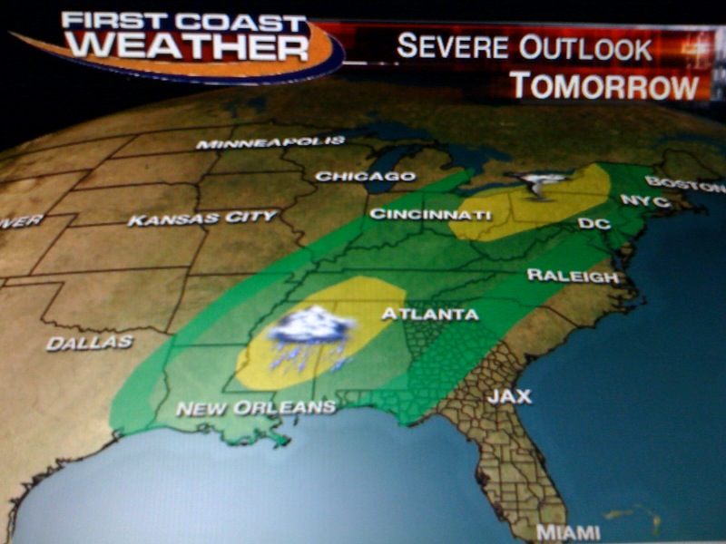
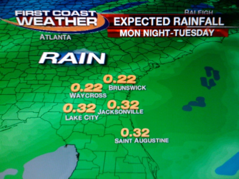
By time this line moves our way there should not be much left to it by time it arrives late Monday night and Tuesday. It is lacking deep moisture and all the dynamics quickly lift north. At least our rainfall map is still showing a free lawn watering with about a quarter-inch of rain. But, I still cannot promise that everybody will see rain as this front moves through in a weakened state.
So in this forecast today it is all about staying cool and smart in this short heat wave with plenty of pleasant temperatures on the way next week. I have highs in the 70s now for Tuesday through Thursday with more chances of needed rain by next weekend. Enjoy the rest of your weekend and thanks for reading. See you tonight at 6, 6:30, and 11 p.m. with a check on this historic weekend heat wave and more on the relief! So much to talk about and so little time. Thank goodness for this blog.
No comments:
Post a Comment