
April 17, 2011
Picture-perfect pelican weather is on the way today. Thanks to Tressa Keller for sharing this beautiful photo from St. Augustine. Today nicer weather will swoop in thanks to high pressure. It is the beaches grand opening parade day today and it looks great for all the floats and activities. It will be sunny with a nice light northeast sea breeze moving in. Highs will be in the middle 70s. Inland areas will be in the upper 70s to near 80. This is long overdue in a month that has brought an unprecedented 4 record highs. Not only will it be comfortable but the rip current risk will remain on the low side. Most folks do not realize that rip currents, heat waves, and flooding kill more people every year than lighting, hurricanes, and tornadoes. Just make sure you know that you can still have rip currents even on quiet days especially near piers, inlets, and jetties. Today you can enjoy a nice dip in the ocean after the parade with water temperatures now in the lower 70s. It will be a terrific boating day and a good day to go to the blessing of the fleet at the Jacksonville Landing at 2 p.m.. A northeast wind will be at 10-15 kts. and seas only 2 to 4 feet with a light inland chop. Yesterday it was brutal on land and at sea. We had folks having a tough time just getting in their boats with tropical storm force wind gusts of 41 to 48 mph rocking us and this occurred without any thunderstorms! There were a few trees down across the area including at the big Boat Show at Metro Park. Stephanie Bickers captured wind damage to trees and folks holding on during some of those vicious wind gusts.


We were very lucky even with a few damage reports around the area yesterday. The reason for the relentless wind was the result of what some meteorologists are now calling the Super Outbreak of the 21st Century. This is due to the sheer number of tornadoes over the past 3 days now estimated close to 230 from Oklahoma to Maryland. North Carolina had its most tornadoes since at least 1984 with dozens of fatalities. We stayed on the dry, windy and warm side of the storm and came within one degree of the record high of 90 set in 1972. This monster storm has now been replaced with high pressure that will settle in for the next couple days. This is perfect timing because we have the full moon tonight!

Tonight's may not be the biggest full moon in 18 years like we saw last month but it will be pretty darn close. Tonight's moon is only 941 miles farther away than last month's super moon. I do not think you will be able to tell the difference between this one and the super moon so I am calling it the spectacular moon! Yes it will still be much brighter and bigger than normal and one of our biggest moon's of the year since it is at perigee within 22 hours of being full. Look for a crystal clear moonrise at 7:48 p.m. and I do expect another brilliant red moonrise like Donna Deegan took for us with the Super Moon above. Our drought continues and without a lot of rain to cleanse the atmosphere there are plenty of particulates in the atmosphere to give the moon an extra colorful glow as its light is reflected and refracted many times over before reaching our eyes!
Speaking of the drought it looks like it will be once again catching up with us this week. As our main storm track stays north we stay mainly dry and look for temperatures to once again take off to near 90 degrees by the middle of the week. Some models are showing a wetter, cooler pattern developing next week but right now I think it is safe to say we may have to wait on thunderstorm and tropical season for our rain to really kick in. So keep on watering and I will keep you updated. The good news is that my long-range outlook for the summer has us closer to normal on rain and temperature thanks to a weakening La Nina and high pressure setting up in Texas. Check out the map below with plenty of hope for us! If you are in the Midwest it does look cooler and unsettled. Send us some of your rain please!
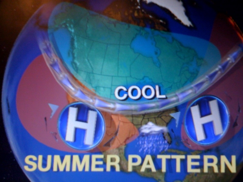
The only concern is the weakness in the atmosphere between the two high pressures will be an increased tropical threat to Florida this year. Tropical systems like to move around high pressure systems and the steering currents do not look very kind to us here in the Sunshine State. It looks like our high risk areas will be the Carolinas, South Florida and the Florida panhandle. This is the total opposite of last year when we had a blocking high pressure over us and it kept the tropical cone of concern over the southern Caribbean as went into drought conditions. It will be interesting to watch. Speaking of interesting, our weather blog question of the day was dealing with those unusual rainbows in the sky on Friday. Here is a picture sent in by Heather Patterson.

It is tough to make out the rainbow colors in this picture but it is a great shot of the halo around the sun that was visible. What folks were really seeing was not rainbows, but a phenomenon called ice halos. Rainbows are caused by sunlight refracting off the back side of rain drops. With halos the sun's light is actually being refracted off ice crystals creating the same prism effect, only the light is going through hexagonal ice crystals which causes the ice halo effect you see in this picture rather than the rainbow caused by rain that arcs across the sky. These high clouds were out ahead of the Super Outbreak that thankfully missed our area and today we will certainly all be counting our blessings. Have a wonderful day and thanks for reading. I look forward to checking in with you tomorrow to talk about the Lyrid meteor shower on the way this week. What a week ahead with a full moon and shooting stars! This is what it is all about.
No comments:
Post a Comment