
It wasn't even Friday, but that did not stop nature from making it one of the wildest days at WLFI since the Blizzard of 2007 hit. For the first time since the great ice storm of March 1991 we did not have a regularly scheduled newscast. That was when some areas had 2 to 3 inches of ice and ice chunks the size of automobiles were falling off our TV tower. Yesterday our building was hit with a lightning strike. It wasn't just a typical lightning strike. It hit the station at 2:11 p.m. after the severe thunderstorm already moved well to our east. The radar above shows the main part of the thunderstorm was about 7 miles away, yet we still got hit. How did this happen?
This was caused by a positive lightning strike. Meteorologists separate lightning bolts into two categories which are positive and negative. The positive strikes are 8to 10 times more powerful, last 10 times longer, and their voltage is much higher at usually more than 300 kiloamperes. These positive bolts are also most likely to fly out and travel great distances from the main thunderstorm. This is what we saw yesterday. The thunderstorm top grew to 50,000 feet or about 10 miles high in the sky. The higher the cloud the better chance for severe weather and for positive lightning strikes. These are the most dangerous type of lightning strikes as we saw yesterday.
This was caused by a positive lightning strike. Meteorologists separate lightning bolts into two categories which are positive and negative. The positive strikes are 8to 10 times more powerful, last 10 times longer, and their voltage is much higher at usually more than 300 kiloamperes. These positive bolts are also most likely to fly out and travel great distances from the main thunderstorm. This is what we saw yesterday. The thunderstorm top grew to 50,000 feet or about 10 miles high in the sky. The higher the cloud the better chance for severe weather and for positive lightning strikes. These are the most dangerous type of lightning strikes as we saw yesterday.
The story gets better. We even had a St. Elmos Fire effect before the lightning bolt hit. One of our satellite dishes looked like it lit up before the lightning bolt zapped it. The lightning bolt traveled from the dish to the edge of our building and it shook it. The return stroke apparently was so powerful it damaged several pieces of our equipment, including portions of our microwave tower. It is ironic this is severe weather awareness week and was a perfect example of why I always tell folks that most people are struck by lightning out ahead of the thunderstorms and after the thunderstorms move away. Yes, most people are struck by lightning when it is not even raining outside. Luckily nobody was hurt or injured. Our Precision weather computer wasn't so lucky. You can see how it flat-lined. The good news is we have it up and running in the weather center again and you should see it on the air in the near future.
 I wanted to give a shout-out to our resilient staff and engineers. They gave that word true meaning yesterday by moving our main control room you see in the picture below to our traveling trailer in only 4 hours time. Many television stations across the country have been knocked off the air for days when they take a lightning hit like we did. Great job guys. This shows you how resilient our station really is.
 Today we will have another chance of strong thunderstorms and we will have to watch things closely as we are still in the warm sector between the cold front to our west and warm front to the north. As the cold front moves closer it will add lift to the atmosphere and increase our chances of severe weather. I think our highest risk will be in the afternoon and evening and maybe one more round on Saturday before we clear out by late day. We will not only have to watch out for lightning, but damaging winds of 60 mph, and localized flooding.
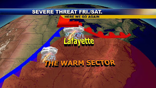 Weather Team 18 will keep you posted throughout the day. Talk to you soon. Here is the weather song of the day. See if you can guess it. I will talk more about this phenomena here on the blog in the near future.
23 comments:
Thanks again for the early morning update. I will check back all day, since we have many walkers involved in the Relay for Life tonight we are concerned about the timing of these storms.
Hey Brow...just checked out your website. Pretty neat! Great cloud pic, too!
Thanks for checking that out!
Good thing everyone is ok at WLFI headquarters.
I've got one eye open right now and drinking my get-me-going-good-morning-caffeinated beverage.
Still trying to get over that 10,000 BC movie hangover...what a disappointment!
Morning all everyone ready to track these storms? So far still no tornado reports thank goodness!
a lot of hail and high wind reports though.
Justin in Lafayette.
looks like some very strong storms are on the way! maybe by noon?
Justin what do you use to track the storms? I have a couple of weather maps I use but a good program would be better. William in Remington.
Justin I don't think this is a tornado event at all. Just wind more than likely. Could get a derecho.
I just use the maps on line as well as the weather radio and I have a weather forecaster. works for me :)
Justin in Lafayette.
Looks by my radar that strong cells are moving towards Benton, Newton, and Warren counties in the next hour or so maybe by noon. they are moving about 20 miles per hour....these storms contain very heavy rain and high winds, also a system is trying to work its way to Tipp co. The storms in Ill contained 100mph wind gusts
Mike maybe you could use this as you next song on the blog over the weekend! I can see clearly now, the rain is gone,
I can see all obstacles in my way
Gone are the dark clouds that had me blind
It’s gonna be a bright (bright), bright (bright)
Sun-Shiny day.
I think I can make it now, the pain is gone
All of the bad feelings have disappeared
Here is the rainbow I’ve been prayin?for
It’s gonna be a bright (bright), bright (bright)
Sun-Shiny day.
Look all around, there’s nothin?but blue skies
Look straight ahead, nothin?but blue skies
I can see clearly now, the rain is gone,
I can see all obstacles in my way
Gone are the dark clouds that had me blind
It’s gonna be a bright (bright), bright (bright)
Sun-Shiny day. Artist Johnny Nash
Hey Justin what does your radar show. looking darker out there
So far for lafayette some storms are starting to move in but the worst of the storms are tracking up to newton, jasper, and benton, co.
Justin in Lafayette.
From what I'm seeing on the radar, the storms don't seem as robust as they did earlier this morning - a good thing, as Martha would say ;-)
Dogmom Cheryl in Brookfield Heights
Justin is right, most of the nasty stuff is further north.
I would say in about another hour or 2, we should be getting wet.
I dont think it will be long before the rain moves in to Tipp, co. as a matter of fact just on the line. More storms from Iowa moving into Il these are moving fast! And full of hail
So far I think all lafayette has to worrie about with this system is going to be heavy rain. Now later is another story.
Justin in Lafayette.
Hey Justin, did you ever find a wind sensor?
Teri in Laf.
I have found some have not bought one yet but will soon I thank you for your help.
Justin in Lafayette.
Its raining softly, a warm muggy rain in Laf. The air is thick!
Teri
Pouring in Monticello.
By the time that I took the pic and uploaded it, it started raining.
Click my name to see the pic...nothing amazing, but fun to share. :)
http://www.webturd.com/monticello_clouds2.jpg
Brow my wife called from Remington and said the clouds were pretty cool looking. We have open fields around the house so you can see them coming for quite a distance. I think the wind farm in Benton county is absorbing most of the energy from these storms. That is where most of them have fallen apart. (G)
William in Remington
Watch box in Ill now. Can we expect a watch in our area later? Any ETA for the stronger storms yet?
ML
There is a cell in west I'LL, the clouds are at 600FT with hail now that system is a good ways away from us. will we be put into a severe thunderstorm watch later will just have to wait and see.
Justin in Lafayette.
Post a Comment