
Thursday, December 16, 2010 (12:30 p.m.)
It was a fun morning as usual and we even played fireworks sound effects during the 7 day forecast to celebrate not just the best weather of the week but the best weather of the month on the way. I know that is not saying much when temperatures are running 12.3 degrees below average. By Friday I think we could be almost 10 degrees above our average high of 66. Today with a southwest wind we could hit 70! Yes, that is where we should be for this time of year. Today at noon on the air I was certainly a proud Dad when I was talking about my daughter and how great the Fruit Cove Middle School chorus did out at the Landing this morning. My hats off to the music director Mr. Staffaroni. I am relieved the weather cooperated. First Coast Christian and Westview also sang and I wish I could have heard them. The good news is there will be many more holiday performances to enjoy:
Fri., 12/17
5:45 p.m. Fleming Island High School Step Club
6:15 p.m. TNT Dance Force
7:15 p.m. Dynamic Country Academy
8:15 p.m. Switzerland Dance School
Sat., 12/18
4 p.m. Nancy Dance Studio
5 p.m. Bravo Dance and Theater
6:15 pm. Jax Starz
7:15 p.m. Dynamic Dance
8:15 p.m. Switzerland Dance School
Sun., 12/19
4:15 p.m. Musical Theatre Troupe
5 p.m. Miss Duval, Miss St. Johns
6:15 p.m. Scott Jones Dancers
7:15p.m. The World of Dance
Thurs., 12/23
6:15 p.m. Dazzling Diamonds
7:15 p.m. Blake Dawson (ATrue Productions)
Now the question is will the weather continue to cooperate? I think it will and here is why!

The Pacific express is now in charge and will help warm us up into the 70s Friday and even Saturday I think we can hit 70. This is a huge pattern change from the polar express that took over our pattern and has brought as an infamous December chill here in Florida many will not soon forget. The flow is now coming off the warmer Pacific Ocean as opposed to it coming right down from the polar bears nesting grounds. As we finish out the rest of this year I do not see any bitter cold outbreaks like we have seen. Not anything close. Yes we could see a light freeze Christmas Week but that will seem like a walk in the park. The blocking pattern in Greenland is now changing and the coldest of the weather is shifting from the eastern and central United States back up toward the Arctic Circle and Alaska where it belongs. The other batch of really cold weather will start to center on Asia and Siberia. While Europe will have below average temperatures I do not see them setting 200 year records like they have been. So here at home there is plenty of good news. Bottom line here at home is we will look back on this the worst of winter's cold taking place before winter even takes place. I do not think we will hit 20 or lower again until maybe next autumn or winter! Check out the latest weather notes.
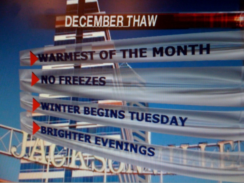
I am just going to keep the good news coming. See I am not all doom and gloom and love talking about good news. Let me brighten your day up more. Well nature will be doing so as well! We have now gained two minutes of daylight in the evening. Yes, I know the shortest day of the year is on Tuesday or the first day of winter which officially begins at 6:38 p.m. But what most do not realize is that with the earth's elliptical orbit that we start gaining daylight in the evening before the shortest day arrives. Keep in mind the mornings will still be getting darker but really not by much. The sunset tonight is at 5:28 p.m. compared to 5:30 p.m. on December 21st. The sunrise today was 7:16 a.m. and will be 7:19 a.m. on December 21st so there is only a net loss of one minute. Yes, the darkest and coldest days are really behind us!

Want more good news! Okay you need to leave work early Friday because we have a cold front that will come later rather than sooner. I think with drier weather most of us can pop up in the lower to middle 70s. Most of your rain will stay from Alma northward and it should be light and scattered. If you look to the left of your screen you see an area of low pressure. This will actually track along the front Saturday and act to slow it down. This means we have a better chance of lift and more widespread rain. Areas to the north of the front will have the heavier amounts will areas south would have less but should still see some rain. Stay tuned to Chief Meteorologist tonight and of course I will be back first thing in the morning with your most up to date models and local forecast! Now it is time to get out in the sunshine! Enjoy.
No comments:
Post a Comment