Sunday, December 5, 2010 (7:30 a.m.)
Blog Archive dating back to 2007 http://lotsofbarkandbiteinyourforecast.blogspot.com/
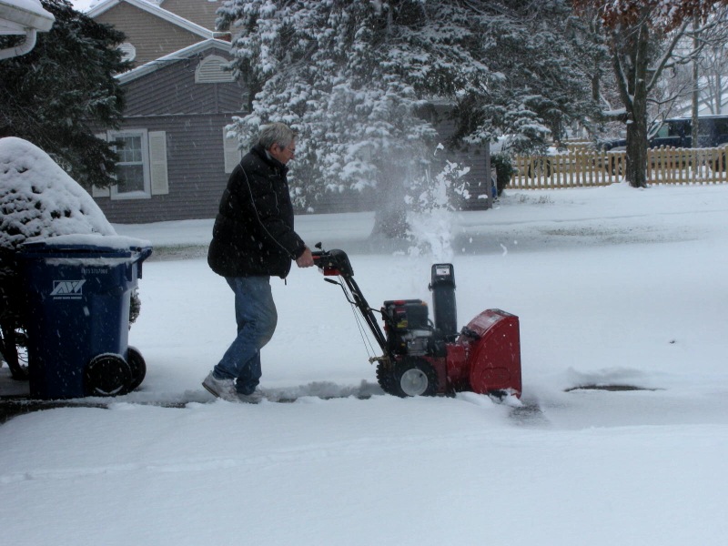
Well I showed the warning signs of a big polar plunge yesterday on First Coast News. Mary Anne from Remington, Indiana was kind enough to send us a picture to reinforce the forecast that we will have to get ready for the coldest weather since last January here at home. The snow blowers were going strong after 3.4 inches of snow fell. The tornado sirens were blaring not due to severe weather for once (Indiana has its own secondary tornado alley you may not know about. Indiana has just as many tornadoes per square foot per year as Oklahoma) but to herald Santa's arrival. Mary Anne and I have tracked several tornadoes together through the years and she has become like family. Yes, nature's power may be devastating at times but it can also bring folks together and create life-long bonds that I am grateful for. That is what following weather is all about! Santa certainly was a happy camper as he flew right in with the jet stream and it was a quick easy trip. Right now about 40% of the country is covered in snow and when you combine that with a cross-polar flow or jet stream coming straight down from the Arctic or Santa's workshop you have what is called a polar plunge or the polar express. We at least had our weather pick of the week live up to its name on Saturday with splendid sunshine and highs of 71 in Jacksonville to 74 in Palatka. Many folks finished hanging their decorations just in the nick of time.

Today is a different season altogether. Spring fever is gone and we will hold steady in the middle to upper 50s. The arctic front came through early this morning with a few sprinkles. The pictures above may be beautiful but this snow cover actually allows the cold air coming down from the North Pole to hold together much longer and keep it stronger on its journey into our backyards. Teri in Lafayette sent another great picture of the pattern gripping the country. There is freezing weather gripping more than half the country and this winter wonderland will help bring us our coldest weather since last January 11th when we dropped to a bone-chilling 20 degrees here in Jacksonville. Berry nice Teri! Is it okay if I send the cold weather complaints your way? After all we would not be in this predicament without all your snow....lol...But seriously I do love the contrast between the fresh white snow and red berries. Keep the great pictures coming and yes I am thankful for you and all the storms we have tracked over the years.

So there you have it. We have all the ingredients which includes a polar jet stream, snow cover, and we do not want to forget the blocking pattern taking place in Greenland due to the negative NAO which we talked about here on the blog. You see the blocking high over Greenland redirecting the jet stream much farther south than normal. It also shows where this cold air is coming from. Notice the source region in the Arctic Circle where the mercury is currently freezing due to temperatures of -40. Also in Greenland it is unusually warm with current temperatures in the 40s above zero this morning. Nature is certainly sending us all the cold air that really should be up in Greenland and much farther north. If someone is much warmer than normal then nature keeps a balance and we are the ones that have to be much below normal. Amazingly, we will actually be colder than parts of Greenland by Monday morning. One other thing to note is that there will be wind with this polar blast. Yes it is nature's one-two punch! Here are some of the latest numbers, ready or not!

We already have freeze warnings for tonight but we also may have wind chill advisories issued. By morning wind chills will be near 20 in Jacksonville and by Tuesday moring it will feel like a nose numbing 14 in Waycross. The actual first freeze at most area beaches will be on Tuesday morning along with a hard freeze inland. This means we remember the 3 P's. Protect the pets, plants, and pipes. Here are actual lows expected on Tuesday without the wind chill.

Whenever St. Augustine has a low of 30 degrees we know this cold air is a huge deal. Melbourne could also have a freeze and by Wednesday Tampa will likely join the Freezing Club. Waycross shows a low of 22 on this graphic, but I may be leaning upper teens based on some of the latest information. Here are few more weather notes to help prepare you.

Record cold is on the way Wednesday and Thursday mornings with a hard freeze watch becoming a warning for Tuesday through Thursday mornings. Watch for wind chill advisories to go along with our freeze warnings. When will we thaw out? Here is your answer in the 7 day forecast. Yes, the good news is it will feel much better by Friday afternoon. You stay warm and we will watch the thermometer fall together on and off the air. I will certainly have to bring my anchors some hot chocolate for tonight's shows. It is the least I can do. Go Jags and with a great day to watch football with due to our chilly forecast do not be surprised if you see a few snowflakes during the Jags-Titans game today. Since the Jags played well in cold New York last week I think they will be just fine in that 37 degree weather!

No comments:
Post a Comment