
Friday, December 10, 2010 (3 p.m.)
Archive of Weather Blog back to 2007 http://lotsofbarkandbiteinyourforecast.blogspot.com/
Friday was a classic day of what an inverted trough can do to a forecast here on the First Coast. Chief Meteorologist Tim Deegan did a great job pointing this out last night on his weather shows. The guy is simply amazing and his 25 plus years of experience here on the First Coast paid its dividends today. I am like a sponge around Tim learning all I can. He is a wealth of knowledge. Those inverted troughs many times cannot be picked up by our weather models very well. Today was a classic example of that and it was what caused what should have and could have been a sunny and nice forecast to dark and gray. The inverted trough had plenty of clouds with it and it held temperatures down in the middle 50s. Our middle 60s we could have reached were out in Tallahassee where they were enjoying all the sunshine today. Yes, this change in our weather is a local phenomenon. Just think of it as a home-brewed low pressure that sometimes forms right here in our backyard. It was caused by temperature differences between the ocean and that cold polar air mass that has overtaken our world this week. Check out this striking map of water temperatures this week of our Florida coastline.

While temperatures were in the upper 20s this morning in Waycross the Gulf Stream about 80 miles offshore still had water temperatures near 80. You add in a little upper-level vorticity or weather disturbance and voila a new low pressure is born. Most of the models did show a low pressure forming today but it was supposed to be much weaker and farther offshore. The good news is this pesky low pressure is going to move northward toward the Carolinas tonight and in its wake we will have the best weather of the week on Saturday. I do not expect any more surprises. Just be wary of a little patchy drizzle and fog from this system mainly east of the river as we had through tonight. The clouds should break up during our Saturday morning.
Now there was also a chill in the air and at times it did look like it would snow outside and with that chilly breeze it felt like it too. There were reports around town of snowflakes over the Buckman Bridge and at the St. Johns Town Center. Did it really snow? Well here is what I found. After speaking to those that that really and sincerely thought they saw snow I double-checked everything just in case. Since I am a SNOW FREAK by nature if there was anybody able to verify snow in the area it would be me. I went over all the radar data that shows precipitation type and it came back negative. Then you have to check temperatures from the ground to about 5,000 feet or higher and it confirmed that snow would not be possible meteorologically. Air temperatures were in the 50s by noon today. Also I checked the 5,000 foot temperatures. To have snow you need temperatures at 5,000 feet close to 27 degrees. Today temperatures were a whopping 18 degrees warmer or 45 degrees even first thing this morning. So based on science I just do not see how it could have snowed. But one theory I did have is you may have seen ash falling from the sky. Here in northeast Florida there are now 20 wildfires going including a new 14 acre fire in Welaka down in Putnam County. Check out this amazing picture shown on First Coast News at Noon.

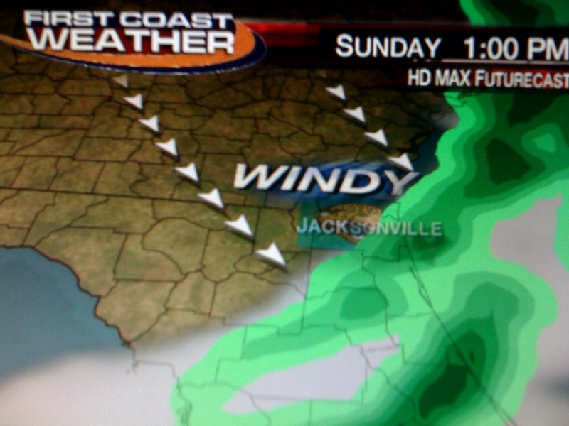
The good news is we do have at least some rain to help dampen up some of that dried out brush causing those wildfires. The latest models are not showing very much rain but we will take every little bit we can in one of our top 5 driest years on record. I think most of us will see a quarter inch or less. If you are in Waycross or Lake City maybe a little bit more. Since timing is everything I do think it is on our side for the big Jaguar game. The back edge of the main line of rain showers should move south of Everbank Field in time for kickoff. Yes, rain will fly in sooner rather than later as the main front rides in on a 130 mph jet stream! Here is the latest future cast that shows the back edge of rain heading into St. Johns County by 1 p.m. so the Jags can take care of business.
So yes you will need the ponchos for "TEALGATING" and the warm winter coats for the main game. Great job Jags fans because for the 7th consecutive home game there will be NO blackout. The support for our Jags has been outstanding this year and we will not let a little rain or wind that moves in during the game keep us from filling the stadium. Besides our running game and all our cheering should make those 20 to 30 mph west-northwest wind gusts a non-factor. Actual temperatures will fall through the 50s during the game. I will keep you updated on this forecast because the main front is still way back in Texas. In the meantime, have a great weekend. Here in Florida we are the lucky ones once again. One to two feet of snow could fall in the Twin Cities and wind chills of 40 below zero are on the way to Duluth. In Lafayette, Indiana you still have at least 2 to 4 inches on the way and there will be so much wind you might as well prepare for it like you would for a foot of snow. Travel will be tough at best. We will track polar outbreak number 3 together this weekend because by Monday morning we could have wind chill advisories here at home. I will keep you updated on our potpourri of weather on the way. Take care and have a great weekend!
Remember to download our free weather app at FCN Wx. You can track our 10 day forecast updated by your weather team at least once per day and it has street-level mapping that will come in handy on Sunday!
No comments:
Post a Comment