
Sunday, June 26, 2011
Technically lightning alley runs from Tampa to Titusville where about 100 thunderstorm days per year. Here in Jacksonville we see our fair share of lightning with an average of about 70 thunderstorms per year. Florida is the lightning capital of the the US. We have a ton of heat, moisture and lift to work with thanks to being on a peninsula, our latitude and the collision of two seabreezes that take place. Today we live up to that reputation with more collisions at the surface and at 40,000 feet between ice crystals. Look for more electrically charged clouds to move our way. The blog question of the day is which country averages the most thunderstorm days per year. Take a look at the NASA map above. Impressive! The title has to go to Rwanda in Africa that has an incredible 300 days per year with thunderstorms. Kifuka, Congo has the most lightning strikes per square kilometer per year. Columbia and Venezuela are next on the list followed by Pakistan and then Florida. So really we are sixth in the world in lightning. The place with the least amount of lightning is the Arctic Ocean and Antarctica but their atmosphere is charged up with the aurora.

Today get ready for more cumulonimbus clouds. A special thanks to Larry who captured this scene at St. Simons Island on Saturday evening before about 1,500 lightning strikes moved through the area. There was also a 60 mph wind gust reported on Jekyll island. The big news was a good portion of Camden County had a one to two inches of drenching of rain as outflow boundaries to the north helped to trigger thunderstorms. Farther south there were reports of one to two inch rains in Putnam Country through northern Flagler County which included areas over the Espanola Fire! So while many areas to the north missed out on rain at least it is falling where we need it most. Here is yesterday's rainfall map.

The areas that were missed yesterday in a strip through portions of southern Bradford, Clay, and the heart of St. Johns County will likely see better chances of heavier rain today. Notice our latest Future Cast model. It shows the heaviest rain today south of Interstate 10 with mainly late day and evening storms which could once again prompt a few warnings for gusty wind and hail. A drier slug of air is moving into Georgia but we cannot rule out an evening storm that could be strong especially up near Waycross.

It eventually all evens out! It really does and the hit and miss nature of our rain is normal. The good news is even though we had a lot of lightning last night with storms they are not igniting as many new wildfires as before. Remember we were seeing about a dozen new wildfires per hour during the worst part of this fire season about 2 weeks ago. Now we are seeing just a handful of new fires that have broken out this weekend according to the Division of Forestry that are small and quickly contained. This is because our soil now has more moisture to work with. The latest KBDI index which measure soil moisture no longer has desert pink over us like I showed you on the blog last week. Check out the much better news!
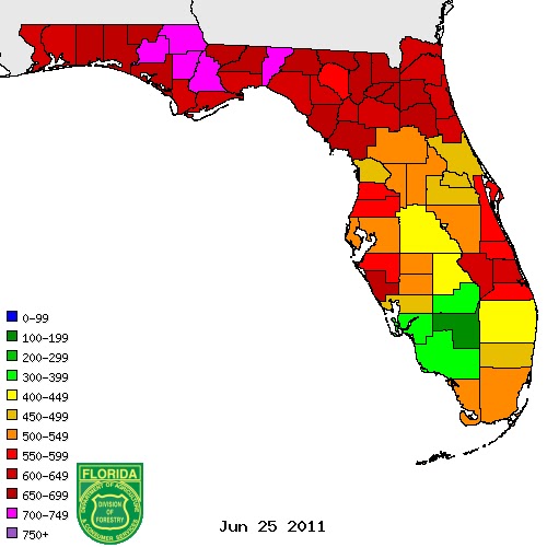
The scale runs from 0 to 800 based on the top layers of the soil moisture and really anything in pink is desert dry. The red areas are still critical and that is why this forecast is so important. Due to the high evaporation rates, if we only go 3 days of having dry weather the situation could once again ramp out of control with the wildfires once again. The good news is the drought-inducing high pressure will continue to park over Texas this coming up week allowing our sea breeze collisions to take place. There will also be a few disturbance dropping our way along with another frontal boundary by late week. So we have a lot of positives! Every single day there will be storms to track on Live Doppler Radar, especially in the afternoon. Let's keep it coming. It is already made a big difference! It sure is nice to see those blue skies again over Mandarin thanks to all the rain we have had! Here is a nice shot sent to us from Mike Lyons this morning.

You have a wonderful day and make sure to have your First Coast News weather app handy again today! It has your two minute advantage and I do several video updates on there to keep you ahead of the storm. Be safe and do not get complacent with the lightning. More folks are killed in Florida by lightning than any other weather phenomenon. While it is nice we are getting the needed rain the dangerous lightning and strong storms here in Florida also come with it. They don't call us the lightning capital of the US for nothing.
No comments:
Post a Comment