
Tuesday, June 7, 2011
Rain clouds! I had to take a picture because it has been so long since I have seen nimbostratus clouds. Yes, most of us did see rain on Monday afternoon. I was enjoying my conversations about the rain with folks at the grocery store. Everybody was so excited! But not everybody was dancing in the rain, Fleming Island did not have enough rain to even wet the sidewalk. This is typical in Florida come June and this is why our weather team could not promise everybody rain. You just do not have large scale weather systems that can hold together this time of year as the jet stream lifts up to the Canadian border. We go from having widespread rain to convective rain this time of year which means getting that free lawn watering is dependent on heat thermals that can weaken just as fast they form especially if you get under a thunderstorm's cooler cloud canopy. This is exactly what happened in portions of Clay, St. Johns, Flagler and Putnam Counties where the smoke and wildfires have been the worst. We also see this many times ahead of the Gulf Coast sea breeze where storms are rolling east and the rain quickly falls apart before it reaches Jacksonville due to upper-level winds pushing the cirrus clouds over our area stabilizing the atmosphere. But yesterday the rain hitting most of us was the big story and here are the rainfall amounts I have waited all so long to post!
I-295, I-10 West Side 1.55"
Ortega 1.33"
Downtown Jax 1.20"
Hilliard 1.07"
Jax NAS 0.98"
Folkston 0.57"
Mandarin 0.29"
Keystone Heights 0.20"
Macclenny 0.10"
Arlington 0.09"
Jax Beach 0.04"
Jax Int'l 0.02"
Mayport 0.01"
St. Johns/Julington 0.01"
St. Augustine 0.00"
Palm Coast 0.00"
Unfortunately I do not see any big widespread rain chances for the rest of this week. The rain will be more hit than miss. The long-range models are trying to paint a rosier picture with an increase in rain and storms next week but they have been doing this for the last couple weeks. I hope this time they are right. It does look like we will be between two high pressure systems which would give us a much more tropical flow helping increase our shower and thunderstorm chances. Here is the 18,000 foot charts on Sunday.
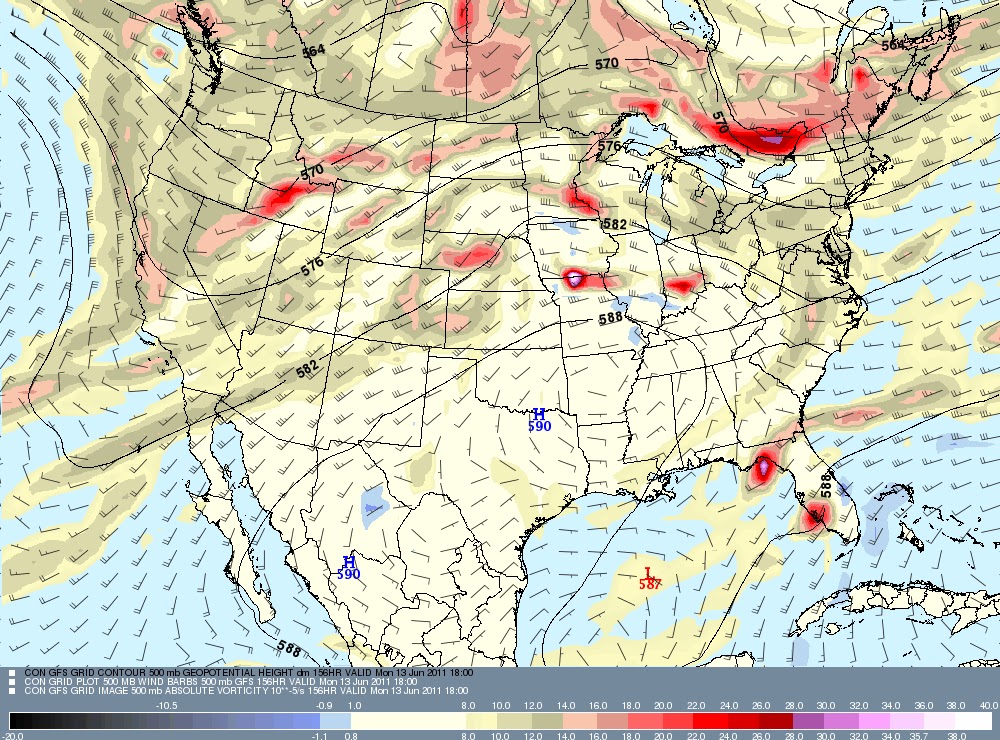
Notice the red areas popping up across Florida. These are areas of spinning rising air and would be moving toward Jacksonville with deeper moisture and plenty of heating to work with. So I do look forward to increasing rain chances especially next week here at home. The good news for us is that the worst of the heat and the suffocating high pressure that has brought us a smoky, scorching atmosphere is not showing up anywhere close to home anytime soon. This is a sign of a shift in the pattern trying to take hold. We will take every little sign for a rainier pattern and run with it at this point. Highs should be closer to 90 than 100 which will be a nice change with areas east of Interstate 95 likely remaining in the 80s for the next few days! Yes, we can breathe a sigh of relief in more than one way. Here is the latest Air Quality Map.

Areas of yellow and orange which can cause problems for those with respiratory ailments have been pushed west of Macclenny, although it will still be smoky for area of western Clay and Putnam Counties westward and for those living in interior southeast Georgia including Waycross. This trend of the thickest smoke remaining west of the river should continue for the next several days. What we really need is several inches of a soaking rain like we saw here in early June of 1968. I know a lot of my neighbors have been wishing for rain from a tropical system and even though none of us want a hurricane or tropical storm to strike here at home I do agree we can certainly use some moisture from a tropical system. Take a look at these rain amounts from Tropical Storm Abby back in 1968!


Yes, there is an impressive swirl in the Pacific. This is the first tropical depression of the year that has formed in the East Pacific off Mexico and it it over water in the middle 80s with low wind shear. So no Arlene, but expect Hurricane Adrian by Thursday and it could reach category 2 status before it drifts northwest and weakens over cooler waters this weekend off Mexico. Last but not least in our unusual blog weather story of the day and yes there is plenty of unusual weather around the globe to pick from here is my top pick! Check it out!
Yes, they are skiing in Hawaii! Keep in mind it is not all that unusual for skiing to take place in Hawaii on Mauna Kea which is above 13,000 feet but what is unsual about this is it happened in June. Another weird fact of the day is that Minneapolis and Chicago will be about 5 to 10 degrees warmer than us here in Florida with excessive heat warnings. Yes, we should not be complaining about the weather, it could always be worse. Have a great day and keep that glass half full.
No comments:
Post a Comment