
We were long overdue for severe weather here in Lafayette and nature made up for some lost time. You see the ominous wall cloud picture above that were captured by Eric Graham near Otterbein. It was part of a supercell thunderstorm we tracked on Live Doppler 18 all the way in from near Champaign, Illinois. This supercell would play havoc with our weather here at home over the next four hours. It would touch down two tornadoes, down hundreds of trees, pound some of us with a month's worth of rain in only two hours and pummel us with quarter size hail. Numerous roads were blocked with trees, especially in the Battle Ground area and even along state road 25. Other roads and fields were turned into rivers. Those roads included state road 18 in Benton County and state road 43 in White County.
The video below really tells the story. Here is some video taken by Jim Leonard near Cambridge Estates off of state road 38. Jim was shooting north toward Battle Ground when that area was being hit with vicious wind gusts estimated at 70 to 90 mph.
If you look to the right hand side of the video as it plays it looks like there was a microburst or a rain-cooled area of dense air that helped push those high upper-level winds to the ground. This would explain why Battle Ground had so many reports of downed trees and actually looked like a battle zone after this storm moved through. Residents were told to stay in their homes due to huge areas of debris blocking roads and if that wasn't enough, 2 to 3 inches of rain flooded the roads that were not blocked with debris. It reminded us all of when Dayton was shut down after the tornadoes moved through that town back in 2004. In this case though we did not have any tornado reports, but most likely it was caused by straight-line winds. This is a good example of how straight-line winds can cause just as much damage as a tornado sometimes here in Indiana. Here are some more pictures of the incredible supercell as it moved across our area.

Audrey Hardebeck shows what torrential rains can do. She reported 4.5 inches of rain just north of Fowler. Mary Anne in Remington said it reminded her of January 2008 as she recorded 3 inches of rain. Kentland had 2.72 inches of rain while Bruce Baldwin in Burlington recorded 1.8", but at one point the rain was coming down at a rate of 5 inches per hour. It is a good thing that heavy burst only lasted 10 minutes. More pictures being inserted between now and 3:30 a.m. Do not go away just yet!


Thanks Donna, I am glad you are safe and sound!
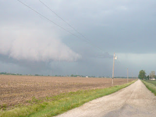
Laura Bisner shows this wall cloud traveled right along US 52 as this was taken in the Montmorenci area. It is almost as if this supercell had eyes and followed the main highways right into town AND DID IT LOOK NASTY IN LAFAYETE.

Brad Busse shows a picture that makes it look like the sky is falling. Why folks are in their cars and heading West right into the storm. I will never know. Is that my wife in one of those cars? It would not surprise me. :)
 Richard Beedle sent in another picture from the corner of State Road 26 and Creasy Lane. One interesting note is that he may have caught a funnel cloud trying to develop right along the wall cloud. If it was rotating it may have been the first picture of a funnel I have seen so far. Take a look at the possible funnel below.

I will let our long-time friend and blogger that now goes to Ball State describe what he saw in southern Carroll County when he was storm chasing.

Last but not least, I wanted to thank you so much for being our weather team's eyes and ears with all your great pictures and e-mails. I cannot say enough about our bloggers. You did a super job! A Julie update: My wife is safe and I knew we were in trouble when I not only saw the sunshine this morning, but found out she was going shopping. She told me she was evacuated to a shoe storage area at the mall so she was in heaven. Whenever my wife is at the mall during severe thunderstorms the chances of having tornadoes in our viewing area must be something like 80%. It never fails. I will warn you again next time she goes shopping on a busy weather day. My daughter Abbey called from Grandma's in Wisconsin during the severe weather. She was crying and worried about everybody at home but quickly gathered herself and is now doing just fine. We all know how sensitive she is about the weather and she is glad everybody is safe and heeded the warnings and most of all got inside when the tornado sirens went off.
This day reminded me a lot of Memorial Day 2004 when we had 4 tornadoes in Tippecanoe County and an amazing 12 tornadoes in our viewing area in one day. Yesterday, we had at least 3 super cells move through the area. In all on Friday we had 3 confirmed tornadoes with two of those tornadoes reported near Pyrmont or just north of Ockley in Carroll County and another tornado in Cates in extreme southern Fountain County. June looks to bring warmer weather and this year it will likely bring most of our severe weather so this was only a tune-up. We will continue to work as a team and in turn hopefully keep everybody safe. You have the all clear this weekend. Have a wonderful one and I will post more storm notes and pictures as they come in. God bless you and Indiana!
15 comments:
WOW!!! Great pix of the clouds!
We ended up with 3.20 inches rain and flooding. Not quite as bad as January 8th but for sure, a mess.
Mary Anne in Remington
Here in lafayette we had 1.25 inches of rain Im just glad we did not see any of thoughs clouds in thoughs pictures. Happy everyone is safe and mike tell your wife not to go shoe shopping anymore!!!
LOL.
Justin in Lafayette.
WHEW!
What a rough night. My family and I ended up going over to my neighbors house and hanging out in their basement while everything blew over.
I knew that we had it coming and we are all so thankful that we are up to see the sunshine today.
Hope everyone else out there is safe.
Thank you for staying on the air for so long & keeping us inform. I find the weather to be so much more entertaining than anything else they can put on tv.
I never realize the extent of the wall cloud I saw till I read about it this morning. Not only did I see it from work, but I am sure if I was back at my apartment I would have seen it there too! Thanks everyone for the pictures!
-Pam in WL
Was wild ride for a while, I did see those clouds develope, we took pics, and emiled them to Mike, they look just like the ones he posted, wonderful pics! My friend lives out near WLFI and told me it was amazing out that way, He just stated to me that Lindburg Rd. was closed on one area. Count our blessings that we just had fallen trees and power outages, could have lost lives!
Good morning again! I want to report Wadena in Benton County had 4.60 inches rain.
Anyone who has storm pics, please email them to ma_best@comcast.net
I am the weather watcher from Remington and am very much into weather! Ask Mike, LOL!
Thanks Mike for a great job last night!
Mary Anne in Remington
We were at the ymca swimming and had to go down to the basement, they did good over there getting everyone taking care of and giving us towels lol.
I got ahold of my mom and her bf who said they see a tornado.They live in Radnor,north of Ockely.The cat was freaking out and my mom was told to go to the basment. She said the clouds were going in all directions and he said he could tell what was going on bc shortly after they spotted the raid came down so bad he couldnt see across the yard.
They are fine now.
I am just glad that this weather happened when our kids were out of school, I do know the schools have a wonderful safty plan in force however it does not prevent a parent from worring. I realize that it was later in the day when the storms hit, still the threat stays with a parent. Sounds like the YMCA had their safty plan in order what about our local out door swimming pools, where would our kids go for safty? Before we could get to them?
To Bull/Bear, no one was trying to "steal your name" in last nigts blot, it was a typo error I posted welcoming you to the blog, but I posted Bull/Bull,so I corrected myself.
Just for fun did you know as you tucked Mrs Bear into bed, you stated you would call her that because "Mrs Bull would mean cow" A FEMALE BEAR IS CALLED A SOW!!! Just an FYI. Be careful!!!!!
Also a male bear is called a boar!
Love the study of bears, our polars are endangered, along with others, this post means no insult to you. Please dont be offended!
I guess it's a no win for Mrs Bull/Bear...
Re: Welcoming Bull/Bear: not really sure why anyone would claim to be me anyway...
To Bull/Bear: you really had people going on the blog,it was fun, we were all concerned. And as far as my comment about what a female bear is called. I do know that female Bears are very protective of their cubs, sounds like you had a great safty plan for yours in place during our storms. Look foward to future blogs, sounds like Mon/Tues, we could be in for more rain and possiable storms, What do you think?
Weather radio just sounded off looks like on the radar we have pop up storms to watch out for the thunder stomr watch was for south tipp.
Justin in Lafayette.
Those were great photos..We just got too much tornado this year around..This kind of severe weather are just so destructive and fatal..we just need to hang on for now..Hope everyone will be safe..
Justin
Ya we were at the waterpark yesterday and heard the warning on the radio and I was thinking NO!! At the top of the big slide you could see real dark clouds, but I wathced the direction and guessed that it would miss us. Looked close but it did so we got to finish swimming and had a great time.
Post a Comment