Saturday, May 31, 2008

3 Tornadoes & 90 mph Wind Gusts Ravage the Lafayette Area


We were long overdue for severe weather here in Lafayette and nature made up for some lost time. You see the ominous wall cloud picture above that were captured by Eric Graham near Otterbein. It was part of a supercell thunderstorm we tracked on Live Doppler 18 all the way in from near Champaign, Illinois. This supercell would play havoc with our weather here at home over the next four hours. It would touch down two tornadoes, down hundreds of trees, pound some of us with a month's worth of rain in only two hours and pummel us with quarter size hail. Numerous roads were blocked with trees, especially in the Battle Ground area and even along state road 25. Other roads and fields were turned into rivers. Those roads included state road 18 in Benton County and state road 43 in White County.

The video below really tells the story. Here is some video taken by Jim Leonard near Cambridge Estates off of state road 38. Jim was shooting north toward Battle Ground when that area was being hit with vicious wind gusts estimated at 70 to 90 mph.


If you look to the right hand side of the video as it plays it looks like there was a microburst or a rain-cooled area of dense air that helped push those high upper-level winds to the ground. This would explain why Battle Ground had so many reports of downed trees and actually looked like a battle zone after this storm moved through. Residents were told to stay in their homes due to huge areas of debris blocking roads and if that wasn't enough, 2 to 3 inches of rain flooded the roads that were not blocked with debris. It reminded us all of when Dayton was shut down after the tornadoes moved through that town back in 2004. In this case though we did not have any tornado reports, but most likely it was caused by straight-line winds. This is a good example of how straight-line winds can cause just as much damage as a tornado sometimes here in Indiana. Here are some more pictures of the incredible supercell as it moved across our area.


Audrey Hardebeck shows what torrential rains can do. She reported 4.5 inches of rain just north of Fowler. Mary Anne in Remington said it reminded her of January 2008 as she recorded 3 inches of rain. Kentland had 2.72 inches of rain while Bruce Baldwin in Burlington recorded 1.8", but at one point the rain was coming down at a rate of 5 inches per hour. It is a good thing that heavy burst only lasted 10 minutes. More pictures being inserted between now and 3:30 a.m. Do not go away just yet!

Here is another picture of the wall cloud in the Battle Ground and Buck Creek areas taken by Dustin Washington.

Here is a picture of that wall cloud nice and up close. This is what it looked like over WLFI TV-18 here in West Lafayette just after 7 p.m. We had clouds moving east over our station while the clouds over the Sagamore Park were moving in the total opposite direction toward the West. Storm chasers and spotters that saw this incredible cloud were in awe as it took up a good two-thirds of the sky. Some chasers remarked at how they have never quite seen a wall cloud that big. The good news is this rotation did not touch down on Yeager Road and I did not have to bring you the weather from the Boiler Room. But I would have gotten to my safe location if this cloud started coming toward the ground. I had my running shoes on and was ready to move everybody out of harm's way and broadcast the latest from there.

My name is Donna Raub and I took these pictures just before, and immediately after the sirens went off on Klondike Road, south of US 52. This was a huge wall cloud as you can see in the beginning. Then I noticed a sudden shift in movement from originally moving west to east, to suddenly appearing to rise up from in back of the trees along US 52 and move from north to south/southeast (as the latter pictures hopefully show). That was when the definete rotation started in two separate places in this huge cloud mass. That was also when I decided to take cover with my pets. My apartment is located right next door to the new Wabash Township fire station. They were having a meeting so there were numerous people there, and they may have seen the rotation also.

Thanks Donna, I am glad you are safe and sound!


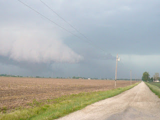
Laura Bisner shows this wall cloud traveled right along US 52 as this was taken in the Montmorenci area. It is almost as if this supercell had eyes and followed the main highways right into town AND DID IT LOOK NASTY IN LAFAYETE.


Brad Busse shows a picture that makes it look like the sky is falling. Why folks are in their cars and heading West right into the storm. I will never know. Is that my wife in one of those cars? It would not surprise me. :)

Richard Beedle sent in another picture from the corner of State Road 26 and Creasy Lane. One interesting note is that he may have caught a funnel cloud trying to develop right along the wall cloud. If it was rotating it may have been the first picture of a funnel I have seen so far. Take a look at the possible funnel below.


This may have been the first sign of trouble for areas of Carroll County. Here was a picture taken in Pyrmont one week ago. It was a beautiful sunrise. Little did residents know that one week later there would be not one but two tornadoes that touched down in their backyards.


I will let our long-time friend and blogger that now goes to Ball State describe what he saw in southern Carroll County when he was storm chasing.


Hey Mike,

Doyle McIntosh here.I was chasing in west central Indiana today and a friend and I are the ones that got the tornado in Western Carrol county. the tornado's were brief at best, but still a tornado. In all i think we counted 4 or 5 spin-ups each only lasting about 15-20 seconds, storm motions were some of the best id seen in a long time. Ive got some grainy video and pictures that I will upload tonight and send off tomorrow. contrast today was terrible but features were still discernible. FINALLY SOME SEVERE WEATHER FOR INDIANA!!

Doyle McIntosh

Here is what it looked like on Precision 18 in southern Carroll County when the tornadoes hit. You can also see the second supercell that would deliver a devastation blow and our third tornado of the night in Cates in southern Fountain County.

You have a great future ahead of you in the field of meteorology Doyle. I would go storm-chasing with you any day. Our Lafayette viewers and bloggers cannot wait to see your video. We will hopefully share it here on exclusively on the air here at WLFI TV-18!

Last but not least, I wanted to thank you so much for being our weather team's eyes and ears with all your great pictures and e-mails. I cannot say enough about our bloggers. You did a super job! A Julie update: My wife is safe and I knew we were in trouble when I not only saw the sunshine this morning, but found out she was going shopping. She told me she was evacuated to a shoe storage area at the mall so she was in heaven. Whenever my wife is at the mall during severe thunderstorms the chances of having tornadoes in our viewing area must be something like 80%. It never fails. I will warn you again next time she goes shopping on a busy weather day. My daughter Abbey called from Grandma's in Wisconsin during the severe weather. She was crying and worried about everybody at home but quickly gathered herself and is now doing just fine. We all know how sensitive she is about the weather and she is glad everybody is safe and heeded the warnings and most of all got inside when the tornado sirens went off.

This day reminded me a lot of Memorial Day 2004 when we had 4 tornadoes in Tippecanoe County and an amazing 12 tornadoes in our viewing area in one day. Yesterday, we had at least 3 super cells move through the area. In all on Friday we had 3 confirmed tornadoes with two of those tornadoes reported near Pyrmont or just north of Ockley in Carroll County and another tornado in Cates in extreme southern Fountain County. June looks to bring warmer weather and this year it will likely bring most of our severe weather so this was only a tune-up. We will continue to work as a team and in turn hopefully keep everybody safe. You have the all clear this weekend. Have a wonderful one and I will post more storm notes and pictures as they come in. God bless you and Indiana!

Friday, May 30, 2008

Prangley's Precast: Keeping Your Family Safe


I am concerned about a supercell thunderstorm moving into our viewing area after 5 p.m. You can also head to weather on demand in the weather section for more safety tips. Stay safe.

Conference Call Confirms Concerns

Just got off the conference call. No surprises. The National Weather Service has the timing on thunderstorms mainly between 9 p.m. in Lafayette to 3 a.m. in Richmond, Indiana. Areas in Newton, Jasper, and Benton Counties can expect storms to move in a little sooner.

Main threats: Wind gusts of 60 to 70 mph and the likelihood of downed trees and some power outages.

There could be a few supercell thunderstorms that try to form in the Lafayette area between 4 p.m. and 7 p.m. If this activity does ignite the main threats would be isolated tornadoes and large hail.

So the earlier the storms move in the worse off we will be...the later the better. Remember to have a NOAA Weather Radio in case you lose power and when getting to your safe spot you can certainly turn up your TV sets so you can hear what is going on. I will be back with your precast shortly. Stay calm, stay safe, and stay tuned.

Weather watches and warnings are likely for Lafayette

Good morning and normally we would all be in the best of moods with the sun shining on our Friday. But this is not a good sign when it comes to our weather. This is what is called destruction sunshine, especially when you combine it with a late May cold front and high upper-level winds. It is just like nature is turning up the stove and our weather becomes like that pot of boiling water. So when will things boil over? It looks like things could get interesting between 7 p.m. and 10 p.m.

A couple things happened overnight. The big batch of thunderstorms stayed to our north and west before dying out. This rain-cooled boundary will act to fire up more storms this afternoon and evening just to the south and southeast. This is where we live. This system also does seem to be wrapping in plenty of moisture with dewpoint temperatures now near 60 here at mid-morning...so they should rise at least into the middle 60s to also help fuel storms. If this is not enough the latest wind charts are coming in even stronger aloft which is like adding high octane fuel to the atmosphere. So here is what it means.

The main threat still looks like straight-line winds. Also we cannot rule out large hail, and brief, isolated tornadoes. So make sure to have that plan B tonight and I will check back with you. We remain in a moderate risk for severe weather and that means about 5 to 10% of this area will likely see wind gusts of 58 mph or greater, 3/4 inch hail, and a few isolated tornadoes. I do have better news for our weekend, so stay calm and remember we will fire up Live Doppler 18 and Precision to help keep everybody safe this evening. I am worried that damaging wind could hit after dark which will make things more dangerous. Tonight is not a great night for plans. I would wait until the Saturday and Sunday when we have the all clear. Here are the latest numbers just in.


Lifted Index is holding at -5 for Lafayette

Lifted Index of -3 to -6: Very unstable, widespread thunderstorms that may be severe

CAPE (Convective Available Potential Energy) for Lafayete is 2000
1000-2500 J/kg: Moderate thunderstorms, possibly severe


5,000 foot wind 45 mph
10,000 foot wind 55 mph
18,000 foot wind 65 mph

Wind threat withing 25 miles of your neighborhood: 45%
Large hail within 25 miles of where you live: 30%
Isolated tornadoes with 25 miles of your home: 15%

Wind is blowing unidirection or mainly in one direction which would enhance our damaging wind threat. Speed shear will become more intense tonight which would also keep us in an isolated tornado risk as well or in this situation what I like to call a gustnado threat. It looks like a classic Spring severe weather threat. I will see you soon.

A conference call has been called by the National Weather Service offices at 1 p.m. I will make sure to give you a few highlights of what went on.


Watching, waiting, licking my chops, and ready to go!


Why the picture of dogs? This time of year our weather tends to go to the dogs. Four of the past six Mays have produced severe weather on the last two days of the month. You see BJ Prangley on the left and Tiger Case on the right. Tiger has been a house guest over the past week at the Prangley house and he was a lot of fun! It was nice saying the phrase, "come on boys" for the first time in my life. We were still outnumbered by the girls four to three, but it was certainly nice to have some guy time. Tiger is licking his chops just like I am this time of year. I was holding turkey up and fed him well. Just do not tell his Mommy. Now even though you do not see my tongue hanging out on the air, I salivate over thunderstorms in late May because nature usually dangles a jet stream over the Midwest. All meteorologists know that that helps to add lift and spin to the atmosphere that can sometimes bring strong thunderstorms. Take a look at the map below.


Sure enough we have this classic set-up taking place once again here over the Midwest. The jet stream is centered a little farther north and west than you see above and the stronger thunderstorms like to form on the edge of these high upper-level winds. Notice the warmer, more humid weather we have to work with and it likes to collide with our leftover cooler air from what is left of our Spring.


The night before a possible severe weather outbreak is always the toughest part. Am I just supposed to go home and sleep? Yes! But do I....not even close. This all goes back to my childhood when I woke up my brother at all hours of the night to make weather announcements and my parents would here me running around the house turning outdoor lights on looking for weather. This was back before the internet, cable weather, and a 24 hour a day, seven day a week radar you could gain access to. Some things never change. It will be a meteorological Super Bowl here in the Midwest today. But sometimes like the Super Bowl the weather does not quite live up to the hype. It all depends on a potent mesoscale convective complex in Iowa and Wisconsin that is trying to move our way with plenty of clouds and a cooler outflow in the atmosphere. We have to watch how far south this thing actually goes. Thunderstorms love to fire up on the southern edge of where these storm complexes die out the following day. As expected the models tonight are not doing a good job handling these thunderstorms at all and as expected the low-level moisture flow in the atmosphere looks to be less than the models depicted. The new model runs have dewpoints closer to the lower 60s which is why I went with more isolated severe weather chances than the widespread scenario the Storm Prediction Center was forecasting a little earlier today. But last night's sunset tells the story.


It was a beautiful sight but almost bittersweet. These cirrostratus clouds were caused by the tops of 50,000 foot thunderstorms being sheared apart by high upper-level winds. These same upper-level winds could be the driving force behind strong storms here at home today. I have my game face on. For now I will watch, wait, lick my chops, and I am ready to go. Make sure you have that plan B and I will have an update coming your way by later this morning. Sweet dreams!


Thursday, May 29, 2008

Iowa Hit With More Tornadoes Today, Watching Things Closely Here at Home Tomorrow


What a beautiful day it is again today in Lafayette. Yesterday was picture-perfect and you can see the beautiful sunset over the bell tower at Purdue. But it is late May and we all know this can change in a hurry this time of year. Based on the latest models we still have thunderstorms in the forecast Friday and Friday night. If a squall line does develop it looks like it will hold off until later Friday and Friday evening. Despite the SPC upgrading our severe weather risk on Friday and Friday night to the moderate range, I think we will likely see some scattered strong storms but severe thunderstorms producing damaging wind and large hail will be isolated in nature. Here are a few reasons why.

The main surface low lambasting Iowa with tornadoes today will quickly lift toward Duluth, Minnesota taking a lot of the upper-level energy and spin in the atmosphere producing those horrific storms today with it. This is good news for us. Also, we have a lot of dry air in the atmosphere for this storm system to overcome. This is courtesy of an autumn-like May pattern which has brought our chilliest May in 11 years. The big question is how much Gulf moisture we will have to work with. Right now it looks like the deep, tropical Gulf moisture will be blocked by a sprawling upper-level high pressure located in Alabama making it feel like summer in the deep South. This Dixie high pressure will keep our dewpoints or actual humidities lower which would limit the amount of strong storms in our area. So if you do not like strong thunderstorms you may feel like singing Sweet Home Alabama. But, here in Indiana we know that we can't start singing until we are given the all clear. We are not totally out of the woods yet. Your pre-cast is on the way with more. In the meantime, enjoy the baseball sectional out a Central Catholic for the top 2 teams in the state. The weather looks terrific! Enjoy!

Now for our special guests:

Hello my name is Brian Wolfe and I am the new weekend meteorologist here at WLFI-TV. I am a Synoptic Meteorology student at Purdue University. It is my opinion that the MCS that will move into the area over night on Thursday will erode away in the dry air of the high pressure system that is moving south, out of our area. By this occuring, I feel that we will be able to get rid of the debris clouds from that and crank some moisture into the atmosphere. This will lead to the dewpoints rising into the mid 60's and the temperature around 82. All of this should de-stabilize the atmosphere enough to have a moderate risk for severe weather to move in late Friday afternoon and into the evening hours.

Great job Wolfman! I am really excited to have you on our weather team. We will have tons of fun tracking storms and the great part is you like snow too! By the way, does this mean you will give up your part-time gig on CSI Miami? Now for our second weather guest. This goes to show you there are a lot of question marks on this system and you need to stay tuned for the latest.

Hello all, this is Kevin Burris, the new weather intern at Channel 18. I am also a meteorology student at Purdue University. I'm going to forecast conservative for the storms on late Friday. The vorticity predicitons for tomorrow are bare, so we might see some rain showers, possibly heavy at times, but no severe thunderstorms. However, better safe than sorry, so keep an eye on the sky. It is Indiana.


Thanks again to Brian and Kevin. You will certainly see Brian again on the air and I will make sure to have them both back here on the blog in the future. Now on to today's precast!

Wednesday, May 28, 2008

Prangley Precast Goes from Sunny to Stormy!

Well, I thought I would give this a try to let you know what I am working on before the newscast to kind of set the table so to speak before the main newscasts. I wish I could put out some of my wife's cookies out as well, but you can't have everything. Enjoy and let me know what you think. It is certainly a work in progress.


More Ups & Downs May Bring Severe Weather by Friday


The atmosphere is certainly out of balance and everybody is asking for warmer weather after wind chills fell into the 30s in some places on Tuesday. The big theme today is to be careful of what you wish for. The good news is that all the kids on summer vacation can get back outside today and even blow some bubbles. The bad news is that we are long overdue for severe weather and here was the latest statement from the Storm Prediction Center as of late last night.

AS A SURFACE LOW MOVES ACROSS THE GREAT LAKES REGION DAY 4 IN CONJUNCTION WITH THE UPPER SHORT-WAVE FEATURES...A COLD FRONT WILL MOVE SEWD ACROSS MID MO/MID AND UPPER MS VALLEYS DURING THE DAY...AND INTO THE OH VALLEY REGION OVERNIGHT. WITH MOIST/UNSTABLE AIRMASS EXPECTED S OF THIS FRONT AND STRONG DEEP-LAYER WIND FIELD ACCOMPANYING THE SHORT-WAVE FEATURES /INCLUDING MID-LEVEL FLOW IN EXCESS OF 60 TO 70 KT/...WIDESPREAD SEVERE THREAT APPEARS LIKELY.


We are long overdue for severe weather. Here are your stats of the day and they are real eye-openers! In May of 2007 we recorded 18 storm damage reports, while in May of 2006 there were 27 reports of damaging winds, large hail, and tornadoes. This year we have had NONE. Here at home the earth has been shaking more from earthquakes and aftershocks than strong thunderstorms and this is very unusual. Here is the concern. The same extreme pattern that has caused a record tornado pace across the country along with the most tornado fatalities (110) in 10 years is still in place. How bad has it been. Well, the all-time tornado record of 1,817 set back in 2004 will be history in a few weeks if we keep this pace up. We have been very lucky to this point but this can change in a hurry. Here is why.


Unfortunately, the La Nina jet stream responsible for the wild weather continues to roar across the country and the concern by later this week is that it will not only move into Indiana to add spin to our thunderstorms, but it will have plenty of warm, tropical air to work with. So this is something we will have to watch very closely for the rest of the week and as we get closer I will fine-tune the timing for you. We have some ingredients coming together that we have not had so far this Spring which also includes a mix of both wind shear and instability. The latest lifted index for Lafayette by late Friday is now at -6. What does this mean. Check out the chart below.

Lifted Index:
+3 to +1: Slightly Unstable, chance of showers
+1 to -1: Unstable, expect showers and possibly an isolated thunderstorm
-1 to -3: Moderately Unstable, supports widespread thunderstorms
-3 to -6: Very unstable, widespread thunderstorms that may be severe
< -6: Extremely unstable, widespread severe weather

The CAPE values for Lafayette are running close to 2,100 j/kg. Here is what this means in human terms.

CAPE
500-1000 J/kg: Thunderstorms are possible
1000-2500 J/kg: Moderate thunderstorms, possibly severe
>2500 J/kg: Severe Thunderstorms likely

These numbers are only guides and should not be taken literally, just like our weather models.

Of course this could still change, but it is better for you to have a Plan B now rather than come up with one at the last minute on Friday. So now that we are aware of what can happen, we prepare for the worst just in case and hope for the best. Live Doppler 18 and Precision are ready to go. We will know more as we get closer and I will make sure to keep you updated on the upcoming crucial model runs.
At least for today we have some fine golfing weather for the NCAA Golf Championships being held at the Birck-Boilermaker Complex today through Saturday. Take a look at our virtual forecast for this afternoon. It is looking like nature is acing the forecast for all the golfers. Although if you are teeing off like UC-Irvine will be doing first thing this morning it will be a bit nippy with temperatures only in the 40s.

Our blog weather question today is dealing with the moon and why some folks have seen bright flashes on it, mainly with their telescopes. Were they seeing things or was it real? Is it the fighter jets again? I will have your answer coming up. Meanwhile, make it a great day!


Tuesday, May 27, 2008

Chilly Rain Showers & Maybe Small Hail on the Way By Late Today


Here we go again! We have a slow-moving frontal zone moving through the area and we have gone from muggy weather and highs near 80 to chilly breezes and temperatures struggling just to reach 60. We have wind chills right now in eastern Illinois in the lower 40s! Take a look at the incredible temperature contrast we are dealing with. The bigger the temperature gradient or change in temperatures from north to south, usually the tougher the forecast. Today is no exception.


Kelly and I have been pulling our hair out in this pattern. I reminded her we are just the messengers and that we at least did put a chance of rain in the forecast today. Most models had the closest rain to us near Evansville last night and even early this morning, but we both know these fronts can stall out easily this time of year and at least went with a 50% chance of rain today. I am not one to use percentages, but in this pattern you just have to. So once again it was a tough forecast and at least our gardens will get some of that needed rain after most of us missing out on the rain last night. I say better late than never.

So here comes the rain again and you can blame a strong La Nina jet stream once again roaring through the Midwest. This can sometimes form little ripples of low pressure and we can go from dry to wet in a hurry. The jet stream is also paralleling our front which is causing it to stall just south of Lafayette. This will likely bring some rain showers by later afternoon and this evening. We cannot rule out a brief thunderstorm and with a low freezing level we could have small hail.

Here is the good news. It does still look like we will clear out in time for the NCAA Golf Championships on Wednesday. Join me for more here on the blog. I will have your detailed golf forecast coming up. We will talk also talk about Martian weather, explosions on the moon, and much more! So much to talk about and so little time. Just make sure not to get caught in the rain before I check back with you. Have a great day and I will call Kelly to check on her again. I am not the only one very sensitive to making sure we have dependable, accurate forecasts. Kelly does a great job day in and day out and Weather Team 18 is very lucky to have her. Have a great day!

Monday, May 26, 2008

We once again dodge the worst of the storms on Memorial Day


Here is a nice Memorial Day poem sent in by Anonymous. Thanks so much! This is what today is really all about.

A Beautiful Memorial Day:Surrounded by a community of headstones, we remember and mourn and celebrate and play, for this day reminds us that to have one, we have had the other.

Thank you for our history written by those strangers fallen in battle to ensure our freedom-filled lives of safty.

Thank you too, for our own ancestors whose efforts still course through our lives in strengths, names and accomplishments we pause to honor.

Now bless our picnics and parties as we join in the parade of those remembering, those remembered, and to those who continue to ensure our freedom and safty.

This poem brings back incredible stories told to me by my grandfathers and tonight during our cookouts make sure to take a moment to think about what the greatest generation accomplished and how their example of leadership will help us in the future. We also thank all those currently serving our country.

It was good to see we got the Memorial Day service in at Memorial Island at Columbian Park along with a ton of sectional baseball games. Yes, I was sweating it out as usual and I am glad it all worked out. Forecasting thunderstorms is very tough at best and I am glad the extra map work seemed to help!

We do have some showers and thunderstorms still in the forecast. The main threats from the thunderstorms will not be tornadoes, but lightning and pockets of heavy rain. Not everybody will see rain, but just in case remember your lightning safety tips. I posted those above. Based on the latest soundings and incoming data at 1 p.m. here on Memorial Day it does look like our severe weather chances will remain low. You can thank light upper-level winds, a lack of wind shear, and a good deal of cloud cover for helping to stabilize our atmosphere.

There will likely be two rounds of rain. One round of light showers by mid to late afternoon and then as a cold front moves through later this evening and overnight we may have a second batch of rain. The heaviest rain should hold off until after 9 p.m. So fire up the grill and be thankful.


We have had our worst stretch of tornadoes in the country since 2004. You can see the unbelieveable tally of tornadoes and severe weather reports below since Thursday. Our thoughts and prayers go out to those that have in some cases lost everything.


These pictures were take from then Purdue meterology student Ross Ellet and his fiance Sara Jones back on Memorial Day in 2004. Ross became a distinguished member of our weather team about two years later. Ross and Sara are now married with twins and Ross is now Chief Meteorologist in Beckley, West Virginia.


They were on U-S 52 near 400 South looking southwest.
This first funnel touchdown---looked thick and dark---and was over farm land--not a populated area.


Then---3 or 4 different funnels formed and dissipated as the wall cloud moved east.
At least one touched down over Dayton.


On the east side of Dayton---at the cemetery you can see many trees were up-rooted---twisted---and some of the older markers were damaged.
There are up-rooted trees and power poles all over that community.

Here is another shot of the Dayton tornado. Folks told me the wind whipped up from one direction at ground level and then they started seeing the clouds scream in the opposite direction. Where these winds collided not one but two tornadoes quickly formed.


One of the defining moments of my career. We were hit with 10 tornadoes in one day! An F3 tornado with wind speeds close to 200 mph hit the Peru area! I will have more on this outbreak tonight on the news. Have a great day and count those blessings!

Friday, May 23, 2008

Like the cat's meow for most of our big weekend!


I have inspiring weather for you this weekend and an inspiring story to tell you about to get your holiday weekend off to an auspicious start. Here is a short poem I wrote to kick it off.

Every day we all have unsung heroes that help us in our daily lives. It may be the person that gives you a warm hello or bright smile that turns your day to more than just okay. When you are feeling weary it is the person that gives you a compliment or pat on the back so you can get back on track. An unsung hero is a shining example of what a true leader can be like a lighthouse helping a lost ship out at sea. Have you thanked your unsung hero today or once again taken them for granted in life's shakespearean play?

Here at WLFI let me introduce you to a couple of unsung heroes that helped save a little kitten that has now become a great part of our WLFI family. Thanks to Allie Kruczek, our weeknight director, and Jeff Smith, our anchor, acting quickly it became a story that went from tragic to triumph. It all started with the unusually chilly, unsettled May weather pattern we have been in. Apparently a mother cat and her new litter took refuge under our weather deck to stay warm and dry. Unfortunately, the mother cat left behind one of her babies and they heard what sounded like a "mi-mi-mi" under the deck. So Allie made a special rake-like instrument that was able to scoop the kitten to safety. She estimated the kitten may have been stuck under the deck for more than 24 hours. The good news is that Allie and Jeff quickly found some food for little Herbie. Here is an upclose shot of Jeff feeding him below.


One week later Herbie is doing wonderful and Allie has a nice little kitten. Herbie is only about 3 weeks old and I can tell you I have never seen a kitten that young nor so cute. Herbie has even become our station mascot and went out to help cheer on the WLFI softball squad to victory on Wednesday night. Maybe we can do some Herbie promos in the near future. Make sure to write Kurt Lahrman if that would interest you. :) So how does this all relate to our weather? Well, it is going to end up as nice as the cat's meow or should I say Herbie's meow this weekend!


You can see the grillcast is looking nice! We may have a few showers around on Friday, but don't let that fool you. We look to dry out and heat up this weekend and it could turn out to be the nicest race day in years! But it is Indiana nature always makes our Memorial Day weekend interesting. In fact of the big three "summer" weekend that include Memorial Day, 4th of July, and Labor Day, it is Memorial Day that usually brings the stormiest weather. Last night you can see it lived up to its reputation.


Notice all the storm reports around the country. There were nearly 200 damage reports and 40 reports of tornadoes. Unfortunately it turned deadly with at least one death in Colorado. A tornado up to about a mile wide devastated Windsor, Colorado. This is what is called a wedge tornado. Cars and trucks were tossed like toys off of U.S. Interstate 85. This is all in response to a huge storm system taking shape out west and meeting the warm dome of air moving into Indiana this weekend. We should stay on the warm and drier side of this storm for our big weekend. But it will send a front our way that could give us a few strong thunderstorms. While we are not expecting a tornado outbreak here in the Midwest we will be on guard with whatever nature decides to cook up on its weather grill.


The yellow-shaded areas are where the severe weather risk will be for our viewing area late Sunday night and Monday. I will update this as we get closer and do a blog update over the weekend if needed. One other interesting note to check back for will be a space station marathon over Indiana this weekend. Tune in tonight on where to look and much more. Have a great day!


Herbie the WLFI cat says to have fun this weekend but be safe!!

Thursday, May 22, 2008

Cancel the trip to Greenland! Here come the 80s

The weather has been nicer in Greenland than Lafayette? Well of course it is all relative. Greenland has had some 60s in their forecast on days that we were stuck with 50s, but while we have been below average on 16 of 21 days, much of Greenland has been enjoying above average temperatures. You can cancel those plans to head to that island paradise and you will not even have to worry about a 15 dollar per suitcase charge because our new weather pattern is ready to set in! Check out why we have been so chilly and unsettled below.


The Greenland high pressure has helped form a big dome of warm air that has actually suppressed our jet stream 500 miles farther south than it should be. This has led to a devastating tornado season in the south and west with already over 20 fatalities and counting. Here in Indiana we have been on the cool side of the jet stream, which has also helped to keep our atmosphere more stable. A northwest flow may have been a bit painful to take for this time of year, but as I always say, it could have been a lot worse and I would rather have chilly weather than tornadoes any day.
Now that the Greenland high pressure is breaking down this will allow our jet stream to bounce back to the North and with it we will warm up nicely. We are way overdue for 80s as you can see below.

We have a lot of catching up to do with only two 80 degree days so far this year. Last year we ended up with 123 days of 80 or above and this year we can't buy an 80 degree day. We have had only 2 compared to 14 days at 80 degrees or above at this time last year. But do not fret warmer weather lovers! In our seven day forecast I have at least three days that will reach 80 or above. Pool temperatures around the area are a bit chilly and only near 60, but this time of year if you can get a couple of back to back 80 degree days it can help heat those water temperatures up to 70 or above. So if you are hitting the pool this weekend, it may be a little chilly but nothing to keep you from swimming. I have a nice book ready to read by the pool on Saturday, but I will definitely be going into the water with my kids. How about Race Day? Well, it is the first time in the nearly 10 years I have lived in Indiana that it has been an easy forecast. Now that I have written this out, we may be doomed, but I think we will have less than a 10 percent chance of rain and it will be the warmest day of the year. Check it out!

You can see Danica in the pits at last year's pole day and it should look a lot like this on Sunday. This is quite an improvement. Of course the Indy 500 was shortened due to rain last year with only 125 laps completed. This year I expect a full 200 to be completed without any delays. Have fun and remember your hats and sunscreen. Now that a warmer pattern is building in we will talk about when and if this will crank up our severe weather season. Check back here on the blog for more on this and I will tell you why it may come sooner than you think. I will talk to you soon and see you tonight.

Wednesday, May 21, 2008

Chilliest May in 6 years showing signs of heating up!


“These were taken By Muscoutah, IL...” *by Tara*

********************************************************************

I googled to find where this town is:

They are located in southwestern Illinois, just a 30 minute drive down I-64 from St. Louis, MO.


Mary Anne

I thought these clouds would get your attention. The one good thing about being in a chilly pattern is that our air mass has been very stable. The clouds above are an example of a volatile air mass we normally see here in the Midwest ahead of or behind strong thunderstorms. These are a form of cumulonimbus undulatus or mammatus clouds that tell meteorologists there are strong updrafts and downdrafts occurring in the atmosphere. This air flow then forms a wave pattern and it is many times crafted by the topography of the land. So these strange clouds are actually hybrids or cousins of lenticular clouds we spoke about here on the blog yesterday and some meteorologists call them lenticular mammatus clouds. Lenticular clouds are shaped by air that is lifted by the land or usually mountains. But in rare cases if your downdrafts are severe enough the air can be lifted once again as it reaches the surface of the earth. It is nature's version of bouncing a basketball or in this case an entire column of air. This bouncing effect produces these dramatic results. Not even the Harlem Globe Trotters can do something like this! Many times I have seen these clouds captured by storm chasers in and around severe weather, including ahead of dramatic tornadoes that have occurred here in Tippecanoe County. They do not always mean severe weather is on the way, but can be a good indicator of trouble ahead. A special thanks to Mary Anne for forwarding these to me.

Speaking of basketball, nature is going to be bouncing us around as we head into the weekend with huge temperature swings. We will go from turning up the heat to getting out the bathing suits. We could have some interesting clouds as the harbingers of a warm pattern. I cannot rule out a few mammatus clouds, but we will likely have some cumulonimbus clouds develop here in Lafayette by later Thursday night. It will all be part of a mesoscale convective system. This is an organized area of not one, but several thunderstorms that can form into many shapes and sizes, including squall line. Now I do not think we will have much moisture to work with which will limit our severe weather close to home. This is the good news. Even better, these complexes form on the periphery of a warm dome of air. This is a good sign of the much hyped warm-up on the way!


We finally see the light at the end of our chilly tunnel! The warm dome of air will overtake Lafayette by Sunday or Race Day and we will go from wind chills in the 30s on Wednesday morning to temperatures in the 80s. That is vintage May weather here in Indiana.


Tonight things will also be heating up for those interesting in doing something about our crazy Indiana wather. Make sure to head out to the Logansport-Cass County Public Library.


Interested in volunteering as a precipitation observer? Become a member of CoCoRHS - the Community Collaborative Rain, Hail, & Snow Network.


Follow the link http://www.cocorahs.org/State.aspx?state=IN

Our weather team is also looking for more weather watchers, especially outside of Tippecanoe, White, and Clinton Counties.

Please e-mail me at
http://www.storm@wlfi.com.

Thanks for all your help and I will have more on this tonight and hopefully see you out at the Farmer's Market in West Lafayette late this afternoon and evening. Yes it it true the Wabash Runner's Club is putting on a 5k at 5:30 p.m. Will my boss give me permission to run it between shows. Tune in to find out.

Tuesday, May 20, 2008

Snow in Vermont & furnaces blasting in Lafayette


I spoke to some old neighbors in the Northeast Kingdom of Vermont last night where I used to go to school for meteorology and they wanted me to share this eye-popping picture of snow. It brought back some great memories of college when it would snow almost every day even until May. Some things never change. In fact Jane Lyons told me she had one inch of snow in only 90 minutes in Coles Pond, Vermont. The birds were not only enjoying her bird feeder for food, but used it as a bit of a shelter from the freshly fallen snow. You can find more riveting pictures on Robert and Jane Lyons web-site below. Check out the beauty of New England! Those were my old stomping grounds.

http://www.robertlyonsphotography.com


Jane Lyons told me she is sick of winter and when she hasn't been covering all of her perennials up with blankets, nature has been doing it with a coating of snow. Vermont has gone from a taste of summer right back into winter. Sound familiar? Here at home almost everybody I have spoken to is also ready for some real warm weather as you can see below.


This isnt right, just had to turn my furnace on in May, send me the 80"ssss.

Thanks, Ann


This e-mail is short, sweet, and to the point. She is so chilly you notice she elongated the s's in 80ssss, just like we do to our r's when it is cold in Febrrruary. Bottom line is we are way too cold for this time of year and we actually woke up with upper 30s across the area on Monday. The only thing keeping us from having a frost were the chilly breezes and clouds! Yes this is a bit absurd. The good news for Ann is I have 80s on the way this weekend. I also told Jane in Vermont I am sending her plenty of warm air. This summer Vermont could actually end up with above average temperatures! Here in Lafayette we will at least have a dozen 90 degree days and believe me, I do not think we will have a week this chilly again until next autumn AND AT LEAST IT IS NOT SNOWING! If you are still upset and need to complain about the weather, I am highly trained in this department and you know where to find me. :)


But here is what you should blame below. There is the huge winter-like storm that brought snow to Vermont and is keeping us in a chilly north to northwest flow. Our air mass is coming right down from the North Pole and it feels like it. The good news is this area of low pressure will move to the east by late week. That is when I think we will start to feel and even look much better. Brighter and drier days are not far away!

I will not take credit for this, but you can thank the high pressure building into the Midwest and we will heat up nicely into the 70s on Saturday and 80s by Sunday and the rest of your Memorial Day weekend. We should be between two big storms and as a result I also think it should be mainly dry with our next good chance of rain likely holding off until late Monday and Tuesday next week. We could see a mesoscale convective complex roam our way later Thursday night and Friday morning before our big weekend sets in, but I will talk more about this tomorrow here on the blog.

Now this could still change, but here is your race day forecast! I am going to be brave and go for highs in the lower 80s as you see below. As all Hoosiers know, you never guarantee dry and warm weather on Race Day. Things change in a heartbeat this time of year. One map that came in late tonight did have the front speeding up by 24 hours, which would bring rain chances in here Sunday night instead of Monday night. This model could be the first warning sign of a faster front which would of course change this forecast. Right now I will leave less than a 10% chance of rain in the forecast, but we all saw how much that worked out the other night. The best I can do is continue to monitor it for you, but at least I am still optimistic on getting the race in before the rain sets in.

Mary Anne Best forwarded me this picture of unbelieveable clouds that sometimes form here in the Midwest. Do you know what they are called? I will have your answer here on the blog tomorrow.


Monday, May 19, 2008

March Chill & "Shock Egg" Clouds Hover Over the Midwest


Happy Monday! There is a lot to talk about with all these great cloud pictures! Let's begin with Matt's e-mail. I took an extra couple hours today to research it so that is why I took so long to write you today.


Hi Mike,
I'm attaching some photos of lenticular clouds I took along I-80 between Princeton, IL, and I-39 Saturday afternoon at around 3:00 CDT.
I don't ever remember seeing a display quite like this away from mountains.
I'm also attaching soundings from yesterday for Davenport, IA, and Lincoln, IL. I believe that these clouds formed in waves in the moist, very stable, layer at around 3500 m.
Thanks,
Matthew Boehm
Lafayette, IN

These are not UFO clouds even though that is what some folks tend to call them. I went through my hundreds of almanacs at home and these were very tough to find. At first I thought they were a cousin of the lenticular clouds you usually see in the mountains. Maybe they were a type of altocumulus lenticular clouds.


Matthew Boehm sent me a sounding that showed a moist, stable layer at 3,000 to 5,000 feet. This is one of the prerequisites for lenticular clouds but we were still missing the mountains that are needed to form lenticular clouds. Otherwise, the moist, stable air would not have enough lift to form these unusual clouds.


Here is another great shot of what I think are types of clouds related not to lenticular or lens shaped clouds but to contrail clouds. Of course contrails are created by a jet's exhaust that condense usually into ice crystals. In this case these clouds are what are called shock eggs or vapor cones. They are caused by fighter jets that are moving at supersonic speeds or usually faster than the speed of sound. We also see these type of clouds during space shuttle launches and unfortunately they would also form after nuclear tests or blasts. These shock eggs are telling meteorologists that there was a sudden drop in pressure created by a shock wave of some sort. I think it would have to be fighter jets. It seems like fighter jets are creating a lot of havoc these days in the Midwest. We remember the window-rattling we had a couple nights in a row near Logansport and Kokomo before the earthquake hit. Here is exhibit A as to how I came to my conclusion.


These pictures have been on the internet for almost 10 years and were taken by navy pilots, John Gay and Jared Hodge. You can see the shock eggs forming around the shock wave created by the incredible speed of the jets! I am still in awe. They say you learn one thing a day...but this is a doozy! Today we will be in shock not from the clouds but once again our chilly temperatures! We will look and feel like March as the more traditional stratus clouds we normally see in the late winter and early Spring turn the entire sky gray. Stratus clouds will then likely turn into nimbostratus clouds or stratus clouds that produce rain as we head into the afternoon and evening. Since we are on a roll with interesting clouds today, over the weekend we had cumulonimbus clouds that gave us this brilliant lightning display you see below. Luckily, we had only light amounts of rain so our Wabash River will be able to recede below flood stage as we head through this week.


Richard Beedle snapped our beautiful sunset we had on Sunday evening. Unfortunately, the sunshine will only be making brief appearances the next few days. We have one chilly re-inforcing shot after another moving our way in the northwest flow. This creates enough instability in the atmosphere to create plenty of clouds and evening some pop up showers during the afternoon and evenings. But I do think we have a great big silver lining in the clouds by late week and into our Memorial Day weekend. We will talk more about this here on the blog tomorrow and on the newscasts tonight. I will also have your sneak peak race forecast here on the weather blog on Tuesday.


Meanwhile, have a wonderful day and remember this nice bright picture to help you through it.