
The main storm track will stay north of our area this week which means our big weather story is the warmest week of the year is here. Yesterday we talked about the positive East Pacific Oscillation that will bully the west with stormy weather while at the same time much of the country will warm up as this buckle in the jet stream allows warm air to go to work including some 90 degree weather possible in Texas! Notice the lifeguard chairs were taken out of storage at Jacksonville Beach. Up north many look for robins or sand hill cranes, here in Florida we look for the beach chairs and those strong afternoon sea breezes. When the sea breeze starts to kick in here at home it is a sure sign of Spring. We could see some gusty southeast wind speeds near 20 to 25 mph at times Tuesday and Wednesday so make sure your beach towels are anchored down so they do not blow away. Remember the sunscreen since we will have our highest UV index of the year. Even through the high clouds a sunburn will be possible in as little as 20 minutes. The Spring sea breeze will keep high temperatures near the beaches in the middle 70s while inland areas will have no trouble reaching 80 degrees. Be careful of patchy morning fog with a light wind and increasing humidity over the next couple days.

Speaking of clouds those streaks across the sky you saw at times today are called contrails. Here is a picture from this morning. They are condensation clouds created by planes or jets. Their engines release hot and humid air and the gas becomes a liquid as it cools in the much cooler air. In fact even though ground temperatures were near 80 today. Those man-made clouds formed where temperatures were below zero! The good news is those clouds did not last very long which tells us the atmosphere is dry. So this means even though we had a few wispy cirrus clouds move in as well today that no rain will be in the forecast any time soon. There is a slight chance of a shower in Georgia on Wednesday but do not count on it. Make sure to water your Spring flowers. The best boating weather of the year will continue with wind speeds remaining close to 10 knots through Friday and seas at 2-4 ft. Water temperatures will rise into the lower to middle 60s by the weekend!
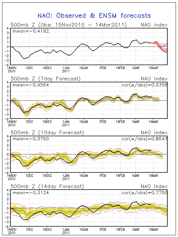
Long-range models do indicate this past weekend may have been winter's last hurrah with frost but it is a La Nina year and do not be surprised if nature tries to play an April Fool's joke on us here in Florida with a brief chilly spell or two by the end of the month and the first part of April. You see the NAO or North Atlantic Oscillation index forecast is predicted to go negative which means high latitude blocking. Focus on the top graph and the red lines. This pattern brought us vicious cold spells here in Florida this past winter, but now that it is Spring it should not be as bad for us at least! This will allow some cold air from Canada to move south. Much of Canada is still covered by snow and winter is far from done. You combine this weather index with the fact that La Nina's are known to have a winter that likes to linger and we will watch it carefully. But, I do believe most of the coldest weather will stay to our north when nature opens those wintry gates back up. We also have a much stronger sun angle to work with here in Florida which would help modify any polar air mass that tries to make a move on us. Spring begins on Sunday and I really think it is here to stay!
No comments:
Post a Comment