Saturday, March 26, 2011
Feeling more like summer for our first full Spring weekend
Saturday, March 26, 2011
Another big weekend is here and we are having a blast on Good Morning Jacksonville. You see all those smiling faces in Mrs. Napier's kindergarten class I visited this past week. We actually did a thunder experiment and talked about severe weather safety. It looks like nature will eventually make its own thunder in this forecast. These wonderful and smart kids actually did some advanced math with me to understand how weather forecasts are put together (usually kindergartners and I just count cricket chirps together to come up with the temperature, but they were ready for much more) They are lucky to have such great teachers and are now taking a well deserved Spring break. It does look the kids will have plenty of good swimming weather this weekend as temperatures today will be in the middle 80s in Jacksonville to the upper 80s in the normally warmer interior locations near Interlachen.
It is perfect weather for the Mud Run which will be human-made that is for sure out at the Jacksonville Equestrian Center. This run benefits the Multiple Sclerosis Society of North Florida and waves of teams and runners begin an adventurous journey starting at 9 a.m. and that cooler mud will feel good as we quickly heat up! The beaches will even get in on the warmth with highs closer to 80 degrees after a chilly Friday that saw most areas on the sand stuck in the 60s. This thanks to a southwest breezes will hold the sea breeze at bay until later in the day. The ocean water may only be in the middle 60s but pool temperatures around the area are now in the more comfortable lower 70s! On Sunday actual high temperatures will push well into the 80s to near 90. But this pool weather will not last through the entire Spring break and you can see why.
A huge pattern change is taking place due to unusually cold air for this time of year being pushed much farther south than normal. Washington, D.C. has its annual Cherry Blossom Festival this weekend and it will feel more like a Winter Fest. On top of all that they may have to get out the snow shovels on Sunday! Yes, winter is still kicking. At the same time this forces our polar jet stream or main storm track moves farther south and the sub-tropical jet is coming alive for the first time since February. This is the last time we saw any meaningful rain. You combine this with a stalled frontal boundary next week and we have all the ingredients for some needed rain. Talk about rain check this latest model just out! Nature will be holding its own mud run!
The very latest model runs as of this morning are showing 1 to 3 inches of rain on average across our area next week. It is hard to believe our seven day forecast is showing rain chances 6 of the next 7 days! Our last heavy downpours occurred way back on February 10th and since then we have a rainfall deficit of almost 5 inches. This was after we built up a huge surplus of over 5 inches through the first part of January and February. So right now yearly rainfall is slightly and I mean slightly above normal. Keep in mind next week will not be a total washout for your Spring break plans. So all parents including myself can take a deep breath. But we do have good chances of rain for most of next week especially on Monday and once again by late Wednesday into Thursday.
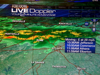
We will also have to be on the outlook for a strong storm or two. This after all is still our severe weather season and so far we have been very lucky. We were already doing some storm tracks this morning near Atlanta live on the air. This is a valuable tool our weather team uses to give you the latest and most accurate weather and I hope you will use it too! Make sure to stay tuned and go our web-site if needed tomorrow or our weather app which is updated 24/7 without delay! By later tomorrow we could be tracking storms with strong wind gusts as close to home as Waycross and Brunswick. They will move to the east southeast so they may even impact areas of far North Florida especially north of Interstate 10.
In the short term, a red flag warning is in effect for most of the area once again today due to breezy and dry conditions keeping our fire threat on the high side. Thick smoke will be likely at times for portions of Clinch and Ware County and will drift from southwest to northeast. Motorists are advised to keep their headlights on even during the day in these areas especially traveling on US Highway 1 and US 84 and 82.
We will keep you updated with your only live doppler radar. In the meantime, remember the sunscreen and to reapply the sunscreen. Today's UV index is a 10 which is the highest of the year. We will have a burn time in as little as 20 minutes.
I will be back this evening to take a closer look at Sunday's storms and help time out next week's rain for you. I look forward to seeing you. Thanks for reading!
Subscribe to:
Post Comments (Atom)


No comments:
Post a Comment