
Saturday, July 9, 2011
Happy weekend! Our weather saying is don't worry, be happy! I know the rain will put a damper on some of those outdoor plans but we really need the rain. The good news is is that it will not be an all-day rain but I do think most of us will see rain this afternoon into at least early this evening. It is not every day we track four weather-makers or in this case rain-makers but here they are front and center.
There is the anti-cyclonic flow coming from the high pressure in the Bahamas, cyclonic flow from our Louisiana low, a frontal system moving south from Georgia and "what could have been Bret" that is now moving into North Florida from the Apalachee Bay. That is right, the tropical wave we have been tracking all week tried to develop but the winds aloft were too strong and tore it apart. Now that it is moving over land it will not be a named system but at least it will help our rainfall. Thank you tropics! That is a lot of available lift and moisture. If you look at the precipitable water (PW values) from the ground to jet stream level it is at an astounding 2.3"! This is something you usually see over the Keys, or even in Jamaica not in Jacksonville. This is why I am calling this the "Jamaican Express". This is where our weather is moving from and it is looking anf feeling more like Jamaica today. Take a look at the PW bulls eye over us on this Saturday.

The PW is actually the measure of how much rain would accumulate on the surface if all the moisture in a vertical column of air is squeezed out from the surface to 36,000 feet. Since we have moisture advection and wind movement a PW of 2.3" over Jacksonville does not mean that is the maximum amount of rain we could receive, but it does tell us there is a ton of water in the atmosphere and it will not take much to set off shower and thunderstorm activity. Heck a PW value of 1.8" is really all we need this time of year for a good chance of rain with a hint of instability. Today we have taken our PW's to the limits of the troposphere. At least we do need the rain. Here is our drought update!

Yes, we have had heavy rains over much of the area the last few weeks but we still have a long way to go. An extreme drought continues from Interstate 10 northward which means 12" or more of rain is necessary to officially break the drought for good. South of interstate 10 there is a moderate drought with about 8" of rain still needed. Total rainfall for the year in Jacksonville is running about 2 inches below average and 20 inches below since the start of last year. This should make today's rain much easier to take. The latest 16 day rainfall for Jacksonville is coming in above average with 3 to 5 inches of rain! The original forecast I made way back in the middle of June for above average July rainfall still holds.

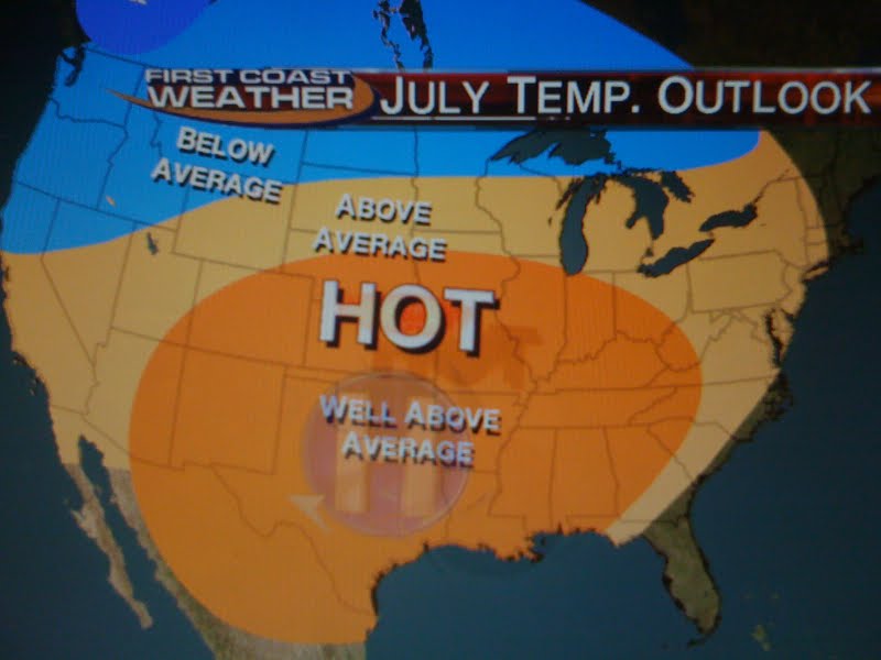
We will have to watch the tropics carefully and we have another strong tropical wave that could reach the Gulf of Mexico next weekend with perhaps an environment a little more favorable for development. But for now it is all about the rain and areas that have been missed over the last couple of days like Brunswick, Saint Simons Island, Kingland, Fernandina Beach, Lake City and portions of St. Johns County will get in on at least 1 to 2 inches of rain this weekend. If you get under a thunderstorm or two those totals will be closer to 2 to 4 inches by the end of the weekend. If you have plans remember the earlier the better both days. Sunshine will be limited and it looks like this huge slug of moisture over us will linger through at least Monday with drier air moving in Tuesday and Wednesday of next week. It will turn hot as well with less rain. Highs will reach the middle to upper 90s and it will feel like 105-110. But our next front from the north will move south and more tropical moisture will move in by late week. One other good thing about getting this needed rain is we will not be sweltering hot like the rest of the country. We will be one of the few places with temperatures near to slightly below normal through the end of July.
Have a great day and I will see you tonight. We will talk more about this wet and wild pattern taking hold here in Florida and I will have the latest rainfall totals along with your only Live Doppler Radar! I will see you soon.
No comments:
Post a Comment