Wednesday, June 15, 2011

Smoke chokes the area but there are signs of Firestorm 2011 loosening its grip on area


Wednesday, June 15, 2011

Yes, it certainly was like a never-ending severe weather cut-in during last night's weather casts. I showed one plume of smoke after another and at one point a dozen new wildfires were being tracked per hour on live doppler radar. I have never seen anything like it. I have been tracking weather all over the country for about 20 years at different media outlets and on my own since I was 4 years old drawing weather maps. I usually love weather extremes but I have put fires and smoke on the list with ice storms as my least favorite weather to track and forecast. The main thing yesterday like every day is keeping people safe and sticking to the basics. I got word out on the wind direction that may threaten neighborhoods. Luckily there were no big wind shifts and evacuations were minimal. Good for people, but bad for our lungs as the air quality went into the unhealthy range for sensitive groups.


Today we woke up with the air quality east of the St. Johns River in the unhealthy range for sensitive groups. You don't need me to tell you that. This picture sadly tells the story.  The dog walk this morning was not pleasant and we both wreaked of smoke after a very short walk. There were ashes falling on us and some of them were incredibly large like big wet snowflakes. I wish it was snow. Usually our dog can walk for miles, this morning he laid down after just a block which meant he wanted to go back inside. This smoke is hard on all of us. Those with respiratory ailments should avoid going outside as much as possible. Notice we do have a wind shift to the east southeast but not until mid to late afternoon. This means relief is on the way especially for those east of the river but this is bad news for folks west of the river including our friends in Putnam County, Keystone Heights to Lake City and up into northwest Charlton County. These areas will see the air quality and visibility go down.


What is amazing is at 10 a.m. this morning Jacksonville still had visibilities down under a mile due to smoke and smoke was causing lower visibility all the way to Daytona Beach which is about 200 miles away from the smoke source in southeast Georgia. The smoke has dimmed the sun to the point where it looks more like a glowing orange moon. I want those blue skies back and the wind shift cannot come soon enough but this is not good news for all of us. If you are in areas of northern Camden County the fire will switch direction and could pose a threat to some neighborhoods.  Here are a few fire safety tips for those near fires.


We are also closely monitoring the Sante Fe fire in Bradford County. The wind shift may cause some problems as well and firefighters are gearing up to once again keep people safe. Now we did have isolated storms yesterday but they were so far and few between they caused more fires rather than rather than dousing the firestorm of 2011 which now compromises more fires than 1998.


Now how about the rain? The CAPE (Convective Available Potential Energy) shows a very unstable atmosphere that is like a loaded gun as my teachers used to say at Lyndon State College. The problem we have is there are no frontal boundaries near us to lift the air and it is still very warm even in the upper-levels of the atmosphere. But we do have something working for us today! We have two sea breezes that will collide and a cool pool of air that is quickly moving down from the Midwest and Tennessee Valley so I have rain chances increasing late today with even a chance of rain late tonight and once again Thursday afternoon! Now the CAPE is about 3,000 over us and severe weather increases rapidly with anything over 2,000 so we need to keep our guard up not only for thunderstorms but severe weather over the next couple days. The main threat would be downburst winds like we saw off Baymeadows and Southside on Monday and in Arlington. Donna Golden sent this picture in from Arlington. Luckily everybody is okay after hurricane force gusts brought this enormous tree down on her home.


Donna Jones who I want to thank for the nice hair-cut sent me in a picture of another huge tree felled by those rowdy boomers off Southside Boulevard.


She also has family in Tuscaloosa, Alabama that was hit by those horrible tornadoes and her stories were simply captivating. I do not even remember getting my haircut. Our prayers are with her family and friends in Alabama. Our problems here on the First Coast really do pale in comparison. The story that really hit me hard was that the two most common things left of totally destroyed neighborhoods were toilets and teddy bears. She did send me some very personal photos of her home state that was ravaged and out of respect to her there really is no need to show them. You can help out in a big way by texting the Red Cross at 90999 or calling 1-800-RED-CROSS. There will be a menu of options in which you can also give to the Japan tsunami victims. You can also go to http://american.redcross.org/site/PageServer?pagename=ntld_main&s_src=RSG000000000&s_subsrc=RCO_BigRedButton to help those in dire need.

We will continue to keep you updated on firestorm 2011 and the much needed rain on the way. Here are Monday's amounts I promised I would post.

Palm Coast     3.17"
Ortega            2.03"
Arlington         1.97"
Downtown      1.61"
Callahan          1.60"
Jax Beach        1.32"
Jacksonville       1.30"
Orange Park     1.15"
Mandarin          1.10"
Springfield        0.98"
Saint Johns       0.80"
Mayport           0.51"
Macclenny        0.43"
Saint Augustine 0.40"
Palatka             0.28"
Keystone Hts.   0.15"

Most of southeast Georgia had .25" or less and with all the lightning around the storms actually did more harm than good by setting off dozens of new wildfires. One of our latest model runs for the next 2 weeks has another 3 to 5 inches of rain on the way for our area. We will need every drop of it and then some. Keep those positive thoughts going. I do not think we will see smoke this thick again and that our fire season is in fact peaking right now. This is not saying smoke will not be a problem at times over the next couple weeks but I feel like the worst is right now. Stay safe and bring on the rain nature! Stay cool too! Temperatures will once again top out near 100 and the only thing keeping some areas from the century mark will be the smoke. As our visibilities improve this weekend I see no reason why not to forecast 100 degrees. If there is good news it is the dry drought-ridden atmosphere is not causing the humidity to go through the roof like it normally does this time of year. Have a great day.

Tuesday, June 14, 2011

More firestorms than thunderstorms, more fires now than 1998!


Tuesday, June 14, 2011

New fires are being reported around the area despite last night's rain. The lightning in the area ignited new fires including a new fire in northern Camden County that has caused some evacuations near Horsestamp Place. The fire destroyed one home and 1 business. A new fire was also reported at 318 and 201 in Clay County near Highland. Another fire has fired up just south of Piccolata. Unfortunately an isolated storm and a lightning strike this afternoon near Highway 206 caused an old fire to flare back up. Here is the scene at I-10 and 295. The sky literally turned orange as I drove up Interstate 95 as smoke from the Honey Prairie fire blew in from the northwest. It has been confirmed their is now a state of emergency for Florida due to the wildfires and we have more wildfires now than we saw in 1998!

Smoke that is already thick around the area will likely not thin out overnight and mix with fog. Travelers need to exercise caution with reduced visibilities. Air quality has gone from moderate to unhealthy for sensitive groups that have respiratory ailments, especially for areas from southeast Georgia near Woodbine to Hilliard, Callahan, over to Mayport. Another problem area is from Bunnell to Palm Coast and Flagler Beach. Any thunderstorm activity tonight will be isolated and less than 5% will see any rain. Lows will be near 68 inland to the middle 70s at the beaches.

On Wednesday this smoke will start drifting west during the afternoon as the sea breeze kicks in so there may be at least some temporary relief from the smoke mainly east of the St. Johns River. But areas near Keystone Heights will see deteriorating air quality and visibilities.

Monday, June 13, 2011

Super smoke moon impresses and everything on track for some needed rain today!


Monday, June 13, 2011

I am just checking in  on my day off and two of my three daughters are home with me. There was a lot of hoopla last night over the red-orange moon in the sky. What was unusual is it was not near the horizon but well up in the sky. I have never seen a more colorful moon that high in the sky without some sort of eclipse taking place. It was caused by all the smoke from the over 100 forest fires burning in northeast Florida and southeast Georgia. The moonlight which is usually white light is scattered by smoke particles that have smaller wavelengths in a process called Rayleigh scattering. This gave the moonlight that incredible colorful glow last night. The moon will officially be full on Wednesday and it should be even more dazzling as the week goes on. The picture above was the colorful super moon we had a few months ago as it rose over the ocean. I think we can nickname this moon the super smoke moon.


Now back to today. Yes! Summer vacation is here and it has been hectic but it is good to spend time with them. I have to enjoy it while I can. The house has been cleaned, dishes done and vacuuming completed. Now it is time for a pizza lunch. Nature's menu is appetizing as well. I wanted to pass on the good news that all of our meteorological maps are still supporting RAIN today in the form of scattered thunderstorms. Check out the building cumulonimbus clouds. This is a great sign for rain. Some cloud tops could reach well over 45,000 feet. This means a few gusts that reach the ground could reach near 50 mph as the rain-cooled downdrafts have plenty of momentum by time they reach the ground due to heavy downpours. There will also be plenty of lightning with the cooler than average temperatures in nature's attic. Look to the north and west, that is where the rain is moving from. Folks in Yulee tell me it looks like a dusty scene from the Wizard of Oz at this point. The rain will hopefully clear at least some of the smoke out of the air!


The bad news is that with a west wind we will have smoke all the way to the beach which will keep the air quality in the moderate health risk range for the next few days. We also know that our area has scorching hot weather this time of year without a good onshore flow or sea breeze. Notice Sunday's highs pushed over 100 degrees in some areas. Temperatures will stay up near 100 through at least Wednesday so make sure to slow it down and there will be no relief at the beach with temperatures on the sand even well up into the 90s. My girls and I have decided to stay out of the sultry, smoky weather and we are going bowling. Yesterday I said to keep those positive thoughts and yes I really did pray in church for rain. Today keep thinking rain, rain, rain! I look forward to posting rain amounts soon! It is going to be a busy week just the way I like it. Have a great day!

Sunday, June 12, 2011

Air Quality goes downhill, but thunderstorm season is firing up!


Sunday, June 12, 2011

Well it is back. It hit me right when I left my house in the wee hours of the morning today....yes that stench. If there is good news it is the smoke should not be as bad as Friday, although if you are at the beaches the smoke has made it to the sand and piers with that light west to southwest wind overnight. Visibilities are down to a mile in St. Augustine as of 9 a.m. I do not think the smoke will hamper travel. The atmospheric temperature profile is much cooler aloft than it was on Friday. Without a strong inversion or rise in temperature with height, I do think the smoke will thin out despite a weaker, later sea breeze. It should be enough to blow it west of the river by mid-afternoon. The big concern I have is the Air Quality Index which has fallen from the good range in most of metro Jacksonville yesterday to the moderate range today. This means there is a moderate risk of health problems for those with respiratory ailments and prolonged exposure outside is not recommended. Even those with normal health will have to slow it down as the humidity starts to rise today. Heat indices could reach near 100 with actual highs of 88 at the beaches to 93 in Jacksonville. The good news is with the cooler air aloft it will also help fire at least a couple thunderstorms on Live Doppler Radar this afternoon. The sea breeze collision will actually be closer to the river today based on the latest model runs with possibly a downpour or two for even Clay and Putnam Counties. Take a look.


Yes, you see the farther south and west you go today the better chance of a storm and our friends in Georgia could even see a boomer. Any storms that do develop could produce 40 to 45 mph gusts and plenty of lightning. We are not in a severe weather pattern but we do have to remember our lightning safety rules. The great news is on Monday even more of us get in on the rain. The latest models are maps are full of color!


The best news of all is the thunderstorms should be slow-movers hopefully squeezing out an atmosphere full of water! We could see highs in the middle 90s with dew points in the lower 70s by Monday. A front from the north and a late day sea breeze could also help trigger storms all the way to the beaches. Saturday evening, Jessica Clark in Orange Park captured the storms that fired up along Interstate 75 with 40,000 foot tops. It looks like thunderstorm season is firing up!


Thunderstorm season is showing signs of life just as we discussed here on the blog since last week. It runs from mid-June through mid-October and we receive about  60% of our yearly rainfall during this period. I checked some analog thunderstorm seasons that match up with this year. Basically we had weather patterns similar to what we are seeing today in 1989 and 2008. The great news is that during both of those years our rainy season produced 36-38 inches of rain compared to the normal of about 30 inches. We average about 50 inches of year per year. Now every year is different and of course I cannot promise all this rain but I am confident we will see a much stormier summer than last year. The La Nina that helped get us in all this mess in the first place last summer is all but gone with water temperatures in the equatorial Pacific closer to average. Talk about a big change, the Climate Prediction Center has the best long-range map I have seen for us in a LONG, LONG time.


We are really in the green shading!! This is the three month outlook for rainfall that really is the heart of our thunderstorm season which is July, August, and September. We are in the above normal category. Let me look again, it is early. Wow! Yes, it is true these long-range models flip more often than freshly-caught flounder but I do like how the analog years are matching up well with this outlook. This is encouraging. I am off to church and yes I will pray for rain like so many told me they were doing during yesterday's National Day of Prayer. Keep those positive thoughts going!

Saturday, June 11, 2011

More sunshine and ocean breezes than smoke! Rain next week!


Saturday, June 11, 2011

I was looking for the oxygen mask yesterday and the calls about the smoke were through the roof. No our weather team cannot control the weather or the wild fires, but I did love taking calls and calming folks down about the worst smoke to encompass the Jacksonville metro area since 1998. At least we did not have any evacuations. I do wish I had the power to clear the smoke because I once again had to run inside on the treadmill and many kids in St. Johns County spent their first full day of summer vacation cooped up inside their homes because it was too smoky to go outside to play or go swimming. Yesterday we had the perfect storm for smoke due to a light and variable wind. Areas south and west of town had a breath of a southwest wind while areas farther north had a hint of a northwest wind. The graphic at the top shows the most active wildfires. The beaches had a light southeast wind and notice the smoke from the now more than 100 wildfires burning across the area all converged on the Jacksonville area.When it is this smoky you do need to exercise caution and try to stay indoors especially if you have any respiratory ailments. The picture below looks more like Los Angeles than Jacksonville. Here is the smoggy Florida DOT cam yesterday!


Ilyssa Trussel, St. Vincent's HealthCare Media Relations Coordinator reported to First Coast News that they are seeing a rise in the number of patients complaining about irritation from smoke. Pulmonologist Dr. Thomas Szwed, who works at St. Vincent's Medical Center, says people exercising outdoors may feel the effects. “For people who do not have known lung disease, they need to be aware of their symptoms. If they notice a lot of cough, chest tightness or wheezing, they should avoid that exercise and return to an air-conditioned, indoor facility if possible. If you have an inhaler and you work out outside, they should use their inhaler 10-15 minutes before exercise to get the bronchial tubes dilated. People who have underlying lung disease, which may include elderly people, need to be very careful when the smoke is higher,”.

If you have questions about your symptoms, call HealthLink, a free confidential community nurse advice and physician referral service. The team, consisting of registered nurses, can assist callers with medical information, as well as help locate a physician or specialist. For more information, call 800-226-5465 or locally at 904-308-5465 (LINK). They are available for phone calls Monday-Friday 8:30 AM - 4:30 PM (EST).


Today I have much better news!! Here is our new weather maker! An area of low pressure skirting east of Florida will help mix up the atmosphere. The suffocating high pressure that has also put a lid on our atmosphere has now weakened and moved west. Fresh ocean breezes will kick in and even though there will be some smoke for areas mainly west of Highway 17 it will likely be much more dispersed and not nearly as thick. Visibilities in Jacksonville at 11 a.m. are at 10 miles compared to just 2 miles yesterday. The thickest smoke today will be closer Gainesville and up to Waycross but visibilities should remain at 2 miles or greater. Thank goodness!! There could even be an brief isolated shower, although the more widespread and beneficial rain will be closer to the west coast of Florida. I think only about 5% of us see rain today. Are you ready for the best news of all. HERE. IT. IS.


R---A---I----N!!!! We have had only 4 days of rain over the past 41 although at the beach many areas have had less! Over the next 8 days we have good chances of at least scattered showers and thunderstorms for 6 of those days beginning on Monday! Yes, after all it is our thunderstorm season and it officially begins right around June 10th. For once nature may be showing us some normalcy. The latest models are showing average rainfall of close to an inch over the next week. Let it rain, let it rain, let it rain. Tonight I will talk more about this on our weather casts at 6:30 p.m. and 11:00 p.m. and if this pattern change is here to stay.

In 1998 or the last time it was this dry and smoky it wasn't a tropical system that saved us but in fact the thunderstorm season that finally came to life. We had five days of one hundred degree weather and then the pattern flipped with two to four inches of rain in just one day just in time for the start of summer. We then followed that up with an invigorating 6 to 9 inches of rain in July, and a gully-washing 10 inches plus in August.

Our maps this morning are showing LIFE and plenty of RAIN and I am hoping with all my heart we have a repeat this year. After all my original forecast was for us to actually have a thunderstorm season this year with precipitation picking up closer to average by late June. Last year our thunderstorm season was cancelled as an area of high pressure sat over us keeping it hot and dry. It not only impeded thunderstorm development but kept much needed moisture from the tropics that normally moves our way well south of our area. Our atmospheric set-up is much different this year with high pressure centering much farther west and a Bermuda high closer to where it should be off the US East Coast replacing last year's trough of low pressure. So go with the flow nature and bring it on! Just keep the direct land falling tropical systems away. You do have to be careful what you wish for.


Have a great day and a special thanks to Michael Winslow for coming in this morning on Good Morning Jacksonville. He is the man of  "10,000 sound effects" from Police Academy who will be out at Latitude 30 at 7 p.m. and 9 p.m. Looking for a good laugh you will get that and then some tonight! Michael is also ready for rain and knows all about the drought and fires here in Florida since he lives just outside Orlando. He helped me do his version of a rain dance in front of the chroma key. During my weather he made storm sound effects including "cats and dogs" since it will be raining them soon. He also had me dodging debris. Take a look at the mess at the chroma key.


LOL... It was a memorable forecast and it proves I will do anything to change this pattern. Now it is nature's turn! Have a great and safe weekend and I will see you soon.

Thursday, June 9, 2011

Storms of smoke erupt with desert dry conditions


Thursday, June 8, 2011

I wish I was singing Here Comes the Rain again by the Eurythmics but the song of the day is Fire by Earth, Wind and Fire. You can see the fire that erupted 5 miles south of Mickler's Landing just after the noon show on one of our tower cams. The Division of Forestry had earlier closed portions of A1A and actually started on both sides of it before quickly moving west. Originally there were three brush fire trucks and now there is only one and A1A is back open so that hopefully is a sign the fire is being contained. We will keep you updated on the Guana State Park fire. Our Live Doppler radar certainly has kept us ahead of these fire storms. Check out these images.


A new fire also broke out just as quickly as the first one formed. Yes, Florida is on fire.


My least favorite weather to forecast is fires right after ice storms that I experienced while living in the Midwest. Unfortunately since I started updating this blog another much larger fire called the 5x5 Breakout fire near Steckert or about 3 miles east of 121.


Yes, the drought is taking its toll with a deficit of 22 inches and counting dating back to 2010. Here is the KBDI index I showed on the noon show which shows how much moisture the first eight inches of our soil holds. When you see deep reds and purple it means it is  desert dry and Glynn County is experiencing conditions normally seen in the desert southwest. Now it is easy to see why Florida is burning and we are evaporating about .50" of water from our plants and soil a day so until our thunderstorm season kicks in and the blocking southeast ridge weakens we are in deep trouble. Expect more fires to erupt and smoky skies over the next couple of days. Next week I am still optimistic about a change. I will have an update coming your way with RAIN. Make sure to check back.

Tuesday, June 7, 2011

Easier to breathe and cooler with hope of a pattern change next week!


Tuesday, June 7, 2011

Rain clouds! I had to take a picture because it has been so long since I have seen nimbostratus clouds. Yes, most of us did see rain on Monday afternoon. I was enjoying my conversations about the rain with folks at the grocery store. Everybody was so excited! But not everybody was dancing in the rain, Fleming Island did not have enough rain to even wet the sidewalk. This is typical in Florida come June and this is why our weather team could not promise everybody rain. You just do not have large scale weather systems that can hold together this time of year as the jet stream lifts up to the Canadian border. We go from having widespread rain to convective rain this time of year which means getting that  free lawn watering is dependent on heat thermals that can weaken just as fast they form especially if you get under a thunderstorm's cooler cloud canopy. This is exactly what happened in portions of Clay, St. Johns, Flagler and Putnam Counties where the smoke and wildfires have been the worst. We also see this many times ahead of the Gulf Coast sea breeze where storms are rolling east and the rain quickly falls apart before it reaches Jacksonville due to upper-level winds pushing the cirrus clouds over our area stabilizing the atmosphere. But yesterday the rain hitting most of us was the big story  and here are the rainfall amounts I have waited all so long to post!

I-295, I-10 West Side  1.55"
Ortega                         1.33"
Downtown Jax             1.20"
Hilliard                         1.07"
Jax NAS                      0.98"
Folkston                       0.57"
Mandarin                      0.29"
Keystone Heights          0.20"
Macclenny                    0.10"
Arlington                       0.09"
Jax Beach                     0.04"
Jax Int'l                         0.02"
Mayport                       0.01"
St. Johns/Julington        0.01"
St. Augustine                0.00"
Palm Coast                   0.00"

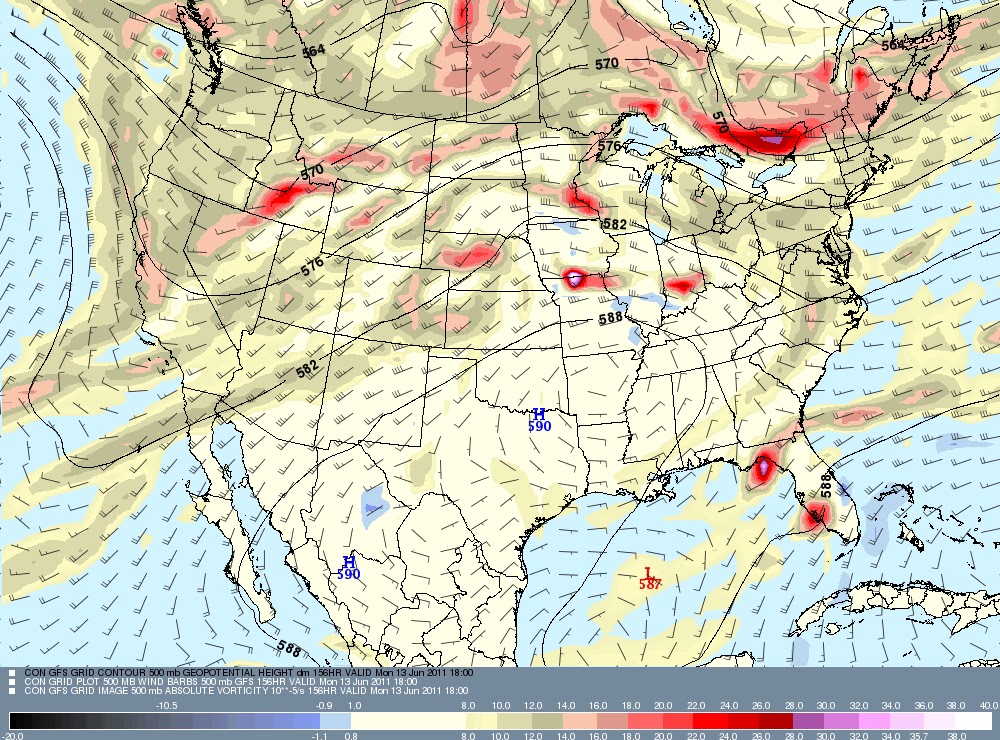
Unfortunately I do not see any big widespread rain chances for the rest of this week. The rain will be more hit than miss. The long-range models are trying to paint a rosier picture with an increase in rain and storms next week but they have been doing this for the last couple weeks. I hope this time they are right. It does look like we will be between two high pressure systems which would give us a much more tropical flow helping increase our shower and thunderstorm chances. Here is the 18,000 foot charts on Sunday.


Notice the red areas popping up across Florida. These are areas of spinning rising air and would be moving toward Jacksonville with deeper moisture and plenty of heating to work with. So I do look forward to increasing rain chances especially next week here at home. The good news for us is that the worst of the heat and the suffocating high pressure that has brought us a smoky, scorching atmosphere is not showing up anywhere close to home anytime soon. This is a sign of a shift in the pattern trying to take hold. We will take every little sign for a rainier pattern and run with it at this point. Highs should be closer to 90 than 100 which will be a nice change with areas east of Interstate 95 likely remaining in the 80s for the next few days! Yes, we can breathe a sigh of relief in more than one way. Here is the latest Air Quality Map.


Areas of yellow and orange which can cause problems for those with respiratory ailments have been pushed west of Macclenny, although it will still be smoky for area of western Clay and Putnam Counties westward and for those living in interior southeast Georgia including Waycross. This trend of the thickest smoke remaining west of the river should continue for the next several days. What we really need is several inches of a soaking rain like we saw here in early June of 1968. I know a lot of  my neighbors have been wishing for rain from a tropical system and even though none of us want a hurricane or tropical storm to strike here at home I do agree we can certainly use some moisture from a tropical system. Take a look at these rain amounts from Tropical Storm Abby back in 1968!


We could really use that 3 to 8 inches of rain as our deficit is 22 inches now dating back to January of 2010. Speaking of the tropics I  have not been really  impressed with the Caribbean Queen low that has been sitting south of the Grand Cayman island  and spinning in the Caribbean since last week. It does not look like it will develop as it moves into a more hostile atmosphere to the north over the next couple of days. The National Hurricane Center has downgraded the chances of it being a named storm from 40% to 20% over the next 48 hours. I am interested in this disorganized area of moisture because the new atmospheric flow pattern emerging here at home could pull some needed rain into Florida next week. Again this is not set in stone but we will continue to keep our fingers and toes crossed. Take a look at the the latest in the tropics. Do you see what I see?


Yes, there is an impressive swirl in the Pacific. This is the first tropical depression of the year that has formed in the East Pacific off Mexico and it it over water in the middle 80s with low wind shear. So no Arlene, but expect Hurricane Adrian by Thursday and it could reach category 2 status before it drifts northwest and weakens over cooler waters this weekend off Mexico. Last but not least in our unusual blog weather story of the day and yes there is plenty of unusual weather around the globe to pick from here is my top pick! Check it out!


Yes, they are skiing in Hawaii! Keep in mind it is not all that unusual for skiing to take place in Hawaii on Mauna Kea which is above 13,000 feet but what is unsual about this is it happened in June. Another weird fact of the day is that Minneapolis and Chicago will be about 5 to 10 degrees warmer than us here in Florida with excessive heat warnings. Yes, we should not be complaining about the weather, it could always be worse. Have a great day and keep that glass half full.