Here in Indiana we have recorded severe weather and even tornadoes in every single month of the year. Last year on February 5th we had a tornado warning in the Lafayette viewing area for Montgomery County. While Montgomery County dodged the worst of the weather, Putnam County wasn't so lucky. Here is an excerpt from last year Lafayette Weather Blog.
Here in Indiana: A possible tornado hit 10 miles south of Montgomery County last night in Bainbridge. We picked the rotation up on Live Doppler 18 and luckily it weakened as it moved into Clinton County. There were reports of trees down and damage to barns and mobile homes. There was also an 82 mile per hour wind gusts near Terre Haute brought down numerous trees and powerlines.
There were over 100 reports of tornadoes from Texas to Ohio on February 5, 2008. The Storm Prediction Center shows us all the storm reports above. It looks like something you would see in March or April. But here at home we can easily go from snow in the forecast yesterday to a chance of severe weather next week. We have a better chance of seeing thunderstorms on our Live Doppler 18 over the next seven days than snow. What a change! Some of the latest data just in does show a possibility of strong storms as close to home as Missouri by next Monday and this could easily swing our way. We will have to keep a close eye on it. Make sure to review your family safety plan for severe weather. In Florida, they had their tornado drills yesterday in accordance with severe weather awareness week and even here in Indiana we need to be reminded that tornadoes can and do happen even here at home this time of year. You can see why below.
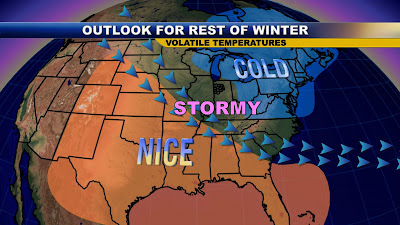
We have a clash of seasons that sets up this time of year. I am showing the lion and the lamb because here in the Hoosier state our March Madness weather patterns usually come early. Nature goes by its own calendar. This is the time of year we can have picture-perfect weather and it can be as calm as a lamb but it doesn't last very long and that lion roars back in the form of a blizzard like we saw in 2007. We also have to be on guard for ice storms and supercell thunderstorms. Sometimes we get everything in one day. We have been known to have snow and tornadoes on the same day like we saw in the winter of 1996. The frenetic February weather is punctuated in our almanac that has an almost 100 degree difference between our record highs and lows. That is incredible! This fact should be in Ripley's Believe it or Not! LOL This is the biggest record temperature range of the entire year and this week alone we will go from sub-zero weather tonight to temperatures 66 degrees warmer by the middle of next week.
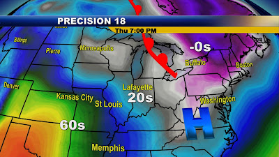
Look at the huge spread of temperatures on today's weather map. You see the clash of seasons already setting up with Spring-like 60s in Oklahoma to sub-zero weather in Upstate New York. The bigger those temperature differences, the stronger our low pressure systems that form, and the higher risk of severe weather. I still think we will hold off on any strong storms until next week and of course we will watch the flooding situation closely. I will have an update on that potential during tonight's newscasts. Hopefully we can keep the strongest thunderstorms away so we can enjoy our warmest weather of the year on the way. You see it being ushered in by our strongest warm front of the year. Get out the short-sleeves.
Yes, I finally have warm weather to talk about tonight after we just got through our coldest January since 1994. We can thank that stronger sun angle and those longer daylight hours. We can actually take a walk outside after dinner and catch up with neighbors we have not seen in weeks. A nice break in our winter weather is on the way and I do not see it returning until at least late week. Today be ready for transition weather! We could still see some blowing and drifting snow with a south wind gusting near 30 mph. Be careful on those East-West roads so you can enjoy our milder highs in the middle to upper 20s. The wind will let up tonight setting the stage for a beautiful Friday with highs back in the 40s. Have a great day!!


