Thursday, July 3, 2008

Dodging the Worst of the Storms & Getting Ready for Brilliant Sunsets


Hey Mike, I took these pictures earlier this evening, I have NO idea of how much rain we got because the wind blew my rain gauge off of its platform. These pics show the rain coming, it was awesome.

Have a Good evening and a Happy and safe 4th....

Dena Flanagan (Newcastle & Wyandotte Rd)

Here comes the clouds and there goes the sun


It is always good to hear from Dena. She always captures the weather mood of Lafayette. You can see the impressive rain shafts in the second picture. It was one of those days on Wednesday when some folks got no rain and others had a quick inch of rain near Logansport. We all missed out on seeing the worst of what nature had to offer. Notice the storm reports were mainly north of us. The two reports you see in our viewing area were just east of Bennettsville with quarter size hail and wind gusts near 60 mph.


The timing was on our side after all. It did not arrive until the wee hours of the morning so it lost of a lot of its punch. The front also ran into some drier air as it moved our way last night so that kept us from seeing any additional severe weather. This dry air was likely mixed down out ahead of the main cold front. We did have plenty of really amazing lightning around the area last night. Now the the big 4th of July weekend is almost here and the only light show folks want to see is a fireworks show. Now across our entire country there is only one big front on the map and guess where it is located. Of course it is here in Indiana. The question is where will it stall out. Drum roll please.....okay here is the answer!


Thanks to high pressure building in to our north the front should stall close to northern Kentucky and not by the Tippecanoe County Courthouse! This front will be the focus for scattered showers and thunderstorms over our holiday weekend. Here in Lafayette we will have a nice dry north to northeast flow and while we may have a good deal of clouds around on Friday, I think any rain chances should remain small! Here is the weather for Friday night at 10:00 p.m. You may even need a sweatshirt for the fireworks.


These are the kind of fireworks we all hoped for. Right now it looks like temperatures will be in the middle to upper 60s with a mix of clouds and starts. A cool northeast wind will be near 10 mph. It simply does not get any better. Just in case those clouds try to pop a rain shower or thundershower I will be at work Friday evening babysitting Live Doppler 18 just in case. It never fails to have a lone shower or thunderstorm pop up and I remember one year we had this strange funnel form in the sky even though it was sunny outside. I still have that picture in my weather room to prove it. So there are never any guarantees, but this year it is looking pretty good! Now we all know nature does not like to be outdone this time of year. Check out this display in the sky that has been repeated for the past week!


You have heard of a blue moon right? Well how about this lavendar sunshine. This is caused by smoke particles. This picture was taken in Arcata, California by Mike Kelly. These same smoke particles may also do something special to our sunrises and sunsets over the holiday weekend. I will be back to tell you all about. In the meantime, have a great day! Great job once again blogging last night.


Wednesday, July 2, 2008

Dry Air Pocket in Illinois will Keep Thunderstorms from Going Severe

None of the models showed it! We have a dry pocket that has formed in Illinois. It may be from thunderstorms to the north that helped mix down some drier air from earlier in the day. This will help stabilize the main line of thunderstorms expected to move our way after midnight. This should keep us from seeing a severe thunderstorm watch box issued. I still think it is doubtful we will see much in the way of severe weather. We not only have timing issues, but a lot of dry air for our storms to overcome. Thirdly, a complex of thunderstorms out in Missouri is sagging to the south and east of us and will also tend to zap some energy from the storms moving our way from the North. So all in all it is nice to be missing out on severe weather for once.

Although, not totally! We had an isolated report of quarter size hail and an isolated damaging wind report just east of Burnettsville. We had a low-level jet stream that collided with our warm and muggy air mass. This was enough to build a couple isolated thunderstorms even though the main front was hundreds of miles away. Tonight this same low-level jet stream or higher wind speed concentrated near the ground will collide with a cold front moving our way so we will keep thunderstorms in the forecast. But this time around it will be the kind of thunderstorms you can probably sleep to. Well, unless your a parent. I will probably have a bed full of kids and pets. It is a good thing I will be watching Live Doppler 18 until late tonight. Have a great night and I will check back with you soon!

Thunderstorms With Gusty Winds & Large Hail Moving Our Way

Latest Live Doppler 18 image continues to show more thunderstorms popping in Illinois.


A SEVERE THUNDERSTORM WARNING IS STILL IN EFFECT FOR CASS COUNTY UNTIL 7:45 P.M. A THUNDERSTORM MOVING OVER LOGANSPORT STILL HAS THE POTENTIAL OF PRODUCING DEADLY LIGHTNING, ISOLATED WIND GUSTS OF 60 MPH, AND LARGE HAIL. A NEW WARNING MAY BE ISSUED FOR MIAMI COUNTY SHORTLY. STRONG STORMS ARE ALSO FORMING IN ILLINOIS AND MOVING INTO WARREN AND FOUNTAIN COUNTIES. THESE THUNDERSTORMS WILL MOVE INTO TIPPECANOE COUNTY AFTER 8:30 P.M. WITH DAMAGING WIND AND LARGE HAIL AS THE MAIN THREATS.

Isolated Thunderstorms Popping, Lightning & Heavy Rain the Main Threats

We have had a few isolated "pop-up thunderstorms" as what I like to call them, but these are not the supercell thunderstorms we saw in June nor or any expected. With that said we could still see some lightning, heavy rain, and maybe an isolated wind gust near 60 mph. But right now the big line of thunderstorms continues to the North. Disorganized hit and miss thunderstorms will continue into the main line comes in later tonight.

Strongest Storms Should Miss Us Well North! Still Expecting a Big Light Show Late Tonight

That is right....we are not going to see the worst of the thunderstorms for once tonight! We have all walked around with a bullseye on us here in the Lafayette viewing area since late May. But as we talked about the last couple of nights, the timing was on our side this time around and even the dynamics!

The thunderstorms up near Chicago that have produced some large hail and damaging wind gusts should dramatically weaken by time they arrive in our viewing area late tonight. This main line of thunderstorms will not arrive in Tippecanoe County until after 12 a.m. Any activity before then should be isolated and not severe as the atmosphere remains capped by a ridge of high pressure. By time this ridge moves east and our storms move in we will have lost most of our daytime heating helping to stabilize the atmosphere.

A second thing in our favor will be the main jet stream that played havoc with our weather in June is well to the north. This will also help tame thunderstorms that do form. We are still included in a slight risk of severe weather from the Storm Prediction Center with plenty of humidity for these thunderstorms to work with so make sure to stay tuned for the latest just in case. Right now the main threats would be lightning, heavy downpours, and wind gusts near 40 mph.

I will check back in with you if anything changes. It will still be a fun night for all of us to track these storms together and remember no warnings are issued for lightning even though we all know there should be. Nature could put on quite a light show by late tonight.

Our Perfect World Not So Perfect By Tonight


It has been a beautiful week and I do not like using that phrase in the past tense. It certainly looked like a perfect world out at Columbian Park as you see above. You see the floating fountain globe at the zoo entrance to the Columbian Park. It was a gift from the McAllister Foundation that hooks up to water and floats. The sphere rotates and even though it took a giant crane to move its seven thousand pounds into place you can actually control which way it spins with the touch of the finger. I made sure you could see Lafayette and the sun's reflection. This solid granite sphere was made in Germany. The German word for our Wednesday is die Gewitter. Unfortunately, our perfect world is not so perfect any more. That is right, thunderstorms are back in the forecast. Take a look at the latest severe weather threat from the Storm Prediction Center.


We are in a slight risk for severe weather. Timing is everything for tonight's storms. Right now our weather team is thinking the main threats will be 45 mph wind gusts, lightning, and heavy downpours. After being lambasted in June with the most storm reports we have seen in one month since May of 2004. That was also a La Nina year. But this time around I do not see any big severe weather outbreak. The big difference will be the La Nina jet stream that spawned so many big storms in June is well north of us. The second big thing is our cold front will not arrive until the middle of the night so I do think most of our storms will occur after 10 p.m. and in some areas after midnight. This means our atmosphere will be more stable. Our lifted index will drop from an outrageous -5 at 1 p.m. to -2 when the storms arrive. Our CAPE will go from 2,100 at mid-afternoon to a more manageable 500 by later in the evening. Here are a few foot notes to help you along.

Lifted Index:

+3 to +1: Slightly Unstable, chance of showers

+1 to -1: Unstable, expect showers and possibly an isolated thunderstorm
1 to -3: Moderately Unstable, supports widespread thunderstorms


-3 to -6: Very unstable, widespread thunderstorms that may be severe


< -6: Extremely unstable, widespread severe weather

CAPE

500-1000 J/kg: Thunderstorms are possible

1000-2500 J/kg: Moderate thunderstorms, possibly severe

>2500 J/kg: Severe Thunderstorms likely

These numbers are only guides and should not be taken literally, just like our weather models.


We will watch everything carefully and our weather team will be ready if anything changes. Remember, the earlier the storms pop the worse they will be. But right now it looks like most of our thunderstorms will be after 10 p.m. tonight which should keep our storm reports to a minimum.

But if you want to see a real storm here is a great video sent to us from Iraq. This is a follow-up to some earlier pictures I showed here on the blog a couple weeks ago sent to us from Jason in Iraq.


This is a video taken from the same sandstorm that I sent pics of in May. Keep in mind that this is noon time.

Jason Jones

Thanks Jason! We will all be thinking about you and all those serving our country throughout the world over the 4th of July holiday. Pass on our best to all those serving with you! It is because of you we can celebrate and be proud as Americans. Happy Birthday America!

If you look closely at the beginning of this video you see a flash of light. This is actually lightning induced by the sandstorm. Lightning not only forms with thunderstorms, but sandstorms, volcanic eruptions, and even forest fires. A couple weeks ago a forest fire caused a severe thunderstorm to form in North Carolina. It is amazing how dark it turned at noon in Iraq. It looked about as dark as a cave. The forecast for Iraq this coming up weekend will be no sandstorms, but plenty of heat. Lows will be in the lower 80s and highs between 105 and 110. The good news Jason is the bone dry relative humidity of about 10% will make it more bearable. Stay cool and we cannot thank you enough for all you do. Please keep in touch and thanks for the outstanding weather video!


Closer to home our whole 4th of July forecast will not be as hot as a firecracker like it will be in Iraq, but cool as a cucumber! The big question mark will be if we will receive any rain. It all depends on this cold front you see above and how far south it moves. Right now it is looking promising as it should settle down near Evansville by Friday morning, but I am skeptical of all fronts this time of year that just love to stall over us. So far things are looking good! What can possibly go wrong? A whole lot so make sure to tune in tonight to view the latest on our storms on Live Doppler 18 and of course your big 4th of July forecast!

Tuesday, July 1, 2008

June Monsoon Gives Way to Blue Sky July!


Happy July! It will be a wonderful day to enjoy! I think a few people may be complaining of catching a fair weather flu. If your bosses ask you why you will not be into work today just tell them to look out the window and they will understand. If that does not work tell them to check out the weather blog to see how much you deserve a day off! Look at these June rainfall totals! Our average rainfall in June is 4.24" here at WLFI and we were about an inch above this total. Frankfort was on the verge of doubling their June rainfall. It could have been much worse. Areas south of Indianapolis had close to 18" of rain or about 6 months worth of rainfall bringing them their worst flooding since 1913.

I took these pictures on Friday night, June 27, 2008 at about 8 p.m. There is also a short video too. I live 1 mile north of Young America, Indiana southwestern Cass County. I love watching the different clouds. I was looking west, northwest when I took these.

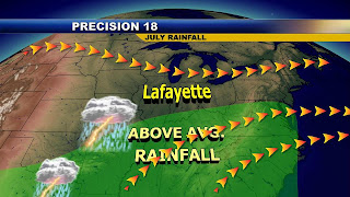
This video sent in by Katherine Forgey from Logansport shows the ominous clouds we had on Friday. It seemed like every Friday turned into Friday the 13th. It tells the story of our our June that I am calling our "June monsoon". We had severe weather on 10 out of 30 days in June or about once every three days. We had 23 wind reports, 9 hail reports, and 6 tornadoes. This comes out to an amazing 38 total storm reports. Compare this to last June when we had very little severe weather. We only had 3 storm reports (wind gusts of 60 mph or greater) the entire month with only 2 severe weather days out of 30. June 2006 was also very quiet with only 3 severe weather days and 6 storms reports (3 hail and 3 wind). I think in a more typical June we would average close to 10 to 15 storm reports with about 5 severe weather days per month. So June 2008 will go down as having about a summer's worth of severe weather! Bring on July. The question is will this continue. I do have good news. The latest long-range maps still have a weakening La Nina which is all but gone now and you combine this with a brutal heat wave set-up out West and a big Bermuda high pressure to the southeast and this spells drier days ahead. Here is my July rainfall map that shows the bullseye for heavy rain staying south and east of us.


Here is the great news! We average 4 inches of rain in the month of July and I would be surprised if we see rainfall surpass 5 inches. We will have more of a west-northwest flow. The pattern is certainly going to be different, but keep in mind I am still worried about our severe weather season lingering into July. This flow has been known to bring tornadoes to the Midwest. So even though the heart of our severe weather season is in May and June we will have to watch things carefully in July!

Now how about some real hot, hot, hot weather in July is it going to finally move our way? I can tell you we had the wettest June since 2004 and the last time we were this soggy we only ended up with 2 days of 90 degrees or above the entire summer. It was also a La Nina summer. Will this pattern repeat? I will be back tonight to answer this question on the news and check back with it here on the blog. In the meantime, enjoy our first blog song request sent in by Teri Trent. It is a perfect song that fits the mood of our weather as we begin July.

What a great request for a great day! Now it is time to head to Columbian Park Zoo. I think a train ride with the kids sounds good right about now.