Saturday, January 28, 2012
Smoke Gives New Meaning to January's Crisp Return!
Saturday, January 28, 2012
January has returned today in a big way with temperatures at least closer to normal. We should have highs in the middle 60s and forecast highs will be in the middle 60s beaches to near 70 inland. Many were looking forward to a nice walk in the crisp, winter air today but unfortunately numerous reports of smoke have filtered in from Orange Park to Green Cove Springs and Asbury Park. The DOT traffic cam tells the picture out on the west side. Our normally crystal clear Florida air in this type of weather pattern has turned hazy causing the air quality to dip into the moderate range for our entire viewing area which means those with respiratory ailments can go outside but avoid any activity with prolonged physical exertion. The light northwest wind will likely cause the stench all the way to the beach.
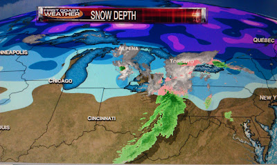
If there is any good news it is the smoke is not being caused by any large wildfires that would endanger anybody but by several controlled burns in the interior portions of Florida as you see above. The big one took place on Thursday when 2,100 acres were burned in the Osceola National Forest in Baker County. How long will it last? The wind will likely pick up out of the north and northeast on Sunday and it will help disperse the smoke. You can thank an Alberta Clipper for some fresher air by late tonight. Take a look at it bringing a nice light frosting of snow to sections of the Midwest.
This time of year we are usually not thanking these clippers that originate in Alberta, Canada and thus their name. They usually pack quite a punch and in the wake of these weather players we brace for hard freezes. This time around we do have one saving grace and that is the snow pack. If you look on the graphic above the real deep snow pack is still located where you see the purple shading. This means it will get colder with even some hats and gloves weather by Monday morning but will not have the brutal cold that we normally see. The cold air holds together and does not modify as quickly when it has snow cover to work with. Snow breeds snow and cold air! When does the colder air arrive?
The cold front above should move through right about midnight. So expect the wind to pick up and wind chills near freezing by morning! Sunday will be a true January day with highs struggling to get in the lower 60s with some coastal areas especially in Georgia only in the upper 50s. What is interesting about this pattern is the warmest winter in the United States for many areas in 78 years may turn cold in February. I say this because Alaska is having its coldest winter since 1972 in Fairbanks where I showed a breath-taking temperature of -47 degrees on Good Morning Jacksonville this morning.
Some maps have chunks of this cold air breaking off and having a better chance of moving into the lower 48 including Florida. What is happening is the main storm track is changing. The pipeline of storms that have been pounding the Pacific Northwest are taking a turn farther north! This should dislodge some cold air and help set up a deeper trough along the East Coast. One map has a few flurries to near Charleston by February 6th! Make sure to download our free weather app at FCN WX! I updated our exclusive 10 day forecast to show what I am thinking. If you do not have a smart phone I have you covered here on the blog, check it out!
Even better is we have three days with rain chances as the pattern favors stronger fronts with more moisture! Make sure to tune in tonight at 6, 6:30, and 11 p.m. and I will have all the February Frenzy details. I also do tons of weather video updates throughout the weekend at http://www.firstcoastnews.com/weather/default.aspx. I also have details on our weather video of a snow day for some kids in St. Johns County. You stay warm and I will see you soon!
Subscribe to:
Post Comments (Atom)


No comments:
Post a Comment