Sunday, September 25, 2011

Nature's Sunday Scoreboard: Tropics 16 Florida 5


Sunday, September 25, 2011

It is teal day Sunday or should I say steambath Sunday. It will feel like 100 degrees once again today. The big news this morning is our 16th named storm of the tropical season has formed in the Atlantic and its name is Philippe. You see the blob of clouds just off Africa. Philippe will likely stay a tropical storm during its lifespan and like Ophelia become a fish storm or re curve out to sea. What has been interesting this tropical season is we have had a lot of named storms but only 3 hurricanes. Our average number of storms is about 10 with 6 hurricanes and right now it is a good possibility we could go through all 21 names of this years alphabet which includes Rina, Sean, Tammy, Vince, and Whitney.

Watch the Caribbean as we head into October that is for sure with a La Nina re-developing. Keep in mind Florida's busiest month for tropical storm or hurricane impacts is September followed by October and hurricane season stretches all the way to November 30. Heck, we have even had 2 December storms. The only months without a recorded tropical system hitting Florida are January and March. Now where does the 5 come from on nature's scoreboard? Well, we should have had five hurricanes by now since Wilma last hit Florida back in October of 2005. Yes, we are in a hurricane drought to go along with our rainfall drought. Remember Wilma hit South Florida with 105 mph winds the last week of October back in 2005, so we still have a long way to go that is for sure. We need to keep our guard up. As Yogi Berra said, "it ain't over till its over" and even then with nature you never say never.


Today here at home the tropics even have a bearing on our weather. We have a tropical system trying to form into Rina off the Florida east coast. Yesterday the hurricane center gave it a 30% for development and today it is less than 5%, do to strong wind shear tearing it apart. But, I do think this weak system will steal the thunder from a front moving our way from the west. So instead of 70% rain coverage I look for 40% coverage with the best chances south and east of Jacksonville. Keep this in mind if you are deep sea fishing today.


The farther out you go to catch the big one the better your rain chance. Here at home we had more excitement yesterday with our third day in a row of funnel-filled skies around the area. The funnel cloud was spotted near Pomona Park. Check out this great picture sent in from Linda Wargo showing what all the hoopla was about. Luckily, we went to Doppler radar and the weak rotation that caused the funnel to form quickly dissipated and did not reach the ground. About one in ten of these funnels reach the ground in Florida. Luckily yesterday the wind in all directions of the upper-atmosphere were blowing in the same direction. We had a few outflow boundaries to this storms northeast and southwest that likely caused this funnel to form but there just was not enough support for it to reach the ground. 

Today I do not expect funnel weather as our helicity values or expected spin in the atmosphere is even lower with a weakening front to our west and system to our east, but never say never. All strong to severe thunderstorms have the potential of producing tornadoes and not all storms behave. No two storms are alike. My main threats today will remain brief heavy downpours and lightning. Live Doppler radar is there for us in case nature tries to pull any surprises.


The big thing once again today is that it will not be a washout and not to cancel plans. Yes, you can still go to the beach. Cheryl took this shot of some great kids taking part in Surfers for Autism yesterday at Jacksonville Beach. Thank you! This is always such an inspirational event! I wish I could stand up like that on a board. I went surfing a couple weeks ago and I am still recovering, lol! You stay cool and just think if you tune in tonight I will show you when we can open up the windows and enjoy some real refreshing autumn breezes! Hint: this time next week I will be very popular! I better go and need to head to church. Did not have time to proof read! Hope it makes sense! Have a great day!


Saturday, September 24, 2011

First fall weekend brings more steamy storms and possible waterspouts!


Saturday, September 24, 2011

Wow! This is how you want to start off your weekend. What a magnificent picture sent in from the beach this morning. The cumulonimbus clouds were casting a shadow and scattering the first rays of sunshine upward since the sun was officially still below the horizon. This is a bittersweet picture if you want a totally dry day today. This phenomenon called crepuscular rays tell us the air is full of water, dust, and salt particles that are in abundance. These condensation nucleii will help form raindrops with daytime heating today over the land areas. I do think the farther west you go today the less the amount of rain while east of I-95 we could once again see some isolated 2 inch rain amounts with flood advisories. Areas that will see the heaviest rain today will include points south and east of downtown Jacksonville. It will not be an all-day rain with most of the storms between 3 p.m. and 7 p.m. so do not cancel your plans but keep an eye to the southwest sky. That is where the storms will be moving from.


Here is one of those spine-tingling pictures sent in showing nature's raw power. Amanda captured this waterspout just offshore Mayport. I estimated wind speeds near 50 mph. Remember this time of year with the ocean temperatures in the 80s and a light and variable wind in a stagnant stormy pattern can quickly pop these phenomena. On Thursday just after 3 p.m. we had numerous boundaries collide over the ocean. There was an east-southeast wind from the ocean meeting a west wind and then add in an outflow boundary from the northwest from developing thunderstorms and you had plenty of twisting and turning in the air and the warm water added to the needed instability. You can also get waterspouts that form from a line of cumulus clouds with flat bases. The Florida Keys have most of their waterspout reports on nice sunny days!

Yesterday, St. Augustine also got in on this waterspout weather pattern. This picture is a bit blurry but you can make out another one of those ominous funnels. Are more on the way? I would not be surprised. We will have to watch those warm ocean waters and thunderstorm boundaries in this active pattern. We may not be done yet because the atmosphere is in a holding pattern with a slow-moving front likely not pushing through until early next week. The good news is that I am not expecting these waterspouts to reach land or move over land. They are being driven solely by the bath ocean water. If you are boating they can cause damage to your boat so always move away from them at a 90 degree angle.


The biggest threats today on land will be localized flooding and lightning. Be careful and remember not to cross roads covered by water. This summer steambath pattern is showing signs of releasing its grip on us by later next week. So while this is the first full autumn weekend it will actually not really feel like it until next weekend. It is this warm, tropical air that we can blame for an occasional burst of rain this weekend. But we should not be complaining. Until the relentless rain started early last week we were off to our driest September since 2003. Jacksonville is still about an inch below normal along with Brunswick. St. Augustine is still about 1.5" to 2" below normal as well especially to the north of the Bridge of Lions. Tonight at 6, 7, and 11 I will tally up some fresh rainfall totals and let you know where those storms are and where they are moving in time for your evening cookouts.

Since it will not feel like autumn until next week here is a nice autumn update from the National Park Service in the stunning Smoky Mountains.

There is just a hint of color in the earliest changing trees at this time. A few sourwoods, dogwoods, maples, and birches are beginning to show a little color, but the mountains are still overwhelmingly green at all elevations. Perhaps more notable now are the fall wildflowers such as cardinal flower, black-eyed Susan, coreopsis, great blue lobelia, skunk goldenrod, southern harebell, ironweed, and a variety of asters. The bright fruits on trees such as dogwoods and shrubs such as hearts-a-bustin are eye-catching now.

Peak fall color this year in the Smokies will be the last two weeks of October into early November. Here in Jacksonville we see most of our brightest leaves from Thanksgiving to the Winter Solstice just before Christmas! Have a great weekend and thanks for reading. Make sure to send in your pictures to weather@firstcoastnews.com. See you soon.

Sunday, September 18, 2011

Keep those plans today but summer may go out soggy!


Sunday, September 18, 2011

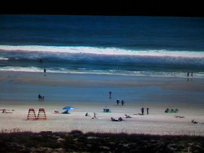
Jacksonville Beach has been the place to be if you are wondering where all your rain has been the last couple years. Notice our tower cam picking up on more strange objects falling out of the sky! Unfortunately the needed rain has not panned out over most of the area this weekend but hang in there it looks like we do have plenty of change on the way with the change of seasons! It is autumnal equinox week which means autumn begins on Friday!


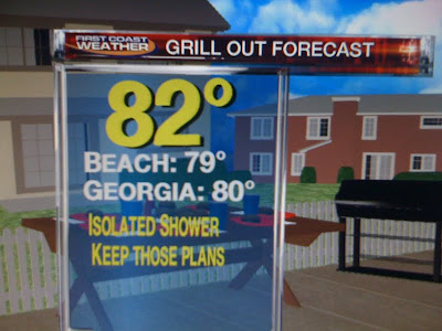
First things first. Today is a big day to grill out. It is Jaguar day and notice I made a graphic with a table full of food and a dry deck! This means we can fire up the grill with only isolated showers expected, mainly east of the river once again today. The rain will only impact about 30% of us with more teal and gray than rain. Flagler County has a flood watch closer to where the actual stationary front is located. But even there I am not expecting anything like we saw Friday night with most of the heavy rain staying south of Flagler Beach. I think Volusia County would have the better chance of any flooding on our Sunday based on the latest Live Doppler Radar scan. So here at home today the weather words are do not cancel your plans and please do grill up a cheeseburger, after all it is National Cheeseburger Day! But we just cannot keep going on like this. It is convenient we are missing out on the rain today for outdoor plans but it is not all good based on this drought update you see below.


Even Jacksonville Beach and Ponte Vedra that had nearly 10 inches of rain are still in a severe drought. The beaches have been the driest portion of our viewing area over the last couple years. Most deficits are still running at about 20 inches of rain! The low retention ponds certainly are a sign of the drought taking a huge toll on our water table. How badly do we need rain? Well I did research yesterday and Friday night was considered a 1 in 50 year flood event for the beaches that saw the deluge of rain along A1A where some spots had 3 feet of water in the road. This was still not enough to even put a good dent in the drought. That is sad! Research also shows that our chances of us seeing another more widespread 10 inch event are only at about 2% which is not good news. We just need a pattern change with several weeks of above average rain and soon before our thunderstorm season ends in a few weeks.


But we have plenty of hope on the latest model runs just in! Notice we have another major latitudinal trough or think of it as a dip in the jet stream for the East Coast late next week into the weekend. Here is what it will look like next Saturday, September 24th. So even though Ophelia is likely to form we would not see any  moisture from it as it curves out to sea. But the pattern is changing in the Caribbean and Gulf of Mexico. Notice we have an upper-level high pressure forming near Kingston. This sets up a good moisture conveyor belt for us here at home with a nice tropical southwest wind. It should really start to kick in by the middle of the week. At the same time we have another strong front moving our way from the west. This will tap Gulf moisture to work along with the Caribbean moisture. In the Atlantic a nice moist flow around the Bermuda high will set up as well. No wonder the latest models are showing maybe our soggiest pattern in weeks as we round out summer! Bring it on. Make sure to join me tonight and check back here on the blog and I will have more specifics on how much rain is on the way! See you soon. Go Jags!!

Saturday, September 17, 2011

Heaviest Rain in 3 years Blitzes the Beaches


Saturday September 17, 2011

Now that is what you call a deluge or a local nor'easter! You are looking at what portions of A1A looked like overnight especially from Jacksonville Beach all the way to Ponte Vedra Beach. These areas have a rainfall deficit of about two feet over the past two years and in one night we made up about a foot of it! There was a good swath of 8 to 10 inch rains as you crossed the Intracoastal Waterway. Several cars stalled out in the flooded roadways and some had water inside their cars up to their knees. A1A had some spots with 3 feet of water early this morning! Luckily, everybody is okay which isn't always the case when you have a flood event taking place at night. Most folks drown in their cars because they do not realize it only takes about a foot of moving water to sweep their vehicle. So the motto this morning on Good Morning Jacksonville is Turn Around Don't Drown and never cross a  roadway covered by water!


Your only live doppler radar lit up more than it had in just over 3 years since Tropical Storm Fay ambushed the beaches with over 12 inches of rain on August 22, 2008. Here is a good picture of the rainfall estimates. Notice how it was a thin, convergent band of heavy rain which is often the case with these local nor'easters this time of year. This is local nor'easter season when we can see the heaviest rainfall of the year from these weather phenomenon. It is another reason why September is our wettest month, with rainfall averaging just over 8 inches. Last night some areas saw a months worth of rainfall and then some in only a few hours! The only weather events that actually bring more rain to the Jacksonville areas would come from tropical systems. Check out some of these specific rainfall totals!


Some folks would have called in rainfall but they said they could not get an accurate reading since their rain gauges overflowed. George in Craig Field  sent this picture in showing his gauge filled to the brim as the rain bore down. Other areas this morning near Cecil Field and Keystone Heights were wondering what all the fuss was about and still have me crossed off their Christmas list until they get their needed rain. Yes, I am not everybody's best friend on this Saturday!


This rain was a huge deal because rain gauges have had more ash in them than rain drops it seems over the past several months. Our fire season which usually ends in early July has continued here into September. It certainly has been one of our longest fire seasons ever and it may just continue right into next year. Some folks at the beach cannot remember the last time it rained that hard and said it was like a wall of water that came in off the ocean in an instant. That is another reason why having the only live doppler radar is important. We do get big weather events in Florida and more often than you think.


You see what caused last night's drenching. Folks at the beach said it was an incredible lightning show to go with those mind-boggling rainfall rates of 2 to 3 inches an hour. We had a cold front stall out over the area and this was the strongest front of the season. So what happened is you had a clash of the seasons as much cooler air collided with water temperatures still in the lower to middle 80s! This created a very unstable atmosphere and you had training of rain due to the stalled out front with the perfect convergence set up as the cooler northeast wind hit the warm Atlantic Ocean.


The rest of this afternoon notice we will have more clouds than rain and I am not expecting any more flooding. The clouds will tend to stabilize the atmosphere and even though we still have a stalled front over the area the main area of low pressure will remain well offshore. Boaters will see most of the rain along with a small craft advisory well offshore with a gusty northeast wind near 30 knots. at times. So the areas that were missed last night will not have much rain to write home about today as well with less than .25" expected with many of us just remaining dry. Just keep in mind if enough sunshine does pop out in the inland locations this could be enough to cause some brief heavy downpours and this includes the Gators game. But any rain will not last very long like we saw last night at the beaches.


There officially still is a flood watch for Duval and St. Johns County which means we will be watching things closely but I am not expecting any more flooding today. Tonight we will have to watch areas from St. Augustine southward to Flagler Beach for maybe another heavier band of showers that sets up that may drop over an inch of rain along the beaches. But right now I just do not see a repeat of last night.

The second part of our weekend may bring another surge of moisture in time for Sunday afternoon but after last night let's just take it one day at a time. I do not think Sunday will be a washout by any means.

Enjoy today's cooler temperatures. Many areas, especially in Georgia may not get out of the 70s! We have real football weather! We also cleared out most of the smoke, now hopefully we can get some rain for the rest of us. The long-range models are at least favoring more rain chances going through the middle of next week. Our pattern favors more clouds and rain than sun over the next couple weeks so if you have missed out on the rain there is hope. We will talk more about this and have a drought update here on the blog and live on the air tonight at 7 p.m. and 11 p.m. Make sure to check back and tune in! Have a wonderful weekend.

Sunday, September 11, 2011

Flying the Red, White, Blue in plenty of sunshine


Sunday, September 11, 2011

We can fly the red, white and blue with pride today in plenty of sunshine. There will still be a few isolated showers and thunderstorms on your only live doppler radar but the big story will be the hot weather once again and it will be more humid with highs back up to near 90 for inland areas and the middle 80s beaches. The question is will the added humidity pop any storms. Let's look at the meteorological X's and O's.


Notice the O's represent two weather systems or nature's pass rush that is trying to get to us during the big game. But the X is our offensive line which looks like it should hold up well since we still have enough dry air in place in the middle and upper-levels and both systems do not have much moisture to bully our guards over. But we have to be careful of a turnover in the atmosphere that can happen in a hurry when a seabreeze moves onshore like we will see during the afternoon. This is the only reason I am keeping in a low chance of rain during the game. So let's check it out!


I am going for more of a roar from the Jags and crowd than nature! Highs will reach 90 during the game. But in the stands with the humidity and in the sunshine it will feel like over 100 degrees. Take advantage of reduced prices on water at the stadium since the forecast does call for 90 or above which meets the threshold. I wish I could give us a 100% of no rain but for now I am just holding the football with two hands and guarding against the turnover so I kept in a low 20% chance of a pop up shower or thunderstorm.

If something does pop I do not see a repeat of last year's two hour lightning storm. In fact, make sure you bring the hats and sunscreen. If I was going to the game I would not be taking the poncho, although my Mom always takes one for good luck since we know how Florida weather can be.


We had a glorious sunrise over the stadium this morning that bodes well for the forecast today. Now what do the models have on timing if anything does pop. Well here is the latest.


You see a few isolated showers that will try to move in with a seabreeze by early afternoon combining forces with an old dying frontal boundary with that slim chance of rain over the stadium after 2 p.m. The deeper moisture needed in the atmosphere that fuels thunderstorms looks to stay well southeast of Everbank Field.  You can see that below.


The bottom line is the main player to watch on the weather field that will bring us our best chance of rain is the trough of low pressure moving in from the west but it will not arrive until later this evening and Monday. But again coverage does not look all that great. I would say 30% or less of us see rain. 


Most of the deeper moisture has in essence been gobbled up by a tropical parade of storms over the past couple weeks. It is ashame we have had very little of this rain and it does concern me about a worsening drought and smoky conditions returning once again this week. Annual rainfall from the tropics is huge for us.

Where is the rain? Here is the answer to last night's PRANG FACT I used at 11 p.m. last night which really sums it up. Lee and its remnants have dropped enough rain to fill up Everbank Stadium 70,000 times. That is right! The United States has seen 45 trillion gallons of water unleashed by nature just by Lee. I feel like it has been a forgotten storm I think folks in the Northeast will never forget it and Lee and Irene I think will both have their names retired with the likes of Dora and Andrew. Here at home we will be lucky to see more than a few drops over the next couple days and if you do get some rain you are one of the lucky ones. God bless you and America! Have a wonderful day!

Saturday, September 10, 2011

What a difference 47 years makes! We can cheer on the home team and weather!

Saturday September 10, 2011

Here is the infamous picture of what Dora did to downtown Jacksonville 47 years ago today. Yes, the Main Street bridge was about the only thing above water despite Dora makinig a direct lanfall about 40 miles farther south. The one big lesson learned from Dora was that inland flooding can be worse than coastal flooding. This is because the shallower the body of water (which in this case was the St. Johns River) the higher your storm surge. Now the beach had multiple issues with an 8 foot storm surge and waves of 20 feet on top of that. This caused about two dozen homes to be washed into the sea. Here is what was left of the Atlantic Beach pier.


This is quite a sight and if that was not enough the Jacksonville Beach pier was destroyed along with the famous ferris wheel. Wind gusts were clocked at high as 110 mph as the eye moved ashore in St. Augustine just after midnight. Folks reported birds feeding on swarms of insects as the skies went starry. It was quite an eerie sight. Notice the track went from St. Augustine through St. Johns County near the present day World Golf Village, through Clay County, Bradford, Union, and eventually Columbia County.


While rainfall amounts were in the six inch range east of the river, they increased to near 15" by time you were north of Lake City! So inland flooding from rain and storm surge was horrific. Luckily, there was ample warning that Dora was going to hit the First Coast and that held down the fatalities to only 4 which was quite a huge feat especially back then when the National Weather Service did not even have its own radar and doppler radar was not even invented yet. Now, 47 years later we are counting our blessings in the BLESSED COVE!

Here is what it looks like out on the beach this Saturday afternoon. All our big local teams have home games, including the Gators, Noles, and Bulldogs and I think rain will not be an issue. Enjoy the nice tailgating weather as well and if you are looking for a recipe I think the shrimp and grits will do and you can find it on firstcoastnews.com. I had the pleasure of scarfing that down this morning thanks to chef Abigail. Yummy! It was the first time I ever had it and I will be fixing it for dinner next week.


Now back to weather! Yes! it was a scene of utter destruction nearly 50 years ago but just a wonderful beach day today! Even though the tropics are off to their busiest start since 2005 when we had 28 named storms, we have been in the right place at the right time. Nature is literally hitting for the cycle with 4 tropical systems. Check it out!


Let's start with Nate on the far left heading to Mexico. Some models tried to bring moisture our way from this system. I did not buy it with this system way too far south and this is one reason I kept it mainly dry.

A second circle depicts Lee or the storm formally known as Lee which is the forgotten 11th billion-dollar disaster to hit our country this year. Do you realize portions of the Northeast have seen almost 2 feet of rain from this system including about a foot in Maryland that is seeing some of its worst flooding since Agnes in 1972. So once again I have been on the phone all week with family and friends up north. I do like keeping in touch but they may need a break from me or at least nature and soon! I do think Lee will finally weaken and lift out by late this weekend with improving weather for Washington, D.C. and New York City in time for the 9/11 ceremonies. But it is Lee that has helped wrap in dry air through much of the week and the atmosphere is dry even up through 20,000 and 30,000 feet. This is another reason I have a mainly dry forecast this weekend.

The third circle on the upper right is Katia and she will be near England by early next week. Bye bye and thanks for the great surf earlier this week. The fourth system circled near the windward islands is Maria and it should follow Katia's footsteps while bringing us more nice surf by Tuesday. Get ready surfers! The western Atlantic ridge combined with troughing along the East Coast that helped us set two record lows this week is not going anywhere anytime soon. So I can give us the all clear at least through the 20th but after that maybe some changes. Make sure to tune in and check out a much busier blog!


We have to keep our guard up! It is still thunderstorm season and today is the peak of hurricane season so we have a long way to go. In the short-term there is another wave of low pressure in the atmosphere that will try to move through the area by late tomorrow into Monday. Timing will be everything especially with the Jags home opener. Right now I think the big story will be the Jags staying undefeated, not another lightning delay. But there is a 20% chance of rain and I cannot rule out a thunderstorm for the game. We all know what happened last year. So this means a special blog update will be needed late tonight and once again Sunday morning. I think our highest chances of rain will still be after 4 p.m. when we are celebrating! This is what makes forecasting fun and that is the challenge. Have a great day and I will be back soon! Take care.