Sunday, May 22, 2011
Hot enough for you? It is so hot that yesterday in my car I recorded a temperature of 140 degrees at 4 p.m. in the First Coast News parking lot. While we officially hit a high of 95 in Jacksonville yesterday there were a few locations like Palatka that reached 97 degrees and this is in the shade. If you put a thermometer in the sunshine you can easily add 15 to 20 degrees and then you can add in for type of surface and humidity to come up with the real feel temperature. Yesterday my formula came out to it feeling between 115 and 120 around town. Luckily we did not have much humidity or it would have felt even hotter. But, this also meant the atmosphere was so dry and warm at all levels that thunderstorms were unable to develop along the sea breeze front. Remember last weekend we had cold air aloft and that helped bring plenty of needed rain. This weekend it is the total opposite. We can feel it and so can the atmosphere.
This means our thunderstorm chances today will remain below 10% with maybe an isolated storm possible for Central Florida along colliding sea breeze and lake boundaries. But as you can see on this map, it is the hot weather that will win out! I do think we could hit 100 degrees in Alma, Georgia today and interior Florida on Monday! The hot high pressure is still building into the area which means we will continue to heat up. The center of the high pressure or the heat wave will not be over Jacksonville until Monday afternoon and will slowly move offshore on Tuesday. So I think we have a good shot of still making it to a record-breaking 98 degrees on Monday, then we will simmer down and see gradual improvement through the week with slowly increasing rain chances and a sea breeze that will come earlier each day.
But until then we are taking this heat seriously even if this is what we expect in Florida. We need to find ways to stay cool and this includes our pets. Rachel sent this picture to show how her dog Walter is staying cool. Yes, he just got a nice summer haircut. Thank you Rachel.
Yesterday at the Trail of Tails the Jacksonville Human Society came up with a clever way to beat the heat by setting up a doggy pool. Lori did a great job of showing this large pool. It was so hot yesterday I would have jumped in with the dogs! Lori also sent a good reminder for us humans to drink plenty of water in this heat and wear hats and sunscreen that also help keep the body cool. But back to our pets that we do love. Make sure not to take them on any errands or even think of leaving them in your car even if it is for just a few minutes. While most of us know this is a big no-no there are a few folks that do not realize even with the windows cracked open car temperatures can reach deadly readings well over 100 degrees in just a few short minutes.
I did a few experiments yesterday between shows. For instance, yesterday at 2 p.m. my car temperature in only 10 minutes reached 125 degrees with the windows rolled up. I then cracked the windows open after letting all the hot air out of the car and recorded 108 degrees after 10 minutes. Yes, cars are death traps this time of year. Keep the pets home and your cars locked when you are home so no kids can play in them as well since they do not know better. Tonight on First Coast News Jessica Clark will have more pets vs. heat safety tips.
Speaking of staying safe I wanted to give a special shout-out to the church group I spoke to in Mandarin this past week. They are from the Church of Jesus Christ of Latter Day Saints and were certainly a breath of fresh air. I want to thank Ashley for the nice invite and say a special hello to her family back in Indiana. She showed me that Hoosier and southern hospitality that is for sure! Those A&W floats were awsome! They were very impressive and were already handing out information on hurricane preparedness kits and realize that you need to buy a few things on that list each week before hurricane season really gets cranked up. That way when and if we are impacted by a storm we will be ready.
I dispelled the myth that hurricanes do not hit North Florida and South Georgia and explained how St. Augustine may not have been the oldest city in the US if it was not for a hurricane that hit the area in 1565 which allowed the Spanish to defeat the French. Not only have we had hurricanes here on the First Coast but back in the 1800s we had 2 hurricanes hit North Florida in 11 years. Overall we have had 5 hurricanes including Dora since 1565 and if you add in South Georgia which is a part of our family here at home we have had 10 hurricane strikes since the founding of St. Augustine. So whoever told you we are safe here at home now you know better. I always say prepare for the worst and hope for the best.
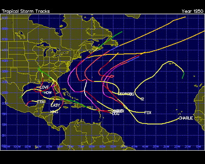
What can we expect and where will the hurricanes hit this year? That is the million dollar question. The latest NOAA forecast confirms what I was thinking which is an above average year. We average 10 storms, 6 hurricanes, and 2 major hurricanes of 111 mph or greater. My numbers are 16 storms, 10 hurricanes, and 5 major hurricanes. I have a map of all the tropical systems from 1950. This is a year that matches up well with this year. Unfortunately there were 4 hurricanes that impacted Florida just like we saw in 2004. We had a hurricane near Pensacola, Tampa, Cedar Key, and Miami. This year I do expect the west coast of Florida to be busy with a few teasers moving up the east coast toward the Carolinas. This is another reason to get prepared now.
This year looks like we will have plenty of activity in and around the Florida peninsula unlike last year when we had one lone tropical storm impact South Florida. Pressures have literally reversed compared to last year across the Atlantic and Caribbean while the water temperatures still remain well above average. It was incredible we did not have one hurricane hit the US despite it being the third most active season on record. I do not see another "miracle" year this year.
You can already see the tropics are heating up with plenty of storms flaring up. Lower average pressures combined with the La Nina and record warm water are not a good sign. While the Gulf of Mexico has high pressure at this time it looks like this high pressure will likely park over central Texas which means tropical activity will not be blocked like we saw last year when Mexico had one storm after another. No organized activity is expected in the near future due to too much wind shear but be ready. This will not hold up. I do have one of my hot spots for tropical activity stretching from Louisiana to Tampa. Two other areas to watch will be the Keys to Palm Beach and the Carolinas. While we do not know exactly when and where these storms will hit you can count on our weather team to be at our best when nature is at its worst. Have a great Sunday and please take care in the heat and stay safe!
Subscribe to:
Post Comments (Atom)


No comments:
Post a Comment