Thursday, December 1, 2011
Jack Frost Ushers in Meteorological Winter! Keeping Hope Alive for Winter Snow!
December 1, 2011
There is my daughter Lauren and she is excited today is the first day of meteorological winter. It looks and feels like it! We hit 32 on the West Side of Jacksonville this morning with plenty of frost. Now I know the calendar winter starts on December 22nd at 12:30 a.m. but that is not based on weather. Our coldest 3 months of the year on average across the United States begins today which is based on climatology and thus you can officially say HAPPY METEOROLOGICAL WINTER! Now Lauren has her "let it snow" sled out. She is a chip off her old Dad! All the kids in the neighborhood have asked me for snow. Many have never seen it before in their short lives. I explained to them that anything is possible. It will be tough though.
The overall December pattern looks warmer than drier than normal as we have discussed here on the blog and I expect this trend to continue into January and February. Now one word of caution. This does not mean we do not have the potential for unusually strong arctic outbreaks. A weak La Nina pattern can bring brutal shots of cold air. The Siberian snow cover in October into November went from normal to well above normal. This trans-Siberian pipeline makes a move toward Florida at least a couple times a year, usually in mid to late January if things set up just right. Just be ready for a few memorable days of crazy cold and if we have enough moisture then yes I cannot rule out SNOW. I am keeping hope alive based on not just my heart but meteorology. If I had to attach a percentage to our chance of seeing snow this winter...I put it at 10%, but we have a chance and that is all the kids are asking for at 30 degrees latitude or where all the world's desert climates flourish.
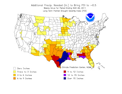
The bigger story this winter is the drought that should worsen. I am really concerned. We had all three months of our meteorological autumn with below average rainfall. This makes it four months in a row below normal. You can see the severity of our drought with the map above. We need 6 to 9 inches to break our drought, but I know it areas of the Okefenokee I think it is more like 12". Notice the poor Panhandle checking in with a 15" plus drought. This is incredible. Fire season this year was really never really snuffed out and as we head through this winter I do think we have a chance for wildfires continuing and then picking up once again by Spring. We will keep you updated on this serious situation. As I look at the latest winter precipitation forecast I get chills and not the good kind. This winter's main storm track will run from Texas to the Midwest and interior Northeast keeping us much drier than normal. This is catastrophic.
Now I have to end this with the glass half full! You know me. Congratulations we made it through another hurricane season without a major hurricane hitting the United States, but do not tell that to our friends near Jacksonville, North Carolina and New England. I will explain what our saving grace was here on the blog on Friday. Also, how we have another big weekend warm-up on the way. We will take a look at our North Atlantic Oscillation charts and it will be easy to see why. I will check back with you in a few hours.
Subscribe to:
Post Comments (Atom)


No comments:
Post a Comment