Sunday, September 18, 2011
Keep those plans today but summer may go out soggy!
Sunday, September 18, 2011
Jacksonville Beach has been the place to be if you are wondering where all your rain has been the last couple years. Notice our tower cam picking up on more strange objects falling out of the sky! Unfortunately the needed rain has not panned out over most of the area this weekend but hang in there it looks like we do have plenty of change on the way with the change of seasons! It is autumnal equinox week which means autumn begins on Friday!
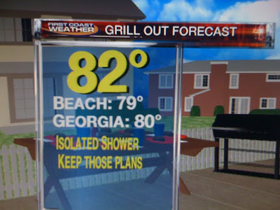
First things first. Today is a big day to grill out. It is Jaguar day and notice I made a graphic with a table full of food and a dry deck! This means we can fire up the grill with only isolated showers expected, mainly east of the river once again today. The rain will only impact about 30% of us with more teal and gray than rain. Flagler County has a flood watch closer to where the actual stationary front is located. But even there I am not expecting anything like we saw Friday night with most of the heavy rain staying south of Flagler Beach. I think Volusia County would have the better chance of any flooding on our Sunday based on the latest Live Doppler Radar scan. So here at home today the weather words are do not cancel your plans and please do grill up a cheeseburger, after all it is National Cheeseburger Day! But we just cannot keep going on like this. It is convenient we are missing out on the rain today for outdoor plans but it is not all good based on this drought update you see below.
Even Jacksonville Beach and Ponte Vedra that had nearly 10 inches of rain are still in a severe drought. The beaches have been the driest portion of our viewing area over the last couple years. Most deficits are still running at about 20 inches of rain! The low retention ponds certainly are a sign of the drought taking a huge toll on our water table. How badly do we need rain? Well I did research yesterday and Friday night was considered a 1 in 50 year flood event for the beaches that saw the deluge of rain along A1A where some spots had 3 feet of water in the road. This was still not enough to even put a good dent in the drought. That is sad! Research also shows that our chances of us seeing another more widespread 10 inch event are only at about 2% which is not good news. We just need a pattern change with several weeks of above average rain and soon before our thunderstorm season ends in a few weeks.
But we have plenty of hope on the latest model runs just in! Notice we have another major latitudinal trough or think of it as a dip in the jet stream for the East Coast late next week into the weekend. Here is what it will look like next Saturday, September 24th. So even though Ophelia is likely to form we would not see any moisture from it as it curves out to sea. But the pattern is changing in the Caribbean and Gulf of Mexico. Notice we have an upper-level high pressure forming near Kingston. This sets up a good moisture conveyor belt for us here at home with a nice tropical southwest wind. It should really start to kick in by the middle of the week. At the same time we have another strong front moving our way from the west. This will tap Gulf moisture to work along with the Caribbean moisture. In the Atlantic a nice moist flow around the Bermuda high will set up as well. No wonder the latest models are showing maybe our soggiest pattern in weeks as we round out summer! Bring it on. Make sure to join me tonight and check back here on the blog and I will have more specifics on how much rain is on the way! See you soon. Go Jags!!
Subscribe to:
Post Comments (Atom)


No comments:
Post a Comment