Sunday, April 3, 2011
Blue Skies for the Blues Fest but keep your eyes to the sky by early Tuesday!
Sunday, April 3, 2011
Good Sunday morning! The Sunday morning show was a blast at 7 a.m. I think they should stream the whole show live including what happens during commercials. I got in another dance lesson from anchor Len Kease. We had a little Snoop Dogg playing and yes I am finally learning to loosen up the shoulders. Today we will be dancing in the streets out at the Blues Fest with plenty of blue skies. You see the breakdown on temperatures at Jacksonville Beach. A sea breeze will move in this afternoon so the warmest part of the day will be early afternoon with highs in the middle 70s. Inland locations will still have no problem making it into the lower 80s. You can also fire up the boat with outstanding conditions. A tame east wind will be at 10 to 15 knots and seas only 2-3 ft. The surf will build from 1-2 feet. What most folks do not realize is that April is actually our sunniest month of the year here in Jacksonville so nature is coming through for us right on cue. We receive 73% of our possible sunshine this time of year. May is in second place with 70% of possible sunshine. Our cloudiest months are December and January. But it is not just our sunny season, April is also a month we have to keep our guard up because it is still technically the peak of our tornado season at least for the beginning of the month. Then our numbers go way down. Here is a graph showing numbers.
By mid-April we transition into waterspout season that can turn into tornadoes as they come ashore and they tornadoes that do form over our warmer summer months are usually short-lived and weak. So let's all get through this first week of April so we can enjoy the rest of the month which does look like it will bring plenty of vintage sunshine.
Here is when we will be in the storm zone. It still looks like late Monday night into Tuesday morning. This RPM model from 5 a.m. Sunday morning holds the main line off from moving through downtown Jacksonville by noon. I think it may be slow especially with the fast flow across the country. Our main threat here at home will be damaging wind gusts. You will have most of your tornadoes with this weather system here in the South taking place in northern portions of Mississippi, Alabama, Tennessee and Georgia. To my friends in Indiana, go Butler, but please make sure to have your weather radios turned on before falling asleep tonight. This is the anniversary of the Super Outbreak that hit back on April 3-4, 1974. So you know what can happen. Here is a picture from the Monticello courthouse that was destroyed.
Am I expecting a repeat. Absolutely not. But I am not ruling out isolated tornadoes moving in from Illinois and wailing sirens by late tonight. Be careful. Know where your safe spot is and have a plan of action. Yes, I still watch out for you and tell Matt Painter he made a smart decision on staying at Purdue. Now it is your turn to be smart. These are areas that will be much closer to the main lift and jet stream causing this severe weather outbreak. What is scary is that many of the tornadoes will likely occur at night. So I hope and pray folks in those areas have weather radios so they can stay up to date with the latest. Here at home we could even see this line race through in the wee hours of Tuesday but it would likely be a gusty line with 60 mph wind gusts. Even though the highest areas of shear and instability remain north of the First Coast this system is so strong we will have to watch it carefully. The good news is the bulls eye this time around is not on us here in Florida. But with that said some areas of Florida could still see damaging storms and we will continue to keep you updated with your only Live Doppler Radar. So today's lesson is we will all keep our guard up.
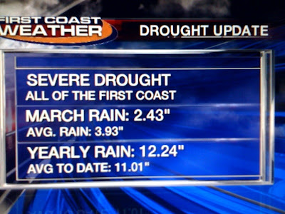
Our blog question of the day is about the drought. Despite all the rain are we still in a drought? The short answer is yes. We did go down one level of drought from extreme to severe but it is still a big issue as we head through the Spring. Notice we had a solid 1-2 inches of rain to finish March with even 3 " in St. Marys, Georgia but still ended up about an inch and a half below average. We have a slight surplus for the year after being way ahead to start the year.
The long-range models for April are showing the driest weather in Texas and not over us so that is an improvement. Don't get too excited. I am still expecting temperatures once again above average by 1-2 degrees and rainfall to once again fall about 1-2 inches shy of normal. The overall global pattern is working in our favor for increased rainfall by our rainy season so we do have hope especially with a weakening La Nina. I will have more on this here on the blog in the coming weeks. The system swinging through early this week will be a quick-mover so as a result I am expecting rain amounts closer to a half-inch or less. Enough of this rain talk, go out and enjoy the nice sunny Sunday fun day. I am heading to church and will have an update for you tonight at 6, 6:30, and 11 p.m. and of course check back with you here on the blog. Take care.
Subscribe to:
Post Comments (Atom)


No comments:
Post a Comment