Sunday, March 27, 2011
Tropical breezes blow in severe weather threat
Sunday, March 27, 2011
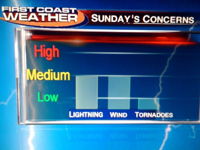
You can almost smell the rain in the air. Yes, this morning we woke up with most areas in the lower to middle 60s and with the warm tropical breezes it even felt a bit humid. We have been more like the Sahara Desert here over the last several weeks so it was a noticeable change. You combine the added moisture content of the atmosphere along with a strong cold front to our north and it should be enough to fire up at least a few showers and thunderstorms across the northern tier of our area this afternoon and evening. We will have to keep our eyes to the sky because the Storm Prediction Center still has areas from the Georgia-Florida border northward in a slight risk for severe weather. You see the graph I made shows the main threats being lightning and wind. Let's take a look at why.
It's back! The sub-tropical jet stream is helping to juice up our atmosphere and we can trace this powerhouse jet all the way back to the Pacific Ocean. So not only will we have Gulf moisture to work with but Pacific moisture. These tropical winds are not only providing ample moisture but increasing the wind shear over our area with hurricane force wind speeds at 30,000 feet over us. This energy can sometimes be transferred down to the ground in the form of damaging winds and even isolated tornadoes. Now timing is everything and right now here is the latest.
One thing to note is that most of the thunderstorm activity will stay north of Jacksonville and look to the west because I think that is where most of the storms will be moving from. So if you have big Sunday plans today, I would not cancel them. It still looks great if you are going to the UNF or JU baseball game. Even in southeast Georgia, the storms should be widely scattered and hold off until late afternoon. So just stay alert to changing weather conditions and remember if you are out and about you can follow your only Live Doppler Radar with our free weather app, at firstcoastnews.com, and on television. Yes, we have extended the 2 minute advantage to all media platforms to keep you and your family safe. I will also send out text alerts as needed.
This front has several waves of low pressure rippling along it and is parallel to the strong jet stream I showed you. So as a result it will be slow-moving and only 30% of us should see rain today. Georgia will have the best chances of strong storms and rain. Tonight with increased humidity I cannot rule out a thunderstorm or two for Florida. You see our RPM model shows some bright reflectivity moving toward downtown Jacksonville after 9 p.m. But for most of the day it looks great and enjoy our nice warm highs in the middle to upper 80s. You see Monica Landeros has already sent in a very nice shot of the Intracoastal Waterway at Vilano Beach to verify the forecast. Thanks Monica!
If you are boating, there will be a moderate inland chop developing this afternoon with a southwest wind at 15-20 knots. Out over the ocean it does not look bad at all with seas of 2 feet near shore to 4 feet well offshore. Have a great day and yes everything is still on track for all of us getting in on the rain next week, especially Monday, Wednesday and Thursday. Next weekend looks drier based on the latest European model run. Temperatures will remain warm and primarily be in the 70s throughout next week. I look forward to seeing you tonight and we will zoom in on any storms that do form. I will also post your 10 day forecast on here for you with this busy pattern ahead make sure to check back!
Subscribe to:
Post Comments (Atom)


No comments:
Post a Comment