Saturday, February 18, 2012
It will be mostly cloudy today with an increasing threat of showers and even a pop up thunderstorm mainly for our Georgia counties. Highs will be in the middle 60s north to middle 70s south.
Tonight things get interesting as a powerful jet stream moves in from the southwest. This will increase our strong storm threat especially in Georgia by late tonight into early Sunday morning. Our severe threat will continue into Sunday morning and shift into Florida with a cold front moving south. Make sure to stay tuned for your only Live Doppler Radar to keep you and your family safe.
Our main threats will be wind gusts near 60 mph but remember with any severe thunderstorm you cannot rule out isolated tornadoes.
I will be back to post some graphics and another update!
Saturday, February 18, 2012


Saturday, January 28, 2012
Smoke Gives New Meaning to January's Crisp Return!

Saturday, January 28, 2012
January has returned today in a big way with temperatures at least closer to normal. We should have highs in the middle 60s and forecast highs will be in the middle 60s beaches to near 70 inland. Many were looking forward to a nice walk in the crisp, winter air today but unfortunately numerous reports of smoke have filtered in from Orange Park to Green Cove Springs and Asbury Park. The DOT traffic cam tells the picture out on the west side. Our normally crystal clear Florida air in this type of weather pattern has turned hazy causing the air quality to dip into the moderate range for our entire viewing area which means those with respiratory ailments can go outside but avoid any activity with prolonged physical exertion. The light northwest wind will likely cause the stench all the way to the beach.

If there is any good news it is the smoke is not being caused by any large wildfires that would endanger anybody but by several controlled burns in the interior portions of Florida as you see above. The big one took place on Thursday when 2,100 acres were burned in the Osceola National Forest in Baker County. How long will it last? The wind will likely pick up out of the north and northeast on Sunday and it will help disperse the smoke. You can thank an Alberta Clipper for some fresher air by late tonight. Take a look at it bringing a nice light frosting of snow to sections of the Midwest.
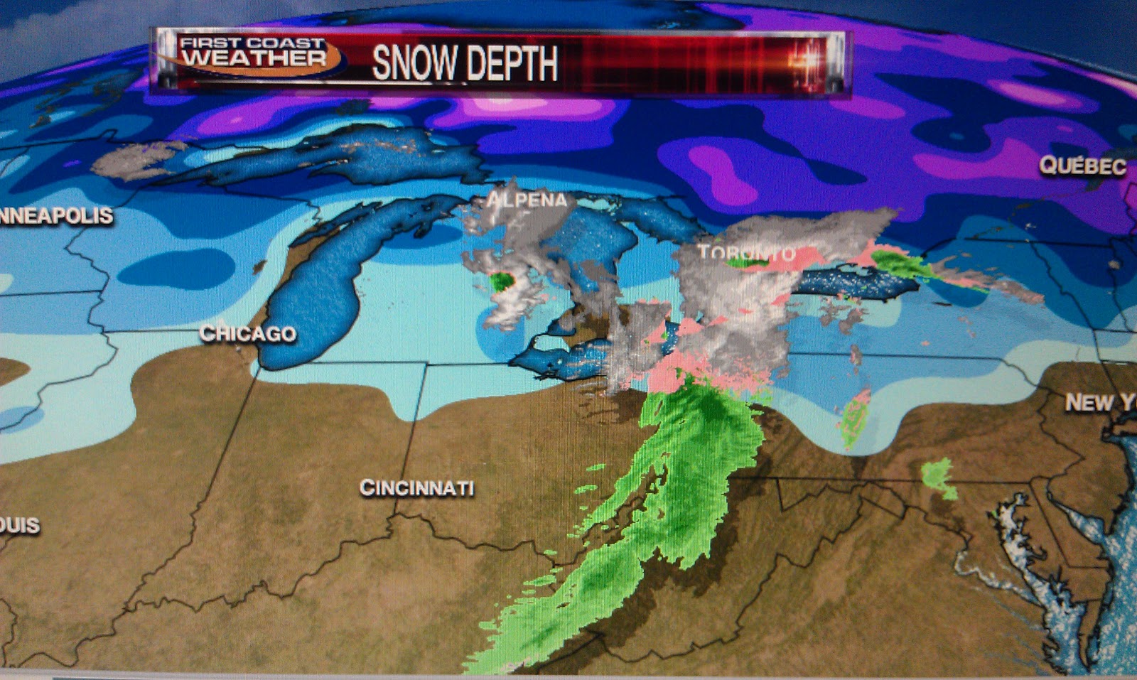
This time of year we are usually not thanking these clippers that originate in Alberta, Canada and thus their name. They usually pack quite a punch and in the wake of these weather players we brace for hard freezes. This time around we do have one saving grace and that is the snow pack. If you look on the graphic above the real deep snow pack is still located where you see the purple shading. This means it will get colder with even some hats and gloves weather by Monday morning but will not have the brutal cold that we normally see. The cold air holds together and does not modify as quickly when it has snow cover to work with. Snow breeds snow and cold air! When does the colder air arrive?

The cold front above should move through right about midnight. So expect the wind to pick up and wind chills near freezing by morning! Sunday will be a true January day with highs struggling to get in the lower 60s with some coastal areas especially in Georgia only in the upper 50s. What is interesting about this pattern is the warmest winter in the United States for many areas in 78 years may turn cold in February. I say this because Alaska is having its coldest winter since 1972 in Fairbanks where I showed a breath-taking temperature of -47 degrees on Good Morning Jacksonville this morning.

Some maps have chunks of this cold air breaking off and having a better chance of moving into the lower 48 including Florida. What is happening is the main storm track is changing. The pipeline of storms that have been pounding the Pacific Northwest are taking a turn farther north! This should dislodge some cold air and help set up a deeper trough along the East Coast. One map has a few flurries to near Charleston by February 6th! Make sure to download our free weather app at FCN WX! I updated our exclusive 10 day forecast to show what I am thinking. If you do not have a smart phone I have you covered here on the blog, check it out!

Even better is we have three days with rain chances as the pattern favors stronger fronts with more moisture! Make sure to tune in tonight at 6, 6:30, and 11 p.m. and I will have all the February Frenzy details. I also do tons of weather video updates throughout the weekend at http://www.firstcoastnews.com/weather/default.aspx. I also have details on our weather video of a snow day for some kids in St. Johns County. You stay warm and I will see you soon!
Thursday, January 26, 2012
Springtime Pattern Bringing Strong Storms By Late Tonight
Thursday, January 26, 2012
Great to be back with you! It is an exciting time at First Coast News not just with your only two minute advantage but with our new state of the art HD Weather Graphics. You deserve the best! I have been busy building away and will give you a taste of what you can expect when you tune in! Here are some graphics telling the weather story on our Thursday evening!

Notice the storm reports of a funnel cloud near Panama City that luckily did not move ashore as a tornado and the newest data as of 9 p.m. has another tree down on a house in Tallahassee from a possible tornado.
When temperatures are running 3 months ahead of schedule something had to give.

Tonight, a cold front will collide with our warm, tropical air mass and we will have to watch for some large hail, gusty wind, and even an isolated tornado especially from near Lake City to Waycross. These areas could start to see things go downhill by 11 p.m. There could be another area to our south from Marion into Putnam County where a strong storm could hold together. This would be in the 4 a.m. to 8 a.m. time frame. This is a good reminder severe weather can occur any time of year and that our severe weather season is officially less than a week away. Here is the latest risk area from the Storm Prediction Center. The yellow shading shows the areas of most concern. Below you see the storm tracks.

You can see the big wall of storms to our west with some tops between 20,000 and 30,000 feet. The tornado watch will likely not be extended east as this line moves into a more stable environment.

Closer to the I-95 corridor and Jacksonville it looks like we could have a rumble of thunder with some needed showers toward morning but unfortunately rain amounts will be at a quarter-inch or less. This weekend still looks bright but it will be brisk at times with temperatures more seasonable for this time of year. The beaches may struggle just to reach 60 on Sunday! Make sure to stay tuned for team coverage on tonight's line of thunderstorms.
Great to be back with you! It is an exciting time at First Coast News not just with your only two minute advantage but with our new state of the art HD Weather Graphics. You deserve the best! I have been busy building away and will give you a taste of what you can expect when you tune in! Here are some graphics telling the weather story on our Thursday evening!

Notice the storm reports of a funnel cloud near Panama City that luckily did not move ashore as a tornado and the newest data as of 9 p.m. has another tree down on a house in Tallahassee from a possible tornado.
When temperatures are running 3 months ahead of schedule something had to give.

Tonight, a cold front will collide with our warm, tropical air mass and we will have to watch for some large hail, gusty wind, and even an isolated tornado especially from near Lake City to Waycross. These areas could start to see things go downhill by 11 p.m. There could be another area to our south from Marion into Putnam County where a strong storm could hold together. This would be in the 4 a.m. to 8 a.m. time frame. This is a good reminder severe weather can occur any time of year and that our severe weather season is officially less than a week away. Here is the latest risk area from the Storm Prediction Center. The yellow shading shows the areas of most concern. Below you see the storm tracks.

You can see the big wall of storms to our west with some tops between 20,000 and 30,000 feet. The tornado watch will likely not be extended east as this line moves into a more stable environment.

Closer to the I-95 corridor and Jacksonville it looks like we could have a rumble of thunder with some needed showers toward morning but unfortunately rain amounts will be at a quarter-inch or less. This weekend still looks bright but it will be brisk at times with temperatures more seasonable for this time of year. The beaches may struggle just to reach 60 on Sunday! Make sure to stay tuned for team coverage on tonight's line of thunderstorms.
Sunday, January 8, 2012
First Full Moon of 2012 May Be Once in a Blue Moon

What a moon set this morning and it is not even a full moon, but tonight we have a moonrise at 5:23 p.m. and with a foggy, smoky atmosphere developing the moon may in fact look blue especially those areas that have had the thicker smoke near the Olive Fire in Putnam County. The smoke particles are just the right size to scatter the moonlight making it appear blue. Now the conventional definitions of a blue moon have nothing to do with it being blue but rather a blue moon being the second full moon in a month, which will not happen until late August or the third full moon of four full moons in a season like we saw back in September of 2010. So tonight we will keep an eye to the sky for a blue moon but also be very careful of fog and smoke.
Developing...
Saturday, January 7, 2012
Foggy to Fantasy Pattern Gives Way to Reality Check as La Nina Weakens

What a rude awakening due to a mix of fog and smoke causing near zero visibility in Putnam County. Even here downtown I snapped a picture of what looks more like San Francisco than Jacksonville, Florida. The good news is the fog will lift by late morning and the sunshine will win out. One of the drawbacks of having temperatures so much above normal this time of year is if you have clear skies it does not take much for the air to cool to its saturation point with our long nights, especially with all the real cold, dry polar air located over a thousand miles from home. But since we have a warm, tropical high pressure in control once the fog lifts we warm up in a hurry. Today expect highs to have no trouble reaching back up near 70 degrees. This is fantasy land for this time of year because climatologically our coldest week for average highs is this week! Amazing! The southern jet stream which is in charge of our Disney weather also sent us a few showers this morning but behind a weak upper-level disturbance drier air should wrap in and we will have plenty of liquid sunshine to enjoy. Check out the beaches confirming the forecast!

The surf will have some nice smooth one to two foot sets to enjoy! But it is not all a walk on the beach! The overall pattern is showing signs of change. The La Nina or below average ocean temperatures in the equatorial Pacific is now weakening. The temperatures are warming. This is the same La Nina that has brought us awful drought conditions and a fire season that never truly ended in 2010 into 2011. So good riddance La Nina. If this trend continues we can expect an increase in not only rain but an increase in cold fronts from the North. So instead of warm, dry, warm, dry, light shower, rinse, repeat....we could have a potpourri of weather. In fact we have showers and maybe even some thunderstorms are back in your seven day forecast Wednesday. This may be followed by a big chill with highs in the 50s on Friday, a nor'easter next Saturday and then freezing weather. Your weather team will have much more than a two minute advantage, how about a two month advantage! Here is the global pattern change below!

The big feature in all this is the ocean temperatures are starting to warm and this will ease the La Nina impact. Notice the jet stream forms more of a broad trough across the country and the storm track is closer to home. This means winter has not been cancelled. But keep in mind I am still favoring overall temperatures to remain above average the rest of the winter. The big change will be an increase in rainfall for us! Our friends up north will not be shut out in the snow department and this includes Maryland, Virginia, and Indiana. Texas will also receive needed rain after their driest year on record. So we are heading in the right direction.
I will talk more about drought and wildfire relief here on the blog over the weekend so make sure to check back. It is good to be back and I am very grateful I got to spend a ton of time with my family over the holidays and yes I even cleaned out the garage! Now buckle up, 2012 is looking interesting weatherwise and otherwise and it is an honor to keep you ahead of whatever nature dishes out! Tonight be careful of the fog, that is for sure! Be safe!
Tuesday, December 27, 2011
No Frightful Weather but Winter Blows Back in with a Vengeance!

December 27, 2011
Frightful weather arrives with a flurry or 2! That was the headline in last year's local newspaper. One year later I am outside running in my shorts. I want to thank my daughter Lauren for the great picture she took. My legs are more sore from playing our new Smurfs Dance Party game Santa brought her for the Wii. Maybe it will make me stronger for the National Breast Cancer Marathon which is now only 47 days away and I will finally be the great dancer I could have always have been! I cannot wait! Before I dance more to Who Let the Smurfs Out I wanted to make sure you knew no severe weather is coming our way! I talked about at least the potential over the holiday weekend.


Our next concern will be the pets and plants. Notice my Dad's flourishing garden in Mandarin that gave all the Christmas lights some competition. Yes, if you ever get lost going to the Prangleys' house just look for the house with all the flowers. His green thumb was handed down from his Dad and I am hoping like the dancing thing that I am a late bloomer and my garden eventually looks at least half this good! This was our ninth day in a row above normal today and we have not had a freeze so far in December which is very unusual. The last December to have no freezes was way back in 1994. So will we keep the freeze-less streak alive?
Yes! We have high pressure building in which usually does the deed this time of year but it is location, location, location. This high pressure originates from the Pacific Ocean not a from the Northwest Territories. Some models also show a few clouds moving in late Wednesday night and again Thursday night which would also keep us from seeing ideal radiational cooling. This high pressure is not the typical December fair weather freezer, but we should still make sure our pets have a warm spot along with bringing in the sensitive plants.
Look for frosty conditions away from the river and ocean for Thursday and Friday mornings with lows in the middle 30s at the airport and for places like Mandarin and close to the river and ocean, the upper 30s and lower 40s seem more reasonable. Our warm Spring honeymoon is coming to an end as we will have below average temperatures on Wednesday reaching only near 60! To me this still feels great outside after going through winter's in Vermont and Minnesota. I am still sure your out of town guests from the North will not mind either!

Now the question on everybody's mind is how is our last weekend of 2011 looking? I am giving it my seal of approval! It looks outstanding with temperatures back in the 70s and I still like my warmer middle 70s to near 80 by New Year's Day. But this is not an easy forecast as we head into 2012. The European Model has gone wild! You see the big blue over the southeast next week, while the other model is showing mainly warm oranges taking up much of the country. The European has highs here only in the 30s with flurries all the way to North Florida and South Georgia by next Tuesday. The other models like us cooling down to more seasonable levels with lows in the 30s and highs in the 60s.

Now which one is right? As much as this hurts to say....the European is out to lunch I think is still on Christmas break. There are no teleconnections to support this. The North Atlantic pressures remain low helping to trap the Arctic air over the polar bears and the Pacific Northwest also is showing no signs of strong high pressure building in. This would not allow a repeat of last year to form in our viewing area like last year, not even close. But I will keep you updated and we at least have memories. Check out last year! You see there was snow place like home with the surreal scene full of flakes and sago palms!
Okay now I am still all fired up about one of the maps still showing snow over us next week, even if it is a snow dream. I will be back soon to verify snow is not coming and we will also have an update on winter's return. Have a great evening! Back to the fam and dancing! Take care and don't blow away!
Sunday, December 25, 2011
Heavy Brief Gully Washers Moving North!

December 25, 2011
Merry Christmas! What a day already. I did not get much sleep but it is a good tired and my kids and family are happy. That is all that really matters. Nature has even made this day exciting for me. Notice the towering clouds at sunrise. This looks like a March scene! I cannot totally rule out a few heavy gully washers today especially from I-95 east. They will not last long but be careful. I want everybody to get to Grandma's house safely. It still looks plenty warm today with highs in the lower to middle 70s. Bobbie in Keystone Heights has already reported a high of 75!

You can see our latest rainfall estimates verifying some of those downpours early this afternoon. What is interesting is the wind is blowing northeast up to 1,500 feet and then it veers to south and eventually southwest by time you head up to 10,000 feet. This is causing the air to pile up and converge. We also have upper-level spin moving northward enhancing our lift. This mean rainfall amounts could hit a quick .25" in only about 10 to 20 minutes. Now that is impressive whenever you are talking rain rates over 4 inches an hour. It is even a bit humid outside. I cannot rule out a brief rumble of thunder but I would think that with the heavier widespread rain will stay offshore.
How about the cookouts? Well keep those plans! I think the brief downpours impacting about 30% of us will diminish by 4 p.m. over North Florida and early evening in Georgia as our upper support lifts north and northeast. It is great to see all the kids out in the neighborhood trying out their new scooters, bikes, and even go-carts. Have a great rest of your day and I look forward to seeing you tonight at 11 p.m. We will talk about a real soaker on the way and I will tell you why you may be able to wear some of those new holiday sweaters later this week! Now off to Mom and Dad's for dinner!
Subscribe to:
Posts (Atom)