Saturday, July 30, 2011
Heat advisories issued! Beat the heat with cheesecake!
Saturday, July 30, 2011
Happy National Cheesecake Day! You are looking at my number one way to beat the heat today! Drink plenty of water and find your cool spots but you enjoy a nice big slice or two of an Olympian delicacy. That is right cheesecake was fed to the very first Olympic athletes in Greece and today you can go for the gold while staying cool! I had the pleasure of tasting the Hershey's Chocolate Bar cheesecake on Good Morning Jacksonville with anchor Len Kiese. It was silky smooth with layers of moist chocolate cake and creamy chocolate frosting with chocolate chips. There was also the white chocolate cheesecake that I am hiding in the back refrigerator. Hopefully nobody at First Coast News is reading this! Shhhhhhh! I want to thank the Cheesecake Factory and remember any slice of their cheesecake is half-price. So show some love and take your date out for dessert and I bet you will forget about the heat in a hurry. You will need to. The latest heat indices at noon are a whopping 107 in Waycross to 102 in downtown Jacksonville.
This afternoon some spots could feel like 115 especially in southeast Georgia. As a result the National Weather Service has put most of our area in a heat advisory. Last year we set a record of 102 on this date and even though I think we will fall short with highs in the middle to upper 90s. It will feel like a record that is for sure. The Jaguars played it smart this morning with a short practice as you see below. It was really only a walk-through but just walking out in all that heat and humidity is tough even by Florida standards!
I really enjoyed watching the first practice on Thursday with my three daughters. They actually sat in the stands with me for over 30 minutes. Now that is love and I am so proud of all of them and so lucky! They are turning into true Jags fans that is for sure. We had plenty of sunscreen and bottles of water but it was hot in the stands on Thursday. The great part is there are cool zone fans that can cool you down if you decide you want to go cheer the teal on this evening. Just keep in mind it will still feel close the 90s to near 100 even at 7 p.m. You always have the cheesecake as Plan B or can go cool down afterwards!
Do not expect much help from nature today in the way of cooling thunderstorms. We have too much sinking air keeping the cross-wind collisions to a minimum. There may be a lone storm or two west of the river but I think our best chance of seeing rain this weekend will be on Sunday. Some of the latest models show storms igniting for about half the area if not more on Sunday thanks to low pressure moving in and high pressure moving out.
Now with plenty of moisture and heat to work with we cannot rule out a strong storm or two. I will keep monitoring it carefully throughout the weekend for you and have the latest on your only Live Doppler Radar.
These rainfall numbers are only averages and can be much higher if you get under a storm. It could certainly rain cats and dogs....speaking of cats...remember you can pick out a cat today and give it a loving home by going to the Jacksonville Humane Society for as little as 15 dollars with all their shots taken care of already.
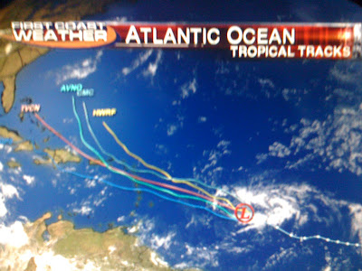
In the tropics, Don is no more! Unfortunately it fizzled out so badly before bringing needed rain to Texas. But the latest tropical wave will be anything but a fizzler. I am predicting Emily to form by late this weekend at a tropical storm. Emily will not only be the season's first hurricane but likely a major hurricane with wind speeds over 110 miles per hour. If you look at the forecast tropical tracks this morning notice more than half of our best models are indicating that it will likely curve out into the open Atlantic by late next week and weekend but since it has yet to form it really is too early to speculate. One thing is for certain and that is we should have some big surf here in Florida by Friday! Just be careful of the rip currents. I do expect an active hurricane season and we are way ahead of schedule already on named storms. Take a look!
We are already about 3 named storms above average and keep in mind 90% of all tropical cyclone activity occurs after August 1st. This is not a good sign and is another reason to make sure you prepare now. First Coast News will be airing a hurricane special this coming up Thursday at 8 p.m. I think you will enjoy it. It is not your typical run of the mill hurricane special and includes a home....well I cannot give it away. You will just have to watch! Have a great day and make sure to send in some pictures of how you are staying cool...cheesecake eating and all!
Subscribe to:
Post Comments (Atom)


No comments:
Post a Comment