Monday, April 18, 2011

Gearing up for a week of heat and more shooting stars than rain showers!


April 18, 2011

The drought is really catching up to us in more than one way. Of course we heat the atmosphere from the ground and typically this time of year a southeast flow off the ocean would be more than enough  to keep temperatures closer to normal in the upper 70s and lower 80s. But after a wet start to the year we are running about 2.5 inches below normal since March 1st. Also the main storm track is staying well to our north with more severe weather likely in the Midwest. All these factors mean the heat is on! This dry ground heats up in a hurry and as a result I do think temperatures will top out in the upper  80s to near 90 most of the week. It will feel more like June than April. The humidity will be on the increase and it could trigger a sea breeze thunderstorm the next couple afternoons but right now the main sea breeze collision would likely take place near Interstate 75. I think the most common type of cloud you will see in the sky will not be cumulonimbus or thunderstorm clouds but the pyro clouds you see above. Yes this is the name of clouds caused by wildfires. We have at least two dozen of these going on in our viewing area. Sometimes if they grow large enough in scope and size they have been known to spark thunderstorms but I do not see that happening here at home. Late week will feature a front making a move on the First Coast but it will likely stall to our north keeping rain chances on the low side Thursday and Friday. Easter weekend right now looks like a stronger ocean breeze will kick in but it will remain sunny and dry with above average temperatures in the middle to upper 80s. Yes, so make sure to water the plants and follow any water restrictions in your area.

One other interesting note this week is the Lyrid meteor shower will start heating up as well and peak Friday night into Saturday. I will have more on the blog on this during the week. Look northeast especially after midnight to just before the sunrises. Take care and I will see you soon! Tonight make sure to catch the underrated moon and I will post some pictures here on the blog tomorrow and have a pattern change update and let  you know if it will hold off until after Easter!

Sunday, April 17, 2011

Shimmering sunshine to a Spectacular Full Moon Tonight!


April 17, 2011

Picture-perfect pelican weather is on the way today. Thanks to Tressa Keller for sharing this beautiful photo from St. Augustine. Today nicer weather will swoop in thanks to high pressure. It is the beaches grand opening parade day today and it looks great for all the floats and activities. It will be sunny with a nice light northeast sea breeze moving in. Highs will be in the middle 70s. Inland areas will be in the upper 70s to near 80. This is long overdue in a month that has brought an unprecedented 4 record highs. Not only will it be comfortable but the rip current risk will remain on the low side. Most folks do not realize that rip currents, heat waves, and flooding kill more people every year than lighting, hurricanes, and tornadoes. Just make sure you know that you can still have rip currents even on quiet days especially near piers, inlets, and jetties. Today you can enjoy a nice dip in the ocean after the parade with water temperatures now in the lower 70s. It will be a terrific boating day and a good day to go to the blessing of the fleet at the Jacksonville Landing at 2 p.m.. A northeast wind will be at 10-15 kts. and seas only 2 to 4 feet with a light inland chop. Yesterday it was brutal on land and at sea. We had folks having a tough time just getting in their boats with tropical storm force wind gusts of 41 to 48 mph rocking us and this occurred without any thunderstorms! There were a few trees down across the area including at the big Boat Show at Metro Park. Stephanie Bickers captured wind damage to trees and folks holding on during some of those vicious wind gusts.


We were very lucky even with a few damage reports around the area yesterday. The reason for the relentless wind was the result of what some meteorologists are now calling the Super Outbreak of the 21st Century. This is due to the sheer number of tornadoes over the past 3 days now estimated close to 230 from Oklahoma to Maryland. North Carolina had its most tornadoes since at least 1984 with dozens of fatalities. We stayed on the dry, windy and warm side of the storm and came within one degree of the record high of 90 set in 1972. This monster storm has now been replaced with high pressure that will settle in for the next couple days. This is perfect timing because we have the full moon tonight!


Tonight's may not be the biggest full moon in 18 years like we saw last month but it will be pretty darn close. Tonight's moon is only 941 miles farther away than last month's super moon. I do not think you will be able to tell the difference between this one and the super moon so I am calling it the spectacular moon! Yes it will still be much brighter and bigger than normal and one of our biggest moon's of the year since it is at perigee within 22 hours of being full. Look for a crystal clear moonrise at 7:48 p.m. and I do expect another brilliant red moonrise like Donna Deegan took for us with the Super Moon above. Our drought continues and without a lot of rain to cleanse the atmosphere there are plenty of particulates in the atmosphere to give the moon an extra colorful glow as its light is reflected and refracted many times over before reaching our eyes!


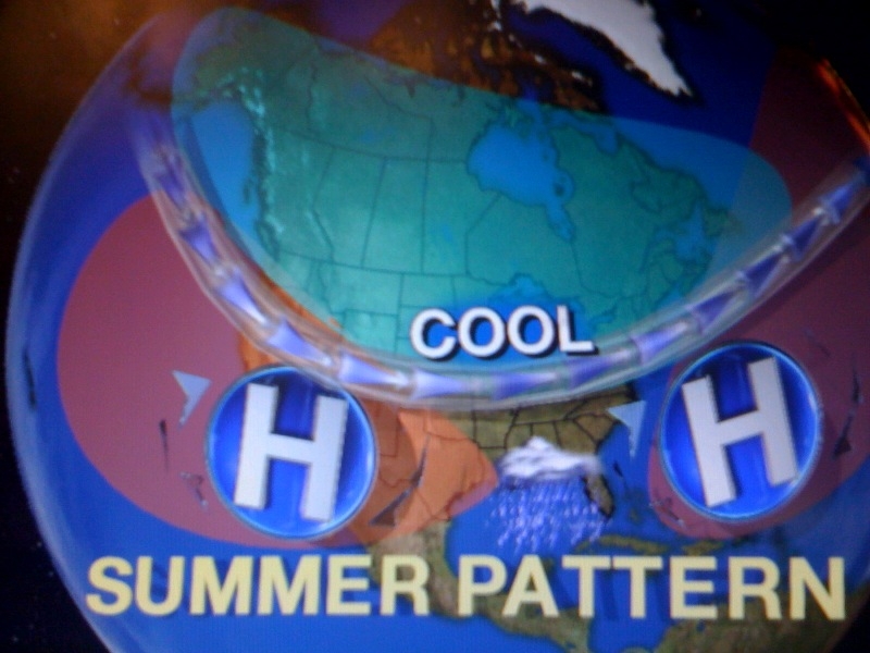
Speaking of the drought it looks like it will be once again catching up with us this week. As our main storm track stays north we stay mainly dry and  look for temperatures to once again take off to near 90 degrees by the middle of the week. Some models are showing a wetter, cooler pattern developing next week but right now I think it is safe to say we may have to wait on thunderstorm and tropical season for our rain to really kick in. So keep on watering and I will keep you updated. The good news is that my long-range outlook for the summer has us closer to normal on rain and temperature thanks to a weakening La Nina and high pressure setting up in Texas. Check out the map below with plenty of hope for us! If you are in the Midwest it does look cooler and unsettled. Send us some of your rain please!


The only concern is the weakness in the atmosphere between the two high pressures will be an increased tropical threat to Florida this year. Tropical systems like to move around high pressure systems and the steering currents do not look very kind to us here in the Sunshine State. It looks like our high risk areas will be the Carolinas, South Florida and the Florida panhandle. This is the total opposite of last year when we had a blocking high pressure over us and it kept the tropical cone of concern over the southern Caribbean as went into drought conditions. It will be interesting to watch. Speaking of interesting, our weather blog question of the day was dealing with those unusual rainbows in the sky on Friday. Here is a picture sent in by Heather Patterson.


It is tough to make out the rainbow colors in this picture but it is a great shot of the halo around the sun that was visible. What folks were really seeing was not rainbows, but a phenomenon called ice halos. Rainbows are caused by sunlight refracting off the back side of rain drops. With halos the sun's light is actually being refracted off ice crystals creating the same prism effect, only the light is going through hexagonal ice crystals which causes the ice halo effect you see in this picture rather than the rainbow caused by rain that arcs across the sky. These high clouds were out ahead of the Super Outbreak that thankfully missed our area and today we will certainly all be counting our blessings. Have a wonderful day and thanks for reading. I look forward to checking in with you tomorrow to talk about the Lyrid meteor shower on the way this week. What a week ahead with a full moon and shooting stars! This is what it is all about.

Saturday, April 16, 2011

Windy record-setting Saturday brings trees down outside of storms!


Saturday, April 16, 2011

It has been a wild Saturday across the South and we are certainly very lucky here at home. A stormy system that has spawned over 100 tornadoes over the last couple of days with several fatalities is bringing us quite a wind storm. We did have an isolated thunderstorm in Georgia this morning and early afternoon but no damage reports were received and it did not last long. The big news is we have had 40 to 45 mph wind gusts in a hazy, sultry afternoon atmosphere as you see at Everbank Field. Reports of downed trees have been received in Mandarin. There are also a couple wildfires that have been whipped up especially in Marion County. The wind is strong despite having no storms in the area because of the intense low pressure moving through the Carolinas at this time coupled with a strong jet stream. Take a look at our saving grace here at home below.


We are talking about a polar jet stream with winds in excess of 140 mph causing massive wind shear and instability across the Carolinas. This was located far enough to our north that it actually helped air to sink over our area which is not conducive for storms. This map also shows most of the deep level moisture in green which is a necessary storm ingredient lacking here at home. Unfortunately, areas to the north were not so lucky and the Middle Atlantic states including Maryland could be next.


We could have used some rain with this system but most areas were shut out. There was one isolated spot southwest of Folkston that had about .50" of rain. Last night you see the impressive ring around the moon that normally brings a 70% chance of rain but as our weather team expected we were only calling for a slight chance of rain south of Interstate 10 and the forecast held true. Speaking of the moon, it will officially be full Sunday evening and behind this wild wind front things will settle down just in time. In fact by late tonight the wind will go calm and the skies will clear. Your weather pick of the week is Sunday with splendid sunshine and highs in the middle 70s by the sand castles and near 80 inland. Water temperatures are more comfortable now in the lower 70s with a low rip current risk just in time just in time for the official opening of the beaches! There is also another phenomenon you can look forward to in the sky including what makes this full moon unsual. I can tell you it is not a super moon but close! I will  make sure to have more on this here on the blog and tube. Stay tuned!

Friday, April 15, 2011

Weekend rain looks more like a spritzel! Do not cancel plans.

Friday, April 15, 2011

Well we do need the rain but it looks like we are going to miss out on most of it this weekend. This means good news for all our weekend plans and bad news for the drought. The main jet stream is just too far north and we have too much dry air in place. If we do see any rain on Saturday it should be confined mainly to interior southeast Georgia in the morning hours.

Expect a strong line of thunderstorms north and west of Tallahassee by 4 a.m. to quickly weaken as it races northeast. Our latest model data has it almost totally falling apart by time it reaches interstate 95 in southeast Georgia. If the storms do find a way to hold together near Waycross there could be a few isolated wind gusts in the 40-50 mph range but for right now our severe weather chances also look to remain small. The Storm Prediction Center has put extreme southeast Georgia in a slight risk so we will continue to  monitor it for you just in case with your only Live Doppler Radar.


 For northeast Florida rain chances look even smaller with most of the activity in the form of a brief rain shower mainly north of Interstate 10.
 
This line will likely fizzle out as it moves into northeast Florida with rain chances remaining on the low side. This front is a big wind-maker so be careful fishing with small craft advisories in effect.There could be some gale force gusts offshore and even near shore wind gusts could be near 30 kts. Sunday looks like the much better boating day with a lighter northeast wind and pleasant sunshine!.

Wednesday, April 13, 2011

From the 3 H's to the 3 C's! We will be wishing for this weather in a few short weeks!

Wednesday, April 13, 2011

We have gone from hazy, hot and humid with a record-setting April to clear, comfortable and calm. We have earned this after setting 4 record highs this month. It looks like this refreshing weather will hang on for at least one more day before the humidity comes back up which will increase our rain chances. We need to enjoy this before our humid season kicks in by the middle of May which is just a few short weeks away. Tonight look for great sleeping weather and ideal radiational cooling conditions. Lows will drop into the upper 40s in southeast Georgia to the lower 50s at the airport. The beaches will be in the middle to upper 50s. Enjoy the bright moonlight tonight which is now 61% illuminated and with the great visibility thanks to high pressure you can check out Saturn and Titan its largest moon!

There is a parade of storms across the country but the main storm track remains well north of our area. As a result, even though there are rain chances on Friday and Saturday it does not look like a huge deal at this point with rain amounts likely staying under .10" in most areas while being scattered in nature. So that is what we like calling a spritzle of rain in the forecast.

I will be back this evening to take a look at just how unusual April has been and what it means for our summer!! Will we see 99 days of 90 or above again? Brb but first I will see you on-air this evening!

Sunday, April 10, 2011

Dog days of April will challenge all-time record record highs for entire month!


Sunday, April 10, 2011

The forecast has gone to the dogs! It was so hot yesterday I had a report of 111 degrees on a car thermometer. Of course this was not official with our hottest temperatures in the lower 90s, but it does go to show you how hot the sun-heated pavement was yesterday. Hopefully you did not forget to put on the flip-flops. Ouch! Keep in mind our forecast temperatures are always shade temperatures taken about 5 feet above the ground in grassy areas. If I was forecasting an actual temperatures taken in the sun, I would absolutely have called for highs near 110 this weekend. So with all the heat out there Peyton Taylor from the Humane Society reminded us not only to find a cool spot for ourselves but for our beloved pets. Thank you Peyton for sending these pictures in showing Barkley staying nice and cool by eating ice to go along with the scrumptious southern inspired dog treats. It was a pawriffic pet social at Confederate Dog Park. We officially hit 92 in Jacksonville yesterday. Today I think will be the hottest day of the entire heat wave with a high of 93. Check out these impressive stats and yes it is one of our earliest heat waves on record!


Normally we have the dog days of summer in July and August and they are named after the dog star Sirius that becomes prominent. But with highs today reaching what we normally would see in July, we can say the dog days have come a bit earlier this year. Yesterday was our earliest 92 degree day since 1967 and something to keep an eye on is the all-time record high for April which is 95 degrees. We will come within only two degrees of this today with a forecast high of 93. The ground is so dry and high pressure is so strong that we could make a run at this record as well today. The hottest April 10th when 90 degrees was recorded in 1999 does not stand a chance. We will smash that CD(modern day version of record)! I can say I do remember listening to Billy Joel records in Elementary School. Now it is all about CDs, even though I do still have cassette tapes....lol. But remember I didn't start the fire, nature did! The map looks scorching below!


How impressive! It is an eye-opener! We have a jet stream looking more like a roller coaster and it will move toward the US-Canada border bringing record highs in the 80s all the way to Michigan. At the same time the sharp trough out west has brought snow advisories to 8 states including thunder snow to Flagstaff. We have had temperature ranges from -2 in California to 105 in San Angelo, Texas this weekend. It does not get any wilder. A least a chunk of the cooler weather out west will move our way. By time it gets here it should modify and be a nice pleasant air mass.

A lot of folks including anchors Deanna Fene and Len Kiese have been worried it is going to stay hot all the way through the summer. At this time I do not see this happening. The hottest part of April is this weekend and we may not see 90s again until May. In 1967 the last time we were this hot this early the summer turned out to be rainy with temperatures below average. So there is hope for not only a cooler summer but drought relief. It was also a year where we had a weak La Nina which matches this year's pattern. Tonight on the news I will share my entire summer outlook. A hint is the high pressure that has brought us this record heat is heading west. This could also mean an increased threat of hurricanes to the East Coast and I will take a closer look at this here on the blog in the near future.


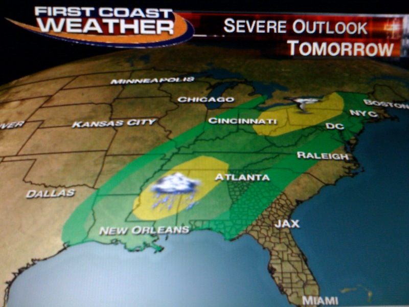
It will be another dangerous day in the Midwest after 19 tornadoes were reported yesterday along with over 360 damaging wind and hail reports. This included an EF3 or greater tornadoes that moved through Iowa. It was their strongest early season tornado in 10 years! The good news is this line of severe weather should weaken considerably as it moves East into our dominating area of high pressure. Notice how the higher risk areas in yellow and red today (above) fall apart by Monday (below).


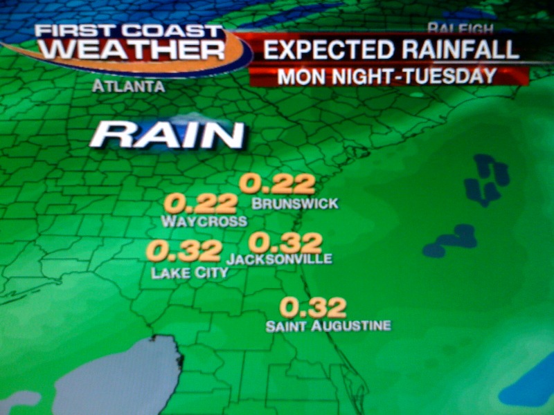
By time this line moves our way there should not be much left to it by time it arrives late Monday night and Tuesday. It is lacking deep moisture and all the dynamics quickly lift north. At least our rainfall map is still showing a free lawn watering with about a quarter-inch of rain. But, I still cannot promise that everybody will see rain as this front moves through in a weakened state.


So in this forecast today it is all about staying cool and smart in this short heat wave with plenty of pleasant temperatures on the way next week. I have highs in the 70s now for Tuesday through Thursday with more chances of needed rain by next weekend. Enjoy the rest of your weekend and thanks for reading. See you tonight at 6, 6:30, and 11 p.m. with a check on this historic weekend heat wave and more on the relief! So much to talk about and so little time. Thank goodness for this blog.

Saturday, April 9, 2011

Ring of fire pattern brings us the heat and it is here to stay


Saturday, April 9, 2011

Wow, temperatures are quickly rising out there and even though climatology tells us Jacksonville does not average a high temperature of 90 until June 23rd today nature will fast-forward us right into summer. I do think Jacksonville will tie its all-time record of 90 set back in 1978. Find a cool spot and yes a sailboat will do. I think we have a good chance of at least tying if not breaking all the records you see above. So this pattern is here to stay for at least a few days until our high pressure weakens which would not be until Tuesday. We are in what I am calling a ring of fire pattern across the country. The map you see below shows a ring of storms firing up around the cooler periphery of our large scale high pressure system bringing this record breaking warmth.


Since thunderstorms need cooler air to form in the upper-levels that is what you have a ring of fire develop. This is more of a summer pattern that is for sure. What is interesting is I cannot rule out another 1,000 or more storm reports this week with another major severe weather outbreak. Last week we had over 1,400 damage reports, including a record of over 1,032 damage reports in only 24 hours before nature sent damaging winds through our area. This time there will be more tornadoes and they could be the long-track tornadoes especially in the upper Midwest. Watch out Wisconsin and Minnesota, especially by later today and tonight. Then this activity will move east. I think the main battleground should stay north of Florida this time around, but we will still have to watch for fringe effects. We are due for a break after two crazy weeks. I do not expect scenes like this to be repeated here at home like you see in Keystone Heights.


This shed was lifted up and over a fence and there were dozens of trees that were downed in estimated 60 mph to 70 mph straight line winds. Seven homes were damaged all in about a 3 block area. Yes, we have had our fair share of severe weather and the good news is our chances of any severe storms will remain small. Here is how small.


If you are heading to Augusta to see the Masters things could get very interesting with a better than 60% chance of strong storms. Hopefully they do not lose another magnolia tree due to wind damage. Closer to home we could see some fringe effects with maybe an isolated storm firing along the cooler outflow boundary and sneaking farther south. But chances of any thunderstorm activity right now are 12% for Waycross, 8% Brunswick and only 5% for Duval and Nassau County. Since we are shaded in green this means anything that does develop will need to be watched closely with the main threats being damaging wind, lightning and hail. What I think we will likely see is what Lori and her hubby sent me in this morning from the River Walk where the First Coast was kicking it up again today! Great job!


The skies above were filled with debris clouds or a few cirrus clouds that blew off of the tops of 40,000 foot thunderstorms last night that stayed to our north. They brought us a hazy start to our morning. Even though my garden needs the rain it looks like our big story will be trying to stay cool. Make sure to find a cool spot and do not leave your pets in cars. They can heat up over 100 degrees even with the windows cracked in this kind of weather. Also, make sure they have their water bowls filled with water. My hats off to all the folks at the Diabetes Walk this morning here in downtown Jacksonville. Several thousand people made a difference while walking about  3 miles. The Jacksonville Jaguars led the walkers onto Bay Street. Organizers were hoping to raise over 500,000 dollars. As I said on the air this morning I am glad we have a nice weather day and here is another shot confirming it! Wheeewww! The pressure is off!


Stay cool and I will keep you updated throughout the weekend on the air and tube and we will take a closer look at record highs all over the country including who hit 105 degrees and who was below zero!! We will also have an update on another severe outbreak that will impact more than 20 states over the next couple days and what this stormy front will mean for us as it arrives here at home by late Monday night and Tuesday. Our weekend weather blog question will deal with our summer forecast. Is this hot spell a sign of things to come? I better get back to work on this question. See you soon and thanks for reading.