Saturday, March 26, 2011
Feeling more like summer for our first full Spring weekend
Saturday, March 26, 2011
Another big weekend is here and we are having a blast on Good Morning Jacksonville. You see all those smiling faces in Mrs. Napier's kindergarten class I visited this past week. We actually did a thunder experiment and talked about severe weather safety. It looks like nature will eventually make its own thunder in this forecast. These wonderful and smart kids actually did some advanced math with me to understand how weather forecasts are put together (usually kindergartners and I just count cricket chirps together to come up with the temperature, but they were ready for much more) They are lucky to have such great teachers and are now taking a well deserved Spring break. It does look the kids will have plenty of good swimming weather this weekend as temperatures today will be in the middle 80s in Jacksonville to the upper 80s in the normally warmer interior locations near Interlachen.
It is perfect weather for the Mud Run which will be human-made that is for sure out at the Jacksonville Equestrian Center. This run benefits the Multiple Sclerosis Society of North Florida and waves of teams and runners begin an adventurous journey starting at 9 a.m. and that cooler mud will feel good as we quickly heat up! The beaches will even get in on the warmth with highs closer to 80 degrees after a chilly Friday that saw most areas on the sand stuck in the 60s. This thanks to a southwest breezes will hold the sea breeze at bay until later in the day. The ocean water may only be in the middle 60s but pool temperatures around the area are now in the more comfortable lower 70s! On Sunday actual high temperatures will push well into the 80s to near 90. But this pool weather will not last through the entire Spring break and you can see why.
A huge pattern change is taking place due to unusually cold air for this time of year being pushed much farther south than normal. Washington, D.C. has its annual Cherry Blossom Festival this weekend and it will feel more like a Winter Fest. On top of all that they may have to get out the snow shovels on Sunday! Yes, winter is still kicking. At the same time this forces our polar jet stream or main storm track moves farther south and the sub-tropical jet is coming alive for the first time since February. This is the last time we saw any meaningful rain. You combine this with a stalled frontal boundary next week and we have all the ingredients for some needed rain. Talk about rain check this latest model just out! Nature will be holding its own mud run!
The very latest model runs as of this morning are showing 1 to 3 inches of rain on average across our area next week. It is hard to believe our seven day forecast is showing rain chances 6 of the next 7 days! Our last heavy downpours occurred way back on February 10th and since then we have a rainfall deficit of almost 5 inches. This was after we built up a huge surplus of over 5 inches through the first part of January and February. So right now yearly rainfall is slightly and I mean slightly above normal. Keep in mind next week will not be a total washout for your Spring break plans. So all parents including myself can take a deep breath. But we do have good chances of rain for most of next week especially on Monday and once again by late Wednesday into Thursday.
We will also have to be on the outlook for a strong storm or two. This after all is still our severe weather season and so far we have been very lucky. We were already doing some storm tracks this morning near Atlanta live on the air. This is a valuable tool our weather team uses to give you the latest and most accurate weather and I hope you will use it too! Make sure to stay tuned and go our web-site if needed tomorrow or our weather app which is updated 24/7 without delay! By later tomorrow we could be tracking storms with strong wind gusts as close to home as Waycross and Brunswick. They will move to the east southeast so they may even impact areas of far North Florida especially north of Interstate 10.
In the short term, a red flag warning is in effect for most of the area once again today due to breezy and dry conditions keeping our fire threat on the high side. Thick smoke will be likely at times for portions of Clinch and Ware County and will drift from southwest to northeast. Motorists are advised to keep their headlights on even during the day in these areas especially traveling on US Highway 1 and US 84 and 82.
We will keep you updated with your only live doppler radar. In the meantime, remember the sunscreen and to reapply the sunscreen. Today's UV index is a 10 which is the highest of the year. We will have a burn time in as little as 20 minutes.
I will be back this evening to take a closer look at Sunday's storms and help time out next week's rain for you. I look forward to seeing you. Thanks for reading!
Friday, March 25, 2011
Smoky Sunny Friday could turn Stormy by late Sunday
Friday, March 25, 2011
Plumes of smoke are easily seen on this visible satellite picture in southeast Georgia. Be careful traveling in Clinch and Ware Counties. Keep those headlights on even during the day especially near Highway 1 and Highways 82 and 84. Smoke in Florida should start to thin out with an afternoon sea breeze after some reports of ash fall that I actually saw here in the downtown area. It looked a bit like the flurries we had back in December. The ashes were very tiny but keep in mind if you have any respiratory ailments and smell smoke or see ash, area doctors are advising you to stay indoors until the air quality improves which may not be until later this afternoon for Florida. But if you are in southeast Georgia I do not think you see much relief until next week. Despite, the smoke, I am talking about a winning forecast!
Okay the station tour with the Mandarin Girl Scouts is in the books and I always get even more fired up while doing the weather knowing I have a live audience. You see Joy and I with our future which is bright! Thank you for making my noon show a ton of fun girls! What I explained to them is that it is a WIN( fire relief), WIN (pollen relief), WIN (drought relief), WIN (weekend looks dry and pleasant for most of us) forecast. We finally have heavy amounts of rain back in the forecast and the timing will be impeccable at least for most of this weekend. Although most of the girl scouts are on Spring break next week and it may play havoc with at least some of their plans. But they understood we really need the rain and they agreed it was a WIN, WIN, WIN, WIN forecast. By late Sunday I do think a few of us will see rain and that will be in southeast Georgia. I cannot rule out a strong storm or two so make sure to check back for updates and of course make sure tune in throughout the weekend with yours truly on Live Doppler radar! Have a great day!
Sunday, March 20, 2011
Red moon at night leads to a Spring delight!
Sunday, March 20, 2011
Just in case you missed it....yes the super moon lived up to the hype. This picture was sent in by Donna Deegan at Jacksonville Beach and this was not enhanced or doctored up. This is how it actually looked as it rose over the Atlantic Ocean last night. The deeper red color than normal was a sign of just how dry the atmosphere has been over the past few weeks. We are now running about 2 inches of rain below average now for the month of March. Great job Donna! This looked more like a picture of Mars or a lunar eclipse...just unbelievable! What happens is that when you are in a drought like we are it allows particles, aerosols, pollutants, and dust to build up. The moon's light that is already having to travel through more of the atmosphere near the horizon now has those longer wavelengths of light scattered and refracted even more by those atmospheric nuclei thus enhancing the moon light's deep colors! Yes, we were bedazzled without a doubt. Here are a few more pictures. Thank you so much for sending these in! Enough of the superlatives. I will let these pictures do the talking.
Thank you Rusty Gardner of Fleming Island. This is certainly one of my favorites!
Angel Santiago showing the Hart Bridge and St. John's River all lit up! Great job!
Thank you Amanda on the West side and yes it looks like it was the best side to pick up the moon's glare. This looks more like the sun.
Thanks Cindy Owens! Vilano Beach is one of my favorite places to get away from it all!
Awesome detail Tim Rucci! The moon over Jacksonville at 8:23 p.m. Please teach me to take pictures like this!
Last but no least...most of the country did not have crystal clear conditions like we did here at home. The talented Richard Beedle in Indiana comes through again and shows us that despite a thick stratus canopy of clouds there was still no stopping the bright moonlight...not on this night that will be a memorable one! Notice the trees there are budding. Yes, happy Spring everybody and thanks for the pictures. You do not need a super moon to keep sending me great weather and nature pictures. Keep them coming and send them in to weather@firstcoastnews.com. Thanks so much for sharing! This is what makes blogging and my job so much fun!
Now today is another big day for all us weather enthusiasts! It is the vernal equinox which means Spring officially begins at 7:21 p.m. Equinox comes from a Latin word meaning equal days and equal nights. Spring arrives when the sun's direct rays reach the equator. The tilt of the earth gives us our seasons and as the earth continues to orbit around the sun the Northern Hemisphere will bask in those direct rays and longer days with summer not far away on June 21st. Yesterday we had a taste of summer across the area as Jacksonville tied a record high of 89 degrees! It hit 90 in Palatka and Folkston. The pool was the place to be that is for sure. Even though most pools do not open until next Friday you see the kids were having a good time swimming and staying cool!
Today our summer bubble bursts with cooler Spring breezes developing but it will still be comfortable with temperatures where they should be for this time of year. Highs will be in the middle to upper 70s. The one thing missing from our forecast once again though is Spring showers. I only see a slight chance of rain and any rain showers that do pop will be brief at best and likely confined to coastal areas. Make sure to tune in tonight and I will have your Spring forecast! It will be nothing to sneeze at like the pollen which is once again through the roof today. Can we look forward to some Spring showers on the increase? I do see better rain chances but not until next week into the first part of April. I will let you know why a pattern change is on the way at 11 p.m. and have your one and only 10 day forecast. See you soon and Happy Spring!
Just in case you missed it....yes the super moon lived up to the hype. This picture was sent in by Donna Deegan at Jacksonville Beach and this was not enhanced or doctored up. This is how it actually looked as it rose over the Atlantic Ocean last night. The deeper red color than normal was a sign of just how dry the atmosphere has been over the past few weeks. We are now running about 2 inches of rain below average now for the month of March. Great job Donna! This looked more like a picture of Mars or a lunar eclipse...just unbelievable! What happens is that when you are in a drought like we are it allows particles, aerosols, pollutants, and dust to build up. The moon's light that is already having to travel through more of the atmosphere near the horizon now has those longer wavelengths of light scattered and refracted even more by those atmospheric nuclei thus enhancing the moon light's deep colors! Yes, we were bedazzled without a doubt. Here are a few more pictures. Thank you so much for sending these in! Enough of the superlatives. I will let these pictures do the talking.
Thank you Rusty Gardner of Fleming Island. This is certainly one of my favorites!
Angel Santiago showing the Hart Bridge and St. John's River all lit up! Great job!
Thank you Amanda on the West side and yes it looks like it was the best side to pick up the moon's glare. This looks more like the sun.
Thanks Cindy Owens! Vilano Beach is one of my favorite places to get away from it all!
Awesome detail Tim Rucci! The moon over Jacksonville at 8:23 p.m. Please teach me to take pictures like this!
Last but no least...most of the country did not have crystal clear conditions like we did here at home. The talented Richard Beedle in Indiana comes through again and shows us that despite a thick stratus canopy of clouds there was still no stopping the bright moonlight...not on this night that will be a memorable one! Notice the trees there are budding. Yes, happy Spring everybody and thanks for the pictures. You do not need a super moon to keep sending me great weather and nature pictures. Keep them coming and send them in to weather@firstcoastnews.com. Thanks so much for sharing! This is what makes blogging and my job so much fun!
Now today is another big day for all us weather enthusiasts! It is the vernal equinox which means Spring officially begins at 7:21 p.m. Equinox comes from a Latin word meaning equal days and equal nights. Spring arrives when the sun's direct rays reach the equator. The tilt of the earth gives us our seasons and as the earth continues to orbit around the sun the Northern Hemisphere will bask in those direct rays and longer days with summer not far away on June 21st. Yesterday we had a taste of summer across the area as Jacksonville tied a record high of 89 degrees! It hit 90 in Palatka and Folkston. The pool was the place to be that is for sure. Even though most pools do not open until next Friday you see the kids were having a good time swimming and staying cool!
Today our summer bubble bursts with cooler Spring breezes developing but it will still be comfortable with temperatures where they should be for this time of year. Highs will be in the middle to upper 70s. The one thing missing from our forecast once again though is Spring showers. I only see a slight chance of rain and any rain showers that do pop will be brief at best and likely confined to coastal areas. Make sure to tune in tonight and I will have your Spring forecast! It will be nothing to sneeze at like the pollen which is once again through the roof today. Can we look forward to some Spring showers on the increase? I do see better rain chances but not until next week into the first part of April. I will let you know why a pattern change is on the way at 11 p.m. and have your one and only 10 day forecast. See you soon and Happy Spring!
Saturday, March 19, 2011
All eyes on the moon and record high temperatures! They will bedazzle you!
Saturday, March 19, 2011
Here was the scene this morning at First Coast News. It was a moon 99% illuminated but I did notice it was brighter than normal full moon or not. Jason Thomas was kind enough to bring his camera to work and take this great picture. Please send in your moon pictures tonight so I can share them on the air and here on the blog! Thanks ahead of time. Our main anchor Len told me he could not believe the moon was not full this morning and he almost got out the sun shades it was so bright! You have not seen anything yet. This evening we will have 100% moonlight and 100% clear skies. Moonrise is at 7:51 p.m. The latest models do not show clouds moving in until after midnight. Check out the latest super moon synoptic map!
Yes your weather map is showing why it will be a picture-perfect for all the moon gazers. High pressure will still be in charge keeping the cold front and clouds to our north. Think of this as our local heat pump and the key to the forecast not only for tonight but today. The clock-wise flow around our fair weather friend will bring more of a west wind and hold back the cooler ocean breezes until late today. This means get ready for some sizzle. We will not only have bright sunshine but near record high temperatures. The record for this date is 89 set back in 1963. I see Jacksonville reaching 87, but there could be a few unofficial record highs for inland locations. Here is the latest forecast highs from where you live!
Since many inland locations reached the upper 80s yesterday I was not shy to talk about our first 90 degree readings of the year on the way for areas like Palatka, Keystone Heights and the Bethea State Forest. Orange Park you will be an orange-throw away from the big nine zero. Notice even the beaches will warm up nicely into the lower to middle 80s. The sea breeze will be holding off until late afternoon. The fishing weather looks awesome with seas remaining at 2-3 feet even well offshore and a wind shift to the northeast late at 10 to 15 knots. Good luck to the world's best bass fisherman out in Palatka today! Last year our first 90 degree reading in our First Coast viewing area was not until May 1st! Today we certainly will have a summer day on the last day of winter! You can always jump into the chilly pool or ocean if it gets too hot for you. Pool temperatures are running in the mid to upper 60s while the ocean is still in the lower to middle 60s. Speaking of the water I did tell you I would keep track of the tides this weekend since we do see higher and lower tides than normal during a regular full moon. Now with our closest full moon since 1993 here is the latest.
Yes, we usually do not have any beach erosion concerns until the tides run from 1 to 1.5 feet above normal according to Chief Meteorologist Tim Deegan. Actual flooding concerns to roads usually do not take place until we are running 3 or more feet above normal. Tim is a wealth of information and I appreciate him teaching me all the little local phenomenon or micro scale meteorological tips that add up in a huge way. We are truly a weather team and it makes a huge difference on and off the air! We would have been more concerned about erosion and flooding due to the tidal pull of the moon if we had a big nor'easter bearing down on us. But I see no big storms within a thousand miles of us!
Now if you are looking for Spring weather I do have plenty of that in your forecast. Spring is quickly closing in and low and behold I do have a Spring front showing up and moving through the area by late tonight.
This front is a backdoor cold front coming off the Atlantic Ocean. We all know that wind the wind switches off the ocean this time of year nature can turn the calendar back a couple months and this time around that is no exception. Highs will be about 10 to 15 degrees cooler on Sunday. Now we do need the rain and even though you do see plenty of green on this model run I am thinking only a select few will see any. Make sure to tune in tonight at 6, 6:30, and 11 for the latest on the haves and have-nots on rainfall and a much tougher fishing day on the way for Sunday. See you soon and have a great day!
Friday, March 18, 2011
Strange start to our full super moon weekend but here is your survival guide!
Friday, March 18, 2011
Happy Friday and yes it was a bit foggy this morning with even a fog advisory needed for Palatka and Putnam county due to visibilities reduced to under a quarter mile. You see the view from the bus stop this morning. We also had an eerie looking moon with a wild-looking fog ring around it. Yes, the early bird has plenty to wake up to and more when it comes to nature. The good news is the radiational fog this morning was a sign of this outstanding weather pattern continuing into the weekend. High pressure is in control and it allowed nature to reach its saturation point. It will also allow us to heat up into the middle 80s today! So we have nothing to be scared about when it comes to fog. Just slow down and use the low beams. How about this weekends much ballyhooed moon. Some say it may bring crazy behavior and wild storms along with devastating earthquakes and volcanic eruptions. Now I am not saying this and there is a lot we simply do not know...so I did the best I could and after further research through my 10,004 almanacs I have pack-ratted away since a young age, here are the facts. Consider this your survival guide to the super moon weekend of 2011.
What is amazing is the moon will not officially be full until Saturday at 2:10 p.m. It sure was bright this morning! I picked some weeds out of the garden before daybreak! Yes, a first! The moon of course will not get bigger but appear about 15% bigger due to an optical illusion. It will in fact appear 30% brighter. It is the brightest moon really since March of 1993. Now a lot of folks have heard a lot of rumors about the impending doom this moon is expected to bring. I am thinking the only thing it will bring is a romantic, breath-taking beautiful picture-perfect view. Get the cameras ready and yes find a loved one to share it with! You realize that this is being called a super moon. What is that? It is a new or full moon that occurs when the moon is at 90% or greater to its closest approach to earth. Yes, the sun, moon, and earth are all lined up so this causes tides to be a little higher and lower than normal. But right now the impact on our tides looks minimal especially with a west wind on Saturday. Sunday we will have to keep a closer eye on the tides but for now I think we are okay.
Here is the bottom line that will help you breathe easier this weekend. Most folks do not realize that we have about 4 to 5 super moons every year whether it be in the new or full phase occurring close to perigee (the moon's closet point to earth in its orbit). In other words, this super moon phenomenon is common and it really should not be called a super moon as a result. What makes this super moon a little different is that its orbit is taking it slightly closer to the earth. I looked up natural disasters, storms, earthquakes and even volcanic eruptions during these times of super moons and even extreme super moons like this one and there is absolutely no increase in disasters I could come up with. Yes, there is more pull on the earth and we are floating on liquid magma, but I found that global calamities occur at about the same rate or just as often during a traditional old-fashioned moons, blue moons, super moons, and even extreme super moons. The ground hog is right more often than those forecasting all these gloom and doom scenarios.
So I say make those plans with that special someone right now...but wait, what about the apparent earthquake that rattled parts of St. Johns and Flagler Counties this morning? It must be the super moon, right? Wrong. The latest is that it was not a confirmed earthquake and based on folks I talked to that had their windows rattle a little it sounds like military jets caused all the raucous this morning. Here is an earthquake map from the US Geological Survey to back me up.
You can also click this link for more information to see things more clearly. http://earthquake.usgs.gov/earthquakes/recenteqsus/ The only earthquake that occurred this morning took place in Arkansas and it was so minor that most folks in the Arklatex did not even feel it. So here at home we are once again home-free of worry. So this brings us to our second blog question of the day. How safe are we from earthquakes on the First Coast? Meteorologist Steve Smith was kind enough to compile some research for us.
What was interesting is that we did have an earthquake here in Jacksonville that folks felt on September 10, 2006. Did you feel it? Steve and Chief Meteorologist Tim Deegan did not feel it. So it was very minor and only felt near the top of the taller buildings. But do realize that Florida has its share of minor earthquakes and Tampa has minor tremors several times a year. Most earthquakes in Florida occur near Destin, the Pensacola area and in Key West. There is a major fault line that runs right through Cuba. There is another active fault line about 300 miles west of Florida in the Gulf of Mexico where a magnitude 5.8 earthquake occurred back in 2006. Swimming pools sloshed back and forth near Tampa and Lakeland and a few dishes and windows broke. No damage was done here on the First Coast. Amazing huh?
Here are some other earthquakes of note here at home:
January 12, 1879...Two severe shocks about 30 seconds each was felt from Fort Meyers to Tallahassee, and from Jacksonville to Daytona Beach with the earthquake epicenter near Keystone Heights! No major damage was reported nor was a magnitude given. St. Augustine did report what sounded like a distant freight car with some reports of cracked windows and dishes.
August 31, 1886...Charleston, South Carolina was devastated by a strong earthquake and it caused church bells to ring in St. Augustine. Wells that were dry started to flow again and water in Lake Jackson was said to disappear!
September, 1886...Jacksonville reported several after-shocks likely associated with the major Charleston earthquake.
October 10, 1900...this was the closest epicenter I could find to Jacksonville because its coordinates have it located at present day Arlington! It was once again a small one but was felt as far away as Lake City.
November 13, 1935..the Palatka earthquake caused people to run from their homes. No damage just a bit scary that is all.
So there you have it....now we can all focus on enjoying a wonderful weekend of spectacular weather! Spring officially begins Sunday evening. I will have more on this here on the blog over the weekend along with a check on the tides and why I think we will have two seasons all in one weekend. We could even challenge record highs on Saturday!
Make sure to join Len and I on Good Morning Jacksonville Saturday from 8 a.m. to 10 a.m. We always have such great and interesting guests thanks to producer Anne Roy who is very happy her Notre Dame Fighting Irish won today. I am ecstatic about my Purdue Boilermakers thrashing their first round opponent. Make sure to also tune in for some more weather fun at 6:00, 6:30, and 11 p.m. I will set the table for your big dates and plans on both Saturday and Sunday evening! I will give you 100% and a reason to watch every show. I pride myself on making it interesting and with our Florida weather that is not tough to do! Thanks for reading and all your support. You are the reason I am always smiling on camera! I truly am blessed.
Thursday, March 17, 2011
Bright sunshine and moonlight through the weekend!
Thursday, March 17, 2011
Florida is living up to its sunny reputation. What a great pattern to be in especially if it looks like it will hold through the weekend. The latest long-range models show no sign of high pressure breaking down until late next week. Until then do not expect any rain and for temperatures to remain well above average. We not only will have a UV index in the high range but will be able to enjoy the biggest full moon of the year under clear skies. This month's full moon which is Saturday will be 7 times larger than normal through your telescope and about 30% brighter. It is being called the extreme super moon. This is due to the moon's orbit bringing it the closest to earth since 1992 while the official full moon taking place within about an hour of the perigee (or the moon's closest point to the earth in its orbit). This only takes place about once every eighteen years. You see the NASA picture showing the difference in teh moon size in the sky which to the naked eye will look 15% wider! Get out and enjoy!
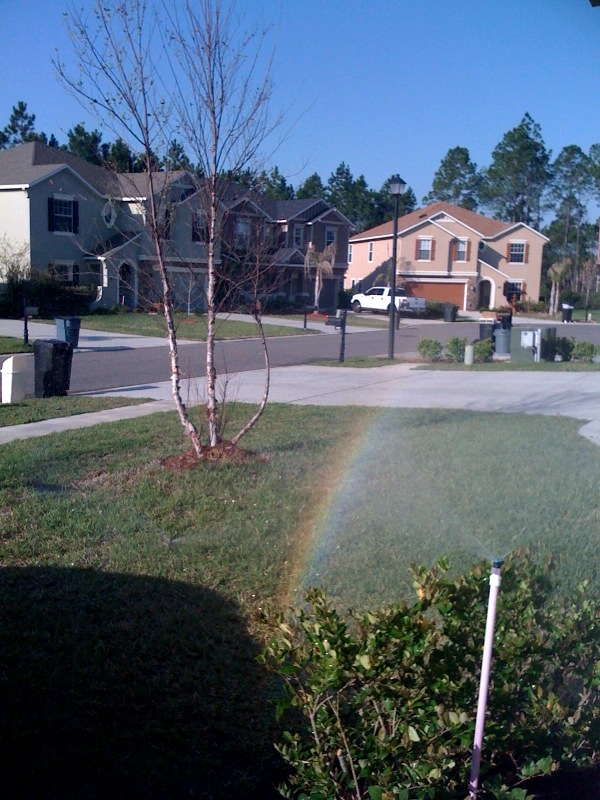
I hope you have a wonderful St. Patrick's Day. I am on my way to my parent's house for corned beef and cabbage. You see I did find my St. Patrick's Day rainbow in the sprinkler. I am not usually a big fan of watering a ton but in this dry pattern it is a must especially after I just fertilized the yard and planted a ton of new plants. You see the sunlight refracting off the backside of the water droplets. This brings us to our St. Patrick's Day blog question.
You can at least enjoy a lot of golden sunshine! I will have much more on the super moon and your big weekend so make sure to check back!
Monday, March 14, 2011
Lifeguard chairs, sea breezes, and winter's last hurrah
The main storm track will stay north of our area this week which means our big weather story is the warmest week of the year is here. Yesterday we talked about the positive East Pacific Oscillation that will bully the west with stormy weather while at the same time much of the country will warm up as this buckle in the jet stream allows warm air to go to work including some 90 degree weather possible in Texas! Notice the lifeguard chairs were taken out of storage at Jacksonville Beach. Up north many look for robins or sand hill cranes, here in Florida we look for the beach chairs and those strong afternoon sea breezes. When the sea breeze starts to kick in here at home it is a sure sign of Spring. We could see some gusty southeast wind speeds near 20 to 25 mph at times Tuesday and Wednesday so make sure your beach towels are anchored down so they do not blow away. Remember the sunscreen since we will have our highest UV index of the year. Even through the high clouds a sunburn will be possible in as little as 20 minutes. The Spring sea breeze will keep high temperatures near the beaches in the middle 70s while inland areas will have no trouble reaching 80 degrees. Be careful of patchy morning fog with a light wind and increasing humidity over the next couple days.
Speaking of clouds those streaks across the sky you saw at times today are called contrails. Here is a picture from this morning. They are condensation clouds created by planes or jets. Their engines release hot and humid air and the gas becomes a liquid as it cools in the much cooler air. In fact even though ground temperatures were near 80 today. Those man-made clouds formed where temperatures were below zero! The good news is those clouds did not last very long which tells us the atmosphere is dry. So this means even though we had a few wispy cirrus clouds move in as well today that no rain will be in the forecast any time soon. There is a slight chance of a shower in Georgia on Wednesday but do not count on it. Make sure to water your Spring flowers. The best boating weather of the year will continue with wind speeds remaining close to 10 knots through Friday and seas at 2-4 ft. Water temperatures will rise into the lower to middle 60s by the weekend!
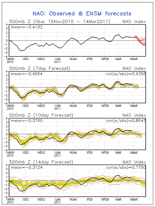
Long-range models do indicate this past weekend may have been winter's last hurrah with frost but it is a La Nina year and do not be surprised if nature tries to play an April Fool's joke on us here in Florida with a brief chilly spell or two by the end of the month and the first part of April. You see the NAO or North Atlantic Oscillation index forecast is predicted to go negative which means high latitude blocking. Focus on the top graph and the red lines. This pattern brought us vicious cold spells here in Florida this past winter, but now that it is Spring it should not be as bad for us at least! This will allow some cold air from Canada to move south. Much of Canada is still covered by snow and winter is far from done. You combine this weather index with the fact that La Nina's are known to have a winter that likes to linger and we will watch it carefully. But, I do believe most of the coldest weather will stay to our north when nature opens those wintry gates back up. We also have a much stronger sun angle to work with here in Florida which would help modify any polar air mass that tries to make a move on us. Spring begins on Sunday and I really think it is here to stay!
Subscribe to:
Posts (Atom)