Tuesday, July 8, 2008
Heavy Rain & Lightning the Main Threats over the Next Couple Hours
Everything is still on track with lightning and heavy rain the main threats. We did have one warning for southern Fountain County, but I have received no storm reports. I do not see training thunderstorms which is certainly a relief. Just be careful of ponding of water on the roadways as some areas could pick up a quick inch of rain with locally higher amounts close to 2 inches. Be safe and thanks for blogging and checking in with me. I wish I had more time to check in with you more often. But you are in good hands with Justin and Mary Anne while I am running the hallways here at WLFI, checking in with emergency management, and busy looking at Live Doppler 18 and Precision 18 storm scans. A special thanks to my weather intern Kevin Burris for helping to make sure Live Doppler 18 was updating on the web! Take care and thanks again.


Staying Alert & Watching Things Carefully
The Storm Prediction Center has indicated they are not anticipating extending a weather watch into our area. The main cold front which is not very strong to begin with is still located hundreds of miles from home. There is not much wind shear to work with and the low-level wind speeds are still fairly light which would limit any widespread severe weather. With that said we could still see an isolated wind gust of 60 mph, but the main threats still appear to be lightning and pockets of localized flooding. The areas I am watching most closely right now are south of Interstate 74 which includes Fountain and Montgomery Counties. But even Warren, Tippecanoe, and Clinton Counties will still have to watch things carefully. The strongest storms should pop between 6 p.m. and 10 p.m. tonight before another line of weaker thunderstorms moves through late tonight witht the main cold front.
Live Doppler 18 Is On Alert for Wind & Flooding
Hello! I hope you are having a great day. Get to the pool while you can. I am still thinking thunderstorms will start firing up after 3 p.m. Our main severe weather threat for wind damage will be between 3 p.m. and 7 p.m. and then training thunderstorms which could cause localized flooding will be our main threat after 7 p.m. tonight.
Remember your lightning safety rules and do not let your guard down when it comes to flooding. Most folks do not understand the power of water. Only one to two feet of water can sweep a vehicle away and every one foot rise in a water level exerts an additional 500 pounds of force on your car, which in essence makes your car 500 pounds lighter in a flooded roadway. Just think of how much easier it is to pick up somebody in a pool than outside it. This is the same concept. Unfortunately in this case it will be your car being picked up.
Straight-line winds also need to be taken seriously. New statistics in from NOAA confirm that twice as many people are hurt or injured with straight-line winds as EF-0 and EF-1 tornadoes. Incredible but true! Stay alert this evening and if at all possible limit your time outside or driving around in your car. If you can do this your chances of staying safe are much greater. I will keep you updated on the tube throughout the evening. Now it is off to work I go. Bloggers do your thing and I will check back with you if needed.
Remember your lightning safety rules and do not let your guard down when it comes to flooding. Most folks do not understand the power of water. Only one to two feet of water can sweep a vehicle away and every one foot rise in a water level exerts an additional 500 pounds of force on your car, which in essence makes your car 500 pounds lighter in a flooded roadway. Just think of how much easier it is to pick up somebody in a pool than outside it. This is the same concept. Unfortunately in this case it will be your car being picked up.
Straight-line winds also need to be taken seriously. New statistics in from NOAA confirm that twice as many people are hurt or injured with straight-line winds as EF-0 and EF-1 tornadoes. Incredible but true! Stay alert this evening and if at all possible limit your time outside or driving around in your car. If you can do this your chances of staying safe are much greater. I will keep you updated on the tube throughout the evening. Now it is off to work I go. Bloggers do your thing and I will check back with you if needed.
Nature Lets Out the Dogs, Dewpoints, and Downdrafts


This is vintage dog day weather. Notice Tiger on the right is licking his chops and BJ on the left looks like he is ready to pounce on the treats I was holding up. Who let the dogs out? Nature! You can walk to your mailbox out there this morning and get a good workout in. What happened to our comfortable weekend? The dewpoints are what happened. This is the true measure of humidity. When your dewpoints jump from the 50s to the 70s the atmosphere can hold twice as much water vapor. Notice the dewpoints above will be an unbearable 72 today after only being close to 56 on Saturday. The more water vapor in the air, the more uncomfortable it is, especially as temperatures climb into the 80s. Anytime your dewpoint reaches near 70 or above that is considered oppressive.
Why does it feel more like Florida, Mississippi, or Lousiana out there? You can blame this Bermuda high pressure off the East Coast you see below. When you walk outside it does feel like you are wrestling an alligator down in Bayou country.The clock-wise flow around this high pressure brings plenty of moisture or maritime tropical air our way. It is our heat pump this time of year and we really feel it as it expands and grows stronger in July and August. So remember to blame the Bermuda high and not me.
 I am an avid runner and I do tell runners to run mainly before 9 a.m. in this weather and after 8 p.m. at night. The heat really takes a toll on your body and it really is not worth taking a chance in that steambath outside. Your body simply cannot effectively cool itself down and if you push yourself too hard it can be really serious. You have to be weatherwise this time of year. Remember the most weather-related fatalities every year comes from not flooding or tornadoes, but hot weather.
Here is what you need to know.When you combine the heat and humidity there is what is called the heat index. When the heat index temperature is 94 or above like we will see today that when you have to exercise caution. Keep in mind this is a shade temperature. To find your runner's or workout temperature this time of year, take the actual temperature and add at least 15 degrees. Now if it becomes humid or If the dewpoints are 70 or above add 25 degrees. If it is a cloudy day in the summer with lower humidity you still add 10 degrees. So for instance today's forecast high is 87.When you use my formula and add 25 degrees with 70+ dewpoints it comes out to 112 degrees. This is your runner's temperature today at 4 p.m. Even this morning by 10 a.m. with temperatures near 80 the runner's temperature would still be 100 to 105. So remember the early bird gets the worm. Overdoing it in this weather is just not smart, even if you are Hercules. I do practice what I preach and over the weekend even with the comfortable humidity I did my 11.1 mile long run on the treadmill inside at the gym. The runner's temperature on Sunday afternoon when I was ready to conquer the 231 hill was in the middle to upper 90s so I took my workout inside. It was tougher than running outside, but well worth it.

Now you are not totally covered just yet in being weatherwise today. When you combine this heat and humidity with a cold front this time of year it can get even more interesting. Your typical late day storms will have a little more lift thanks to the cold front and you can get some pretty vicious wind gusts in a hurry. Today the Storm Prediction Center has us in a slight risk for severe weather. You can see our area outlined in yellow above. Last night there were several reports of 60 to 70 mph wind gusts in Iowa, Minnesota, and Wisconsin. This same set-up is in place here at home today and tonight. Even though we have light lower level and upper level winds you can still get some severe weather because some of these thunderstorms can build up to over 10 miles high in the sky. Here is a picture below for you to visualize this.

For every updraft that builds into a thunderstorm in as little as 20 minutes, you have a downdraft that develops when raindrops become heavy enough to fall to the ground. This downdraft can pick up quite a bit of momentum when it starts several miles high in the sky. Some cloud tops grow to well over 50,000 feet or more than 10 miles high in the sky. What a drop! Imagine what happens when a thunderstorm collapses. You can get what is called a microburst or straightline winds that can cause damage in a hurry. So today we will keep our guard up for not only lightning and heavy rain like we saw on Monday morning but some possible damaging wind gusts with those towering cumulonimbus clouds.
I will check back with you during the day as things get more interesting. For now though our weather blog song of the day none other than....I will let you guess before you click on it below. Bermuda high....Baha.....
Monday, July 7, 2008
Coolest July 4th in 11 Years Gives Way to A Steambath & Deluge!

We had one of our nicest July 4th weekends in several years. It is known as one of our stormiest holidays of the entire year when manmade fireworks are usually outdone by nature's fireworks. But not this year. A cool, stabilizing air mass arrived from Canada on the 4th helping to push all of the heat and humidity away. Now interestingly enough we did have a few light sprinkles reported just south of Frankfort just after 9 p.m. but they quickly dissipated. Nature ALWAYS makes things interesting. One interesting note is that we had our coolest July 4th since 1997 with a high temperature of only 76 degrees. If you thought that was impressive, northern Quebec had its first July snowflakes in more than ten years.
As we discussed on the blog on Friday, it takes a lot of things to go just right to keep thunderstorms away on the 4th here in the Lafayette viewing area and in this case if it was snow in Quebec that helped give the cooler air mass a little more push southward so be it! Everything is related in the world of weather that is for sure. I know I had a great weekend with my family. One of the many highlights included bowling. My daughters absolutely loved bowling. They take after their Mom and Dad. The very first date I went on with Julie was at the bowling alley so it is in their blood. We bowled and bowled and bowled, count them 6 games. The great part is that you are guaranteed a few strikes when you bowl that much. Even Lauren, our 3 year old had a strike. I didn't get a turkey, but came close a couple times. The great part was just spending good time together.

Now this morning nature had a few of its on strikes. Lightning strikes that is. We didn't have any weather warnings but did have some very impressive rainfall totals. Delphi averages 4 inches of rain the entire month of July. But Wendy had over 3 inches of rain or about 3 weeks worth of rain in about 3 hours. Kandy in Chalmers wasn't far behind with about 2.4 inches. The gully washer also hit Mary Anne in Remington with 2.3 inches. The farther south and east you went the less rain. Notice here at WLFI in West Lafayette we had .85". Here are more totals for you below.
 Unfortunately some areas like Monon and Kokomo had less than .20" of an inch. In fact Gene and Charlotte Austin in Monon were out watering their plants again today. They were also missed with last week's rain. This is certainly the time of year where some areas could have flooding while other areas need to water their plants and this was a good example.
We have no major fronts or storm systems this time of year as our jet stream lifts to the north and what happens is we have thunderstorms that pop up due to heat and humidity. These convective storms sometimes are less than a couple miles in diameter playing havoc with rainfall forecasts.
Last night we actually had a complex of thunderstorms form. The problem this time of year is that even if you get a big area of several thunderstorms they tend to die out toward morning as you lose the heating and areas that are farther downstream miss out on the rain. In this case it would be Kokomo and area farther north near Monon. But I do think all of us will have a good chance of seeing more heavy rain and maybe even some stronger storms. Make sure to tune in to find out why and I will keep you updated as always here on the blog.
Friday, July 4, 2008
It's Party Time! No Lightning Expected and Rain Threat Continues to Diminish
It now looks like the most danger out there today will not be any lightning on Live Doppler 18 for the rest of today and tonight, but grocery store parking lots. I just got a cell phone call from Julie and she is still looking for a place to park!
Now here is your special holiday update...the latest short range model runs do have some sunshine returning this afternoon and this daytime heating could pop an isolated rain shower between 6 p.m. and 8 p.m. The areas that may see a lone rain shower will be Fountain, Montgomery, and Clinton Counties. I do not expect these showers to build into thunderstorms and even the counties I listed above should be mainly rain-free. Areas to the north including Tippecanoe County are looking great as well. There is only a 10% chance of a rain shower! By late tonight an area of high pressure will build in and take over our holiday weekend forecast with our next chance of any pop up storms holding off until Monday.
I will be in the office tonight to track anything nature tries to throw at us. After all it has rained 9 of the past 11 4th of Julys. But remember anything I do track I expect to be brief at best and minor. You will likely see me grilling outside on the weather deck. So with all this good news my wife has this great 4th of July jello recipe to share with you. She credits Tammy Blackburn for sending it her way. Got a pen ready!
White Cake Mix
"Cool it"
"Poke it with the back of a wooden spoon"
2 packages of jello (strawberry and blueberry)
1 cup of boiling water
1 cup of cold water
Mix 1/2 cup of boling water and cold water with each package of jello
Pour in poked holes
Top with cool whip
Put strawberries and blueberries on top
Now your weather blog song of the day is really a patriotic song in honor of Independence Day! You've guessed it. Born in the USA by Bruce Springsteen. You cannot go wrong with the Boss! Happy 4th!
Now here is your special holiday update...the latest short range model runs do have some sunshine returning this afternoon and this daytime heating could pop an isolated rain shower between 6 p.m. and 8 p.m. The areas that may see a lone rain shower will be Fountain, Montgomery, and Clinton Counties. I do not expect these showers to build into thunderstorms and even the counties I listed above should be mainly rain-free. Areas to the north including Tippecanoe County are looking great as well. There is only a 10% chance of a rain shower! By late tonight an area of high pressure will build in and take over our holiday weekend forecast with our next chance of any pop up storms holding off until Monday.
I will be in the office tonight to track anything nature tries to throw at us. After all it has rained 9 of the past 11 4th of Julys. But remember anything I do track I expect to be brief at best and minor. You will likely see me grilling outside on the weather deck. So with all this good news my wife has this great 4th of July jello recipe to share with you. She credits Tammy Blackburn for sending it her way. Got a pen ready!
White Cake Mix
"Cool it"
"Poke it with the back of a wooden spoon"
2 packages of jello (strawberry and blueberry)
1 cup of boiling water
1 cup of cold water
Mix 1/2 cup of boling water and cold water with each package of jello
Pour in poked holes
Top with cool whip
Put strawberries and blueberries on top
Now your weather blog song of the day is really a patriotic song in honor of Independence Day! You've guessed it. Born in the USA by Bruce Springsteen. You cannot go wrong with the Boss! Happy 4th!
Happy 4th of July! Our "Staycations" Look Mainly Rain-Free
 Contrail clouds over Lafayettte as nature paints the sky with some red, white, and blue!
Happy Birthday America! The big day is here and it is also a big day for all meteorologists. It is like our Super Bowl. Sometimes it feels like you are calling the "Hail Mary" play when you forecast a mainly dry 4th of July weekend. That is because it is one of the toughest times of the year to forecast. You think my three daughters give me gray hairs. Try forecasting in Indiana during the big 4th of July weekend forecast. It is a good thing I love challenges. This year is an even bigger challenge because most folks are staying close to home with the high energy prices. How do you think I run marathons? Nature toughens me up that is for sure and through lots of preparation and I will keep a close eye on Live Doppler 18 and all the new model runs throughout the weekend. So why is it anything but a holiday for meteorologists?
There are many reasons. Here are the top two. It is the time of year when we have cold fronts that stall out over the Midwest. This happens because those cool pushes of air from Canada are usually not strong enough to push the warm and humid air too far south. The sun angle is too strong and it helps to build these stagnant tropical domes of air. To move these hot domes totally out of our weather picture is like trying to push a bowling ball with a feather. Be skeptical and worried about all cold fronts trying to pass through our area this time of year. We all remember the 10 inches plus of rain that hit our area during the 4th of July holiday back in 2003! The second big challenge is that we have pop up thunderstorms in the afternoon and evening with all of the heating taking place. These thunderstorms are sometimes less than 2 miles wide in diameter but if they are in the wrong place at the wrong time your nice fireworks forecast can become a forecast farce in a hurry.
At least Justin New sent in a picture of nature getting this big weekend off on the right foot. It is a good sign for us. I do think we will see more contrail clouds from planes than nature's nimbostratus or cumulonimbus clouds that bring gushes of rain this time of year. I think our best chance of rain over the weekend will be this morning and once again by late Monday as more heat and humidity build into the region. I will be brave and call for good fireworks weather tonight at 10 p.m. throughout the entire area. It will be comfortable with temperatures in the middle to upper 60s and only a slight chance of a shower.

The news gets even better! I see brilliant sunsets and sunrises this weekend due to our upper atmospheric flow coming from the northwest and pushing smoke particles our way. As the sunlight passes through a thicker layer of the atmosphere near the horizon it scatters out the longer wavelengths of orange and red. Nature's beautiful display can turn dazzling if you have particles like smoke, dust, or ash in the atmosphere which are bigger than the air molecules. This will cause the sunlight to be scattered even more and it turns the red colors into crimsons and orange colors into a fiery sky. You will be amazed at how much smoke is in the atmosphere. I shaded a lot of gray on the national map to depict this. The raging fires out West are bad, but the worst of the fires believe it or not are up in Canada and this upper-level smoke is expected to move our way.
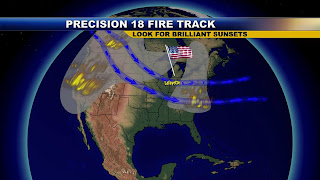 Now this upper-level smoke should not spoil our "staycations" which is the term we are giving to all those that have canceled their plans to travel long distances this year and stay closer to home due to those high gas prices. Looking for ideas? Well, yesterday I had the pleasure to meet The Atiso family who were our wlfi.com contest winners. We rewarded them with plenty of great food catered by DNR and Parretts, greased watermelon races, and even carriage rides out at Historic Prophetstown. I took a snap shot of the carriage ride. Those Belgian horses are certainly beautiful.
The Threshing Show will be going on out at Prophetstown this weekend with plenty of great things for the kids to do including camping.

Today make sure to tune in for the latest. Brian has you covered this morning and I will be babysitting Live Doppler 18 this evening. I leave with a picture of Tropical Storm Bertha. This is the big dog storm that will probably just maintain its intensity close to 45 mph winds over the next few days. But we will have to watch it closely by later next week and weekend as some maps have it curving toward the Carolinas. This is a definite sign of a busy season. I will have more on this here on the blog in the future. With parents in Jacksonville, Florida you better believe I will. Have a safe and wonderful weekend.
Subscribe to:
Posts (Atom)